University of Minnesota
http://www.umn.edu/
612-625-5000
http://www.umn.edu/
612-625-5000
Minnesota Biodiversity Atlas
Bell Museum
Dataset: MIN-Plants
Taxa: Araceae
Search Criteria: excluding cultivated/captive occurrences
Bell Museum plants | |
 MIN:Plants |  84432[1335724] s.n.1882-08-13 United States, Massachusetts, Middlesex |
MIN:Plants |  336366[1335725]Jr., John M. Fogg 109421936-06-26 United States, Pennsylvania, Wayne, About 1 mi. w. of Orson., 41.799998 -75.452736 |
MIN:Plants |  301452[1335726]Smith, L.B. 5371931-05-31 United States, Massachusetts, Essex |
MIN:Plants |  84435[1335727]L., W.H. s.n.1865-08-00 United States, New York, Hamilton |
MIN:Plants |  200576[1335728]Schofield, W.B. 12651950-07-26 Canada, Manitoba |
MIN:Plants |  467626[1335729]Stevens, O.A. 13381952-05-24 United States, North Dakota, Pembina |
MIN:Plants |  246265[1335730]Forbes, F. F. s.n.1902-06-04 United States, Massachusetts, West Roxbury, 42.279755 -71.162676 |
MIN:Plants |  618429[1335731]Abbe, E.C. 55291951-07-04 Canada, Ontario, Thunder Mountain, Thunder Cape., 48.3 -88.933333 |
MIN:Plants |  389576[1335732]W., S.C. 12201930-08-23 United States, Wisconsin, Washington, Bordering County Trunk "P" between Richfield and Holy Hill., 43.237196 -88.263182 |
MIN:Plants |  84447[1335733][illegible] s.n.1890-06-00 United States, Wisconsin, Barron |
MIN:Plants |  595761[1335734]Cody, W.J. 90141955-07-27 Canada, British Columbia, Mackenzie, Fort Simpson; Around border of slough near Royal Canadian Corps Signals Transmitters., 61.859717 -121.363545 |
MIN:Plants |  580953[1335735]Dutton, D.L. s.n.1925-06-15 United States, Vermont, Addison, Leicester Brook Swamp, 43.866729 -73.107891 |
MIN:Plants |  523407[1335736] s.n.1902-06-17 United States, Michigan, Cass Lake, 42.608243 -83.367779 |
MIN:Plants |  567269[1335737]Nattick 59321919-06-07 United States, Massachusetts, Middlesex |
MIN:Plants |  279529[1335738]Carpenter s.n.1929-06-21 United States, Vermont, Caledonia, Danville; Joe's Pond, 44.411168 -72.139264 |
MIN:Plants |  84434[1335739] s.n. United States, New York |
MIN:Plants |  961104[1334248]Timothy J. S. Whitfeld 17282018-06-12 United States, Rhode Island, Providence, Diamond Hill Reservation, 0.66 miles southeast of the intersection between West Wrentham Road and Pine Swamp Road., 42.0061667 -71.4351111 |
MIN:Plants |  963771[1352648]Welby R Smith 356002016-07-01 United States, Minnesota, St. Louis, On a low (often flooded) island in the St. Louis River just southwest of New Duluth. SE of SE of section, 46.65075 -92.2399722 |
MIN:Plants |  976585[1402175]Timothy J. S. Whitfeld 29822021-07-19 United States, Minnesota, St. Louis, Voyageurs National Park, Sand Point Lake, 0.25 mile east Brown's Bay, towards the southern end of the Bay, 48.36162 -92.53307, 345m |
MIN:Plants | MPCA_Dummy16[]Michael Bourdaghs 2021-08-17 United States, Minnesota, Aitkin, Savanna State Forest, Collected as part of the US Environmental Protection Agency National Wetland Condition Assessment (EPA siteID NWC21-MN-10030) and MN Pollution Control Agency MN Wetland Condition Assessment (MPCA siteID 21AITK030), 46.94420589 -93.37275414 |
MIN:Plants |  966670[1359351]Whitfeld, T.J.S., Weiblen, G.D., Yang, Y., & Lee, A.K. 28272021-06-29 United States, Minnesota, Crow Wing, Cross Lake Recreation Area; Arrowhead Lake; southeast shore, 46.718611 -94.217778 |
MIN:Plants | []Timothy J. S. Whitfeld 36262023-07-06 United States, Minnesota, Marshall, Agassiz National Wildlife Refuge, Agassiz Wilderness Area, south of Whiskey Lake, 4.8 miles north of main administration building, 48.3708 -95.9656, 346m |
MIN:Plants |  Anthurium scandens (Aublet) Engler 567300[1332995]Hunnewell, F. 171041941-02-16 Guatemala, Alta Verapaz, Tactic;;;;, 15.296894 -90.33951, 1311m |
MIN:Plants |  Anthurium scandens (Aublet) Engler 84345[1332996] 2563 Puerto Rico, Cerro Gordo Mountain., 18.34634 -66.179612 |
MIN:Plants |  Anthurium scandens (Aublet) Engler 224636[1332997] 50441916-03-12 Puerto Rico |
MIN:Plants |  Anthurium scandens (Aublet) Engler 224637[1332998]Fuertes, Miguel 4881910-07-00 Dominican Republic, Barahona |
MIN:Plants | 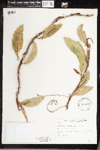 Anthurium scandens (Aublet) Engler 535197[1332999] 1217 Costa Rica, 1 mi. SE. of Cartago., 9.862823 -83.917596, 1433m |
MIN:Plants | 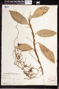 Anthurium scandens (Aublet) Engler 242441[1333000] C151501915-02-11 Jamaica, Cinchona Blue Mountains, Leeward Slopes., 17.995393 -76.564679 |
MIN:Plants | 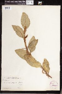 Anthurium scandens (Aublet) Engler 242440[1335001] C15499 Jamaica, Cinchona, Blue Mountains, Leeward Slopes, 17.995393 -76.564679 |
MIN:Plants | 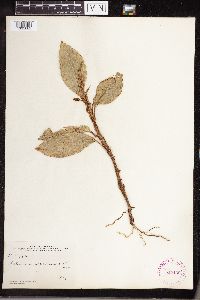 Anthurium scandens (Aublet) Engler 242439[1335002] C15389 Jamaica, Cinchona, Blue Mountains, Leeward Slopes, 17.995393 -76.564679 |
MIN:Plants |  Anthurium scandens (Aublet) Engler 242438[1335003] C15475 Jamaica, Cinchona, Blue Mountains, Windward Slopes, 18.022819 -76.545453 |
MIN:Plants |  Anthurium scandens (Aublet) Engler 242437[1335004] C15171 Jamaica, Cinchona Blue Mountains, Winward Slopes., 18.022819 -76.545453 |
MIN:Plants |  Anthurium scandens (Aublet) Engler 242435[1335005] C15436 Jamaica, Cinchona, Blue Mountains, Leeward Slopes, 17.995393 -76.564679 |
MIN:Plants |  Anthurium scandens (Aublet) Engler 242436[1335006] C15349 Jamaica, Cinchona. Blue Mountains, Windward Slopes, 18.022819 -76.545453 |
MIN:Plants |  Anthurium scandens (Aublet) Engler 295762[1335007]Yuncker, T.G. 4836 Honduras, Cortez, Near the shore of Lake Yojoa., 14.871674 -87.982476, 640m |
MIN:Plants |  Anthurium scandens (Aublet) Engler 295746[1335008]Yuncker, T.G. 4880 Honduras, Near the shore of Lake Yojoa, Cortez., 14.871674 -87.982476, 640m |
MIN:Plants |  Lemna obscura (Austin) Daubs 519592[1311611]Smith, Welby 147771988-08-08 United States, Minnesota, Washington, Washington County ...On the Mississippi River, about one mile south of St. Paul Park. NW1/4 SW1/4 section 13, T 27N R 22W. 027N 22W 13, 44.8252778 -93.0016667 |
MIN:Plants |  Lemna obscura (Austin) Daubs 432141[1337096]Eggert, H. s.n. United States, Illinois, St. Clair, St. Clair co; Fish Lake [this locality could not be found], 38.470305 -89.92841 |
MIN:Plants |  Lemna obscura (Austin) Daubs 590783[1337097]Bollwinkel, Carl 2631957-08-01 United States, Illinois, Monroe, NE 1/4, Sec 13 T3S R10W NW roadside, northernmost of a series of 4 ponds, by old undisturbed sink hole pond, 38.274666 -90.155417 |
MIN:Plants |  Lemna obscura (Austin) Daubs 591885[1337098]Abney 2121959-09-01 United States, Illinois, Union, Wolf Lake, 37.504216 -89.438427 |
MIN:Plants |  Lemna obscura (Austin) Daubs 84570[1337099]Umbach, L. M. s.n.1897-08-25 United States, Illinois, Will |
MIN:Plants |  Lemna obscura (Austin) Daubs 84572[1337100]Curtiss, A. H. 2695 United States, Florida, Volusia, Green Sulphur Springs, near Enterprise, 28.860498 -81.247329 |
MIN:Plants |  Lemna obscura (Austin) Daubs 359825[1337101]Godfrey, R. K. 9001939-07-26 United States, South Carolina, Williamsburg, 3 miles NW of Kingstree, 33.698438 -79.867609 |
MIN:Plants |  Lemna obscura (Austin) Daubs 589648[1337102]Lakela, Olga 273141964-07-21 United States, Florida, Miami dade, Homestead Bay Front Park, 25.775932 -80.186436 |
MIN:Plants |  Lemna obscura (Austin) Daubs 469739[1337103]Fernald, M. L. 109841939-08-24 United States, Virginia, Virginia beach city, along Back Bay, East of Munden, 36.65404 -76.03243 |
MIN:Plants |  Alocasia macrorrhizos (L.) G.Don 620508[1332957]Moore, John 1691926-10-05 French Polynesia, Raiatea, Society Islands, 1st valley SW of Uturoa.;;;;, -16.726482 -151.447529, 150m |
MIN:Plants |  Alocasia macrorrhizos (L.) G.Don 620372[1332958]Moore, John, W. 7631927-05-09 French Polynesia, Island of Raiatea; Cultivated 1 mile south of Fatuna., -16.797914 -151.401985, 3m |
MIN:Plants |  Alocasia macrorrhizos (L.) G.Don 368003[1332959][illegible] s.n.1912-08-00 French Polynesia |
MIN:Plants |  Alocasia macrorrhizos (L.) G.Don 272841[1332960]Tilden, Josephine E. 3571910-06-00 French Polynesia, Papahue, Paea, Tahiti, Society Islands, -17.666667 -149.583333 |
MIN:Plants |  Alocasia macrorrhizos (L.) G.Don 272840[1332961]Tilden, Josephine E. 3571910-06-00 French Polynesia, Papehue, Paea, Tahiti, -17.666667 -149.583333 |
MIN:Plants |  Lemna turionifera Landolt 84558[1337053]Nelson, Aven 64241899-08-12 United States, Wyoming, Teton, Yellowstone National Park. Snake River, 44.15518 -110.649128 |
MIN:Plants |  Lemna turionifera Landolt 566608[1337033]Moore, John W. 24307A1958-09-18 United States, Minnesota, Blue Earth, north east shore of Cottonwood Lake, N. E. 1/4 Sect 32, Medo Twp. [T106N;R25W], 43.942436 -93.858173 |
MIN:Plants |  Lemna turionifera Landolt 592169[1311627]Moore, John 266041964-05-25 United States, Minnesota, Blue Earth, Blue Earth County...south shore of Lake Alice.;;108N;25W;25, 44.130785 -93.778227 |
MIN:Plants |  Lemna turionifera Landolt 440823[1337030]Smith, Welby R. 114761986-05-17 United States, Minnesota, Anoka, Lamprey Pass State Wildlife Management Area, about 2 miles SW of Forest Lake; SW1/4 NE1/4 section 13, T 32N R 22W, 45.261258 -93.029708 |
MIN:Plants |  Lemna turionifera Landolt 263731[1337051]Nurnberger, P.K. P28301928-08-10 United States, Minnesota, Aitkin, Big Sandy Lake [Savanna State Forest; T49N;R23W], 46.72381 -93.254302 |
MIN:Plants |  Lemna turionifera Landolt 266997[1337032]Sheldon, E. P. S1181891-06-00 United States, Minnesota, Le Sueur, Elysian [T109N;R24W], 44.239498 -93.707142 |
MIN:Plants |  Lemna turionifera Landolt 270384[1337025]Gunderson, Harvey L. s.n.1940-07-02 United States, Minnesota, Saint Louis, Lester Park, Duluth. [T50N;R13W;S5], 46.844016 -92.016103 |
MIN:Plants |  Lemna turionifera Landolt 349729[1335992]Hedman, H. 531938-07-00 United States, Minnesota, Hennepin, N. shore Brown's Bay, Lake Minnetonka.;;117N;23W;, 44.934923 -93.584208 |
MIN:Plants |  Lemna turionifera Landolt 359122[1337056]Moyle, J. B. 33411939-07-26 United States, Minnesota, Benton, Mayhew Creek, 45.603343 -94.07039 |
MIN:Plants |  Lemna turionifera Landolt 360909[1337055]Moyle, J. B. 35601940-07-02 United States, Minnesota, Saint Louis, Fish hatchery pool, Duluth, 46.740336 -92.140616 |
MIN:Plants |  Lemna turionifera Landolt 370224[1337008]Moore, John 141871941-06-10 United States, Minnesota, Wilkin, West bank of Rabbit River, S.W. 1/4, Section 30, Champion Township, Wilkin County;;130N;45W;30, 46.043223 -96.379436 |
MIN:Plants |  Lemna turionifera Landolt 370794[1337022]Moore, John; et al. 137771941-05-03 United States, Minnesota, Washington, Roadside pond, N.E.1/4 Section 4, Oakdale Township, Washington County;;029N;21W;04, 45.028609 -92.934156 |
MIN:Plants |  Lemna turionifera Landolt 381413[1337054]Moore, John W. 156271942-06-29 United States, Minnesota, Stearns, Sauk River, Sauk Center [T126N;R34W], 45.71615 -94.953516 |
MIN:Plants |  Lemna turionifera Landolt 385751[1337019]Moyle, J. 38911944-09-20 United States, Minnesota, Saint Louis, St Louis Co. near Hibbing; in backwaters of Swan R.;;057N;20W;, 47.427155 -92.937689 |
MIN:Plants |  Lemna turionifera Landolt 386029[1337047]Moyle, J. B. 40321945-08-01 United States, Minnesota, Freeborn, Albert Lea Lake [Albert Lea Wildlife Management Area; T102N;R21W], 43.629478 -93.34871 |
MIN:Plants |  Lemna turionifera Landolt 386176[1337018]Moyle, J. 37921944-07-25 United States, Minnesota, Saint Louis, St Louis Co.; in T50 R17;;050N;17W;, 46.808717 -92.491816 |
MIN:Plants |  Lemna turionifera Landolt 387722[1337006]Aiken, Susan s.n.1976-04-14 United States, Minnesota, Wright, Wright Co, E.P.A. Monticello Field Station;;122N;25W;, 45.334954 -93.865768 |
MIN:Plants |  Lemna turionifera Landolt 412689[1337013]Moore, John; Moore, Marjorie 115981939-08-09 United States, Minnesota, Kittson, Kittson Co.; west line of Section 3, richardville Township;;163N;48W;3, 48.97022 -96.853365 |
MIN:Plants |  Lemna turionifera Landolt 412783[1335991]Moore, John; Moore, Marjorie 109901939-07-19 United States, Minnesota, Lake of the Woods, Lake of the Woods Co.; Pine Creek, Angle Inlet;Northwest Angle;168N;34W;, 49.344621 -95.028893 |
MIN:Plants |  Lemna turionifera Landolt 425836[1337015]Emanuel, J. 4961951-06-22 United States, Minnesota, Winona, Winona Co.; Crooked Slough-vic Winona;;107N;07W;, 44.052588 -91.672687 |
MIN:Plants |  Lemna turionifera Landolt 437191[1337014]Moore, John; Hall, Robert 166101944-06-14 United States, Minnesota, Renville, Renville Co.; beside Highway 19, 1/2 mile east of Morton;;113N;34W;, 44.585501 -94.934085 |
MIN:Plants |  Lemna turionifera Landolt 440833[1337039]Smith, Welby R. 114751986-05-17 United States, Minnesota, Anoka, Lamprey Pass State Wildlife Management Area, about 2 miles SW of Forest Lake. SW1/4 NE1/4 sec. 13, T 32N R 22W, 45.261258 -93.029708 |
MIN:Plants |  Lemna turionifera Landolt 441881[1337009]Moore, John; et al. 182431945-09-05 United States, Minnesota, Kittson, Kittson County...River at Hallock.;;161N;49W;, 48.760418 -96.996127 |
MIN:Plants |  Lemna turionifera Landolt 441936[1337016]Moore, John; Huff, N. 181651945-08-10 United States, Minnesota, Winona, Winona Co.; Whitewater River, near St. Charles.;;106N;10W;, 43.977049 -92.019166 |
MIN:Plants |  Lemna turionifera Landolt 441986[1337024]Moore, John W. 182831945-09-21 United States, Minnesota, Wabasha, 1/2 mile south, 1 mile east of Ireland Station below Wabasha., 44.372759 -92.045 |
MIN:Plants |  Lemna turionifera Landolt 444658[1337028]Moore, John W. 189701946-08-03 United States, Minnesota, Wright, 1 mile north west of Monticello [T121N;R25W], 45.278428 -93.832121 |
MIN:Plants |  Lemna turionifera Landolt 444684[1337048]Moore, John W. 183441945-10-06 United States, Minnesota, Mille Lacs, Vandel Creek 2 miles east of Milaca [T38N;R26W], 45.777674 -93.576336 |
MIN:Plants |  Lemna turionifera Landolt 444754[1335995]Moore, John; Huff, N. 186531946-06-15 United States, Minnesota, Wadena, Wadena Co.; 1 mile west of Verndale;;134N;35W;, 46.412369 -95.092825 |
MIN:Plants |  Lemna turionifera Landolt 445861[1337011]Moore, John; Huff, N. 180381945-07-26 United States, Minnesota, Morrison, Morrison Co.; 3 miles east of Randall;;130N;30W;, 46.063879 -94.452262 |
MIN:Plants |  Lemna turionifera Landolt 448354[1337026]Moore, John W. 189851946-08-07 United States, Minnesota, Clearwater, Headwaters of the Mississippi River; at the outlet of Lake Itasca. [Itasca State Park; T143N;R36W], 47.19557 -95.233216 |
MIN:Plants | Lemna turionifera Landolt 458906[]Moore, John; et al. 18959 a1946-08-03 United States, Minnesota, Benton, Benton County ... S. E. 1/4 Sec. 21, St. George Twonship.;;036N;29W;21, 45.596785 -93.954974 |
MIN:Plants |  Lemna turionifera Landolt 449068[1337046]Moore, John W. 167981944-08-03 United States, Minnesota, Itasca, 5 miles S.E. of Cohasset [T55N;R26W], 47.239081 -93.639543 |
MIN:Plants |  Lemna turionifera Landolt 488637[1337007]Moore, John 199571949-05-13 United States, Minnesota, McLeod, McLeod Co.; 1/2 mile east of Lester Prairie;;116N;27W;1, 44.884405 -94.020205 |
MIN:Plants |  Lemna turionifera Landolt 497526[1337052]Moore, John W. 202451949-06-22 United States, Minnesota, Beltrami, west shore of Lake Bemidji [T146N;R33W], 47.453829 -94.863614 |
MIN:Plants |  Lemna turionifera Landolt 500829[1335994]Moore, John 204241949-07-06 United States, Minnesota, Grant, Grant Co.; south end of Pomme de Terre Lake, 5 miles east of Elbow Lake.;;129N;41W;, 45.977343 -95.831612 |
MIN:Plants |  Lemna turionifera Landolt 508415[1337005]Smith, Welby 179231990-08-08 United States, Minnesota, Pennington, Pennington Co.; At the southeast end of the town of St. Hilaire; Red Lake River; T152N R43W SE1/4 of SE1/4 of Sec 6 Pennington Co.; At the southeast end of the town of St. Hilaire; Red Lake River; T 152N R 43W SE1/4 of SE1/4 of Sec 6. 152N 43W 6, 48.0355568 -96.2050018 |
MIN:Plants |  Lemna turionifera Landolt 514289[1337058]Smith, Welby R. 211871992-07-31 United States, Minnesota, Le Sueur, At the south end of Fish Lake, about 2 miles north of Elysian. T109N R24W SE1/4 of SE1/4 of Sec 23, 44.2272224 -93.6699982 |
MIN:Plants | Lemna turionifera Landolt 519683[1335998]Winkelman, J.; Hoffmann, J. 1009UM1996-07-05 United States, Minnesota, Washington, Upper Mississippi River Corridor; Washington County...Pool 2...UTM E501605 N4960499. Grey Cloud Chanel;;027N;22W;00, 44.8 -92.8 |
MIN:Plants |  Lemna turionifera Landolt 519688[1335999]Winkelman, J.; et al. 1026UM1996-06-24 United States, Minnesota, Goodhue, Upper Mississippi River Corridor; Goodhue County...Pool 3, River Mile 804.5...UTM E522695 N4946612.;Upper Mississippi National Wildlife Refuge;113N;15W;00, 44.6666667 -92.7166667 |
MIN:Plants |  Lemna turionifera Landolt 519873[1311629]Smith, Welby 211451992-07-28 United States, Minnesota, Fillmore, Dorer Memorial Hardwood State Forest. Fillmore County...in the Root River Valley, about 2 miles west-southwest of Peterson. In Big Springs Creek. T 104N R 9W SE1/4 of SE1/4 of Sec 26. 104N 09W 26, 43.7761116 -91.875 |
MIN:Plants |  Lemna turionifera Landolt 526196[1337057]Moore, John W. 211331951-06-27 United States, Minnesota, Todd, at north end of Little Birch Lake, at Ward Springs. [T127N;R33W], 45.803167 -94.829109 |
MIN:Plants |  Lemna turionifera Landolt 552266[1337049]Moyle, J. B. 41681947-07-06 United States, Minnesota, Marshall, Near Gatzke [T157N;R40W], 48.410321 -95.796428 |
MIN:Plants |  Lemna turionifera Landolt 554594[1335996]Moore, John 231861957-06-13 United States, Minnesota, Pipestone, Pipestone Co.; creek at Pipestone National Monument, Pipestone;Pipestone National Monument;106N;46W;, 43.979723 -96.367859 |
MIN:Plants |  Lemna turionifera Landolt 558493[1337021]Moore, John 237591958-06-10 United States, Minnesota, Kittson, Kittson Co.; at Kennedy.;;160N;48W;, 48.673758 -96.845285 |
MIN:Plants |  Lemna turionifera Landolt 568920[1337045]Moore, John W. 251651960-07-15 United States, Minnesota, Anoka, west shore of Fish Lake [Cedar Creek National History Area; T34N;R23W], 45.428063 -93.203997 |
MIN:Plants |  Lemna turionifera Landolt 611459[1337001]Lammers, Roberta s.n.1968-05-18 United States, Minnesota, Anoka, Anoka Co.; near Cedar Bog Lake, Cedar Creek Natural History Area.;Cedar Creek National History Area;034N;23W;, 45.428063 -93.203997 |
MIN:Plants |  Lemna turionifera Landolt 616625[1337037]Moore, John W. 41969-05-03 United States, Minnesota, Crow Wing, Crow Wing Natural History Area. At "Mallard Lake", NW1/4, SW1/4 Sec.22, Garrison Twp. [T44N;R28W], 46.27899 -93.863336 |
MIN:Plants |  Lemna turionifera Landolt 645926[1337012]Westkaemper, Remberta s.n.1973-06-00 United States, Minnesota, Stearns, Stearns Co.; 2 mi. W. Sartell;;125N;28W;, 45.628253 -94.229369 |
MIN:Plants |  Lemna turionifera Landolt 696554[1337029]Smith, Welby R. 8691978-07-24 United States, Minnesota, Wright, T. 122N. R. 26W. S.E.1/4 of Section 34, 45.328669 -93.931893 |
MIN:Plants |  Lemna turionifera Landolt 698056[1337020]Wheeler, Gerald; Glaser, Paul 28561978-05-23 United States, Minnesota, Beltrami, Approx. 2.5 miles north of the Waskish Airport on Route 72, just northeast of the road; large drainage ditch which parallels Route 72.;Red Lake Peatland Scientific Natural Area;155N;30W;32, 48.20025 -94.521005 |
Google Map
Google Maps is a web mapping service provided by Google that features a map that users can pan (by dragging the mouse) and zoom (by using the mouse wheel). Collection points are displayed as colored markers that when clicked on, displays the full information for that collection. When multiple species are queried (separated by semi-colons), different colored markers denote each individual species.