University of Minnesota
http://www.umn.edu/
612-625-5000
http://www.umn.edu/
612-625-5000
Minnesota Biodiversity Atlas
Bell Museum
Dataset: MIN-Plants
Taxa: Caryophyllaceae
Search Criteria: excluding cultivated/captive occurrences
Bell Museum plants | |
 MIN:Plants | Moehringia lateriflora (L.) Fenzl 453048[]Lee, Michael; et al. MDL36282004-06-15 United States, Minnesota, Becker, Sucker Creek County Park. Becker County...Sucker Creek Park on the southeast side of Big Detroit Lake, three miles southeast of the city of Detroit Lakes...T138N R41W NW1/4 of NE1/4 Sec. 13. 138N 41W 13, 46.767387 -95.806082 |
MIN:Plants | Moehringia lateriflora (L.) Fenzl 296485[]Mexia, Ynes 21601928-07-29 United States, Alaska, McKinley National Park ... Near center of N. Boundary of Park ... above Wonder Lake.;Denali National Park;;;, 63.45884 -150.86412, 700m |
MIN:Plants | Moehringia lateriflora (L.) Fenzl 431717[]Dahle, R.; et al. 020132002-05-30 United States, Minnesota, Mille Lacs, Mille Lacs County...Northeast of the town of Isle...T43 R25 NE1/4 of SE1/4 of Sec 4;;043N;25W;04, 46.2325 -93.4936111 |
MIN:Plants | Moehringia lateriflora (L.) Fenzl 920631[]Smith, Welby 185921991-05-23 United States, Minnesota, Morrison, Camp Ripley Military Reservation. Camp Ripley Military Reservation. Morrison County...Along East Bounary Road, about 2.5 km north of the airfield... UTM: 394700E 5107700N. T 131N R 30W SE1/4 of NW1/4 of Sec 32. 131N 30W 32, 46.1166667 -94.3627778 |
MIN:Plants | Moehringia lateriflora (L.) Fenzl 108946[]Sheldon, Edmund s.n. United States, Minnesota, Hennepin, Minneapolis;;N;;, 44.98 -93.26361 |
MIN:Plants | Moehringia lateriflora (L.) Fenzl 108947[]Sandberg, John s.n.1886-06-00 United States, Minnesota, Goodhue, Red Wing;;113N;14W;, 44.555216 -92.495543 |
MIN:Plants | Moehringia lateriflora (L.) Fenzl 108948[]Sheldon, Edmund s.n.1895-05-00 United States, Minnesota, Ramsey, Ramsey Co.;;;;, 45.03333 -93.08333 |
MIN:Plants | Moehringia lateriflora (L.) Fenzl 108949[]Sheldon, Edmund S20691892-06-00 United States, Minnesota, Mille Lacs Lake [spans Aitkin and Mille Lacs cos.];;;;, 46.228105 -93.636954 |
MIN:Plants | Moehringia lateriflora (L.) Fenzl 108950[]Sheldon, Edmund S74781894-05-00 United States, Minnesota, Scott, Scott Co.;;N;;, 44.644138 -93.589052 |
MIN:Plants | Moehringia lateriflora (L.) Fenzl 108951[]Sheldon, Edmund S9741891-05-00 United States, Minnesota, Hennepin, Twin Lake;;N;;, 44.991978 -93.336126 |
MIN:Plants | Moehringia lateriflora (L.) Fenzl 108952[]Burglehaus, F. s.n.1891-06-00 United States, Minnesota, Hennepin, [no further data];;;;, 45 -93.47 |
MIN:Plants | Moehringia lateriflora (L.) Fenzl 108953[]Moyer, Lycurgus; et al. s.n.1899-05-30 United States, Minnesota, Chippewa, Montevideo;;117N;40W;, 44.93463 -95.67577 |
MIN:Plants | Moehringia lateriflora (L.) Fenzl 108954[]Aiton, G. s.n.1890-05-00 United States, Minnesota, Hennepin, [Vicinity of Minneapolis];;N;;, 44.979965 -93.263836 |
MIN:Plants | Moehringia lateriflora (L.) Fenzl 108955[]Kassube, J. s.n.1878-05-00 United States, Minnesota, Hennepin, Minneapolis;;N;;, 44.98 -93.26361 |
MIN:Plants | Moehringia lateriflora (L.) Fenzl 108956[]Sheldon, Edmund S34331892-08-00 United States, Minnesota, Otter Tail, Eagle Lake;;N;;, 46.170819 -95.69185 |
MIN:Plants | Moehringia lateriflora (L.) Fenzl 108957[]Rosendahl, C. 2291902-05-31 United States, Minnesota, Houston, Spring Grove;;101N;07W;, 43.543923 -91.6707 |
MIN:Plants | Moehringia lateriflora (L.) Fenzl 108958[]Rosendahl, C. 2321902-05-31 United States, Minnesota, Houston, Spring Grove;;101N;07W;, 43.543923 -91.6707 |
MIN:Plants | Moehringia lateriflora (L.) Fenzl 108959[]Ainslie, G. 15101902-05-19 United States, Minnesota, Olmsted, Near Rochester;;106N;14W;00, 43.97834 -92.498342 |
MIN:Plants | Moehringia lateriflora (L.) Fenzl 108960[]Sheldon, Edmund S22481892-06-00 United States, Minnesota, Crow Wing, Bordin Lake;;N;;, 46.305 -93.854444 |
MIN:Plants | Moehringia lateriflora (L.) Fenzl 108961[]Frost, W. F741892-06-00 United States, Minnesota, Meeker, Litchfield;;119N;31W;, 45.109214 -94.56847 |
MIN:Plants | Moehringia lateriflora (L.) Fenzl 108962[]Taylor, B. T12761892-06-00 United States, Minnesota, Chisago, Center City;;N;;, 45.393852 -92.816602 |
MIN:Plants | Moehringia lateriflora (L.) Fenzl 108963[]Sandberg, John s.n.1890-06-00 United States, Minnesota, Hennepin, [no further data];;;;, 45 -93.47 |
MIN:Plants | Moehringia lateriflora (L.) Fenzl 108964[]Sandstein, E. s.n.1891-07-00 United States, Minnesota, Ramsey, Ramsey Co.;;;;, 45.03333 -93.08333 |
MIN:Plants | Moehringia lateriflora (L.) Fenzl 108965[]Herrick, C. 39-71877-06-16 United States, Minnesota, Hennepin, Minneapolis;;N;;, 44.98 -93.26361 |
MIN:Plants | Moehringia lateriflora (L.) Fenzl 108966[]Ballard, C. B3921891-07-00 United States, Minnesota, Scott, Jordan;;114N;24W;, 44.666907 -93.626901 |
MIN:Plants | Moehringia lateriflora (L.) Fenzl 108967[]Sheldon, Edmund S5121891-06-00 United States, Minnesota, Waseca, Waseca Co.;;;;, 44.022123 -93.587283 |
MIN:Plants | Moehringia lateriflora (L.) Fenzl 108968[]Ballard, C. B511891-06-00 United States, Minnesota, Carver, Chaska;;;;, 44.78944 -93.60194 |
MIN:Plants | Moehringia lateriflora (L.) Fenzl 108969[]Taylor, B. T2801891-06-00 United States, Minnesota, Waseca, Janesville;;N;;, 44.116078 -93.708004 |
MIN:Plants | Moehringia lateriflora (L.) Fenzl 108970[]Aiton, G. s.n.1891-06-00 United States, Minnesota, Hennepin, near Minneapolis;;N;;, 44.98 -93.26361 |
MIN:Plants | Moehringia lateriflora (L.) Fenzl 108971[]Aiton, G. s.n.1877-06-00 United States, Minnesota, Hennepin, [no further data];;;;, 45 -93.47 |
MIN:Plants | Moehringia lateriflora (L.) Fenzl 264458[]Holzinger, John s.n.1901-05-04 United States, Minnesota, Winona, Winona Co.;;N;;, 43.936346 -91.686007 |
MIN:Plants | Moehringia lateriflora (L.) Fenzl 265911[]Skinner, S. 1631902-06-19 United States, Minnesota, Jackson, Heron Lake region;;N;;, 43.794959 -95.320276 |
MIN:Plants | Moehringia lateriflora (L.) Fenzl 276136[]Moyle, J. 561920-06-24 United States, Minnesota, Clearwater, Itasca Park, Lake Itasca, SW-NE-11, T143, R36;Itasca State Park;143N;36W;11, 47.217521 -95.201495 |
MIN:Plants | Moehringia lateriflora (L.) Fenzl 277743[]Roberts, Thomas s.n.1878-05-06 United States, Minnesota, Hennepin, Minneapolis;;N;;, 44.98 -93.26361 |
MIN:Plants | Moehringia lateriflora (L.) Fenzl 281825[]Sanford, J. s.n.1948-05-12 United States, Minnesota, Hennepin, Fort Snelling Area;Fort Snelling Military Reservation;N;;, 44.905162 -93.166462 |
MIN:Plants | Moehringia lateriflora (L.) Fenzl 288304[]Erickson, Lawrence s.n.1915-05-00 United States, Minnesota, Hennepin, Minnehaha Glen;Minnehaha Falls Park;028N;23W;, 44.905162 -93.166462 |
MIN:Plants | Moehringia lateriflora (L.) Fenzl 288487[]Johnson, Ruth 491900-05-24 United States, Minnesota, Ramsey, Groveland Park [St. Paul neighborhood between Highland and Summit aves.];;028N;23W;00, 44.90516 -93.16646 |
MIN:Plants | Moehringia lateriflora (L.) Fenzl 288537[]Beach, W. 1021914-05-19 United States, Minnesota, Hennepin, Minnehaha Glen;;N;;, 44.905162 -93.166462 |
MIN:Plants | Moehringia lateriflora (L.) Fenzl 306795[]Rosendahl, C. 2023M1935-06-21 United States, Minnesota, Mahnomen, 4 mi E of Beaulieu;;145N;40W;, 47.367744 -95.741574 |
MIN:Plants | Moehringia lateriflora (L.) Fenzl 351054[]Seashore, Mauritz s.n.1932-05-15 United States, Minnesota, Dakota, Dakota Co.;;N;;, 44.693669 -93.057253 |
MIN:Plants | Moehringia lateriflora (L.) Fenzl 353454[]Lakela, Olga 24131938-06-05 United States, Minnesota, Saint Louis, Brookston;;N;;, 46.86772 -92.603804 |
MIN:Plants | Moehringia lateriflora (L.) Fenzl 353911[]Moyle, J. 10881934-06-24 United States, Minnesota, Clearwater, Itasca Park, NW-NW-12, T143, R36;Itasca State Park;143N;36W;12, 47.217742 -95.180169 |
MIN:Plants | Moehringia lateriflora (L.) Fenzl 356075[]Rosendahl, C.; Dahlberg, R. s.n.1918-08-00 United States, Minnesota, Marshall, Golden Valley;;N;;, 48.324005 -95.916368 |
MIN:Plants | Moehringia lateriflora (L.) Fenzl 362018[]Moyle, J. 35451940-06-23 United States, Minnesota, Lake, near Two Harbors;;N;;, 47.022711 -91.670732 |
MIN:Plants | Moehringia lateriflora (L.) Fenzl 362320[]Lakela, Olga 35201940-06-12 United States, Minnesota, Carlton, stream bank on Hwy 23, ca 3 mi S of Blackhoof;;N;;, 46.48929 -92.462138 |
MIN:Plants | Moehringia lateriflora (L.) Fenzl 362910[]Lakela, Olga 35971948-06-30 United States, Minnesota, Saint Louis, bank of Mission Creek, Fond du Lac;;048N;15W;, 46.657011 -92.257257 |
MIN:Plants | Moehringia lateriflora (L.) Fenzl 363200[]Beach, W. 751913-05-19 United States, Minnesota, McLeod, Hutchinson;;N;;, 44.88774 -94.369706 |
MIN:Plants | Moehringia lateriflora (L.) Fenzl 368883[]Moore, John; et al. 139581941-05-11 United States, Minnesota, Fillmore, N facing slope above Hwy 43, 3 1/2 mi S of Rushford;;;;, 43.757603 -91.752926 |
MIN:Plants | Moehringia lateriflora (L.) Fenzl 369843[]Moore, John; et al. 139741941-05-23 United States, Minnesota, Isanti, beside Hwy 65, 1 1/2 mi N of the Anoka-Isanti Co. line;;;;, 45.432106 -93.23407 |
MIN:Plants | Moehringia lateriflora (L.) Fenzl 371075[]Moore, John; et al. 138841941-05-10 United States, Minnesota, Mower, N bank of Deer Creek, along Hwy 63, Frankford Twp;;103N;14W;, 43.717809 -92.50951 |
MIN:Plants | Moehringia lateriflora (L.) Fenzl 371513[]Moore, John; et al. 149391941-08-06 United States, Minnesota, Isanti, Along Rum River,1/2 mi N of West Point. Isanti Co.;;;;, 45.564436 -93.387672 |
MIN:Plants | Moehringia lateriflora (L.) Fenzl 371552[]Moore, John; et al. 149591941-08-07 United States, Minnesota, Kanabec, Along Snake River, 1/2 mi S of Mora, Kanabec Co.;;039N;24W;, 45.860683 -93.327529 |
MIN:Plants | Moehringia lateriflora (L.) Fenzl 372480[]Moore, John; et al. 145481941-06-15 United States, Minnesota, Red Lake, Clearwater River, 1/2 mi N of Plummer, on Hwy 59;;151N;42W;, 47.891159 -96.031763 |
MIN:Plants | Moehringia lateriflora (L.) Fenzl 372601[]Moore, John; et al. 144561941-06-14 United States, Minnesota, Kittson, South Fork of Two Rivers, 9 mi NE of Karlstad;;;;, 48.78797 -97.0921 |
MIN:Plants | Moehringia lateriflora (L.) Fenzl 372831[]Moore, John; et al. 143951941-06-14 United States, Minnesota, Polk, Polk County...2 mi SW of Fertile;Agassiz Dunes Scientific Natural Area;147N;44W;, 47.543099 -96.259086 |
MIN:Plants | Moehringia lateriflora (L.) Fenzl 374063[]Linnaean Club, U of M, 51939-05-21 United States, Minnesota, Rice, Nerstrand Woods;Nerstrand Woods State Park;110N;19W;, 44.32706 -93.10089 |
MIN:Plants | Moehringia lateriflora (L.) Fenzl 381139[]Moore, John; et al. 152701942-06-11 United States, Minnesota, Isanti, Isanti County...NW1/4 Sec. 32 Stanchfield Twp.;;;;, 45.68583 -93.19528 |
MIN:Plants | Moehringia lateriflora (L.) Fenzl 381616[]Moore, John; et al. 151631942-05-22 United States, Minnesota, Todd, 1/2 mi W of Motley;;;;, 46.33666 -94.68777 |
MIN:Plants | Moehringia lateriflora (L.) Fenzl 381846[]Allison, Helen s.n.1944-05-30 United States, Minnesota, Grant, on E shore of Lake Pelican;;N;;, 46.0675 -95.827778 |
MIN:Plants | Moehringia lateriflora (L.) Fenzl 396940[]Stevens, O. s.n.1948-05-23 United States, Minnesota, Clay, [no further data];Buffalo River State Park;139N;46W;10, 46.869327 -96.473428 |
MIN:Plants | Moehringia lateriflora (L.) Fenzl 407157[]Lakela, Olga 95381949-08-29 United States, Minnesota, Saint Louis, Lake Kabetogama near Park Point Resort;Voyageurs National Park;;;, 48.48028 -93.055 |
MIN:Plants | Moehringia lateriflora (L.) Fenzl 413633[]Moore, John; et al. 109751939-07-19 United States, Minnesota, Lake of the Woods, near Pine Creek, Angle Inlet;Northwest Angle;168N;34W;, 49.344621 -95.028893 |
MIN:Plants | Moehringia lateriflora (L.) Fenzl 429513[]Smith, Welby 152051989-05-31 United States, Minnesota, Freeborn, Carex Wildlife Management Area. Freeborn co.; 'Carex' State Wildlife Management Area, about 7 miles east-southeast of Hollandale. NW1/4 NW1/4 section 23, T 103N R 19W. 103N 19W 23, 43.7155556 -93.0866667 |
MIN:Plants | 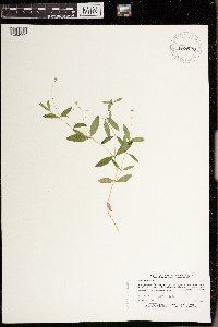 Moehringia lateriflora (L.) Fenzl 430570[1404932]Dana, R. 920131992-06-26 United States, Minnesota, Kittson, Kittson Co.; Woodland north of Roseau River; T 164N R 45W SW1/4 of NW1/4 of Sec 36;;164N;45W;36, 48.986523 -96.416367 |
MIN:Plants | Moehringia lateriflora (L.) Fenzl 435055[]Porupsky, A. 13451999-06-15 United States, Minnesota, Sherburne, Sherburne National Wildlife Refuge; SESW 22-35-27;Sherburne National Wildlife Refuge;035N;27W;22, 45.508655 -93.685329 |
MIN:Plants | Moehringia lateriflora (L.) Fenzl 437143[]Moore, John; et al. 162161944-05-26 United States, Minnesota, Dakota, Dakota County...Chimney Rock;;114N;17W;31, 44.637214 -92.903724 |
MIN:Plants | Moehringia lateriflora (L.) Fenzl 442605[]Lakela, Olga 124101951-06-09 United States, Minnesota, Saint Louis, Floodwood River terrace 7 mi N of Floodwwod;;N;;, 46.9753 -92.92078 |
MIN:Plants | Moehringia lateriflora (L.) Fenzl 442718[]Lakela, Olga 123961951-06-09 United States, Minnesota, Saint Louis, surrounding a pond off Floodwood River, & mi N of Floodwood;;N;;, 47.00235 -92.92389 |
MIN:Plants | Moehringia lateriflora (L.) Fenzl 444877[]Moore, John 171351945-06-09 United States, Minnesota, Morrison, 1 mi S of Motley;;N;;, 46.322154 -94.646125 |
MIN:Plants | Moehringia lateriflora (L.) Fenzl 446013[]Moore, John; et al. 172321945-06-18 United States, Minnesota, Pennington, Pennington County...2 1/2 mi N of Thief River Falls;;;;, 48.137191 -96.175395 |
MIN:Plants | Moehringia lateriflora (L.) Fenzl 446124[]Moore, John; Huff, N. 196361947-06-19 United States, Minnesota, Swift, Swift Co. Monson Lake State Memorial Park;Monson Lake State Park;121N;37W;, 45.282126 -95.316523 |
MIN:Plants | Moehringia lateriflora (L.) Fenzl 446148[]Moore, John; et al. 172831945-06-18 United States, Minnesota, Roseau, Roseau County...8 mi E of Greenbush;;;;, 48.700531 -96.16414 |
MIN:Plants | Moehringia lateriflora (L.) Fenzl 448665[]Moore, John; Huff, N. 192691946-09-12 United States, Minnesota, Big Stone, Big Stone Co.; Toqua Lakes State Scenic Wayside Park, 1/2 mi S of Graceville;Toqua Lakes Scenic Wayside Park;124N;46W;, 45.542392 -96.431449 |
MIN:Plants | Moehringia lateriflora (L.) Fenzl 448728[]Moore, John 171141945-06-08 United States, Minnesota, Stearns, 1 mi E of Sauk Center;;126N;34W;, 45.7161504 -94.9535164 |
MIN:Plants | Moehringia lateriflora (L.) Fenzl 454255[]Lee, Michael; et al. MDL12721996-06-10 United States, Minnesota, Benton, Benton Co.; Six miles northwest of Milaca; T38N R28W NW1/4 NE1/4 Sec. 13;;038N;28W;13, 45.78593 -93.772872 |
MIN:Plants | 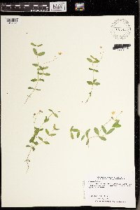 Moehringia lateriflora (L.) Fenzl 456286[1404941]Dahle, R. 960031996-06-06 United States, Minnesota, Mille Lacs, Mille Lacs Wildlife Management Area. Mille Lacs Co.; About six miles southsoutheast of Onamia, in the Mille Lacs WMA, just north of the northeast tip of Kars Mille Lacs Co.; About six miles southsoutheast of Onamia, in the Mille Lacs WMA, just north of the northeast tip of Karsness pool; T 41N R 26W NW1/4 of NE1/4 of Sec 27. 041N 26W 27, 46.003488 -93.610577 |
MIN:Plants | 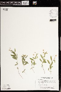 Moehringia lateriflora (L.) Fenzl 456878[1404938]Myhre, K. 48591994-05-27 United States, Minnesota, Itasca, Itasca Co.; located on the island in Rice Lake; T 148N R 27W NW1/4 of SW1/4 of Sec 1;Chippewa National Forest / Leech Lake Indian Reservation;148N;27W;1, 47.66524 -94.0464 |
MIN:Plants | 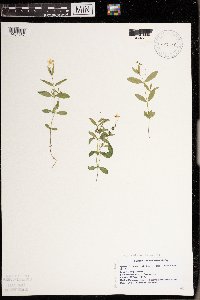 Moehringia lateriflora (L.) Fenzl 457238[1404937]Swanson, Gary s.n.1997-05-30 United States, Minnesota, Sherburne, Sherburne National Wildlife Refuge; NENW 16-35-27 [twp & rg];Sherburne National Wildlife Refuge;035N;27W;16, 45.52313 -93.70595 |
MIN:Plants | 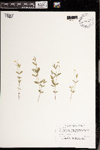 Moehringia lateriflora (L.) Fenzl 460186[1404933]Myhre, K. 35881993-05-17 United States, Minnesota, Pine, Saint Croix State Park. Pine Co.; Located 1 mile southwest of St. John's Landing Camp; near the public access; T 40N R 18W SW1/4 of SW1/4 of SEc Pine Co.; Located 1 mile southwest of St. John's Landing Camp; near the public access; T 40N R 18W SW1/4 of SW1/4 of SEc 1. 040N 18W 1, 45.979814 -92.541081 |
MIN:Plants | Moehringia lateriflora (L.) Fenzl 460751[]Myhre, K. 46841993-09-21 United States, Minnesota, Pine, Pine Co.; Located six miles west of the town of Sandstone; T 42N R 21W SE1/4 of NW1/4 of Sec 16;;042N;21W;16, 46.121966 -93.001853 |
MIN:Plants | Moehringia lateriflora (L.) Fenzl 462912[]Lakela, Olga 151931952-07-17 United States, Minnesota, Saint Louis, Point on N shore of Kabetogama Lake, 3 mi W of Pine Island;Voyageurs National Park;069N;21W;, 48.456965 -93.026751 |
MIN:Plants | Moehringia lateriflora (L.) Fenzl 463408[]Lakela, Olga 149141952-07-13 United States, Minnesota, Saint Louis, Beach of Pine Island, Kabetogama Lake;Voyageurs National Park;069N;21W;, 48.456965 -93.026751 |
MIN:Plants | Moehringia lateriflora (L.) Fenzl 463842[]Nation, R. 94-0211994-05-26 United States, Minnesota, Mower, Lake Louise State Park. Mower Co.; T101N R14W SW1/4 of SE1/4 of Cec. 21;Lake Louise State Park;101N;14W;21, 43.536578 -92.519043 |
MIN:Plants | Moehringia lateriflora (L.) Fenzl 463843[]Nation, R. 94-0251994-05-26 United States, Minnesota, Mower, Lake Louise State Park. Mower Co.; Tract 1A. T101N R14W NW1/4 of SW1/4 of Sec. 21;Lake Louise State Park;101N;14W;21, 43.536578 -92.519043 |
MIN:Plants | Moehringia lateriflora (L.) Fenzl 473300[]Swanson, Gary s.n.1997-05-30 United States, Minnesota, Sherburne, Sherburne National Wildlife Refuge; Locality: NENW 16-35-27;Sherburne National Wildlife Refuge;035N;27W;16, 45.52313 -93.70595 |
MIN:Plants | Moehringia lateriflora (L.) Fenzl 488675[]Moore, John 200631949-06-02 United States, Minnesota, Clay, 6 mi W of Hawley;;N;;, 46.880723 -96.443807 |
MIN:Plants | Moehringia lateriflora (L.) Fenzl 503062[]Moore, John 205391950-06-06 United States, Minnesota, Stevens, N end of Lower Pomme de Terre Lake;;N;;, 46.02342 -95.883255 |
MIN:Plants | 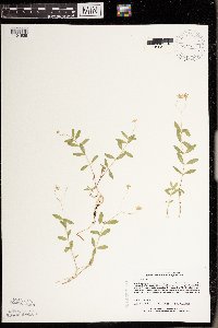 Moehringia lateriflora (L.) Fenzl 508435[1404939]Lee, Michael MDL9941995-06-09 United States, Minnesota, Wabasha, McCarthy Lake Wildlife Management Area. Wabasha Co.; along old channels of the Zumbro River in the Mississippi RIver floodplain 3 mi SSE of Kellogg; McCarthy La Wabasha Co.; along old channels of the Zumbro River in the Mississippi RIver floodplain 3 mi SSE of Kellogg; McCarthy Lake WMA. T109N R10W NWSW 1. 109N 10W 1, 44.249964 -91.954363 |
MIN:Plants | 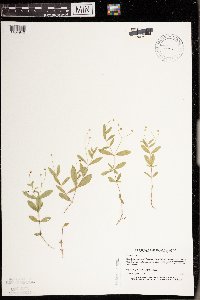 Moehringia lateriflora (L.) Fenzl 520169[1404940]Myhre, K. 23391992-06-23 United States, Minnesota, Cass, Cass Co.; plants located on Ottertail Peninsula in Leech Lake; T144N R29W NW1/4 of NE1/4 of Sec 30;Chippewa National Forest / Leech Lake Indian Reservation;144N;29W;30, 47.25962 -94.399224 |
MIN:Plants | Moehringia lateriflora (L.) Fenzl 525648[]Lakela, Olga 187001955-06-05 United States, Minnesota, Saint Louis, Hwy border #73, S of Gheen;;;;, 47.92393 -92.83155 |
MIN:Plants | Moehringia lateriflora (L.) Fenzl 526676[]Lakela, Olga 173581954-06-08 United States, Minnesota, Saint Louis, Little Fork River at the bridge, Hwy No. 73;;N;;, 47.85798 -92.87009 |
MIN:Plants | Moehringia lateriflora (L.) Fenzl 526714[]Lakela, Olga 172961954-06-07 United States, Minnesota, Saint Louis, Sand River woods, N of Toivola on Hwy No. 5;;N;;, 47.16921 -92.81085 |
MIN:Plants | Moehringia lateriflora (L.) Fenzl 527165[]Lakela, Olga 174691954-06-16 United States, Minnesota, Saint Louis, Ash River bank about 3 mi N of Ash Lake, Hwy 53;;N;;, 48.257357 -92.934025 |
MIN:Plants | Moehringia lateriflora (L.) Fenzl 532397[]Lakela, Olga 197231956-06-11 United States, Minnesota, Saint Louis, Bank of Little Swan River near the cemetery;;N;;, 47.29485 -92.84456 |
MIN:Plants | Moehringia lateriflora (L.) Fenzl 532741[]Lakela, Olga 106701956-06-09 United States, Minnesota, Saint Louis, terrace of Paleface River N of Cotton, Hwy No. 53;;N;;, 47.21012 -92.48823 |
MIN:Plants | Moehringia lateriflora (L.) Fenzl 542746[]Moore, John; et al. 214721952-05-18 United States, Minnesota, Anoka, Anoka County...Cedar Creek Forest, 49D, Lawrence's Woods;Cedar Creek National History Area;034N;23W;, 45.428063 -93.203997 |
MIN:Plants | Moehringia lateriflora (L.) Fenzl 550347[]Cotter Tucker, Shirley 40821957-06-10 United States, Minnesota, Polk, Polk County...along Great Northern rr tracks, E of NW School of Agriculture [Univ. of Minn.], Crookston;;150N;46W;, 47.80378 -96.546331 |
MIN:Plants | Moehringia lateriflora (L.) Fenzl 558405[]Moore, John 237701958-06-10 United States, Minnesota, Kittson, 5 mi W of Karlstad;;N;;, 48.577425 -96.629968 |
MIN:Plants | Moehringia lateriflora (L.) Fenzl 561401[]Ovington, John s.n.1959-05-25 United States, Minnesota, Anoka, Cedar Creek Natural History Area;Cedar Creek National History Area;034N;23W;, 45.428063 -93.203997 |
MIN:Plants | Moehringia lateriflora (L.) Fenzl 566703[]Lang, H.; et al. 591878-05-25 United States, Minnesota, Hennepin, Minneapolis;;;;, 44.98 -93.26361 |
Google Map
Google Maps is a web mapping service provided by Google that features a map that users can pan (by dragging the mouse) and zoom (by using the mouse wheel). Collection points are displayed as colored markers that when clicked on, displays the full information for that collection. When multiple species are queried (separated by semi-colons), different colored markers denote each individual species.