University of Minnesota
http://www.umn.edu/
612-625-5000
http://www.umn.edu/
612-625-5000
Minnesota Biodiversity Atlas
Bell Museum
Dataset: MIN-Plants
Taxa: Caryophyllaceae
Search Criteria: excluding cultivated/captive occurrences
Bell Museum plants | |
 MIN:Plants | Stellaria crispa Chamisso & Schlechtendal 525416[]Hardy, Robert 1681945-07-08 United States, Alaska, Attu Is. ... west side of Chichagof Harbor.;Aleutian Islands Wilderness;;;, 52.9 172.9 |
MIN:Plants | Stellaria crispa Chamisso & Schlechtendal 663802[]Noble, Mark; et al. 5721974-08-05 United States, Alaska, on the shoulder of Mt. Wright;Glacier Bay National Park;;;, 58.809784 -136.05167, 780m |
MIN:Plants | Stellaria crispa Chamisso & Schlechtendal 107218[]Conard, Henry 2061902-06-28 United States, Washington, Grays Harbor, Near river, 3 mi. above lake, Quiniault [sic] Valley;Olympic National Park;;;, 47.468093 -123.84669 |
MIN:Plants |  Stellaria crispa Chamisso & Schlechtendal 953689[1294540]Eyerdam, W. J. 3820 United States, Alaska |
MIN:Plants |  Stellaria crispa Chamisso & Schlechtendal 956137[1296089]Lawrence, D. B. s.n.1952-08-17 United States, Alaska, Glacier Bay National Monument. Camp Muir. [Glacier Bay National Park], 58.797428 -136.838127 |
MIN:Plants |  Stellaria crispa Chamisso & Schlechtendal 956141[1296076]Lawrence, D. B. s.n.1952-08-18 United States, Alaska, Glacier Bay National Monument. Camp Muir. [Glacier Bay National Park], 58.797428 -136.838127 |
MIN:Plants | 394012[]Butters, F.; Moore, John 108621939-07-04 United States, Minnesota, Cook, In the vicinity of McFarland Lake Resort.;Superior National Forest;064N;03E;, 48.018792 -90.055527 |
MIN:Plants |  436526[1404862]Bolling, G. 41997-06-22 United States, Minnesota, Hennepin, Hennipen [sic] Co.; North side of highway 7, 1/2 mile up Tonkawood Drive, Minnetonka;;117N;22W;, 44.93506 -93.461906 |
MIN:Plants | 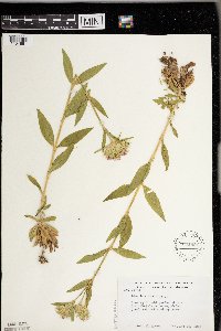 591951[1404861]Moore, John 267421965-06-28 United States, Minnesota, Anoka, In garden at the John Michelson house, Cedar Creek Natural History Area;Cedar Creek National History Area;034N;23W;, 45.428063 -93.203997 |
MIN:Plants | 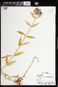 962880[1346481]Whitfeld, T.J.S. 24422019-08-29 United States, Minnesota, Itasca, Us Army Corps of Engineers Winnibigoshish Recreation Area, campground, 47.429328 -94.047606 |
MIN:Plants | Wilhelmsia physodes (Fischer ex Seringe) McNeill 296484[]Mexia, Ynes 21721928-08-01 United States, Alaska, McKinley National Park ... Near center of N. Boundary of Park...Moose Creek;Denali National Park;;;, 63.804708 -150.997714, 600m |
MIN:Plants | Wilhelmsia physodes (Fischer ex Seringe) McNeill 401514[]Spetzman, L. 11721948-08-17 United States, Alaska, Arctic North Slope...Sadlerochit River;Arctic National Wildlife Refuge;;;, 69.5833333 -144.75, 457m |
MIN:Plants | Wilhelmsia physodes (Fischer ex Seringe) McNeill 401515[]Spetzman, L. 10031948-08-03 United States, Alaska, Arctic North Slope...Sadlerochit River;Arctic National Wildlife Refuge;;;, 69.5 -145, 610m |
MIN:Plants | Wilhelmsia physodes (Fischer ex Seringe) McNeill 428579[]Stuart, Alice 1441941-08-10 United States, Alaska, Wiseman ... west of town.;Gates of the Arctic National Park;;;, 67.748937 -153.30064 |
MIN:Plants | Wilhelmsia physodes (Fischer ex Seringe) McNeill 409807[]Spetzman, L. 44331949-07-17 United States, Alaska, Arctic North Slope ... Kanayut Lake;Gates of the Arctic National Park;;;, 68.3333359 -151, 914m |
MIN:Plants | Wilhelmsia physodes (Fischer ex Seringe) McNeill 428593[]Stuart, Alice 1441941-08-10 United States, Alaska, Wiseman ... west of town.;Gates of the Arctic National Park;;;, 67.748937 -153.30064 |
MIN:Plants | Wilhelmsia physodes (Fischer ex Seringe) McNeill 417423[]Emerson, P. 541950-07-28 United States, Alaska, Arctic North Slope ... Kugururok R.;Noatak National Preserve;;;, 68.4333344 -161.1833344, 457m |
MIN:Plants | Wilhelmsia physodes (Fischer ex Seringe) McNeill 409808[]Spetzman, L. 19301949-07-16 United States, Alaska, Arctic North Slope ... Anaktuvuk Pass;Gates of the Arctic National Park;;;, 68.2833333 -151.4166667, 549m |
MIN:Plants | Silene vulgaris (Moench) Garcke 486096[]Minot, Mary s.n.1891-07-00 United States, Maine, Hancock, Mount Desert Island...Bar Harbor |
MIN:Plants | Silene vulgaris subsp. vulgaris (Moench) Garcke 477095[]Hammer, W. s.n.2002-07-09 United States, Minnesota, Ramsey, Ramsey County, Arden Hills. Twin Cities Army Ammunition Plant-Arden Hills Army Training Site. Grassland management unit 21. The center of S 1/2, SW 1/4, section 10, T.30N, R.23W. 030N 23W 10, 45.10082 -93.157698 |
MIN:Plants | Silene vulgaris subsp. vulgaris (Moench) Garcke 499017[]Juhnke, C. 414 CMJ FRO1999-07-01 United States, Minnesota, Goodhue, Frontenac State Park. Frontenac State Park Goodhue County ... Along railroad tracks south of Hwy. 61 south of the east end of Pleasant Valley Lakelet ... T112N R13W SE SW NE 14. 112N 13W 14, 44.505485 -92.339405 |
MIN:Plants | Silene vulgaris subsp. vulgaris (Moench) Garcke 913209[]Scott, P. 26542006-08-21 United States, Minnesota, Saint Louis, St. Louis County ... Moose Loop Road, SNF. T65N R14W sec.33 SWSENE.;Superior National Forest;065N;14W;33, 48.071064 -92.137155 |
MIN:Plants | Silene vulgaris subsp. vulgaris (Moench) Garcke 435822[]Judziewicz, E. 106851993-06-26 United States, Minnesota, Pine, Pine County...along railroad at Hinckley;;041N;21W;24, 46.018334 -92.940219 |
MIN:Plants | Silene vulgaris subsp. vulgaris (Moench) Garcke 448257[]Dunevitz, H. 9271993-06-30 United States, Minnesota, Winona, Dorer Memorial Hardwood State Forest. Winona County...Three miles north and east of Rollingstone, on east facing bluff above the Mississippi River... T 108 R 8 SW1/4 of SE1/4 of Sec 21. 108N 08W 21, 44.142729 -91.789229 |
MIN:Plants | Silene vulgaris subsp. vulgaris (Moench) Garcke 109627[]Holzinger, John s.n.1886-07-00 United States, Minnesota, Winona, [no further data];;;;, 44.0479 -91.6404 |
MIN:Plants | Silene vulgaris subsp. vulgaris (Moench) Garcke 289588[]Moyle, J. 8261933-07-13 United States, Minnesota, Clearwater, Itasca Park, Bear Point, SW-NE-11, T143, R36;Itasca State Park;143N;36W;11, 47.217521 -95.201495 |
MIN:Plants | Silene vulgaris subsp. vulgaris (Moench) Garcke 345838[]Johnstone, Bruce s.n.1935-07-00 United States, Minnesota, Hennepin, E of Brookside, Minneapolis;;;;, 44.979965 -93.263836 |
MIN:Plants | Silene vulgaris subsp. vulgaris (Moench) Garcke 358005[]Gordon, William s.n.1939-07-18 United States, Minnesota, Clearwater, Bear [Paw] Point, Itasca Park;Itasca State Park;143N;36W;11, 47.217521 -95.201495 |
MIN:Plants | Silene vulgaris subsp. vulgaris (Moench) Garcke 373908[]Moore, John; et al. 150731941-08-09 United States, Minnesota, Beltrami, Beltrami County...West shore of Lake Bemidji;;;;, 47.506113 -94.850917 |
MIN:Plants | Silene vulgaris subsp. vulgaris (Moench) Garcke 419472[]Lakela, Olga 110321950-08-02 United States, Minnesota, Saint Louis, St. Louis County...Palo cemetery;;057N;15W;00, 47.415324 -92.239713 |
MIN:Plants | 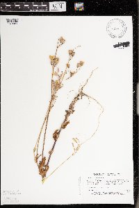 Silene vulgaris subsp. vulgaris (Moench) Garcke 458816[1373929]Puchalski, L. 4301993-08-24 United States, Minnesota, Mahnomen, Mahnomen County...Nelson Prairie WPA. Plants growing on E side of railroad tracks...T146N R42W SE1/4 of NE1/4 of Sec 10;Nelson Prairie / White Earth Indian Reservation;146N;42W;10, 47.477586 -95.986759 |
MIN:Plants | 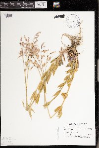 Silene vulgaris subsp. vulgaris (Moench) Garcke 459261[1373930]Puchalski, L. 2441993-06-28 United States, Minnesota, Polk, Polk County...Chicog WMA...S of the entrance to the WMA...T148N R45W NE1/4 of NE1/4 of sec 33;Chicog Wildlife Management Area;148N;45W;33, 47.593704 -96.397789 |
MIN:Plants | 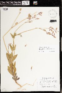 Silene vulgaris subsp. vulgaris (Moench) Garcke 460941[1373925]Puchalski, L. 3571993-08-04 United States, Minnesota, Polk, Polk County...In a ditch on the west side of the county road...T 150N R 39W NW1/4 of NW1/4 of Sec 32;;150N;39W;32, 47.768687 -95.676523 |
MIN:Plants | Silene vulgaris subsp. vulgaris (Moench) Garcke 463419[]Lakela, Olga 144661952-06-30 United States, Minnesota, Saint Louis, St. Louis County...Midway Road near Nopeming;;049N;15W;29, 46.698894 -92.269335 |
MIN:Plants | 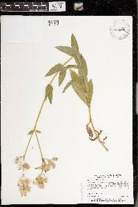 Silene vulgaris subsp. vulgaris (Moench) Garcke 464655[1373931]Myhre, K. 43531993-08-07 United States, Minnesota, Pine, General C C Andrews State Forest. Pine County...Located in the campground on the Willow River near the town of Willow River...T 44N R 20W SE1/4 of NE1/4 of Sec 2. 044N 20W 2, 46.324306 -92.834766 |
MIN:Plants | 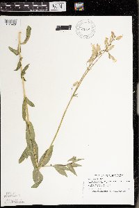 Silene vulgaris subsp. vulgaris (Moench) Garcke 473814[1373928]Smith, Welby 208701992-07-15 United States, Minnesota, Marshall, Marshall County...In Old Mill State Park, about 11 miles east of Argyle...T 156N R 46W NW1/4 of SE1/4 of Sec 4;Old Mill State Park;156N;46W;04, 48.3602791 -96.5702744 |
MIN:Plants | 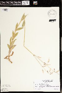 Silene vulgaris subsp. vulgaris (Moench) Garcke 475768[1373933]Rabie, P. 00111996-07-01 United States, Minnesota, Clearwater, Clearwater County...SW SW Sec 1 T142N [should be T143N] R36W; incinerator road.;Itasca State Park;143N;36W;01, 47.232293 -95.180237 |
MIN:Plants |  Silene vulgaris subsp. vulgaris (Moench) Garcke 515143[1373927]Cholewa, A. 25531998-06-23 United States, Minnesota, Aitkin, Aitkin Co.; Soo Line Trail and Co. Road 5, just south of Palisade, T49N, R25W, S27, NE1/4.;;049N;25W;27, 46.70315 -93.495241 |
MIN:Plants | Silene vulgaris subsp. vulgaris (Moench) Garcke 687604[]Wheeler, Gerald; Glaser, Paul 20491977-07-12 United States, Minnesota, Itasca, Itasca County...SE1/4 NW1/4 S26, T55N, R25W; ca 2 mi SE of Grand Rapids, near the Prairie River.;;055N;25W;26, 47.217554 -93.480441 |
MIN:Plants | Silene vulgaris subsp. vulgaris (Moench) Garcke 773237[]Boe, J. 6071979-07-08 United States, Minnesota, Lake of the Woods, Lake of the Woods County...Hwy 2 N of Williams. S24, R34W, T163N.;;163N;34W;24, 48.923417 -94.970989 |
MIN:Plants | Silene vulgaris subsp. vulgaris (Moench) Garcke 773761[]Boe, J. 7571979-07-11 United States, Minnesota, Lake of the Woods, Lake of the Woods County...near Faunce tower. W1/2 S18, R33W, T159N;Beltrami Island State Forest;159N;33W;18, 48.590455 -94.941733 |
MIN:Plants | Silene vulgaris subsp. vulgaris (Moench) Garcke 774088[]Boe, J. 4371979-06-28 United States, Minnesota, Lake of the Woods, Lake of the Woods County...Jnc Hwy 11, 6 near Pitt. NE1/4 S2, R32W, T160N;;160N;32W;02, 48.706763 -94.72529 |
MIN:Plants | Silene vulgaris subsp. vulgaris (Moench) Garcke 800335[]Cholewa, A. 16891989-06-21 United States, Minnesota, Washington, Carpenter Nature Center. Washington Co, T26N R20W S4...S end of rr trail;Carpenter Nature Center;026N;20W;04, 44.768807 -92.813616 |
MIN:Plants |  Silene vulgaris subsp. vulgaris (Moench) Garcke 830007[1373932]Townsend, D.; Cuthrell, Dave 91-2081991-07-14 United States, Minnesota, Marshall, Marshall County...SW1/4 SE1/4 SE1/4 Sec 3 T158N R46W;;158N;46W;03, 48.536418 -96.573219 |
MIN:Plants |  Silene vulgaris subsp. vulgaris (Moench) Garcke 830052[1373934]Boe, J. 920702061992-07-02 United States, Minnesota, Roseau, Roseau County...Gravel pit NE of Greenbush...NE1/4 NW1/4 Sec 22 T161N R42W.;;161N;42W;22, 48.753624 -96.062894 |
MIN:Plants |  Silene vulgaris subsp. vulgaris (Moench) Garcke 831004[1373926]Cholewa, A. 20951992-08-22 United States, Minnesota, Aitkin, Aitkin Co. Sandy River canoe access at Sandy River Flowage Lake, ca. 1.5 mi W of hwy.65 at jnc. with hwy. 6 (N of McGregor). T49N R24W Sec.36 NW1/4.. 049N 24W 36, 46.688354 -93.32778 |
MIN:Plants | Silene vulgaris subsp. vulgaris (Moench) Garcke 913151[]Scott, P. 26442006-08-20 United States, Minnesota, Saint Louis, St. Louis Co. Gravel pit by Echo Trail, SNF. T5N R14W sec. 15 SWSE.;Superior National Forest;065N;14W;15, 48.114873 -92.115914 |
MIN:Plants | Silene vulgaris subsp. vulgaris (Moench) Garcke 930245[]Scott, P. 34742011-08-01 United States, Minnesota, Cook, Gunflint Trail; S of road to Clearwater Lake. Multiple sections: 10, 14, 15. ;Superior National Forest;064N;01W;10, 48.041017 -90.437576 |
MIN:Plants | 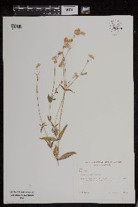 Silene vulgaris (Moench) Garcke 953669[1294520]Bennett, H. R. 2658 United States, Michigan, Cass |
MIN:Plants | 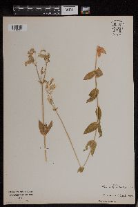 Silene vulgaris (Moench) Garcke 953670[1294521]Anonymous s.n.1894-07-00 United States, Massachusetts, Essex, Marblehead Neck |
MIN:Plants | Silene menziesii Hooker 585848[]Porter, C.; et al. 92271963-06-03 United States, Wyoming, Crook, Crook County. Devil's Tower campground.;Devils Tower National Monument, 1219m |
MIN:Plants | Silene menziesii Hooker 378302[]Goodman, G.; et al. 28291936-06-30 United States, Arizona, Apache, Luka-Chukai Mountains, Apache County;Navaho Indian Reservation, 2727m |
MIN:Plants | Silene menziesii Hooker 540130[]Solheim, W.; et al. 48491957-06-28 United States, Wyoming, Teton, Teton County...Pacific Creek at U.S. Highway 26, Grand Teton National Park.;Grand Teton National Park, 2042m |
MIN:Plants | Silene menziesii Hooker 108149[]Scheuber, E. s.n.1902-07-14 United States, Wyoming, Park, Yellowstone National Park ... Yellowstone Lake;Yellowstone National Park |
MIN:Plants | Silene menziesii Hooker 484875[]Bright, R. 76-721977-00-00 United States, Idaho, Franklin, [no further data] |
MIN:Plants | Silene menziesii Hooker 484874[]Bright, R. 73-2411973-00-00 United States, Idaho, Franklin, [no further data] |
MIN:Plants | Silene menziesii Hooker 427072[]Went, F. s.n.1947-08-23 United States, California, Sky Meadows [assuming CA based on other collections] |
MIN:Plants | Stellaria umbellata Turczaninow 569129[]Hunnewell, F. 121121931-08-10 United States, Colorado, Larimer, Estes Park, Larimer Co. ... Dream Lake;Rocky Mountain National Park |
MIN:Plants | Stellaria umbellata Turczaninow 569204[]Hunnewell, F. 30771914-08-28 United States, Colorado, Larimer, Long's Peak and vicinity. Larimer Co.;Rocky Mountain National Park |
MIN:Plants | Stellaria umbellata Turczaninow 522713[]Cooper, William s.n.1906-09-07 United States, Colorado, Larimer, Wild Basin, Estes Park;Rocky Mountain National Park |
MIN:Plants | Stellaria umbellata Turczaninow 230511[]Congdon, J. s.n.1890-08-12 United States, California, Mariposa, Yosemite National Park. Buck Camp, Mariposa County Leadfield Rd, 3.5 mi SE of Leadfield.. |
MIN:Plants | Cerastium fontanum Baumgarten 919494[]Smith, Welby 222211993-05-25 United States, Minnesota, McLeod, Piepenburg CP. McLeod County ... Piepenberg [sic] County Park, on the east side of Belle Lake about 6 miles northwest of Hutchinson...T117N R30W SE1/4 of NE1/4 of Sec 3. 117N 30W 3, 44.9736111 -94.4211111 |
MIN:Plants | 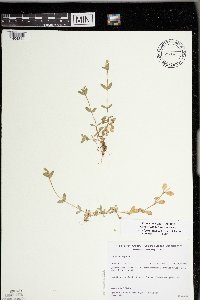 Cerastium fontanum Baumgarten 426830[1404844]Gerdes, Lynden; et al. 26531998-06-09 United States, Minnesota, Cook, Boundary Waters Canoe Area Wilderness / Superior National Forest. T65N R02W S26SESE. Cook County ... Superior National Forest, BWCAW. North of Hoat Lake; drainage feature running alongside the hiking trail.. 065N 02W 26, 48.084268 -90.54412 |
MIN:Plants | Cerastium fontanum Baumgarten 487959[]Mason, Harriet; et al. NSP98-091998-05-13 United States, Minnesota, Rice, SW corner of sec. 16 in Nerstrand Big Woods State Park. North end of west boundary ... Near north tree line.;Nerstrand Woods State Park;110N;19W;16, 44.334371 -93.111203 |
MIN:Plants | 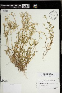 Cerastium fontanum Baumgarten 476217[1404839]Smith, Welby 168991990-06-20 United States, Minnesota, Dodge, Dodge County...Dodge Center Creek Park. On the north side of Dodge Center Creek, and one mile west of the town Center; T 107N R 17W SW1/4 of SW1/4 of Sec 28. 107N 17W 28, 44.040554 -92.8780518 |
MIN:Plants | Cerastium fontanum Baumgarten 478343[]Kaul, R. 73251995-05-26 United States, Minnesota, Steele, Steele County [note: previous collections have been from Owatonna and vicinity];;107N;20W;, 44.066112 -93.226071 |
MIN:Plants | Cerastium fontanum Baumgarten 504034[]Russell, N. 7115351953-07-11 United States, New York, Albany, Albany Co. ... E.N. Huyck Preserve, Rensselaerville ... Lincoln Pond Cottage |
MIN:Plants | Cerastium fontanum Baumgarten 920564[]Smith, Welby 203821992-06-12 United States, Minnesota, Le Sueur, Le Sueur County ... Sakatah Lake State Park; about 2 miles east of Waterville ... T109N R23W NW1/4 of NE1/4 of Sec 25;Sakatah Lake State Park;109N;23W;25, 44.2241667 -93.5294444 |
MIN:Plants | Cerastium fontanum Baumgarten 435262[]Davis, Owen s.n.1978-07-18 United States, Idaho, Cassia, [no further data] |
MIN:Plants | Cerastium fontanum Baumgarten 511153[]Wheeler, Gerald 168451997-07-25 United States, Minnesota, Benton, Benton County ... Ca. 0.7 mi. SSW of Watab on Rte. 55 ... W1/2 NW1/4 SE1/4 Sec. 27 T37N R28W (Watab 27);;037N;28W;27, 45.66981 -93.81245 |
MIN:Plants | Cerastium fontanum Baumgarten 108286[]McDougal, D. 5141892-06-27 United States, Idaho, Latah, Pine Creek, Latah Co. |
MIN:Plants | Cerastium fontanum Baumgarten 489164[]Smith, Welby 157291989-07-17 United States, Minnesota, Benton, Benlacs Wildlife Management Area. Benton County ... Benlacs State Wildlife Management Area, about 7 miles southeast of Foley...SE1/4 SE1/4 section 12, T 36N R 28W. 036N 28W 12, 45.6208344 -93.7630539 |
MIN:Plants | Cerastium fontanum Baumgarten 835981[]Myhre, K. 35561993-05-09 United States, Minnesota, Pine, Pine County ... Located near the public access at Bass Lake ... T43N R21W SW1/4 of SW1/4 of Sec 31;;043N;21W;31, 46.165655 -93.043334 |
MIN:Plants | Cerastium fontanum Baumgarten 835999[]Myhre, K. 35651993-05-11 United States, Minnesota, Pine, Pine County ... Located 4 mi NE of the town of Hinckley ... T 41N R 20W SW1/4 of NW1/4 of Sec 23;Kettle River Scientific Natural Area / Sandstone National Wildlife Refuge;041N;20W;23, 46.018609 -92.835797 |
MIN:Plants | Cerastium fontanum Baumgarten 108427[]Manning, Sara s.n.1878-06-00 United States, Minnesota, Wabasha, Lake City;;111N;12W;, 44.4081 -92.252454 |
MIN:Plants | Cerastium fontanum Baumgarten 108428[]Rosendahl, C. 2301902-05-31 United States, Minnesota, Houston, Spring Grove.;;101N;07W;, 43.543923 -91.6707 |
MIN:Plants | Cerastium fontanum Baumgarten 108429[]Herrick, C. s.n.1878-06-00 United States, Minnesota, Hennepin, Minneapolis;;;;, 44.98 -93.26361 |
MIN:Plants | Cerastium fontanum Baumgarten 108430[]Sheldon, Edmund S1821891-06-00 United States, Minnesota, Blue Earth, Eagle Lake, B.E. Co.;;108N;25W;, 44.152492 -93.828355 |
MIN:Plants | Cerastium fontanum Baumgarten 108431[]Taylor, B. T681891-06-00 United States, Minnesota, Le Sueur, Elysian;;109N;24W;, 44.239498 -93.707142 |
MIN:Plants | Cerastium fontanum Baumgarten 108432[]Herrick, C. 32-131878-08-05 United States, Minnesota, Hennepin, Minnetonka;;117N;22W;, 44.93506 -93.461906 |
MIN:Plants | Cerastium fontanum Baumgarten 108433[]Aiton, G. s.n.1889-08-00 United States, Minnesota, Elwell's bog.;;;;, 46.251401 -94.534576 |
MIN:Plants | Cerastium fontanum Baumgarten 108434[]Ballard, C. B4001891-07-00 United States, Minnesota, Scott, Jordan;;114N;23W;, 44.674435 -93.582701 |
MIN:Plants | Cerastium fontanum Baumgarten 108435[]Herrick, C. s.n.1878-07-00 United States, Minnesota, Hennepin, Minneapolis ... Lake of Isles;;029N;24W;, 44.991926 -93.288153 |
MIN:Plants | Cerastium fontanum Baumgarten 108436[]Ballard, C. B2331891-06-00 United States, Minnesota, Scott, Jordan;;114N;23W;, 44.674435 -93.582701 |
MIN:Plants | Cerastium fontanum Baumgarten 108437[]Ballard, C. B9971892-07-00 United States, Minnesota, Nicollet, Middle Lake, Nicollet Co.;;110N;28W;00, 44.32637 -94.190238 |
MIN:Plants | Cerastium fontanum Baumgarten 108438[]Ballard, C. B5151891-07-00 United States, Minnesota, Scott, Prior Lake. Scott Co.;;115N;22W;, 44.760853 -93.459533 |
MIN:Plants | Cerastium fontanum Baumgarten 108439[]Taylor, B. T2311891-06-00 United States, Minnesota, Waseca, Janesville;;N;;, 44.116078 -93.708004 |
MIN:Plants | Cerastium fontanum Baumgarten 108440[]Kassube, J. s.n.1878-05-00 United States, Minnesota, Hennepin, Minneapolis;;N;;, 44.979965 -93.263836 |
MIN:Plants | Cerastium fontanum Baumgarten 108441[]Roberts, Thomas s.n.1879-08-28 United States, Minnesota, Lake, Beaver Bay;North Shore;055N;07W;12, 47.2577 -91.300444 |
MIN:Plants | Cerastium fontanum Baumgarten 108442[]Aiton, G. s.n.1890-00-00 United States, Minnesota, Hennepin, Minneapolis;;N;;, 44.979965 -93.263836 |
MIN:Plants | Cerastium fontanum Baumgarten 108443[]Sandberg, John s.n.1894-05-00 United States, Minnesota, Hennepin, Vicinity of Minneapolis;;N;;, 44.979965 -93.263836 |
MIN:Plants | Cerastium fontanum Baumgarten 108444[]Sheldon, Edmund s.n.1893-06-00 United States, Minnesota, Lake, Two Harbors;North Shore;052N;11W;, 47.02278 -91.67056 |
MIN:Plants | Cerastium fontanum Baumgarten 108445[]Arthur, J.; et al. B4721886-07-29 United States, Minnesota, Lake, Agate Bay;North Shore;052N;11W;01, 47.01954 -91.67918 |
MIN:Plants | Cerastium fontanum Baumgarten 108447[]Leiberg, John s.n.1883-00-00 United States, Minnesota, Blue Earth, Cold Springs;;N;;, 44.18454 -93.930285 |
MIN:Plants | Cerastium fontanum Baumgarten 225111[]Rosendahl, C.; Butters, F. 4516a1924-07-01 United States, Minnesota, Cook, Along logging road, Caribou River, North Shore Lake Superior.;North Shore / Superior National Forest;060N;03W;, 47.677444 -90.706891 |
MIN:Plants | Cerastium fontanum Baumgarten 262000[]Roberts, Thomas s.n.1925-07-31 United States, Minnesota, Saint Louis, Pine Creek, 6 mi. S of Ely.;Superior National Forest;N;;, 47.816394 -91.867087 |
MIN:Plants | Cerastium fontanum Baumgarten 264446[]Holzinger, John s.n.1905-06-00 United States, Minnesota, Winona, Winona bluffs;;N;;, 44.007012 -91.558291 |
MIN:Plants | Cerastium fontanum Baumgarten 267213[]Stevenson, J. 3671912-08-26 United States, Minnesota, Itasca, Grand Rapids;;055N;25W;, 47.215547 -93.522987 |
MIN:Plants | Cerastium fontanum Baumgarten 267214[]Stevenson, J. 3671912-08-26 United States, Minnesota, Itasca, Grand Rapids;;055N;25W;, 47.215547 -93.522987 |
MIN:Plants | Cerastium fontanum Baumgarten 276129[]Moyle, J. 371930-06-19 United States, Minnesota, Clearwater, Itasca Park, along road, campus; SE1/4 SE1/4 Sec. 2 T143N R36W;Itasca State Park;143N;36W;2, 47.231973 -95.201528 |
Google Map
Google Maps is a web mapping service provided by Google that features a map that users can pan (by dragging the mouse) and zoom (by using the mouse wheel). Collection points are displayed as colored markers that when clicked on, displays the full information for that collection. When multiple species are queried (separated by semi-colons), different colored markers denote each individual species.