University of Minnesota
http://www.umn.edu/
612-625-5000
http://www.umn.edu/
612-625-5000
Minnesota Biodiversity Atlas
Bell Museum
Dataset: MIN-Plants
Taxa: Dryopteris
Search Criteria: excluding cultivated/captive occurrences
Bell Museum plants | |
 MIN:Plants |  Dryopteris fragrans (L.) Schott 459332[1324296]Kukachka, B. 7921937-09-17 United States, Minnesota, Lake, Half-way Station, Lake Co.;;N;;, 47.669689 -91.416748 |
MIN:Plants |  Dryopteris fragrans (L.) Schott 462653[1324197]Lakela, Olga 157241952-09-04 United States, Minnesota, Lake, Hoist Bay at Bass Lake portage, QSWRC [Quetico Superior Wilderness Research Center], Lake Co.;Boundary Waters Canoe Area Wilderness / Superior National Forest;064N;10W;00, 47.669689 -91.416748 |
MIN:Plants | 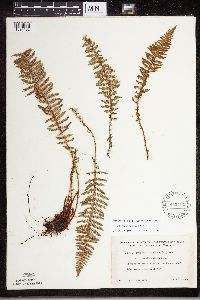 Dryopteris fragrans (L.) Schott 462754[1324182]Lakela, Olga 150871952-07-16 United States, Minnesota, Saint Louis, St. Louis Co. N shore of Kabetogama Lake, Lost Bay;Voyageurs National Park;N;;, 48.59436 -92.981254 |
MIN:Plants | 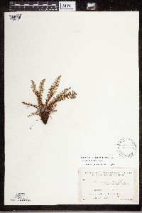 Dryopteris fragrans (L.) Schott 462876[1324171]Lakela, Olga 142411952-06-18 United States, Minnesota, Saint Louis, St. Louis Co. Namakan Lake at the Narrows;Voyageurs National Park;069N;17W;, 48.42805 -92.648654 |
MIN:Plants | 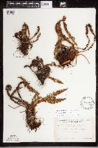 Dryopteris fragrans (L.) Schott 463064[1324190]Lakela, Olga 158931952-10-10 United States, Minnesota, Lake, At Palisade Head, Hwy.61, Lake Co.;North Shore / Palisade Head;056N;07W;22, 47.319363 -91.216275 |
MIN:Plants |  Dryopteris fragrans (L.) Schott 463108[1324181]Lakela, Olga 142821952-06-19 United States, Minnesota, Saint Louis, Rocky Point; S shore of Namakan Lake, St. Louis Co.;Voyageurs National Park;N;;, 48.483546 -92.838098 |
MIN:Plants | 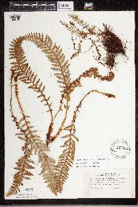 Dryopteris fragrans (L.) Schott 463470[1324168]Lakela, Olga 141311952-06-16 United States, Minnesota, Saint Louis, At Namakan Narrows, St. Louis Co.;Voyageurs National Park;069N;17W;, 48.42805 -92.648654 |
MIN:Plants | 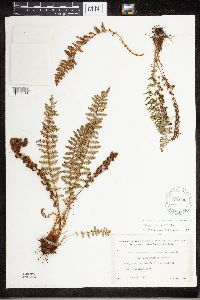 Dryopteris fragrans (L.) Schott 491690[1324283]Lakela, Olga 166061953-08-06 United States, Minnesota, Saint Louis, St. Louis Co. Lac La Croix, S of Lac La Croix Resort;Boundary Waters Canoe Area Wilderness / Superior National Forest;N;;, 48.265868 -92.060542 |
MIN:Plants | 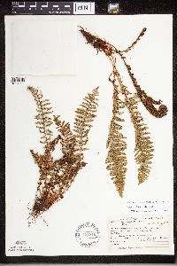 Dryopteris fragrans (L.) Schott 491816[1324290]Lakela, Olga 165091953-08-01 United States, Minnesota, Lake, On Moose Lake. Canadian Border Lodge, Lake Co.;Boundary Waters Canoe Area Wilderness / Superior National Forest;064N;09W;32, 47.583104 -91.421915 |
MIN:Plants | 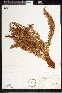 Dryopteris fragrans (L.) Schott 492874[1324289]Lakela, Olga 164161953-07-27 United States, Minnesota, Lake, Lake Co....E shore of Pipestone Bay [Basswood Lake];Boundary Waters Canoe Area Wilderness / Superior National Forest;064N;11W;00, 47.669689 -91.416748 |
MIN:Plants | 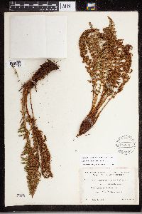 Dryopteris fragrans (L.) Schott 493034[1324198]Lakela, Olga 167071953-08-08 United States, Minnesota, Saint Louis, St. Louis Co. Lac La Croix E of Lac La Croix Resort;Boundary Waters Canoe Area Wilderness / Superior National Forest;N;;, 48.265868 -92.060542 |
MIN:Plants | 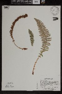 Dryopteris fragrans (L.) Schott 508708[1305889]Lee, Michael MDL11621995-09-20 United States, Minnesota, Pine, Banning State Park. Pine Co. Banning State Park; cliffs along the Kettle River gorge 1 1/4 mi NNE of Sandstone; upper 1/3 of 25m cliffs imme Pine Co. Banning State Park; cliffs along the Kettle River gorge 1 1/4 mi NNE of Sandstone; upper 1/3 of 25m cliffs immediately above the river; T42N R20W NWNWSE 3. 042N 20W 3, 46.148264 -92.857693 |
MIN:Plants | 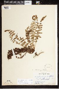 Dryopteris fragrans (L.) Schott 52220[1324298]Rosendahl, C.O. s.n.1918-06-01 United States, Minnesota, Saint Louis, About 10 mi W of Duluth;;N;;, 46.783078 -92.317992 |
MIN:Plants | 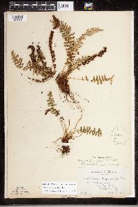 Dryopteris fragrans (L.) Schott 52221[1324195]Lange, D. 161917-07-18 United States, Minnesota, Cook, North Lake, Cook Co.;Boundary Waters Canoe Area Wilderness / Superior National Forest;065N;02W;, 48.112727 -90.565377 |
MIN:Plants | 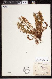 Dryopteris fragrans (L.) Schott 53141[1324212]Arthur, J. B4301886-07-26 United States, Minnesota, Lake, Basswood Lake. Vermilion Lake.;Boundary Waters Canoe Area Wilderness / Superior National Forest;;;, 48.028382 -91.387532 |
MIN:Plants | 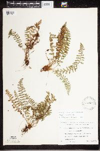 Dryopteris fragrans (L.) Schott 532834[1324284]Lakela, Olga 210381956-08-29 United States, Minnesota, Saint Louis, St. Louis County...along portage creek between Dark and Iron Lakes, just S of Ontario border;Boundary Waters Canoe Area Wilderness / Superior National Forest;066N;13W;11, 48.030785 -92.058533 |
MIN:Plants | 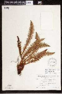 Dryopteris fragrans (L.) Schott 543521[1324196]Lakela, Olga 221681957-08-20 United States, Minnesota, Lake, Lake Co. Endless Waters Trail, Kawishiwi River Range.;Superior National Forest;N;;, 47.669689 -91.416748 |
MIN:Plants | 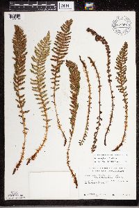 Dryopteris fragrans (L.) Schott 678958[1324183]Ownbey, Gerald 50351975-07-25 United States, Minnesota, Cook, Cook County...Grand Portage. Crest of Mt. Josephine;Grand Portage Indian Reservation / North Shore;064N;06E;34, 47.959234 -89.821113 |
MIN:Plants | 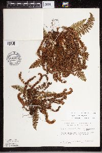 Dryopteris fragrans (L.) Schott 681919[1324218]Clemants, Steven 8011977-08-06 United States, Minnesota, Cook, Cook County...Mouth of Pigeon River...E center of sec.29, T64N, R7E;Grand Portage Indian Reservation / North Shore;064N;07E;29, 47.959234 -89.821113 |
MIN:Plants | 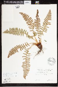 Dryopteris fragrans (L.) Schott 682020[1324286]Herje, S. s.n.1977-05-21 United States, Minnesota, Cook, 1 mi SW of Grand Marais;North Shore / Superior National Forest;061N;01E;, 47.740211 -90.349495 |
MIN:Plants | 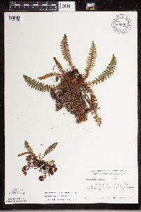 Dryopteris fragrans (L.) Schott 684835[1324205]Meyer, Rob 221977-08-06 United States, Minnesota, Cook, Cook Co. N side of Pigeon Point. NW1/4 Sec.27 T64N R7E.;Grand Portage Indian Reservation / North Shore;064N;07E;27, 47.959234 -89.821113 |
MIN:Plants | 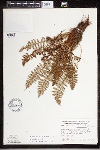 Dryopteris fragrans (L.) Schott 709466[1324206]Wheeler, Gerald 44601979-07-21 United States, Minnesota, Cook, Cook Co. Kodunce River State Park. About 9 mi NE of Grand Marais on Rte. 61. T61N R2E Sec.2.;North Shore / Superior National Forest;061N;02E;2, 47.828174 -90.218584 |
MIN:Plants | 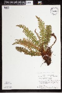 Dryopteris fragrans (L.) Schott 723844[1324220]Smith, Welby 26121980-06-22 United States, Minnesota, Cook, SE end of Lucille Island, in the Susie Island system; Lake Superior.;North Shore / Susie Islands, The Nature Conservancy;063N;07E;, 47.9652786 -89.5688858 |
MIN:Plants | 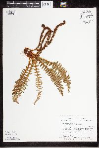 Dryopteris fragrans (L.) Schott 723845[1324281]Smith, Welby 26121980-06-22 United States, Minnesota, Cook, SE end of Lucille Iisland, in the Susie Island system; Lake Superior.;North Shore / Susie Islands, The Nature Conservancy;063N;07E;, 47.9652786 -89.5688858 |
MIN:Plants |  Dryopteris fragrans (L.) Schott 723867[1324221]Smith, Welby 25931980-06-22 United States, Minnesota, Cook, NW side of Lucille Island, in the Susie Island system; Lake Superior.;North Shore / Susie Islands, The Nature Conservancy;063N;07E;, 47.9630547 -89.5849991 |
MIN:Plants |  Dryopteris fragrans (L.) Schott 724340[1324285]Smith, Welby 26121980-06-22 United States, Minnesota, Cook, SE end of Lucille Island, in the Susie Island system; Lake Superior.;North Shore / Susie Islands, The Nature Conservancy;063N;07E;, 47.9652786 -89.5688858 |
MIN:Plants |  Dryopteris fragrans (L.) Schott 727486[1324222]Smith, Welby 26061980-06-21 United States, Minnesota, Cook, At the western-most tip of Magnet Island, in the Susie Island system; Lake Superior.;North Shore / Susie Islands, The Nature Conservancy;063N;07E;, 47.9708328 -89.5616684 |
MIN:Plants | 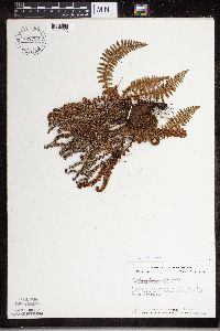 Dryopteris fragrans (L.) Schott 728732[1324223]Coffin, Barbara 311980-08-23 United States, Minnesota, Cook, Cook Co. Overlooking small pond S of Pemmican Lake S of E end of Mountain Lake. T65N R2E; SW1/4 NE1/4 Sec. 22.;Boundary Waters Canoe Area Wilderness / Superior National Forest;065N;02E;22, 48.10737 -90.224172 |
MIN:Plants | 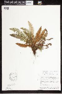 Dryopteris fragrans (L.) Schott 795926[1324292]Smith, Welby 119041986-06-25 United States, Minnesota, Cook, Cook Co. Cliff overlooking Clearwater Lake in the BWCA. NE1/4 SW1/4 sec.28, T65N R1E;Boundary Waters Canoe Area Wilderness / Superior National Forest;065N;01E;28, 48.087449 -90.322587 |
MIN:Plants |  Dryopteris fragrans (L.) Schott 802766[1324282]Smith, Welby 118741986-06-24 United States, Minnesota, Cook, Boundary Waters Canoe Area Wilderness / Superior National Forest. Cook Co. In the Boundary Waters Canoe Area of the Superior National Forest; near the W end of Mountain Lake. NW1/4 SE1/4 Cook Co. In the Boundary Waters Canoe Area of the Superior National Forest; near the W end of Mountain Lake. NW1/4 SE1/4 sec.23, T65N R1E. T065N R01E S23, 48.096403 -90.291084 |
MIN:Plants | 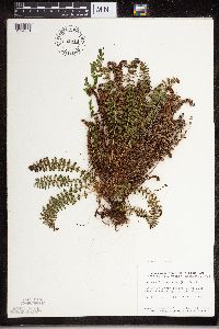 Dryopteris fragrans (L.) Schott 802916[1324201]Smith, Welby 118871986-06-24 United States, Minnesota, Cook, Cook Co. Cliff overlooking Watap Lake in the BWCA. SW1/4 NE1/4 sec.21, T65N R1E;Boundary Waters Canoe Area Wilderness / Superior National Forest;065N;01E;21, 48.10737 -90.224172 |
MIN:Plants | 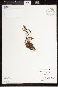 Dryopteris fragrans (L.) Schott 817770[1324219]Berlin, N. 322a1980-09-05 United States, Minnesota, Cook, Cook Co, Susie Island Archipelago, NE end of Luciile Island.;North Shore / Susie Islands, The Nature Conservancy;063N;07E;, 47.973776 -89.578978 |
MIN:Plants | 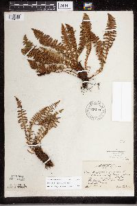 Dryopteris fragrans (L.) Schott 820093[1324175]Lakela, Olga 28081938-09-18 United States, Minnesota, Saint Louis, Above Haines road at Skyline Parkway 40th Ave. W; Duluth.;;N;;, 46.759628 -92.164757 |
MIN:Plants | Dryopteris goldiana (Hooker ex Goldie) A. Gray 298046[1324345;1326810]Myhre, K. United States, Minnesota, Cass, Detailed locality information protected. This is typically done to protect rare or threatened species localities. |
MIN:Plants | Dryopteris goldiana (Hooker ex Goldie) A. Gray 381541[1324343]Rosendahl, C. United States, Minnesota, Olmsted, Detailed locality information protected. This is typically done to protect rare or threatened species localities. |
MIN:Plants | Dryopteris goldiana (Hooker ex Goldie) A. Gray 385557[1324327;1326787]Myhre, K. United States, Minnesota, Cass, Detailed locality information protected. This is typically done to protect rare or threatened species localities. |
MIN:Plants | Dryopteris goldiana (Hooker ex Goldie) A. Gray 432796[1305898]Harris, Fred United States, Minnesota, Olmsted, Detailed locality information protected. This is typically done to protect rare or threatened species localities. |
MIN:Plants | Dryopteris goldiana (Hooker ex Goldie) A. Gray 432806[1324354]Maxson, George-Ann United States, Minnesota, Itasca, Detailed locality information protected. This is typically done to protect rare or threatened species localities. |
MIN:Plants | Dryopteris goldiana (Hooker ex Goldie) A. Gray 439393[1324356]Zager, S. United States, Minnesota, Houston, Detailed locality information protected. This is typically done to protect rare or threatened species localities. |
MIN:Plants | Dryopteris goldiana (Hooker ex Goldie) A. Gray 440526[1324355]Lee, Michael United States, Minnesota, Winona, Detailed locality information protected. This is typically done to protect rare or threatened species localities. |
MIN:Plants | Dryopteris goldiana (Hooker ex Goldie) A. Gray 440682[1305897]Lee, Michael United States, Minnesota, Wabasha, Detailed locality information protected. This is typically done to protect rare or threatened species localities. |
MIN:Plants | Dryopteris goldiana (Hooker ex Goldie) A. Gray 440722[1324329]Smith, Welby United States, Minnesota, Fillmore, Detailed locality information protected. This is typically done to protect rare or threatened species localities. |
MIN:Plants | Dryopteris goldiana (Hooker ex Goldie) A. Gray 441720[1324323]Lee, Michael United States, Minnesota, Fillmore, Detailed locality information protected. This is typically done to protect rare or threatened species localities. |
MIN:Plants | Dryopteris goldiana (Hooker ex Goldie) A. Gray 443799[1324320]Harris, Fred United States, Minnesota, Olmsted, Detailed locality information protected. This is typically done to protect rare or threatened species localities. |
MIN:Plants | Dryopteris goldiana (Hooker ex Goldie) A. Gray 456281[1305905]Lee, Michael United States, Minnesota, Fillmore, Detailed locality information protected. This is typically done to protect rare or threatened species localities. |
MIN:Plants | Dryopteris goldiana (Hooker ex Goldie) A. Gray 457167[1305906]Lee, Michael United States, Minnesota, Fillmore, Detailed locality information protected. This is typically done to protect rare or threatened species localities. |
MIN:Plants | Dryopteris goldiana (Hooker ex Goldie) A. Gray 459096[1305904]Lee, Michael United States, Minnesota, Fillmore, Detailed locality information protected. This is typically done to protect rare or threatened species localities. |
MIN:Plants | Dryopteris goldiana (Hooker ex Goldie) A. Gray 459671[1324322]Harris, Fred United States, Minnesota, Detailed locality information protected. This is typically done to protect rare or threatened species localities. |
MIN:Plants | Dryopteris goldiana (Hooker ex Goldie) A. Gray 475574[1324344]Dunevitz, H. United States, Minnesota, Winona, Detailed locality information protected. This is typically done to protect rare or threatened species localities. |
MIN:Plants | Dryopteris goldiana (Hooker ex Goldie) A. Gray 484590[1324314]Lee, Michael United States, Minnesota, Wabasha, Detailed locality information protected. This is typically done to protect rare or threatened species localities. |
MIN:Plants | Dryopteris goldiana (Hooker ex Goldie) A. Gray 484850[1305903]Lee, Michael United States, Minnesota, Fillmore, Detailed locality information protected. This is typically done to protect rare or threatened species localities. |
MIN:Plants | Dryopteris goldiana (Hooker ex Goldie) A. Gray 506128[1324351;1326814]Zager, S. United States, Minnesota, Fillmore, Detailed locality information protected. This is typically done to protect rare or threatened species localities. |
MIN:Plants | Dryopteris goldiana (Hooker ex Goldie) A. Gray 508346[1324336]Smith, Welby United States, Minnesota, Fillmore, Detailed locality information protected. This is typically done to protect rare or threatened species localities. |
MIN:Plants | Dryopteris goldiana (Hooker ex Goldie) A. Gray 514478[1324347]Zager, S. United States, Minnesota, Fillmore, Detailed locality information protected. This is typically done to protect rare or threatened species localities. |
MIN:Plants | Dryopteris goldiana (Hooker ex Goldie) A. Gray 516007[1305901]Zager, S. United States, Minnesota, Fillmore, Detailed locality information protected. This is typically done to protect rare or threatened species localities. |
MIN:Plants | Dryopteris goldiana (Hooker ex Goldie) A. Gray 516194[1324349]Lee, Michael United States, Minnesota, Fillmore, Detailed locality information protected. This is typically done to protect rare or threatened species localities. |
MIN:Plants | Dryopteris goldiana (Hooker ex Goldie) A. Gray 519001[1324337]Smith, Welby United States, Minnesota, Houston, Detailed locality information protected. This is typically done to protect rare or threatened species localities. |
MIN:Plants | Dryopteris goldiana (Hooker ex Goldie) A. Gray 519639[1324348]Zager, S. United States, Minnesota, Fillmore, Detailed locality information protected. This is typically done to protect rare or threatened species localities. |
MIN:Plants | Dryopteris goldiana (Hooker ex Goldie) A. Gray 52040[1324330]Leiberg, John United States, Minnesota, Blue Earth, Detailed locality information protected. This is typically done to protect rare or threatened species localities. |
MIN:Plants | Dryopteris goldiana (Hooker ex Goldie) A. Gray 52235[1324315]Lyon, H. United States, Minnesota, Houston, Detailed locality information protected. This is typically done to protect rare or threatened species localities. |
MIN:Plants | Dryopteris goldiana (Hooker ex Goldie) A. Gray 52236[1324331]Sheldon, Edmund United States, Minnesota, Blue Earth, Detailed locality information protected. This is typically done to protect rare or threatened species localities. |
MIN:Plants | Dryopteris goldiana (Hooker ex Goldie) A. Gray 529178[1324326;1326786]Myhre, K. United States, Minnesota, Cass, Detailed locality information protected. This is typically done to protect rare or threatened species localities. |
MIN:Plants | Dryopteris goldiana (Hooker ex Goldie) A. Gray 662459[1324328;1326792]Trana, Thomas United States, Minnesota, Cass, Detailed locality information protected. This is typically done to protect rare or threatened species localities. |
MIN:Plants | Dryopteris goldiana (Hooker ex Goldie) A. Gray 691441[1324333]Ownbey, Gerald United States, Minnesota, Cass, Detailed locality information protected. This is typically done to protect rare or threatened species localities. |
MIN:Plants | Dryopteris goldiana (Hooker ex Goldie) A. Gray 717208[1324334]Peck, J. United States, Minnesota, Fillmore, Detailed locality information protected. This is typically done to protect rare or threatened species localities. |
MIN:Plants | Dryopteris goldiana (Hooker ex Goldie) A. Gray 717214[1324332;1326795]Peck, J. United States, Minnesota, Wabasha, Detailed locality information protected. This is typically done to protect rare or threatened species localities. |
MIN:Plants | Dryopteris goldiana (Hooker ex Goldie) A. Gray 717233[1324342]Peck, J. United States, Minnesota, Winona, Detailed locality information protected. This is typically done to protect rare or threatened species localities. |
MIN:Plants | Dryopteris goldiana (Hooker ex Goldie) A. Gray 722201[1324313]Cushing, E. United States, Minnesota, Hennepin, Detailed locality information protected. This is typically done to protect rare or threatened species localities. |
MIN:Plants | Dryopteris goldiana (Hooker ex Goldie) A. Gray 722203[1324339]Cushing, E. United States, Minnesota, Olmsted, Detailed locality information protected. This is typically done to protect rare or threatened species localities. |
MIN:Plants | Dryopteris goldiana (Hooker ex Goldie) A. Gray 723723[1324341]Woolsey, Henry United States, Minnesota, Winona, Detailed locality information protected. This is typically done to protect rare or threatened species localities. |
MIN:Plants | Dryopteris goldiana (Hooker ex Goldie) A. Gray 723728[1324338]Woolsey, Henry United States, Minnesota, Houston, Detailed locality information protected. This is typically done to protect rare or threatened species localities. |
MIN:Plants | Dryopteris goldiana (Hooker ex Goldie) A. Gray 741631[1324312]Myhre, K. United States, Minnesota, Cass, Detailed locality information protected. This is typically done to protect rare or threatened species localities. |
MIN:Plants | Dryopteris goldiana (Hooker ex Goldie) A. Gray 782378[1324335]Tenney, M. United States, Minnesota, Fillmore, Detailed locality information protected. This is typically done to protect rare or threatened species localities. |
MIN:Plants | Dryopteris goldiana (Hooker ex Goldie) A. Gray 829478[1305902]Zager, S. United States, Minnesota, Houston, Detailed locality information protected. This is typically done to protect rare or threatened species localities. |
MIN:Plants | Dryopteris goldiana (Hooker ex Goldie) A. Gray 829494[1324346]Zager, S. United States, Minnesota, Houston, Detailed locality information protected. This is typically done to protect rare or threatened species localities. |
MIN:Plants | Dryopteris goldiana (Hooker ex Goldie) A. Gray 829495[1305900]Zager, S. United States, Minnesota, Houston, Detailed locality information protected. This is typically done to protect rare or threatened species localities. |
MIN:Plants | Dryopteris goldiana (Hooker ex Goldie) A. Gray 833296[1324319]Juhnke, C. United States, Minnesota, Fillmore, Detailed locality information protected. This is typically done to protect rare or threatened species localities. |
MIN:Plants | Dryopteris goldiana (Hooker ex Goldie) A. Gray 833850[1324316]Smith, Welby United States, Minnesota, Fillmore, Detailed locality information protected. This is typically done to protect rare or threatened species localities. |
MIN:Plants | Dryopteris goldiana (Hooker ex Goldie) A. Gray 834098[1324318]Smith, Welby United States, Minnesota, Olmsted, Detailed locality information protected. This is typically done to protect rare or threatened species localities. |
MIN:Plants | Dryopteris goldiana (Hooker ex Goldie) A. Gray 840363[1324340]Smith, Welby United States, Minnesota, Washington, Detailed locality information protected. This is typically done to protect rare or threatened species localities. |
MIN:Plants | Dryopteris goldiana (Hooker ex Goldie) A. Gray 842873[1324357]Lee, Michael United States, Minnesota, Wabasha, Detailed locality information protected. This is typically done to protect rare or threatened species localities. |
MIN:Plants | Dryopteris goldiana (Hooker ex Goldie) A. Gray 842893[1324358]Lee, Michael United States, Minnesota, Wabasha, Detailed locality information protected. This is typically done to protect rare or threatened species localities. |
MIN:Plants | Dryopteris goldiana (Hooker ex Goldie) A. Gray 842912[1324359]Lee, Michael United States, Minnesota, Wabasha, Detailed locality information protected. This is typically done to protect rare or threatened species localities. |
MIN:Plants |  Dryopteris intermedia (Muhlenberg ex Willdenow) A. Gray 353888[1324379]Lakela, Olga 28071938-09-18 United States, Minnesota, Saint Louis, Above Haines Rd, at Skyline Parkway, 40th Ave W, Duluth;;N;;, 46.759628 -92.164757 |
MIN:Plants | 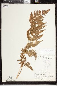 Dryopteris x triploidea Wherry 356577[1324409]Rosendahl, C.O. s.n.1918-08-00 United States, Minnesota, Saint Louis, Duluth, St. Louis County;;;;, 46.783273 -92.106579 |
MIN:Plants | 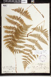 Dryopteris intermedia (Muhlenberg ex Willdenow) A. Gray 357521[1324392]Rosendahl, C.O. 62871930-08-26 United States, Minnesota, Cook, E of Grand Portage, Cook Co.;Grand Portage Indian Reservation / North Shore;063N;06E;, 47.959234 -89.821113 |
MIN:Plants | 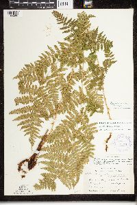 Dryopteris x triploidea Wherry 387515[1324406]Lakela, Olga 60701945-07-21 United States, Minnesota, Lake, Lake County...Beaver Island in Lake Superior, East Beaver Bay;North Shore;055N;07W;05, 47.2677 -91.282943 |
MIN:Plants | 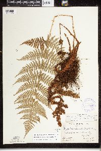 Dryopteris intermedia (Muhlenberg ex Willdenow) A. Gray 387516[1324393]Butters, F.K. 7141940-07-05 United States, Minnesota, Cook, Cook Co. W of Morrison Bay, Pigeon Point, T64N R7E;Grand Portage Indian Reservation / North Shore;064N;07E;, 47.959234 -89.821113 |
MIN:Plants | 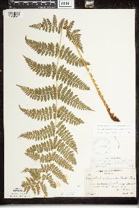 Dryopteris intermedia (Muhlenberg ex Willdenow) A. Gray 387517[1324389]Butters, F.K. 1961936-06-30 United States, Minnesota, Cook, Cook Co. NW of Mineral Center, T63N R5E;Grand Portage Indian Reservation / North Shore;063N;05E;, 47.959234 -89.821113 |
MIN:Plants | 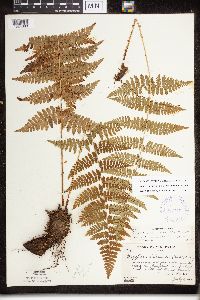 Dryopteris intermedia (Muhlenberg ex Willdenow) A. Gray 387518[1324390]Butters, F.K. 7681944-07-27 United States, Minnesota, Cook, Cook Co. Along the Gunflint Trail about 10 mi N of Grand Marais, T62N R1E;Superior National Forest;062N;01E;, 48.113086 -90.82588 |
MIN:Plants | 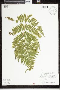 Dryopteris intermedia (Muhlenberg ex Willdenow) A. Gray 426840[1324398;1326853]Myhre, K. 47721994-05-19 United States, Minnesota, Itasca, Itasca Co.; located 1 mi E of Decker Lake; T148N R29W SW1/4 of SE1/4 of Sec 8;Chippewa National Forest;148N;29W;8, 47.646168 -94.378435 |
MIN:Plants | 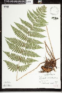 Dryopteris intermedia (Muhlenberg ex Willdenow) A. Gray 439637[1324373;1326834]Myhre, K. 42521993-07-23 United States, Minnesota, Pine, Pine County ... Located 5.5 mi SE of the town of Nickerson ... T45N R16W NE1/4 of SE1/4 of Sec 30;Nemadji State Forest;045N;16W;30, 46.352431 -92.415181 |
MIN:Plants |  Dryopteris intermedia (Muhlenberg ex Willdenow) A. Gray 439646[1324388;1326843]Myhre, K. 35311993-05-06 United States, Minnesota, Pine, Banning State Park. Pine County ... Located less than 1 mi N of the town of Sandstone, in the vicinity of the bat hibernacleum escarpments of the Kettle River ... T42N R20W NW1/4 of NW1/4 of SEc 10. 042N 20W 10, 46.145255 -92.860815 |
MIN:Plants |  Dryopteris intermedia (Muhlenberg ex Willdenow) A. Gray 439759[1305909]Myhre, K. 15891992-04-26 United States, Minnesota, Cass, Cass Co. One half mi S of Lake Winnibigoshish, and W of fish hatchery ponds; T146N R27W NE1/4 of NE1/4 of Sec 35;Chippewa National Forest / Leech Lake Indian Reservation;146N;27W;35, 47.42381 -94.059012 |
MIN:Plants | 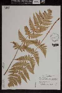 Dryopteris intermedia (Muhlenberg ex Willdenow) A. Gray 440419[1305911]Myhre, K. 15891992-04-26 United States, Minnesota, Cass, Cass Co. 1/2 mi S of Lake Winnibigoshish and W of fish hatchery ponds; T146N R27W NE1/4 of NE1/4 of Sec.35;Chippewa National Forest / Leech Lake Indian Reservation;146N;27W;35, 47.337859 -94.185529 |
MIN:Plants | 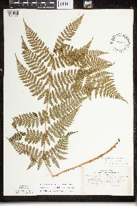 Dryopteris intermedia (Muhlenberg ex Willdenow) A. Gray 443087[1324377]Lakela, Olga 136991951-09-02 United States, Minnesota, Saint Louis, Pike Lake, #53, N of Duluth;;N;;, 46.85 -92.3 |
MIN:Plants | 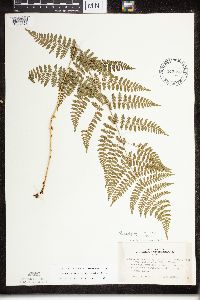 Dryopteris intermedia (Muhlenberg ex Willdenow) A. Gray 443088[1324378]Lakela, Olga 137001951-09-02 United States, Minnesota, Saint Louis, Pike Lake, #53, N of Duluth;;N;;, 46.85 -92.3 |
MIN:Plants | 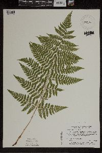 Dryopteris intermedia (Muhlenberg ex Willdenow) A. Gray 455816[1305907]Myhre, K. 33751992-09-30 United States, Minnesota, Cass, Cass Co.; located on Ottertail Peninsula in Leech Lake; T 143N R 30W NW1/4 of NE1/4 of Sec 12;Chippewa National Forest / Leech Lake Indian Reservation;143N;30W;12, 47.22017 -94.417072 |
MIN:Plants | 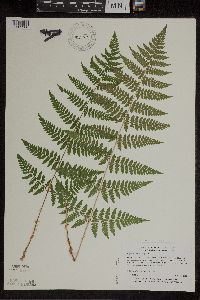 Dryopteris intermedia (Muhlenberg ex Willdenow) A. Gray 455915[1305908]Myhre, K. 52611994-08-04 United States, Minnesota, Saint Louis, St. Louis Co.; located 20 miles north of the town of Two Harbors; T 56N R 10W NW1/4 of SE1/4 of Sec 32;Superior National Forest;056N;10W;32, 48.030785 -92.058533 |
MIN:Plants | 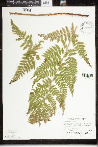 Dryopteris intermedia (Muhlenberg ex Willdenow) A. Gray 514364[1324386]Myhre, K. 4772A1994-05-19 United States, Minnesota, Itasca, Itasca Co.; located 1 miles east of Decker Lake; T 148N R 29W SW1/4 of SE1/4 of Sec 8;Chippewa National Forest;148N;29W;8, 47.64611 -94.378092 |
Google Map
Google Maps is a web mapping service provided by Google that features a map that users can pan (by dragging the mouse) and zoom (by using the mouse wheel). Collection points are displayed as colored markers that when clicked on, displays the full information for that collection. When multiple species are queried (separated by semi-colons), different colored markers denote each individual species.