University of Minnesota
http://www.umn.edu/
612-625-5000
http://www.umn.edu/
612-625-5000
Minnesota Biodiversity Atlas
Bell Museum
Dataset: MIN-Plants
Taxa: Equisetaceae
Search Criteria: excluding cultivated/captive occurrences
Bell Museum plants | |
 MIN:Plants |  508802[1326991]Nation, R. 94-0731994-06-08 United States, Minnesota, Mower, Lake Louise State Park. Mower County...Tract #3A. T101N R14W NW1/4 of SW1/4 of Sec. 21;Lake Louise State Park;101N;14W;21, 43.536579 -92.51252 |
MIN:Plants |  730495[1331246]Cross-Cella, J. 1311980-06-16 United States, Minnesota, Wilkin, Wilkin County...Western Prairie North: 8 mi north of Rothsay. SE1/4 NE1/4 Sec.17, T136N, R45W;Western Prairie North, The Nature Conservancy;136N;45W;17, 46.59752 -96.293735 |
MIN:Plants |  734441[1326993]Cross-Cella, J. 521980-06-05 United States, Minnesota, Becker, Becker County...Green Water Lake Natural Area: 5 mi W of Ponsford. SE1/4 Sec.34, T141N, R38W;Greenwater Lake Scientific Natural Area / White Earth Indian Reservation;141N;38W;34, 46.982137 -95.505425 |
MIN:Plants |  834884[1331247]Cholewa, A. 23441995-07-10 United States, Minnesota, Stearns, Stearns Co. Paynesville, Highgrove BioReserve, just S of Koronis Hills Golf Course, T122N R32W S20;;122N;32W;20, 45.362225 -94.732288 |
MIN:Plants |  907194[1331111]Smith, Welby 309642008-07-02 United States, Minnesota, Saint Louis, St. Louis County...At the SE tip of Coe Lake, about 11 miles southeast of Gilbert...T57N R16W SW1/4 of SW1/4 of Sec 36;;057N;16W;36, 47.3741667 -92.3213889 |
MIN:Plants |  907141[1331307]Smith, Welby 285762000-06-16 United States, Minnesota, Marshall, Thief Lake Wildlife Management Area. Marshall County...Thief Lake State Wildlife Management Area; about 5 miles NE of Gatzke...T158N R39W NW1/4 of SW1/4 of Sec 19. 158N 39W 19, 48.4877778 -95.7297222 |
MIN:Plants |  475235[1331372]Juhnke, C. 254 CMJ FRO1999-05-19 United States, Minnesota, Goodhue, Frontenac State Park Goodhue County ... south of interpretive area ... T112N R13W SE NE SE 3;Frontenac State Park;112N;13W;03, 44.534992 -92.358902 |
MIN:Plants |  907109[1331057]Smith, Welby 284832000-05-31 United States, Minnesota, Houston, Houston County...About 3 miles south of Houston...T 103N R 6W NW1/4 of NE1/4 of Sec 16;Dorer Memorial Hardwood State Forest;103N;06W;16, 43.7316667 -91.5583333 |
MIN:Plants |  907253[1331117]Smith, Welby 285602000-06-16 United States, Minnesota, Red Lake, Crane Wildlife Management Area (Red Lake County). Red Lake County ... North end of Crane State Wildlife Management Area, about 8 miles northeast of Oklee ... T151N R40W NE1/4 of NW1/4 of Sec 13. 151N 40W 13, 47.9047222 -95.7236111 |
MIN:Plants |  911205[1331006]Smith, Welby 288192000-07-26 United States, Minnesota, Aitkin, Aitkin County...Savanna Portage State Park; about one mile west of Shumway Lake...T 50N R 22W SW1/4 of SE1/4 of Sec 7;Savanna Portage State Park;050N;22W;07, 46.8286111 -93.1744444 |
MIN:Plants |  490603[1331248]Juhnke, C. 507 CMJ FRO1999-08-05 United States, Minnesota, Goodhue, Frontenac State Park. Goodhue County ... along the way to Sand Point ... T112N R13W SE SW SE 12;Frontenac State Park;112N;13W;12, 44.519464 -92.318462 |
MIN:Plants |  917013[1326958]Smith, Welby 314802009-09-12 United States, Minnesota, Cook, Boundary Waters Canoe Area Wilderness / Superior National Forest. Cook County...Boundary Waters Canoe Area Wilderness, Superior National Forest...north side of John Lake. T 65N R 3E SW1/4 of NE1/4 of Sec 33. 065N 03E 33, 48.0744444 -90.0633333 |
MIN:Plants |  435887[1331212]Smith, Michael 2501996-08-29 United States, Minnesota, Koochiching, Kabetogama State Forest. Voyagerus National Park. Koochiching Co.; Plot name: Voya 32 DNR #5790; 48 32'02' N 93 13'27'W [this locale is not within the Park boundaries]. 071N 22W, 48.5338898 -93.2241669 |
MIN:Plants |  907107[1331034]Smith, Welby 28460A2000-05-20 United States, Minnesota, Olmsted, Olmsted County...About 3 miles northwest of Rochester...T107N R14W NE1/4 of NE1/4 of Sec 7;;107N;14W;07, 44.0916667 -92.5402778 |
MIN:Plants |  909898[1331044]Smith, Welby 284112000-05-05 United States, Minnesota, Koochiching, Koochiching County...About 1.5 miles W-SW of Northome...T 151N R 29W NW1/4 of SW1/4 of Sec 25;;151N;29W;25, 47.8677778 -94.3091667 |
MIN:Plants |  911198[1331040]Smith, Welby 285212000-06-15 United States, Minnesota, Otter Tail, Glendalough State Park. Otter Tail County...On the west side of Annie Battle Lake, in Glendalough State Park...T 133N R 40W NE1/4 of SW1/4 of Sec 13. 133N 40W 13, 46.3305556 -95.6663889 |
MIN:Plants |  906956[1331058]Smith, Welby 308982008-06-12 United States, Minnesota, Morrison, Rice-Skunk Lake Wildlife Management Area. Morrison County...Rice-Skunk Lake State Wildlife Management Area, about 7 miles southeast of Little Falls...T 40N R 31W SE1/4 of NW1/4 of Sec 32. 040N 31W 32, 45.9222222 -94.2344444 |
MIN:Plants |  911547[1326977]Smith, Welby 285812000-06-16 United States, Minnesota, Marshall, Marshall County...Agassiz National Wildlife Refuge...T 156N R 42W SE1/4 of SE1/4 of Sec 34;Agassiz National Wildlife Refuge;156N;42W;34, 48.2863889 -96.0266667 |
MIN:Plants |  907608[1326975]Smith, Welby 286902000-07-11 United States, Minnesota, Aitkin, Aitkin County...Rice Lake National Wildlife Refuge; about 5 miles SW of McGregor...T 47N R 24W SE1/4 of SW1/4 of Sec 23;Rice Lake National Wildlife Refuge;047N;24W;23, 46.5388889 -93.3422222 |
MIN:Plants |  918176[1331114]Gerdes, Lynden 59642009-08-22 United States, Minnesota, Cook, Boundary Waters Canoe Area Wilderness / Superior National Forest. T66N R05W S34 NWSWNW Cook County ... Superior National Forest. Boundary Waters Canoe Area Wilderness. Red Rock Lake. At drainage.. 066N 05W 34, 48.156695 -90.955168 |
MIN:Plants |  439049[1305936]Gerdes, Lynden 34001999-06-06 United States, Minnesota, Cook, Superior National Forest. T65N R01W S31NENW. Cook County...Superior National Forest. East of East Otter Lake adjacent to a long, open wetland/stream.. 065N 01W 31, 47.991796 -89.998638 |
MIN:Plants |  911554[1331206]Smith, Welby 287162000-07-12 United States, Minnesota, Mille Lacs, Mille Lacs County...Mille Lacs Kathio State Park, about 8 miles northwest of Onamia...T 42N R 27W SW1/4 of SE1/4 Sec 5;Mille Lacs Kathio State Park;042N;27W;05, 46.1286111 -93.7725 |
MIN:Plants |  663836[1333643]Noble, Mark 1571974-07-24 United States, Alaska, Bartlett Cove.;Glacier Bay National Park;;;, 58.449279 -135.89734 |
MIN:Plants |  904527[1326995]Smith, Welby 281871999-08-24 United States, Minnesota, Aitkin, Aitkin County...2.5 miles N-NW of Pliny...T 45N R 23W SW1/4 of NE1/4 of Sec 20;Solana State Forest;045N;23W;20, 46.3597222 -93.2797222 |
MIN:Plants | 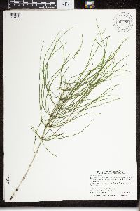 911552[1326976]Smith, Welby 289292000-08-08 United States, Minnesota, Lake, Lake County...Tettegouche State Park, about one mile west of Illgen City...T 56N R 7W NW1/4 of SE1/4 of Sec 10;North Shore / Tettegouche State Park;056N;07W;10, 47.3463889 -91.205 |
MIN:Plants | 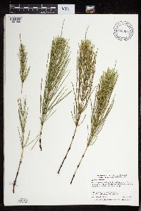 910990[1331209]Smith, Welby 284332000-05-24 United States, Minnesota, Itasca, Chippewa National Forest. Itasca County...Along Hwy 38, 0.5 mile south of jct with county road 49; about 5 miles south of Marcell...T 58N R26W SW1/4 of SE1/4 of Sec 4. 058N 26W 4, 47.5327778 -93.6466667 |
MIN:Plants | 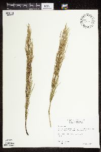 511515[1331068]Wheeler, Gerald 163851997-06-30 United States, Minnesota, Swift, Swift County ... Ca. 9.1 mi. W of Kerkhoven on Rte. 6, 2.1 mi. W of jct. of Rte. 6 and Rte. 31, S of road ... NE1/4 NE1/4 NE1/4 Sec. 23 T120N R39W (Cashel 23). 120N 39W 23, 45.187887 -95.541353 |
MIN:Plants | 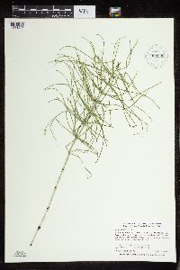 909905[1331207]Smith, Welby 287922000-07-22 United States, Minnesota, Anoka, Anoka County...In the City of Blaine, just south of 95th street and east of I35W...T 31N R 23W SW1/4 of SW1/4 of Sec 26;;031N;23W;26, 45.14 -93.1713889 |
MIN:Plants |  361155[1333772]Ewan, J. 106071937-07-19 United States, Washington, Pierce, Pierce County...Kautz Creek drainage, Rainier Nat. Park;Mount Rainier National Park, 1219m |
MIN:Plants |  643840[1333700]Ahles, H. 763831971-05-05 United States, New Hampshire, Hampshire, Hampshire County ... vicinity of Northampton Resevoir on Resevoir Road, Haydenville |
MIN:Plants |  907139[1331306]Smith, Welby 285712000-06-16 United States, Minnesota, Pennington, Oriniak Wildlife Management Area. Pennington County...Oriniak State Wildlife Management Area about 12 miles SE of Thief River Falls...T 152N R 41W SE1/4 of SE1/4 of Sec 18. 152N 41W 18, 47.9797222 -95.9466667 |
MIN:Plants |  906504[1326996]Smith, Welby R. 308762008-06-09 United States, Minnesota, Itasca, Itasca County...About 5 miles northeast of Grand Rapids...abandonded tailings basin...T56N R25W SE1/4 of SE1/4 of Sec 33;;056N;25W;33, 47.2877778 -93.5161111 |
MIN:Plants |  459935[1331186]Wheeler, Gerald 161641997-06-14 United States, Minnesota, Nicollet, Swan Lake Wildlife Management Area. Nicollet Co.; Ca. 2.3 mi. W of Nicollet on Rte. 14, N of road, Swan Lake WMA, in marsh S of lake; N1/2 Sec. 6 T109N NE1/4 of NW1/4 of Sec 7R28W (Nicollet 6). 109N 28W 6, 44.298609 -94.239741 |
MIN:Plants |  907248[1331308]Smith, Welby 285892000-06-17 United States, Minnesota, Becker, Becker County...About 0.5 mile west of Ogema...T 142N R 41W NE1/4 of NE1/4 of Sec 24;White Earth Indian Reservation;142N;41W;24, 47.1069444 -95.935 |
MIN:Plants |  908438[1331033]Smith, Welby 311642008-08-19 United States, Minnesota, Beltrami, Big Bog State Park. Beltrami County...Big Bog State Recreation Area, about 9 miles north of Waskish on Highway 72...T 156N R 31W NE1/4 of SW1/4 of Sec 36. 156N 31W 36, 48.2844444 -94.5683333 |
MIN:Plants |  408313[1333704]Spetzman, L. 15551949-06-30 United States, Alaska, Arctic North Slope ... Anaktuvuk Pass.;Gates of the Arctic National Park;;;, 68.2833333 -151.4166667, 610m |
MIN:Plants |  461839[1326999]Mensing, D.M. 95-5031995-08-07 United States, Minnesota, Carlton, T48N R17W NW1/4 of the NW1/4 of S12; Otter Creek; Site located near railroad bed and County Route 210., 46.661226 -92.446459 |
MIN:Plants |  488988[1326987]Gerdes, Lynden 36491999-07-27 United States, Minnesota, Cook, Boundary Waters Canoe Area Wilderness / Superior National Forest. T65N R03E S33NWNW. Cook County...Superior National Forest, East Pike Lake/John Lake portage, BWCAW. Near east end of portage.. T065N R03E S33, 48.071844 -90.06797 |
MIN:Plants |  907019[1331024]Smith, Welby 309912008-07-08 United States, Minnesota, Itasca, Itasca County...In Bowstring State Forest, about 6 mi SW of Squaw Lake (town)...T147N R28W SW1/4 of NW1/4 of Sec 4;Chippewa National Forest / Leech Lake Indian Reservation;147N;28W;04, 47.5816667 -94.2425 |
MIN:Plants |  487858[1331245]Mason, Harriet NSP98-271998-06-06 United States, Minnesota, Rice, SW corner of sec. 16 in Nerstrand Big Woods State Park. Walking north along trail from snowmobile entrance.;Nerstrand Woods State Park;110N;19W;16, 44.345242 -93.107434 |
MIN:Plants |  663838[1333640]Noble, Mark 1461974-07-22 United States, Alaska, Bartlett Cove.;Glacier Bay National Park;;;, 58.449279 -135.89734 |
MIN:Plants |  490509[1326986]Lee, Michael MDL27362000-06-21 United States, Minnesota, Lake, Superior National Forest. Lake County...along County Road 7 in the Superior National Forest 2 1/2 miles north of Cramer ...T59N R6W SE1/4 of SW1/4 of SW1/4 Sec. 27.. 059N 06W 27, 47.641814 -91.39437 |
MIN:Plants |  911551[1331045]Smith, Welby 284102000-05-05 United States, Minnesota, Itasca, Itasca County...On the west side of Bergville Lake...T 150N R 28W SE1/4 of NE1/4 of Sec 30;Chippewa National Forest;150N;28W;30, 47.7822222 -94.27 |
MIN:Plants |  408321[1333703]Lachenbruch, A. 11949-08-15 United States, Alaska, Arctic North Slope ... Killik R.;Gates of the Arctic National Park;;;, 68.3333359 -154.1666718, 663m |
MIN:Plants |  911550[1331039]Smith, Welby 285272000-06-15 United States, Minnesota, Otter Tail, Clitherall Wildlife Management Area. Otter Tail County...Clitherall State Wildlife Management Area; at the northeast end of Clitherall Lake...T 132N R 39W SE1/4 of SE1/4 of Sec 6. 132N 39W 6, 46.2697222 -95.6283333 |
MIN:Plants |  408315[1333701]Spetzman, L. 18461949-07-10 United States, Alaska, Arctic North Slope ... along Tuliguk Springs, Anaktuvuk Pass;Gates of the Arctic National Park;;;, 68.2833333 -151.4166667, 610m |
MIN:Plants | 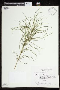 435720[1331211]Smith, Michael 1041996-08-16 United States, Minnesota, Saint Louis, Voyageurs National Park. St. Louis Co.; Plot name: Voya 14 DNR # 5772; Cranberry Bay/ 48 34'02" 93 02'36";Voyageurs National Park;070N;21W;, 48.5672226 -93.043335 |
MIN:Plants | 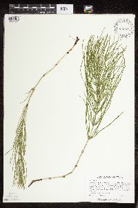 473049[1331091]Lee, Michael MDL12241996-06-03 United States, Minnesota, Wabasha, Dorer Memorial Hardwood State Forest. Wabasha Co.; Valley of West Indian Creek 5 miles NNE of Plainview; along base of 230ft, north-facing slope. At mouth of large tributary valley entering from the east; T109N R11W SW1/4 NW1/4 NE1/4 Sec. 21. 109N 11W 21, 44.331645 -92.326458 |
MIN:Plants | 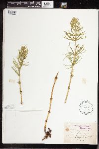 54542[1333692]Burglehaus, F. s.n.1894-06-18 United States, Wyoming, Park, Yellowstone Park ... Alt. 6200 ft. Near Mammoth Hot Springs.;Yellowstone National Park |
MIN:Plants | 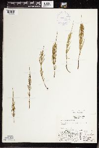 401727[1333690]Spetzman, L. 8691948-07-26 United States, Alaska, Arctic North Slope ... Sadlerochit R.;Arctic National Wildlife Refuge;;;, 69.4166641 -145.1666718, 762m |
MIN:Plants |  408314[1333702]Spetzman, L. 17021949-07-07 United States, Alaska, Arctic North Slope ... Anaktuvuk Pass;Gates of the Arctic National Park;;;, 68.2833333 -151.4166667, 914m |
MIN:Plants |  928639[1331115]Gudmundson, Barbara 28a1964-06-25 United States, Minnesota, Brown, Mulligan Township; near Wood Lake. [T108N;R33W], 44.154668 -94.813483 |
MIN:Plants |  928636[1326946]Gudmundson, Barbara 311964-06-25 United States, Minnesota, Brown, Burnstown Township; N bank of the Cottonwood River.;;109N;34W;23, 44.23172 -94.895752 |
MIN:Plants |  928635[1326947]Gudmundson, Barbara 301964-06-25 United States, Minnesota, Brown, Burnstown Township; N bank of the Cottonwood River.;;109N;34W;23, 44.23172 -94.895752 |
MIN:Plants |  928627[1326948]Gudmundson, Barbara s.n.1964-09-09 United States, Minnesota, Brown, New Ulin Township; between large parking lot and campground.;Flandrau State Park;110N;30W;32, 44.289771 -94.461825 |
MIN:Plants |  928628[1326949]Gudmundson, Barbara 331964-06-25 United States, Minnesota, Brown, Stately Township; beside county road 3.;;108N;35W;12, 44.172935 -94.990266 |
MIN:Plants |  929033[1326952]Anderson, Chel 22292011-08-30 United States, Minnesota, Lake, Knife Lake, small bay. UTM: 5329429 / 636002. NENW of section;Boundary Waters Canoe Area Wilderness / Superior National Forest;065N;07W;24, 48.1035883 -91.1731133 |
MIN:Plants |  922658[1326953]Smith, Welby 233061993-08-03 United States, Minnesota, Renville, Skalbakken County Park. Skalbakken County Park, in the Minnesota Valley about 4 miles southwest of Sacred Heart. Along the north bank of the Minnesota River...T 115N R 38W SW1/4 of SE1/4 of sec 27. 115N 38W 27, 44.7338889 -95.4097222 |
MIN:Plants | 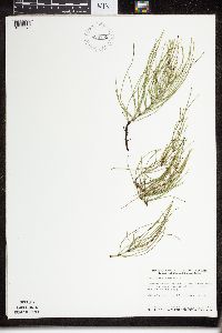 929753[1326971]Smith, Welby 161141989-08-14 United States, Minnesota, Cook, North end of Frost Lake. NE1/4 of SE1/4 of section;Boundary Waters Canoe Area Wilderness / Superior National Forest;064N;04W;27, 47.992084 -90.819354 |
MIN:Plants | 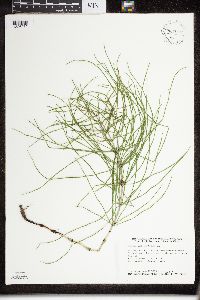 931012[1326970]Smith, Welby R. 158771989-07-20 United States, Minnesota, Mille Lacs, About 5 miles northwest of Onamia. SW1/4 of SW1/4 of section.;Mille Lacs Kathio State Park;042N;27W;10, 46.1311111 -93.7436111 |
MIN:Plants | 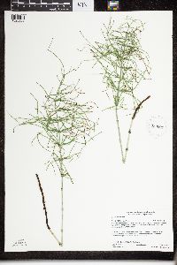 930601[1326968]Gerdes, Lynden B. 61672010-08-05 United States, Minnesota, Lake, Approximately 0.27 miles west of the far northwestern portion of Ester Lake and 0.09 miles northwest of the northern tip of an unnamed lake. NE1/4 of SE1/4 of section;Superior National Forest;066N;06W;27, 48.1719444 -91.0783333 |
MIN:Plants | 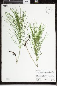 930696[1326969]Gerdes, Lynden B. 60152010-06-16 United States, Minnesota, Cook, Approximately 0.71 miles southeast of McFarland Lake and 0.14 miles northeast of Cty. Rd.16. NESWSESW of section;Superior National Forest;064N;03E;10, 48.0363889 -90.0486111 |
MIN:Plants |  934055[1326967]Smith, Welby R. 33526 United States, Minnesota, Redwood, About 3 miles southeast of Seaforth. NE of NE of section;Daubs Lake Wildlife Area;111N;37W;04, 44.4563889 -95.2927778 |
MIN:Plants |  931709[1326966]Smith, Welby R. 203001992-06-02 United States, Minnesota, Redwood, About 3 miles northeast of Belview NE of NW of section;;114N;37W;27, 44.6563889 -95.2977778 |
MIN:Plants |  935494[1326964]Smith, Welby R. 330752011-07-22 United States, Minnesota, Blue Earth, About 7 miles E-SE of Mapleton. SE of NW of section;Pick WMA;105N;25W;16, 43.8991 -93.8389167 |
MIN:Plants |  935448[1326965]Smith, Welby R. 331582011-08-02 United States, Minnesota, Koochiching, About 14 miles W-SW of Silverdale, along Holmstrom Forest Road. NW of NW of section;Koochiching State Forest;063N;24W;16, 47.9508167 -93.4198 |
MIN:Plants |  936035[1326959]Smith, Welby R. 323782011-05-28 United States, Minnesota, Dakota, about 10 miles W-SW of Hastings. NE of SE of section;Vermillion Highlands State Wildlife Management Are;114N;19W;13, 44.67855 -93.0380667 |
MIN:Plants |  936084[1326960]Smith, Welby R. 324602011-06-06 United States, Minnesota, Dakota, about 7 miles N-NW of Northfield. NE of SE of section;Chub Lake State Wildlife Management Area;113N;20W;33, 44.5510333 -93.22245 |
MIN:Plants |  936164[1326961]Smith, Welby R. 326142011-06-15 United States, Minnesota, Koochiching, About 9 miles southwest of Silverdale. SW1/4 of NW1/4 of section;Koochiching State Forest;063N;23W;27, 47.9169444 -93.2736111 |
MIN:Plants |  936316[1326963]Smith, Welby R. 328972011-06-26 United States, Minnesota, Beltrami, about 11 miles southeast of Fourtown. NW of SE of section;Red Lake State Wildlife Management Area;155N;35W;14, 48.24345 -95.1069667 |
MIN:Plants |  936935[1331009]Smith, Welby R. 302162007-07-06 United States, Minnesota, Becker, About 7 miles southwest of Osage. SE of NW of section;Smokey Hills State Forest;139N;37W;16, 46.8570839 -95.3666387 |
MIN:Plants |  936960[1331012]Smith, Welby R. 302422007-07-11 United States, Minnesota, Marshall, At the base of Randeen Ridge. SE of NW of section;Thief Lake Wildlife Management Area;158N;39W;19, 48.4921545 -95.7245484 |
MIN:Plants |  937093[1331365]Smith, Welby R. 322802010-09-05 United States, Minnesota, Lake, Along County Road 7, about 1.5 miles west of the Cook County line. SW of SE of section;;061N;06W;02, 47.7918248 -91.0498828 |
MIN:Plants |  936843[1331361]Smith, Welby R. 300082007-05-31 United States, Minnesota, Goodhue, About 3 miles west of Welsh along the Cannon Valley Trail. NW of NW of section;;112N;16W;05, 44.5404952 -92.7689703 |
MIN:Plants |  936851[1331360]Smith, Welby R. 300162007-06-01 United States, Minnesota, Meeker, On the north side of Washington lake; about 3 miles west of Dassel. NW of SW of section;Darwin County Park;119N;29W;30, 45.0848742 -94.3748918 |
MIN:Plants |  936869[1331364]Smith, Welby R. 300342007-06-04 United States, Minnesota, Stearns, About 4 miles south of Grey Eagle. NE of NE of section;Birch Lakes State Forest;127N;33W;36, 45.7730556 -94.7705556 |
MIN:Plants |  936878[1331363]Smith, Welby R. 300442007-06-06 United States, Minnesota, Stearns, SE of SW of section;Padua Wildlife Management Area;125N;34W;18, 45.6313707 -95.0090444 |
MIN:Plants |  936883[1331362]Smith, Welby R. 300502007-06-06 United States, Minnesota, Stearns, About 5 miles west of Belgrade. SW of SE of section;Tamarack Wildlife Management Area;123N;35W;08, 45.4727094 -95.0969961 |
MIN:Plants |  936603[1326974]Smith, Welby R. 300662007-06-13 United States, Minnesota, Itasca, About 2 miles north-northwest of Swan River (town). SW of SW of section;;053N;22W;06, 47.0998111 -93.1849152 |
MIN:Plants |  936892[1326973]Smith, Welby R. 300722007-06-14 United States, Minnesota, Todd, On east side of Hwy 71, 1.9 miles north from jct with Hwy 22 in Eagle Bend. NE of NE of section;;131N;35W;02, 46.1915224 -95.0456458 |
MIN:Plants |  936903[1331089]Smith, Welby R. 300832007-06-14 United States, Minnesota, Todd, On east side of Hwy 71, 1.9 miles north from jct with Hwy 22 in Eagle Bend. NE of NE of section;;131N;35W;02, 46.1915224 -95.0456458 |
MIN:Plants |  936911[1331371]Smith, Welby R. 300922007-06-14 United States, Minnesota, Otter Tail, About 5 miles E-NE of Parkers Prairie. NW of NE of section;Eastern Wildlife Management Area;131N;36W;09, 46.1773838 -95.2153801 |
MIN:Plants |  936922[1331011]Smith, Welby R. 302032007-07-05 United States, Minnesota, Otter Tail, In a state wildlife management area about 2 miles north of New York Mills. SE of NE of section;;136N;37W;31, 46.5525913 -95.3891806 |
MIN:Plants |  936952[1331305]Smith, Welby R. 302322007-07-11 United States, Minnesota, Marshall, NW of NE of section;Agassiz National Wildlife Refuge;156N;41W;36, 48.2927902 -95.8587815 |
MIN:Plants |  936981[1331010]Smith, Welby R. 302632007-07-12 United States, Minnesota, Beltrami, Just northwest of the junction of highways 1 and 89. SW of SE of section;;154N;36W;27, 48.1239934 -95.2543216 |
MIN:Plants |  936989[1331369]Smith, Welby R. 302712007-07-12 United States, Minnesota, Beltrami, About 9 miles east of the Pennington County line on Hwy 1. SW of SE of section;;154N;37W;27, 48.1242392 -95.3844429 |
MIN:Plants |  936999[1331368]Smith, Welby R. 302832007-07-12 United States, Minnesota, Beltrami, About 6 miles north of Four Town. NW of SW of section;;157N;36W;31, 48.3698873 -95.3367353 |
MIN:Plants |  937008[1331367]Smith, Welby R. 302912007-07-12 United States, Minnesota, Beltrami, About 17 miles north of Four Town. NE of NW of section;;158N;36W;05, 48.537376 -95.3122395 |
MIN:Plants |  937044[1331370]Smith, Welby R. 322292010-09-03 United States, Minnesota, Saint Louis, Along the Whiteface River about 6 miles east of Cotton. NE of NE of section;;054N;16W;10, 47.1808761 -92.348627 |
MIN:Plants |  937084[1331366]Smith, Welby R. 322702010-09-04 United States, Minnesota, Cook, On the east side of Marsh Lake, about 10 miles northeast of Grand Marais. NW of NW of section;;062N;02E;10, 47.8716885 -90.1861526 |
MIN:Plants |  363106[1327000]Smith, Welby R. 306082007-08-21 United States, Minnesota, Beltrami, About 9 miles northwest of Blackduck. NW of NW of section;;150N;32W;14, 47.8145004 -94.7166641 |
MIN:Plants |  297568[1331356]Smith, Welby R. 306302007-08-21 United States, Minnesota, Koochiching, About 7 miles east of Kelliher. SE of NW of section;;152N;29W;36, 47.943313 -94.3043859 |
MIN:Plants |  491528[1331357]Smith, Welby R. 306372007-08-21 United States, Minnesota, Itasca, About 10 miles south of Northhome. SW of NW of section;;149N;28W;08, 47.7400884 -94.2634635 |
MIN:Plants |  386125[1331353]Smith, Welby R. 306482007-08-22 United States, Minnesota, Koochiching, At the northwest end of Dark Lake. NW of NW of section;Pine Island State Forest;152N;27W;27, 47.9611111 -94.0983333 |
MIN:Plants |  61291[1331349]Smith, Welby R. 306572007-08-22 United States, Minnesota, Koochiching, About 5.5 miles west of Big Falls. SW of NE of section;Pine Island State Forest;155N;26W;36, 48.2042626 -93.9142111 |
MIN:Plants |  186254[1331358]Smith, Welby R. 306812007-08-23 United States, Minnesota, Koochiching, At the north end of Moose Lake. SE of SE of section;;068N;24W;09, 48.3915724 -93.4245327 |
MIN:Plants |  228161[1331359]Smith, Welby R. 306962007-08-23 United States, Minnesota, Koochiching, About 13 miles southeast of Little fork. NW of NE of section;Koochiching State Forest;067N;24W;36, 48.2543666 -93.3640647 |
MIN:Plants |  939439[1331003]Smith, Welby R. 301072007-06-20 United States, Minnesota, Todd, About 7 miles NE of Osakis. NW of NW of section;Santer Wildlife Management Area;128N;35W;01, 45.9298516 -95.0320685 |
MIN:Plants |  939459[1331354]Smith, Welby R. 301322007-06-26 United States, Minnesota, Sibley, In the Valley of High Island Creek ca 2.5 miles SW of its confluence with the Minnesota River. NE of SW of section;Vale Wildlife Management Area;113N;26W;27, 44.5625 -93.9427778 |
MIN:Plants |  939466[1331352]Smith, Welby R. 301392007-06-26 United States, Minnesota, Nicollet, About 7 miles north of Mankato. NW of NE of section;Seven Mile Creek County Park;109N;27W;11, 44.2661198 -94.0357805 |
Google Map
Google Maps is a web mapping service provided by Google that features a map that users can pan (by dragging the mouse) and zoom (by using the mouse wheel). Collection points are displayed as colored markers that when clicked on, displays the full information for that collection. When multiple species are queried (separated by semi-colons), different colored markers denote each individual species.