University of Minnesota
http://www.umn.edu/
612-625-5000
http://www.umn.edu/
612-625-5000
Minnesota Biodiversity Atlas
Bell Museum
Dataset: MIN-Plants
Taxa: Fragaria
Search Criteria: excluding cultivated/captive occurrences
Bell Museum plants | |
 MIN:Plants | 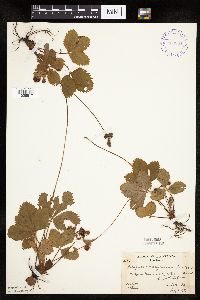 Fragaria virginiana Duchesne 400961[1026917]Butters, F.; Moore, John 108441939-07-02 United States, Minnesota, Cook, above Pigeon River at outlet of South Fowl Lake, T64N, R3E. Cook Co.;Pigeon River Cliffs, The Nature Conservancy / Superior National Forest;064N;03E;12, 48.075089 -90.022876 |
MIN:Plants | 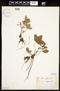 Fragaria virginiana Duchesne 400998[1027080]Dahl, A. 171945-06-16 United States, Minnesota, Cook, near Poplar Lake, T64N, R1W6;Superior National Forest;064N;01W;6, 48.046734 -90.508674 |
MIN:Plants | 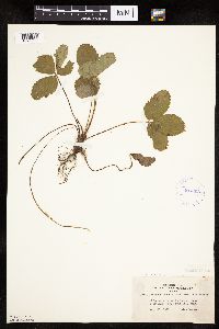 Fragaria virginiana Duchesne 407093[1026962]Lakela, Olga 95151949-08-28 United States, Minnesota, Saint Louis, Lake Kabetogama;Voyageurs National Park;;;, 48.470908 -93.008801 |
MIN:Plants | 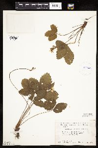 Fragaria virginiana Duchesne 412140[1027082]Moore, John; Moore, Marjorie 120831939-08-23 United States, Minnesota, Koochiching, Koochiching Co.; bank of old channel of the Rainy River, 1/4 mi E of Indus bank of old channel of the Rainy River, 1/4 mi E of Indus. 159N 25W , 48.625232 -93.832195 |
MIN:Plants | 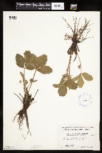 Fragaria virginiana Duchesne 412627[1027133]Moore, John; Moore, Marjorie 106601939-05-07 United States, Minnesota, Dakota, 1 mi. S of Mendota.;;028N;23W;, 44.872706 -93.164387 |
MIN:Plants | 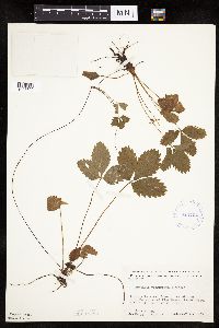 Fragaria virginiana Duchesne 413704[1027690]Moore, John; Moore, Marjorie 110291939-07-21 United States, Minnesota, Lake of the Woods, 1 mi. up from the mouth of Pine Creek, Angle Inlet, 3/4 of a mi. W of the creek.;Northwest Angle;N;;, 49.346587 -95.047469 |
MIN:Plants | 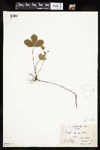 Fragaria virginiana Duchesne 419341[1027026]Briggs, John De Q.; Briggs, Marjorie 61945-08-03 United States, Minnesota, Cook, Cook Co.; Sawbill Trail, T64N R4W;Boundary Waters Canoe Area Wilderness / Superior National Forest;062N;04W;, 47.88583 -90.87778 |
MIN:Plants | 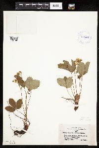 Fragaria virginiana Duchesne 419512[1027165]Lakela, Olga 102151950-06-10 United States, Minnesota, Saint Louis, Lake Kabetogama at Herseth's Vacation Camp;;N;;, 48.437695 -93.027374 |
MIN:Plants | 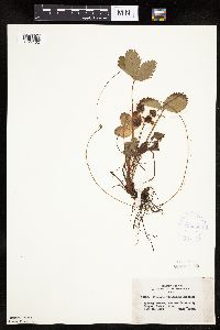 Fragaria virginiana Duchesne 420580[1027162]Lakela, Olga 107001950-07-16 United States, Minnesota, Saint Louis, new University Campus, Duluth;;050N;14W;14, 46.7833 -92.1 |
MIN:Plants | 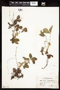 Fragaria virginiana Duchesne 420708[1027163]Lakela, Olga 101261950-06-02 United States, Minnesota, Saint Louis, Forest Hill Cemetery, Duluth;;N;;, 46.7833 -92.1 |
MIN:Plants | 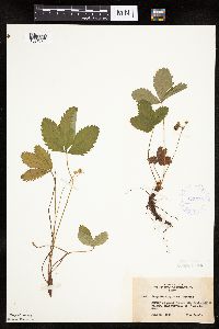 Fragaria virginiana Duchesne 422539[1027161]Lakela, Olga 75251948-06-20 United States, Minnesota, Saint Louis, St. Louis River Valley, near Toivola;;N;;, 47.160456 -92.805917 |
MIN:Plants | 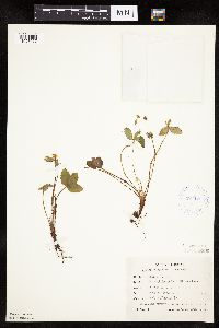 Fragaria virginiana Duchesne 424123[1027027]Emanuel, J. 41946-06-12 United States, Minnesota, Itasca, County: Itasca. Locality: Nashwauk Township (5 mi N Keewatin);;058N;22W;00, 47.413912 -93.13289 |
MIN:Plants | 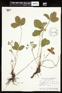 Fragaria virginiana Duchesne 430056[1026939]Smith, Welby 152081989-05-31 United States, Minnesota, Freeborn, Carex Wildlife Management Area. Freeborn County ... 'Carex' State Wildlife Management Area, about 7 miles east-southeast of Hollandale ... NW1/4 NW1/4 section 23, T 103N R 19W. 103N 19W 23, 43.7155571 -93.0866699 |
MIN:Plants |  Fragaria virginiana Duchesne 434842[1026897]Myhre, K. 20521992-06-01 United States, Minnesota, Cass, Cass Co.; Located on the top of a hill along the steep southeast shore of Big Deep Lake; T 140N R 29W NW1/4 of NW1/4 of Cass Co.; Located on the top of a hill along the steep southeast shore of Big Deep Lake; T 140N R 29W NW1/4 of NW1/4 of Sec 32. 140N 29W 32, 46.90508 -94.381717 |
MIN:Plants | 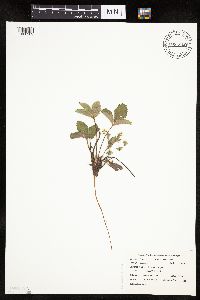 Fragaria virginiana Duchesne 435040[1026902]Swanson, Gary 15451999-05-06 United States, Minnesota, Sherburne, Sherburne National Wildlife Refuge; NWSW 3-34-27;Sherburne National Wildlife Refuge;034N;27W;3, 45.465423 -93.684687 |
MIN:Plants | 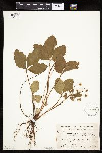 Fragaria virginiana Duchesne 436993[1027116]Moore, John; Hall, Robert 162701944-06-07 United States, Minnesota, Martin, R.R. right-of-way, 1 mi. W of Fairmont.;;N;;, 43.652176 -94.481102 |
MIN:Plants | 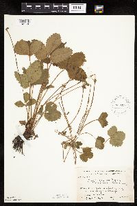 Fragaria virginiana Duchesne 437015[1027130]Moore, John; Hall, Robert 162941944-06-08 United States, Minnesota, Nobles, Along Rock Island right-of-way, 1 mi. N of Worthington.;;N;;, 43.634449 -95.596398 |
MIN:Plants | 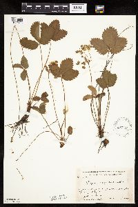 Fragaria virginiana Duchesne 437176[1027193]Moore, John; Hall, Robert 164441944-06-11 United States, Minnesota, Lincoln, Along r.r. right-of-way at Tyler.;;N;;, 44.2783 -96.134755 |
MIN:Plants | 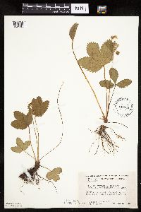 Fragaria virginiana Duchesne 441965[1027110]Moore, John; Huff, N. 184631946-06-05 United States, Minnesota, Nicollet, 1 mi. E of Nicollet, Nicollet Co.;;109N;28W;, 44.276076 -94.167235 |
MIN:Plants | 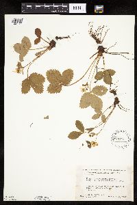 Fragaria virginiana Duchesne 445137[1027123]Moore, John; Huff, N. 194101947-05-28 United States, Minnesota, Pine, 3 mi. SE of Hinckley;;N;;, 45.980618 -92.900147 |
MIN:Plants | 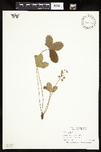 Fragaria virginiana Duchesne 445371[1027145]Nation, R. 94-0261994-05-26 United States, Minnesota, Mower, Lake Louise State Park. Mower Co.; Tract 1A. T101N R14W NW1/4 of SW1/4 of sec. 21;Lake Louise State Park;101N;14W;21, 43.536579 -92.519043 |
MIN:Plants | 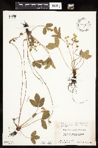 Fragaria virginiana Duchesne 445998[1027191]Moore, John; et al. 173531945-06-20 United States, Minnesota, Red Lake, Red Lake County...2 mi. S of Red Lake Falls;;151N;44W;, 47.879295 -96.274214 |
MIN:Plants | 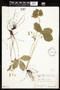 Fragaria virginiana Duchesne 446101[1027088]Moore, John 196161947-06-18 United States, Minnesota, Kandiyohi, near Mt. Tom, Sibley State Park;Sibley State Park;N;;, 45.319687 -95.02307 |
MIN:Plants | 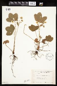 Fragaria virginiana Duchesne 448720[1027188]Moore, John 170351945-06-06 United States, Minnesota, Todd, 1/2 mi. E of Staples;;N;;, 46.355518 -94.781752 |
MIN:Plants | 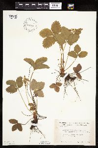 Fragaria virginiana Duchesne 448984[1027129]Moore, John 170921945-06-07 United States, Minnesota, Wadena, 5 1/2 mi. N of Wadena;;N;;, 46.522088 -95.136139 |
MIN:Plants | 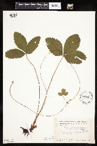 Fragaria virginiana Duchesne 449084[1027108]Moore, John; Hall, Robert 168171944-08-03 United States, Minnesota, Crow Wing, 1 mi. S of Emily.;;N;;, 46.716595 -93.95803 |
MIN:Plants | 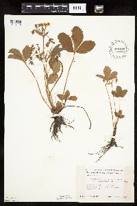 Fragaria virginiana Duchesne 449135[1027115]Moore, John 169801945-05-30 United States, Minnesota, Martin, Along r.r, 3 1/2 mi. N of Fairmont.;;N;;, 43.702874 -94.461083 |
MIN:Plants | 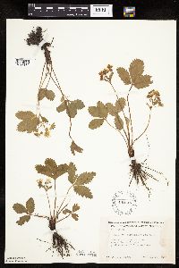 Fragaria virginiana Duchesne 449146[1027189]Moore, John 169881945-05-31 United States, Minnesota, Cottonwood, 1/2 mi. W of Bingham Lake.;;N;;, 43.906623 -95.056431 |
MIN:Plants | 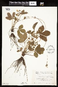 Fragaria virginiana Duchesne 449175[1027121]Moore, John 170131945-06-01 United States, Minnesota, Blue Earth, Along r.r. right-of-way, 2 mi. E of Lake Crystal.;;N;;, 44.110967 -94.176448 |
MIN:Plants | 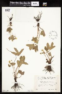 Fragaria virginiana Duchesne 449228[1027122]Moore, John 169451945-05-30 United States, Minnesota, Watonwan, Along the r.r, 1.7 mi. SW of St. James.;;106N;32W;, 43.949287 -94.64089 |
MIN:Plants |  Fragaria virginiana Duchesne 457072[1026980]Smith, Welby 131211987-06-24 United States, Minnesota, Pine, Pine Co.; St. Croix State Park; about 70 ft above floodplain of the St. Croix River. NE1/4 SW1/4 sec.31, T 41N R 17W;Saint Croix State Park;041N;17W;31, 45.990634 -92.541657 |
MIN:Plants | 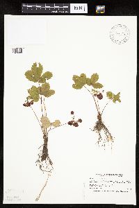 Fragaria virginiana Duchesne 457083[1026899]Smith, Welby 189121991-06-21 United States, Minnesota, Aitkin, Hill River State Forest. Aitkin Co.; along the north side of Washburn Lake, about 6 miles east of Hill City; Aitkin Co.; along the north side of Washburn Lake, about 6 miles east of Hill City; T 52N R 25W NW1/4 of SW1/4 of Sec 24. 052N 25W 24, 46.980278 -93.4599991 |
MIN:Plants | 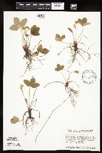 Fragaria virginiana Duchesne 461571[1027014]Smith, Welby 113791986-05-03 United States, Minnesota, Sherburne, Sherburne Co. Sherburne National Wildlife Refuge, about 2.5 mi SE of Santiago. NE1/4 SW1/4 sec 23, T35N R28W;Sherburne National Wildlife Refuge;035;28W;23, 45.5074997 -93.7938919 |
MIN:Plants | 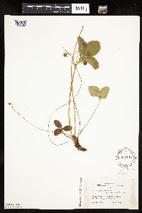 Fragaria virginiana Duchesne 463145[1026940]Lakela, Olga 141371952-06-16 United States, Minnesota, Saint Louis, At Namakan Narrows;Voyageurs National Park;069N;17W;, 48.430739 -92.490154 |
MIN:Plants | Fragaria virginiana Duchesne 464056[]Johnson, A. 31561928-07-10 United States, Minnesota, Itasca, Lake shore at Farley's; Ingersand, Sand Lake;;N;;, 47.492402 -93.505636 |
MIN:Plants | 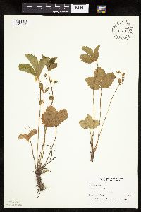 Fragaria virginiana Duchesne 477292[1027144]Nation, R. 94-0041994-05-26 United States, Minnesota, Mower, Lake Louise State Park. Mower Co.; Tract #13S. T101N R14W SE1/4 of SE1/4 of sec. 21;Lake Louise State Park;101N;14W;21, 43.536579 -92.519043 |
MIN:Plants | 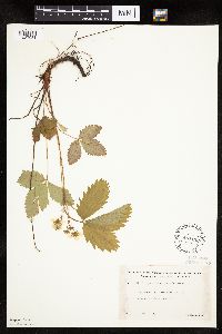 Fragaria virginiana Duchesne 481133[1027081]Lakela, Olga 159721953-06-07 United States, Minnesota, Saint Louis, Vermilion Lake at Treasure Island Resort;;N;;, 47.891581 -92.366824 |
MIN:Plants | 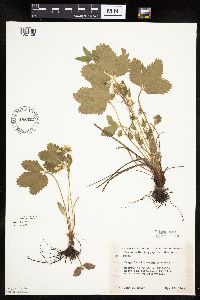 Fragaria virginiana Duchesne 488422[1027105]Moore, John 199451949-05-12 United States, Minnesota, Big Stone, Above Big Stone Lake 14 mi NW of Ortonville;;;;, 45.447855 -96.648592 |
MIN:Plants | 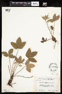 Fragaria virginiana Duchesne 497392[1027094]Moore, John 201061949-06-03 United States, Minnesota, Todd, 2 mi SE of Staples;;N;;, 46.33504 -94.762575 |
MIN:Plants | 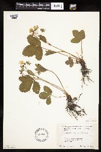 Fragaria virginiana Duchesne 500794[1026921]Moore, John 204701950-05-24 United States, Minnesota, Martin, along roadside 2 1/2 mi SE of East Chain;;N;;, 43.533233 -94.329913 |
MIN:Plants | 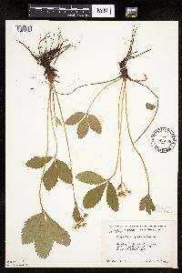 Fragaria virginiana Duchesne 503069[1027172]Moore, John 205321950-06-06 United States, Minnesota, Stevens, N end of Lower Pomme De Terre Lake;;N;;, 46.02342 -95.883255 |
MIN:Plants |  Fragaria virginiana Duchesne 505795[1027013]Smith, Welby 114331986-05-16 United States, Minnesota, Sherburne, Sherburne Co. Sherburne National Wildlife Refuge, about 2.5 mi SE of Orrock. SW1/4 SE1/4 sec 10, T34N R27W;Sherburne National Wildlife Refuge;034N;27W;10, 45.4444427 -93.6819458 |
MIN:Plants | 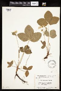 Fragaria virginiana Duchesne 507424[1026950]Moore, John; et al. 210071951-06-08 United States, Minnesota, Itasca, Itasca County...back shore of Coon Lake, Scenic State Park;Scenic State Park;;;, 47.723007 -93.563738 |
MIN:Plants | 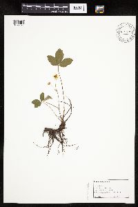 Fragaria virginiana Duchesne 516164[1027020]Butts, A. 71996-06-03 United States, Minnesota, Lyon, Camden State Park; Lyon Co. - Lyons Township. NW 1/4 of SE 1/4, sect.7, T110N R42W;Camden State Park;110N;42W;7, 44.346395 -95.944003 |
MIN:Plants | 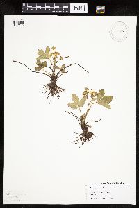 Fragaria virginiana Duchesne 518875[1026893]Swanson, Gary s.n.1997-05-10 United States, Minnesota, Sherburne, Sherburne National Wildlife Refuge; SE SW S31 T35 R27;Sherburne National Wildlife Refuge;T035N R27W S31, 45.479859 -93.747463 |
MIN:Plants | 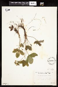 Fragaria virginiana Duchesne 525933[1027093]Lakela, Olga 186791955-06-04 United States, Minnesota, Saint Louis, Kabetogama Lake Road, near jnc with Hwy 53;Kabetogama State Forest;N;;, 48.470908 -93.008801 |
MIN:Plants | 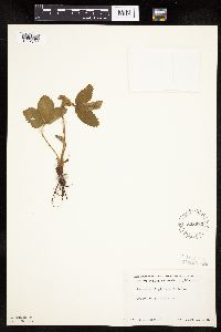 Fragaria virginiana Duchesne 528930[1027102]Borchard, Alma s.n.1945-06-13 United States, Minnesota, Blue Earth, Mapleton;;N;;, 43.928851 -93.956064 |
MIN:Plants |  Fragaria virginiana Duchesne 533152[1027103]Lakela, Olga 197661956-06-12 United States, Minnesota, Saint Louis, N of Sturgeon Lake, Hwy #5, Morcom T.;George Washington State Forest;N;;, 47.763775 -93.018127 |
MIN:Plants | 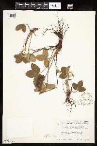 Fragaria virginiana Duchesne 542330[1027109]Moore, John 215261952-05-20 United States, Minnesota, Koochiching, Koochiching Co.; 1 mi. N of Big Falls 1 mi. N of Big Falls. 155N 25W , 48.191111 -93.802222 |
MIN:Plants | 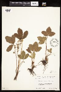 Fragaria virginiana Duchesne 542444[1027167]Moore, John 216491952-06-02 United States, Minnesota, Brown, 1 mi S of New Ulm;;N;;, 44.29798 -94.460529 |
MIN:Plants | 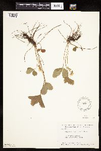 Fragaria virginiana Duchesne 542561[1026914]Moore, John; et al. 214791952-05-18 United States, Minnesota, Anoka, Cedar Creek Forest, 49D, Lawrence's Woods;Cedar Creek National History Area;034N;23W;, 45.40217 -93.199397 |
MIN:Plants | 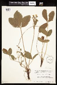 Fragaria virginiana Duchesne 542742[1027168]Moore, John 217471952-06-05 United States, Minnesota, Watonwan, Watonwan Co.; along SW shore of Wood Lake;;107N;33W;, 44.0833 -94.75 |
MIN:Plants | 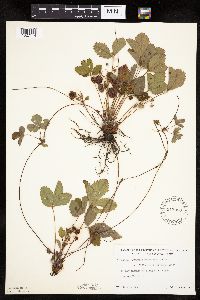 Fragaria virginiana Duchesne 543008[1027114]Lakela, Olga 214591957-07-02 United States, Minnesota, Saint Louis, Along r.r. at Payne, Hwy. 7.;;N;;, 47.096049 -92.599358 |
MIN:Plants | Fragaria virginiana Duchesne 548924[]Pease, T. s.n.1888-06-05 United States, Minnesota, Anoka, [no further data];;N;;, 45.198637 -93.238648 |
MIN:Plants |  Fragaria virginiana Duchesne 553823[1026948]Moore, John; et al. 227611956-06-08 United States, Minnesota, Clay, Clay County...On N side of r.r. near Buffalo State Park Entrance.;;139N;46W;10, 46.86404 -96.46709 |
MIN:Plants | 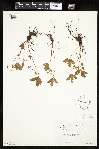 Fragaria virginiana Duchesne 554348[1027087]Moore, John 228821956-06-12 United States, Minnesota, Norman, 6 mi E of Ada;;N;;, 47.299618 -96.387276 |
MIN:Plants | 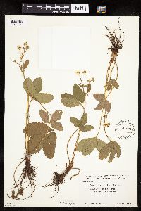 Fragaria virginiana Duchesne 558272[1027190]Moore, John 236921958-05-25 United States, Minnesota, Blue Earth, 1 mi. W of Cambria;;N;;, 44.238574 -94.334626 |
MIN:Plants | 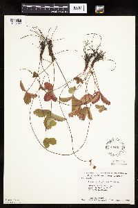 Fragaria virginiana Duchesne 566422[1027092]Moore, John; Heig, V. 240541958-09-09 United States, Minnesota, Kittson, along rr right-of-way 1 mi S of Humboldt;;N;;, 48.906625 -97.093393 |
MIN:Plants | 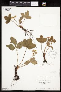 Fragaria virginiana Duchesne 574579[1026926]Moore, John 244801959-05-27 United States, Minnesota, Kittson, 2 mi W of Karlstad;;N;;, 48.577468 -96.564345 |
MIN:Plants | 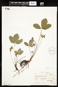 Fragaria virginiana Duchesne 583968[1026998]Gunderson, R. 1071961-05-20 United States, Minnesota, Washington, Washington County ... St. Croix R, 3 mi N of Stillwater;Saint Croix National Riverway;030N;20W;, 45.099799 -92.806041 |
MIN:Plants | 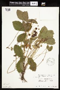 Fragaria virginiana Duchesne 585362[1026988]Moore, John 260971962-06-29 United States, Minnesota, Kittson, 4 1/2 mi NE of Halma;;N;;, 48.707117 -96.530603 |
MIN:Plants | 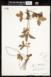 Fragaria virginiana Duchesne 585715[1027078]Moore, John 262401963-05-16 United States, Minnesota, Anoka, NE1/4 S26, Bethel Twp, Cedar Creek Natural History Area;Cedar Creek National History Area;034N;23W;26, 45.319849 -93.296468 |
MIN:Plants | 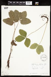 Fragaria virginiana Duchesne 590040[1026984]Meierotto, R. s.n.1962-08-02 United States, Minnesota, Mahnomen, Mahnomen Co. S.20 T143N R40W.;White Earth Indian Reservation;143N;40W;20, 47.186591 -95.773924 |
MIN:Plants | 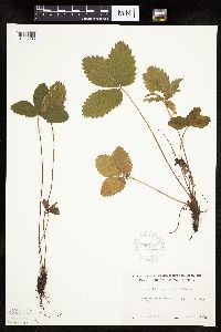 Fragaria virginiana Duchesne 590117[1026985]Meierotto, R. s.n.1962-07-26 United States, Minnesota, Becker, Becker Co. Sec.5 T142N R36W;Itasca State Park;142N;36W;5, 47.144933 -95.265368 |
MIN:Plants | 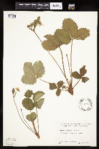 Fragaria virginiana Duchesne 592317[1026987]Westkaemper, Remberta s.n.1964-06-00 United States, Minnesota, Stearns, Stearns Co. St. Joseph. St. Benedict's [College] woods.;;124N;29W;, 45.564772 -94.317966 |
MIN:Plants | 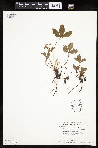 Fragaria virginiana Duchesne 603913[1026982]Moore, John; Moore, Marjorie 271171967-06-09 United States, Minnesota, Pipestone, NE corner of Pipestone National Monument;Pipestone National Monument;106N;46W;, 44.013519 -96.324755 |
MIN:Plants | 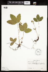 Fragaria virginiana Duchesne 607277[1026986]Grafstrom, M. 191968-06-11 United States, Minnesota, Pine, Pine Co. T40N R18W NW1/4 Sec.12.;Saint Croix State Park;040N;18W;12, 45.972384 -92.545919 |
MIN:Plants | 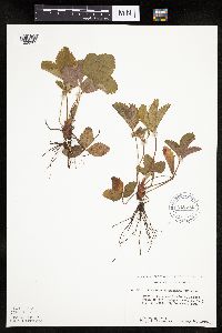 Fragaria virginiana Duchesne 616571[1026983]Moore, John; Moore, Marjorie 331969-05-10 United States, Minnesota, Crow Wing, Crow Wing Natural History Area; N of the headquarters; SW1/4 SE1/4 Sec.18 Garrison Twp.;Crow Wing Natural Area;044N;28W;18, 46.293847 -93.926565 |
MIN:Plants | 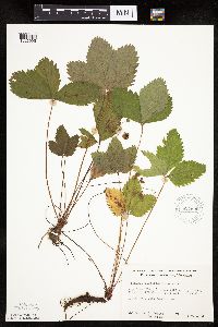 Fragaria virginiana Duchesne 627690[1026995]Ownbey, Gerald 45521972-07-09 United States, Minnesota, Cass, Cass Co. Boy River Bog, 3 mi E of Boy River, N1/2 NE1/4 Sec.23 T143N R27W.;Chippewa National Forest;143N;27W;23, 47.101979 -94.06127 |
MIN:Plants | 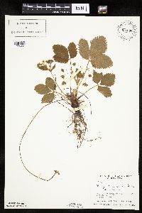 Fragaria virginiana Duchesne 631538[1026937]Richards, Donald; et al. 16051971-06-04 United States, Minnesota, Itasca, Itasca County...N shore of Deer Lake, 18 mi. NW of Grand Rapids.;;;;, 47.37852 -93.66181 |
MIN:Plants | 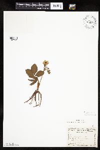 Fragaria virginiana Duchesne 655176[1027023]Gage Jr., Addison 321876-05-16 United States, Minnesota, Hennepin, Minneapolis;;N;;, 44.979965 -93.263836 |
MIN:Plants | 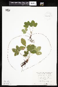 Fragaria virginiana Duchesne 663651[1026992]Noble, Mark; et al. 6141975-08-01 United States, Minnesota, Lake, 22 mi SE of Ely at the jnc of the Little Isabella River and Tomahawk Road.;Superior National Forest;061N;09W;29, 47.739123 -91.506097 |
MIN:Plants | 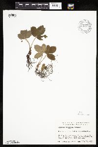 Fragaria virginiana Duchesne 669756[1026959]Wheeler, Gerald s.n.1975-07-11 United States, Minnesota, Saint Louis, 6 mi N of Babbitt on Hwy 21;;N;;, 47.795374 -91.944603 |
MIN:Plants | 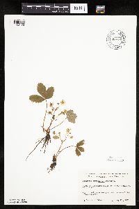 Fragaria virginiana Duchesne 669790[1027173]Wheeler, Gerald s.n.1974-05-25 United States, Minnesota, Meeker, Sioux Lake; 8 mi SSE of Litchfield, ca 1/8 mi W of the lake;;N;;, 45.021073 -94.463044 |
MIN:Plants | 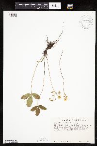 Fragaria virginiana Duchesne 670771[1027041]Heitlinger, M. 5461972-05-30 United States, Minnesota, McLeod, Schaefer Prairie: SE1/4 Sec. 34, T115N, R29W. (TNC);Schaefer Prairie, The Nature Conservancy;115N;29W;34, 44.724106 -94.305158 |
MIN:Plants | 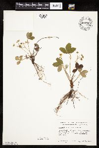 Fragaria virginiana Duchesne 680752[1027187]Clemants, Steven 6591977-05-21 United States, Minnesota, Chisago, Goose Creek. Along section line between Sec. 14 and 23. T36N, R21W. W side of line.;;N;;, 45.600508 -92.934524 |
MIN:Plants | 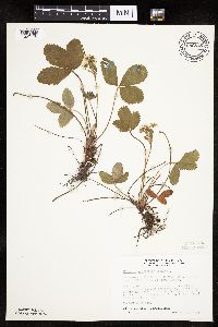 Fragaria virginiana Duchesne 686815[1027178]Wheeler, Gerald; Glaser, Paul 12411977-05-14 United States, Minnesota, Itasca, coll. site no. 1; SE1/4 SE1/4 S19, T56N, R26W; ca 10 mi NW of Grand Rapids;;056N;26W;19, 47.312604 -93.684832 |
MIN:Plants | 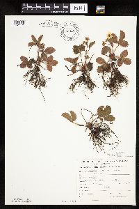 Fragaria virginiana Duchesne 689425[1027179]Genenah, A. s.n.1967-05-17 United States, Minnesota, Hennepin, Fort Snelling;Fort Snelling Military Reservation;N;;, 44.870583 -93.209602 |
MIN:Plants | 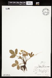 Fragaria virginiana Duchesne 691106[1026929]Sperling, C. 1241976-05-25 United States, Minnesota, Douglas, 4 1/2 mi S, 3 mi W of Holmes City, wildlife area;;N;;, 45.768398 -95.603426 |
MIN:Plants | 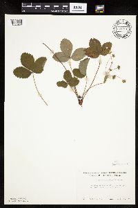 Fragaria virginiana Duchesne 691280[1026958]Lightfoot, J. s.n.1977-09-24 United States, Minnesota, Pine, Pine Co. SW1/4 of NW1/4 S20, T43, R21;;T043N R21W S20, 46.194764 -93.022397 |
MIN:Plants | 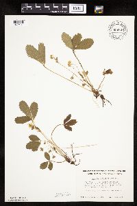 Fragaria virginiana Duchesne 696737[1027040]Smith, Welby 6221978-05-23 United States, Minnesota, Wright, Wright Co.; T122N, R25W, N1/2 Sec. 32. Between the Mississippi River and Burlington Northern tracks. Ca. 3 mi. NW of M Wright Co.; T122N, R25W, N1/2 Sec. 32. Between the Mississippi River and Burlington Northern tracks. Ca. 3 mi. NW of Monticello on Co. Rd. 75.. 122N 25W 32, 45.331908 -93.860001 |
MIN:Plants | 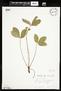 Fragaria virginiana Duchesne 697972[1026999]Ownbey, Gerald 51521976-05-23 United States, Minnesota, Washington, Afton State Park, T28N, R20W, SW1/4 S34, bluff above stream;Afton State Park;028N;20W;34, 44.865358 -92.796712 |
MIN:Plants | 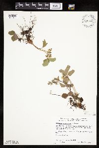 Fragaria virginiana Duchesne 698020[1027180]Wheeler, Gerald; Glaser, Paul 28201978-05-23 United States, Minnesota, Beltrami, NW1/4 NE1/4 S1, T156N, R31W; ca 14.5 mi N of the Waskish Airport on Rte 72, just W of the road;;156N;31W;1, 48.34475 -94.586613 |
MIN:Plants | Fragaria virginiana Duchesne 698656[]Wheeler, Gerald; Glaser, Paul 33871978-10-22 United States, Minnesota, Koochiching, Red Lake Peatland Scientific Natural Area. Koochiching Co.; SW1/4 SE1/4 S3, T156N, R29W; ca 16 mi NNE of Waskish SW1/4 SE1/4 S3, T156N, R29W; ca 16 mi NNE of Waskish. 156N 29W 3, 48.360681 -94.349301 |
MIN:Plants | 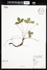 Fragaria virginiana Duchesne 698828[1027150]Sather, Nancy; et al. 531976-06-07 United States, Minnesota, Saint Louis, St. Louis Co. Sec. 14, T60N, R12W.;Superior National Forest;T060N R12W S14, 47.680271 -91.828259 |
MIN:Plants | 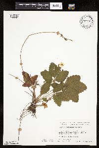 Fragaria virginiana Duchesne 700992[1026942]Dorio, J. 7631977-08-10 United States, Minnesota, Morrison, Lake Alexander, ca. 7 mi. N of Randall on Co. Rd. 6. T131N, R30W, Sec. 6.;;131N;30W;6, 46.187068 -94.506234 |
MIN:Plants | 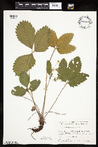 Fragaria virginiana Duchesne 701026[1026934]Dorio, J. 1961977-06-10 United States, Minnesota, Morrison, Ripley Esker, ca. 3 mi. NE of Camp Ripley Jct. T42N, R31W, Sec. 19.;Ripley Esker Scientific Natural Area;042N;31W;19, 46.116667 -94.308333 |
MIN:Plants | 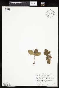 Fragaria virginiana Duchesne 709999[1026993]Wheeler, Gerald 50291979-10-06 United States, Minnesota, Le Sueur, Le Sueur Co. Approx. 1 mi SW of Kasota; bluff overlooking the Minnesota River. High Lime Prairie. T109N R26W Sec.6;East Minnesota River Wildlife Management Area;109N;26W;6, 44.274575 -93.998475 |
MIN:Plants | 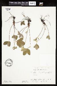 Fragaria virginiana Duchesne 715122[1026971]Severson, M. 111979-06-12 United States, Minnesota, Polk, (TNC) 4.5 mi. S of Fischer, W1/2 of NW1/4 of Sec.;Malmberg Prairie Scientific Natural Area;T149N R48W S16, 47.72417 -96.813966 |
MIN:Plants | 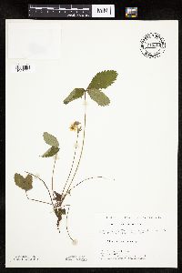 Fragaria virginiana Duchesne 715351[1027024]Farrell, P. 321979-06-19 United States, Minnesota, Beltrami, Lake Bemidji Bog SNA: 1 mi. NW of Lake Bemidji, N1/2 of NW1/4 of Sec. 24, T147N, R33W.;;147N;33W;24, 47.536135 -94.815118 |
MIN:Plants | 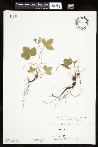 Fragaria virginiana Duchesne 715602[1026973]Keller, C. 181978-06-08 United States, Minnesota, Beltrami, Pennington Orchid Bog SNA: 1 mi. N of Pennington, NW1/4 Sec. 3, T146N, R30W.;Leech Lake Indian Reservation / Pennington Bog Scientific Natural Area;146N;30W;3, 47.494806 -94.474276 |
MIN:Plants | 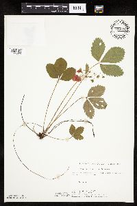 Fragaria virginiana Duchesne 715672[1026976]Keller, C. 1001979-07-19 United States, Minnesota, Beltrami, Pennington Orchid Bog SNA: 1 mi. N of Pennington, NW1/4 Sec. 3, T146N, R30W.;Leech Lake Indian Reservation / Pennington Bog Scientific Natural Area;146N;30W;3, 47.494806 -94.474276 |
MIN:Plants | 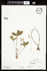 Fragaria virginiana Duchesne 716982[1026972]Heitlinger, M. 6711975-06-02 United States, Minnesota, Anoka, Helen Allison Savanna Scientific Natural Area. Anoka Co. Helen Allison Savanna. N1/2 of NE1/4 of Sec. 2, T33N, R23W. Near the SW boundary of the NE 10 acres of the Anoka Co. Helen Allison Savanna. N1/2 of NE1/4 of Sec. 2, T33N, R23W. Near the SW boundary of the NE 10 acres of the tract, which are burned in the spring.. 033N 23W 2, 45.380475 -93.168729 |
MIN:Plants | 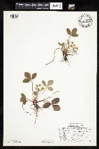 Fragaria virginiana Duchesne 717375[1026970]Mathisen, Ron s.n.1979-06-01 United States, Minnesota, Hubbard, Spearhead Lake Reserve;Spearhead Lake Preserve (Audubon);145N;34W;, 47.368324 -94.990759 |
MIN:Plants | 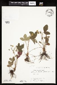 Fragaria virginiana Duchesne 717745[1026974]Borowske, J.; et al. 281979-06-11 United States, Minnesota, Norman, Frenchman's Bluff: (TNC) 2.5 mi. N of Flom, frac. of Sec. 18, T143N, R43W.;Frenchmans Bluff Scientific Natural Area;143N;43W;18, 47.201968 -96.183894 |
MIN:Plants | 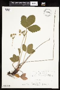 Fragaria virginiana Duchesne 720133[1027199]Ottoson, S. 231979-06-11 United States, Minnesota, 2 miles southwest of Fertile.;Agassiz Dunes Scientific Natural Area;;;, 47.51564 -96.31032 |
MIN:Plants | 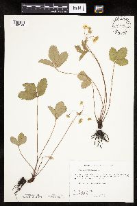 Fragaria virginiana Duchesne 721522[1027154]Farrell, P. 371979-06-22 United States, Minnesota, Polk, 7 mi. SE of Crookston. S1/2 of section;Pankratz Memorial Prairie, The Nature Conservancy;149N;45W;08, 47.73852 -96.44879 |
MIN:Plants | 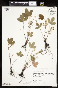 Fragaria virginiana Duchesne 721531[1027148]Keller, C. 121979-06-11 United States, Minnesota, Polk, Pankratz Prairie North: (TNC) 7 mi. SE of Crookston, S1/2 Sec. 8, T149N, R45W.;Pankratz Memorial Prairie, The Nature Conservancy;149N;45W;8, 47.738518 -96.44879 |
MIN:Plants | 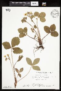 Fragaria virginiana Duchesne 722456[1027198]Lustig, K. 2841979-05-24 United States, Minnesota, Anoka, Anoka County... Boot Lake SNA: 18 mi. SE of Cambridge, Sec. 17, 18, 19, 20, T33N, R22W.;Boot Lake Scientific Natural Area;033N;22W;00, 45.340967 -93.123493 |
MIN:Plants | 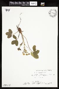 Fragaria virginiana Duchesne 722555[1027197]Lustig, K. 2581979-05-17 United States, Minnesota, Anoka, 18 mi. SE of Cambridge;Boot Lake Scientific Natural Area;033N;22W;, 45.338145 -93.123956 |
Google Map
Google Maps is a web mapping service provided by Google that features a map that users can pan (by dragging the mouse) and zoom (by using the mouse wheel). Collection points are displayed as colored markers that when clicked on, displays the full information for that collection. When multiple species are queried (separated by semi-colons), different colored markers denote each individual species.