University of Minnesota
http://www.umn.edu/
612-625-5000
http://www.umn.edu/
612-625-5000
Minnesota Biodiversity Atlas
Bell Museum
Dataset: MIN-Plants
Taxa: Fragaria
Search Criteria: excluding cultivated/captive occurrences
Bell Museum plants | |
 MIN:Plants | 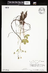 Fragaria virginiana Duchesne 723686[1027107]Smith, Welby 23351980-06-03 United States, Minnesota, Martin, T104N, R30W, SE1/4 Sec. 7. Ca. 1/8 mi. N of Co. Rd. 50, 2 1/4 mi. W of it's jct. with Hwy. 15 in Truman.;;104N;30W;7, 43.825466 -94.48011 |
MIN:Plants |  Fragaria virginiana Duchesne 723687[1027125]Smith, Welby 20701980-05-10 United States, Minnesota, Winona, Winona Co. T108N, R10W, NE1/4 SW1/4 Sec. 14. 0.15 mi. NE of the jct. of co. rds. 30 and 74, near the town of Beaver.;Whitewater Wildlife Management Area;108N;10W;14, 44.15652 -91.990286 |
MIN:Plants | 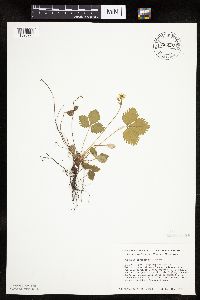 Fragaria virginiana Duchesne 724597[1026923]Smith, Welby 21241980-05-12 United States, Minnesota, Wright, M Schmidt Crawford Woods Scientific Natural Area. Wright Co.; T120N, R25W, NW1/4 SE1/4 of Sec.25, near SW shore of Schmidt Lake, ca 0.3 mi N of Co Hwy 34; 4.5 mi E of its Wright Co.; T120N, R25W, NW1/4 SE1/4 of Sec.25, near SW shore of Schmidt Lake, ca 0.3 mi N of Co Hwy 34; 4.5 mi E of its jnc with State Hwy 55 near Buffalo. 120N 25W 25, 45.171 -93.773669 |
MIN:Plants | 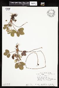 Fragaria virginiana Duchesne 724724[1027035]Smith, Welby 20851980-05-10 United States, Minnesota, Wabasha, T109N, R09W, NW1/4 Sec. 8. Ca. 1 mi. E of Hwy. 84.;;109N;09W;8, 44.258009 -91.918672 |
MIN:Plants | 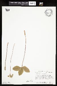 Fragaria virginiana Duchesne 724746[1026947]Smith, Welby 23761980-06-05 United States, Minnesota, Grant, T128N, R41W, NW1/4 SW1/4 SE1/4 Sec. 12. 1/8 mi. N of Co. Rd. 2, and 1/2 mi. W of the Grant-Douglas Co. line.;;128N;41W;12, 45.912281 -95.769155 |
MIN:Plants | 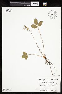 Fragaria virginiana Duchesne 724810[1026960]Smith, Welby 24041980-06-10 United States, Minnesota, Kandiyohi, T122N, R33W, NW1/4 NE1/4 NE1/4 S16, ca 3/8 mi W of a twp. rd, and 1/8 mi S of a farm road that seperates sections 16 and T122N, R33W, NW1/4 NE1/4 NE1/4 S16, ca 3/8 mi W of a twp. rd, and 1/8 mi S of a farm road that seperates sections 16 and 9.. 122N 33W 16, 45.376923 -94.835117 |
MIN:Plants | 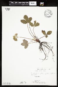 Fragaria virginiana Duchesne 727140[1027042]Ottoson, S. 91979-06-06 United States, Minnesota, Norman, Twin Valley Prairie: (TNC) 5 mi. W of Syre, NW1/4 and E1/2 of SW1/4 of Sec. 23, T143N, R45W.;Twin Valley Prairie Scientific Natural Area;143N;45W;23, 47.187516 -96.353808 |
MIN:Plants |  Fragaria virginiana Duchesne 727598[1027039]Smith, Welby 24841980-06-12 United States, Minnesota, Saint Louis, T51N, R18W, SW1/4 NW1/4 Sec. 4. On the N side of Co. Rd. 8, ca. 13 mi. due E of Floodwood.;;051N;18W;4, 46.934197 -92.628406 |
MIN:Plants | 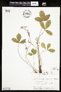 Fragaria virginiana Duchesne 730556[1027152]Petron, T. 451980-06-06 United States, Minnesota, Wilkin, Western Prairie North: 8 mi N of Rothsay, NW1/4 SE1/4 S17, T136N, R45W;Western Prairie North, The Nature Conservancy;136N;45W;17, 46.59078 -96.280619 |
MIN:Plants | 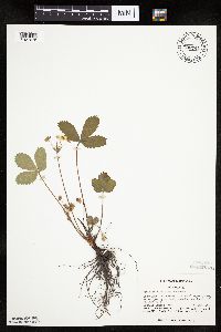 Fragaria virginiana Duchesne 730741[1027076]Benson, Douglas 881981-06-11 United States, Minnesota, Wilkin, Anna Gronseth Prairie: T134N, R45W center of NE1/4 SE1/4 S9, NE corner of grove;Anna Gronseth Prairie, The Nature Conservancy;134N;45W;9, 46.434856 -96.35422 |
MIN:Plants |  Fragaria virginiana Duchesne 732604[1027075]Severson, M. 1801980-05-21 United States, Minnesota, Becker, Zimmerman Prairie: 10 mi W of Ogema, E1/2 SW1/4 S16, T142N, R43W;Zimmerman Prairie [TNC];142N;43W;16, 47.111989 -96.14657 |
MIN:Plants |  Fragaria virginiana Duchesne 734469[1027085]Severson, M. 1461980-05-21 United States, Minnesota, Becker, Green Water Lake Natural Area: 5 mi W of Ponsford, NW1/4 SE1/4 S33, T141N, R38W;Greenwater Lake Scientific Natural Area / White Earth Indian Reservation;141N;38W;33, 46.982254 -95.495125 |
MIN:Plants |  Fragaria virginiana Duchesne 734710[1027086]Severson, M. 1081980-05-20 United States, Minnesota, Clay, Bluestem Prairie: 13 mi E of Moorhead, NW1/4 S15, T139N, R46W;Bluestem Prairie Scientific Natural Area;139N;46W;15, 46.854978 -96.473401 |
MIN:Plants |  Fragaria virginiana Duchesne 737289[1026905]Kachman, R. 2191980-05-25 United States, Minnesota, Mower, NW section of Adams Community Park;;N;;, 43.56441 -92.71685 |
MIN:Plants | 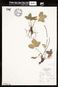 Fragaria virginiana Duchesne 738113[1027160]Pollan, S. 51978-05-18 United States, Minnesota, Saint Louis, R15W, T48N, S2, St. Louis R. Estuary, Waterfront Trail Area;;T048N R15W S2, 46.671312 -92.208001 |
MIN:Plants |  Fragaria virginiana Duchesne 738400[1026919]Galatowitsch, S. 1401982-05-30 United States, Minnesota, Wabasha, Wabasha County...Weaver Dunes: T109N, R9W SE1/4 and E1/2 NE1/4 of Sec. 7; NW1/4 and W1/2 NE1/4 Sec. 8;Kellogg-Weaver Dunes Scientific Natural Area / Kellogg-Weaver Dunes, The Nature Conservancy;109N;09W;00, 44.25811 -91.93891 |
MIN:Plants | 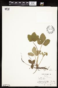 Fragaria virginiana Duchesne 738434[1026903]Galatowitsch, S. 721982-05-13 United States, Minnesota, Rice, Rice Co. Trout Lily Preserve: T110N, R20W S1/2 NW1/4 SW1/4 of S20; part of NE1/4 SE1/4 S19;Cannon River Trout Lily Scientific Natural Area;110N;20W;, 44.31962 -93.262308 |
MIN:Plants | 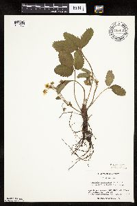 Fragaria virginiana Duchesne 738440[1026906]Galatowitsch, S. 891982-05-13 United States, Minnesota, Goodhue, Grace Nature Preserve: T109N, R18W parts of NW1/4 SW1/4 and SW1/4 SW1/4 of S8;Grace Nature Preserve, The Nature Conservancy;109N;18W;8, 44.262012 -93.010543 |
MIN:Plants | 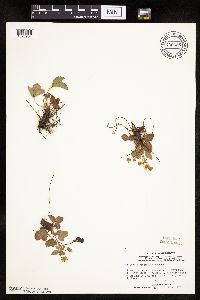 Fragaria virginiana Duchesne 739336[1026904]Stackler, S. 11721976-05-06 United States, Minnesota, Carlton, Skunk Creek Basin, SE grade along RR tracks, NE along Soo Line from Duesler crossing, ca 8 mi E, 1/4 mi N Barnum (T46N, Skunk Creek Basin, SE grade along RR tracks, NE along Soo Line from Duesler crossing, ca 8 mi E, 1/4 mi N Barnum (T46N, R17W, S33). 046N 17W 33, 46.511863 -92.498 |
MIN:Plants | 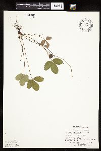 Fragaria virginiana Duchesne 739636[1026994]Converse, C. 15341982-07-09 United States, Minnesota, Swift, Chippewa and Swift Cos. Chippewa Prairie: SW1/4 SE1/4 Sec.35 T120N R43W.;Chippewa Prairie, The Nature Conservancy;120N;43W;35, 45.159258 -96.010767 |
MIN:Plants | 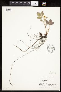 Fragaria virginiana Duchesne 740021[1026932]Converse, C. 7611982-05-15 United States, Minnesota, Pope, Ordway Prairie: T123N, R36W SW1/4 NW1/4 S30;Ordway Prairie, The Nature Conservancy;123N;36W;30, 45.434262 -95.245019 |
MIN:Plants | 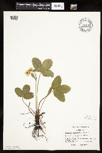 Fragaria virginiana Duchesne 740081[1026949]Converse, C. 7891982-05-19 United States, Minnesota, Douglas, Staffanson Prairie: T127N, R40W, NW1/4 NE1/4 and NE1/4 NW1/4 S18;Staffanson Prairie, The Nature Conservancy;127N;40W;18, 45.810665 -95.748006 |
MIN:Plants | 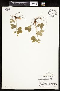 Fragaria virginiana Duchesne 740119[1026915]Converse, C. 7301982-05-05 United States, Minnesota, Kandiyohi, Moe Woods: T123N, R36W NE1/4 NW1/4 S3;Moe Woods, The Nature Conservancy;123N;36W;3, 45.405555 -95.183293 |
MIN:Plants | 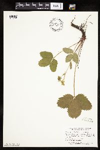 Fragaria virginiana Duchesne 746622[1027011]Smith, Welby 38061981-05-18 United States, Minnesota, Mower, Wild Indigo Scientific Natural Area. Wild Indigo Scientific and Natural Area, ca 2 1/4 mi E of the jnc of State Hwy 56 and Co Hwy 2 in Brownsdale, SE1/4 SW1/ Wild Indigo Scientific and Natural Area, ca 2 1/4 mi E of the jnc of State Hwy 56 and Co Hwy 2 in Brownsdale, SE1/4 SW1/4 S12, T103N, R17W. 103N 17W 12, 43.7396 -92.819237 |
MIN:Plants |  Fragaria virginiana Duchesne 746631[1027010]Smith, Welby 39351981-05-26 United States, Minnesota, Steele, ca 1 1/2 mi ESE of Havana, between U.S. Hwy 14 and the Chicago and Northwestern RR tracks, NE1/4 SW1/4 S21, T107N, R19W;;107N;19W;21, 44.05785 -93.118899 |
MIN:Plants | 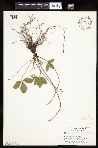 Fragaria virginiana Duchesne 746632[1027009]Smith, Welby 39161981-05-25 United States, Minnesota, Dakota, Dakota Co. About 1 mi S of Black Dog Lake in the Minnesota Valley. NW1/4 NE1/4 S34, T27N, R24W;Black Dog Preserve Scientific Natural Area;027N;24W;34, 44.788737 -93.275528 |
MIN:Plants | 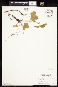 Fragaria virginiana Duchesne 746660[1027008]Smith, Welby 37761981-05-10 United States, Minnesota, Wright, Wright Co.; about 1 3/4 mi SE of Silver Creek, and S of Co Hwy 39, NW1/4 NW1/4 S15, T121N, R26W;;121N;26W;15, 45.294353 -93.95204 |
MIN:Plants | 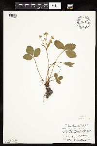 Fragaria virginiana Duchesne 746663[1027007]Smith, Welby 39521981-05-17 United States, Minnesota, Jackson, Kilen Woods State Park. Kilen Woods State Park. Ca 1/4 mi W of the Des Moines River on a N facing slope above a small unnamed tributary stream. Kilen Woods State Park. Ca 1/4 mi W of the Des Moines River on a N facing slope above a small unnamed tributary stream. SE1/4 NW1/4 S17, T103N, R35W. 103N 35W 17, 43.753479 -94.984108 |
MIN:Plants | 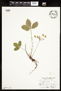 Fragaria virginiana Duchesne 746673[1027006]Smith, Welby 39811981-05-28 United States, Minnesota, Rice, Ca 3 1/4 mi due S of Dundas, in the Cannon River Valley, NE1/4 NE1/4 Sec.;Cannon River Wilderness Park;111N;20W;34, 44.377714 -93.211094 |
MIN:Plants | 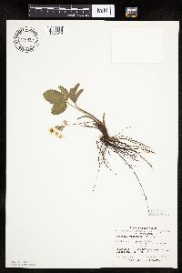 Fragaria virginiana Duchesne 746875[1027019]Lee, Craig 71982-05-20 United States, Minnesota, Kandiyohi, Regal Meadow: T122N, R33W S1/2 NE1/4, NE1/4 SE1/4, and part of NE1/4 NE1/4 S16;Regal Meadow, The Nature Conservancy;122N;33W;16, 45.376923 -94.835117 |
MIN:Plants | 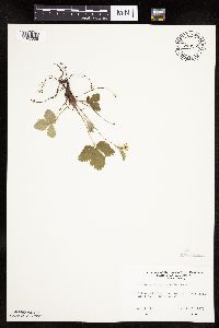 Fragaria virginiana Duchesne 749552[1027005]Ehritt, K. s.n.1977-04-23 United States, Minnesota, Le Sueur, Le Sueur Co. Ottawa Bluffs: NE1/4 S3, T110N, R26W;Ottawa Bluffs, The Nature Conservancy;110N;26W;3, 44.362619 -93.939379 |
MIN:Plants | 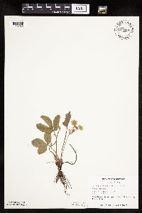 Fragaria virginiana Duchesne 753414[1027032]Duxbury, Alexis 10321983-05-25 United States, Minnesota, Jackson, Blue Gentian Prairie: part of SW1/4 SE1/4 Sec. 13, T103N, R36W.;Blue Gentian Prairie;103N;36W;13, 43.724814 -95.105572 |
MIN:Plants |  Fragaria virginiana Duchesne 753415[1027031]Duxbury, Alexis 10341983-05-26 United States, Minnesota, Murray, Lundblad Prairie: W1/2 NW1/4 Sec. 1; T105N, R41W.;Lundblad Prairie Scientific Natural Area;105N;41W;1, 43.927817 -95.713386 |
MIN:Plants |  Fragaria virginiana Duchesne 753416[1026953]Duxbury, Alexis 10151983-05-25 United States, Minnesota, Nobles, Compass Prairie: part of SE1/4 SW1/4 Sec. 3; T101N, R41W.;Compass Prairie Scientific Natural Area;101N;41W;3, 43.580108 -95.743853 |
MIN:Plants |  Fragaria virginiana Duchesne 753430[1027033]Duxbury, Alexis 24991983-09-07 United States, Minnesota, Redwood, Redwood Co. Wahpeton Prairie: S1/2 NW1/4 Sec. 19, T110N, R38W.;Wahpeton Prairie, The Nature Conservancy;110N;38W;29, 44.304783 -95.440814 |
MIN:Plants |  Fragaria virginiana Duchesne 753432[1027030]Duxbury, Alexis 10841983-05-30 United States, Minnesota, Lyon, Glynn Prairie: S1/2 NE1/4 Sec. 7; T09N, R40W.;Glynn Prairie Scientific Natural Area;109N;40W;7, 44.262693 -95.699254 |
MIN:Plants | 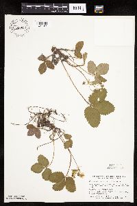 Fragaria virginiana Duchesne 758054[1027157]Smith, Welby 59231982-05-14 United States, Minnesota, Wright, Wright Co.; between Albion Lake and Co. Hwy 6, about 2 mi S of its jnc with State Hwy 55. NE1/4 SW1/4 S10, T120N, R27W;;120N;27W;10, 45.215605 -94.066994 |
MIN:Plants | 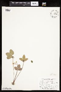 Fragaria virginiana Duchesne 758342[1027004]Smith, Welby 61961982-06-09 United States, Minnesota, Clay, ca 3 mi ESE of the jnc of State Hwy 9 and Co Hwy 34 in Felton. NE1/4 SE1/4 S36, T142N, R46W;;142N;46W;36, 47.070359 -96.446855 |
MIN:Plants | 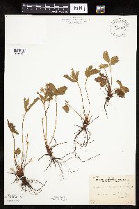 Fragaria virginiana Duchesne 762896[1026968]Gilbert, H. 1531923-06-07 United States, Minnesota, Saint Louis, Duluth;;N;;, 46.7833 -92.1 |
MIN:Plants | 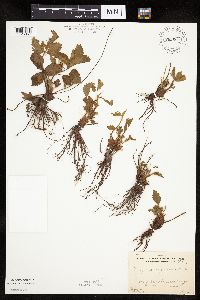 Fragaria virginiana Duchesne 762897[1026967]Gilbert, H. 741923-05-14 United States, Minnesota, Saint Louis, Duluth;;N;;, 46.7833 -92.1 |
MIN:Plants |  Fragaria virginiana Duchesne 762898[1027202]Gilbert, H. 451923-05-28 United States, Minnesota, Saint Louis, Duluth;;;;, 46.7833 -92.1 |
MIN:Plants | 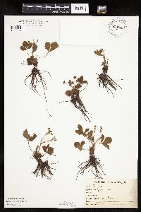 Fragaria virginiana Duchesne 764055[1026966]Foote, Lewis s.n. United States, Minnesota, Nobles, Worthington;;N;;, 43.619964 -95.596398 |
MIN:Plants | 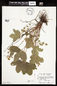 Fragaria virginiana Duchesne 770052[1026901]Smith, Welby 77891983-06-04 United States, Minnesota, Wabasha, Kellogg-Weaver Dunes Scientific Natural Area / Kellogg-Weaver Dunes, The Nature Conservancy. Kellogg-Weaver Dunes State Scientific and Natural Area. Ca. 4 mi. SE of Kellogg, on the E side of Co. Rd. 84. NW1/4 NE Kellogg-Weaver Dunes State Scientific and Natural Area. Ca. 4 mi. SE of Kellogg, on the E side of Co. Rd. 84. NW1/4 NE1/4 Sec. 6, T109N, R09W.. 109N 09W 6, 44.272608 -91.938982 |
MIN:Plants | 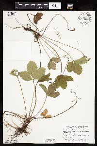 Fragaria virginiana Duchesne 770444[1027037]Smith, Welby 76761983-05-18 United States, Minnesota, Mower, Lake Louise State Park, ca. 1 mi. NNW of Le Roy. SW1/4 SW1/4 Sec. 21, T101N, R14W.;Lake Louise State Park;101N;14W;21, 43.536616 -92.51902 |
MIN:Plants | 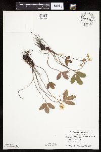 Fragaria virginiana Duchesne 770504[1027036]Smith, Welby 77771983-06-01 United States, Minnesota, Swift, Swift Co. On the right-of-way of the Burlington Northern Railroad ca. 1 mi. SE of Murdock. NW1/4 SE1/4 Sec. 12, T120N, Swift Co. On the right-of-way of the Burlington Northern Railroad ca. 1 mi. SE of Murdock. NW1/4 SE1/4 Sec. 12, T120N, R38W.. 120N 38W 12, 45.217888 -95.379082 |
MIN:Plants | 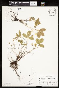 Fragaria virginiana Duchesne 770563[1027038]Smith, Welby 80661983-06-08 United States, Minnesota, Polk, Belgium State Wildlife Management Area, ca. 4 mi. ENE of Euclid. NW1/4 NE1/4 Sec. 16, T152N, R46W.;Belgium Wildlife Management Area;152N;46W;16, 47.985145 -96.558273 |
MIN:Plants | 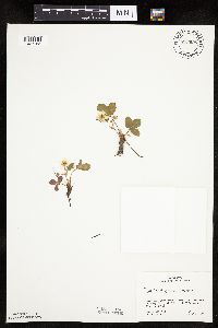 Fragaria virginiana Duchesne 773095[1027155]Boe, J. 371979-06-01 United States, Minnesota, Lake of the Woods, Near Norris Camp. T159N, R35W, Sec. 8.;;159N;35W;8, 48.605309 -95.181076 |
MIN:Plants | 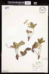 Fragaria virginiana Duchesne 773110[1027021]Boe, J. 271979-05-31 United States, Minnesota, Lake of the Woods, just S of Cecil's Landing on Roosevelt Road, NE1/4 S4, R35W, T160N;;160N;35W;4, 48.8 -95.0833 |
MIN:Plants | 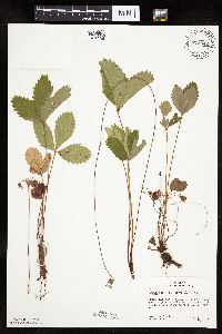 Fragaria virginiana Duchesne 773342[1026938]Boe, J. 6821979-07-10 United States, Minnesota, Lake of the Woods, Lake of the Woods County...Zippel Bay State Park, near Lakeview Campground. T162N, R33W, SE1/4 Sec. 12.;Zippel Bay State Park;162N;33W;12, 48.865892 -94.838967 |
MIN:Plants | 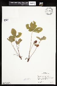 Fragaria virginiana Duchesne 774015[1026965]Boe, J. 7931979-07-15 United States, Minnesota, Lake of the Woods, Angle Inlet. Near rock outcrops S of Angle Inlet. T168N, R34W, N1/2 Sec. 31.;Northwest Angle;168N;34W;31, 49.330606 -95.080858 |
MIN:Plants | 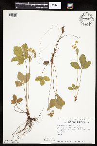 Fragaria virginiana Duchesne 774201[1026952]Monson, Paul 53631983-06-16 United States, Minnesota, Saint Louis, Voyageurs National Park. T70N, R21W, Sec. 34. Kabetogama Peninsula E of Camel Back Island.;Voyageurs National Park;070N;21W;34, 48.470908 -93.008801 |
MIN:Plants |  Fragaria virginiana Duchesne 774308[1026951]Monson, Paul 54561983-06-19 United States, Minnesota, Saint Louis, Voyageurs National Park. R20W, T69N, S36. Kabetogama Narrows Ranger Station. Road from Ash River Trail.;Voyageurs National Park;069N;20W;36, 48.41713 -92.789044 |
MIN:Plants | 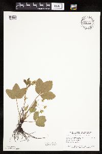 Fragaria virginiana Duchesne 781713[1027029]Smith, Welby 8939A1984-05-30 United States, Minnesota, Cottonwood, Expandere State Wildlife Management Area, ca. 13 mi. WNW of Windom. SE1/4 SW1/4 Sec.1, T105N, R38W.;Expandere Wildlife Management Area;105N;38W;1, 43.922133 -95.35356 |
MIN:Plants | 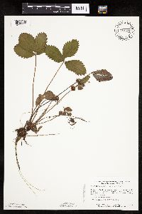 Fragaria virginiana Duchesne 781841[1026896]Smith, Welby 93051984-06-23 United States, Minnesota, Mower, Cartney Wildlife Management Area. Cartney State Wildlife Management Area, ca. 5 mi. NNW of Le Roy. On the banks of the West Branch of Little Iowa River. Cartney State Wildlife Management Area, ca. 5 mi. NNW of Le Roy. On the banks of the West Branch of Little Iowa River. NE1/4 SE1/4 Sec. 5, T101N, R14W.. 101N 14W 5, 43.580049 -92.539234 |
MIN:Plants |  Fragaria virginiana Duchesne 781887[1027034]Smith, Welby 89131984-05-30 United States, Minnesota, Jackson, Sioux Valley Wildlife Management Area, ca. 1 mi. SSE of Sioux Valley. NE1/4 NE1/4 Sec. 29, T101N, R37W.;Sioux Valley Wildlife Management Area;101N;37W;29, 43.52213 -95.304627 |
MIN:Plants |  Fragaria virginiana Duchesne 782346[1027003]Tenney, M. 1451982-06-01 United States, Minnesota, Fillmore, Forestville State Park. Fillmore Co. T102N, R12W, S13, SE1/4 NE1/4 NW1/4;Forestville State Park;102N;12W;13, 43.637724 -92.219269 |
MIN:Plants |  Fragaria virginiana Duchesne 789639[1027001]Smith, Welby 101311985-05-22 United States, Minnesota, Dodge, Iron Horse Prairie Scientific Natural Area. Dodge County...Iron Horse Prairie State Scientific and Natrual Area, about 1 1/2 mi S of Hayfield. NW1/4 SE1/4 sec. 27, T105N, R17W. 105N 17W 27, 43.8675 -92.8486111 |
MIN:Plants |  Fragaria virginiana Duchesne 789649[1027002]Smith, Welby 101981985-05-28 United States, Minnesota, Jackson, Sangl Wildlife Management Area. Sangle State Wildlife Management Area, on N side of Co Hwy 4, ca 1/2 mi E of its jnc with State Hwy 86. NE1/4 SW1/4 S21, Sangle State Wildlife Management Area, on N side of Co Hwy 4, ca 1/2 mi E of its jnc with State Hwy 86. NE1/4 SW1/4 S21, T101N, R36W. 101N 36W 21, 43.537333 -95.164428 |
MIN:Plants | 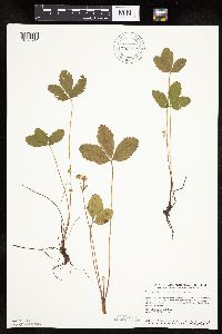 Fragaria virginiana Duchesne 792282[1026941]Smith, Welby 104121985-06-09 United States, Minnesota, Ramsey, Maplewood Nature Center. Ramsey County...In the city of Maplewood, about 1/2 mi. S of Larpenteur Ave. and 1/2 mi. E of McKnight Road. NW1/4 SE1/4 Sec. 24, T29N, R22W. 029N 22W 24, 44.9838889 -92.9936111 |
MIN:Plants | 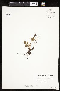 Fragaria virginiana Duchesne 794858[1027186]Sanford, J. s.n.1948-05-05 United States, Minnesota, Anoka, Moore Lake region.;;030N;24W;, 45.077013 -93.252399 |
MIN:Plants | 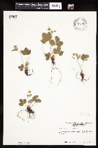 Fragaria virginiana Duchesne 795599[1026979]Bender, J. s.n.1986-05-20 United States, Minnesota, Washington, at Belwin & Charles Bell's property; Afton Twp.;;028N;20W;, 44.927188 -92.791852 |
MIN:Plants | 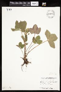 Fragaria virginiana Duchesne 801185[1026931]Smith, Welby 102561985-05-29 United States, Minnesota, Yellow Medicine, Sioux Nation State Wildlife Management Area, ca 8 mi WSW of Canby, NW1/4 SW1/4 S17, T114N, R46W;Sioux Nationalion Wildlife Management Area;114N;46W;17, 44.680542 -96.437023 |
MIN:Plants | 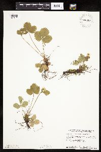 Fragaria virginiana Duchesne 802716[1027017]Smith, Welby 113981986-05-08 United States, Minnesota, Scott, Minnesota Valley National Wildlife Refuge. Scott County...The Louisville Swamp area, in the Minnesota Valley National Wildlife Refuge; about 6 mi. S of Shakopee. NW1/4 SE1/4 Sec. 29, T115N, R23W. 115N 23W 29, 44.7355556 -93.5988889 |
MIN:Plants | 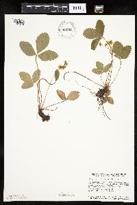 Fragaria virginiana Duchesne 802724[1027016]Smith, Welby 115531986-05-28 United States, Minnesota, Hubbard, Stumpeghes Rapids, ca. 3 mi. N of Becida. NE1/4 SW1/4 Sec. 2, T145N, R35W.;;145N;35W;2, 47.4033318 -95.0919418 |
MIN:Plants | 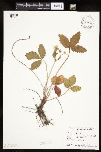 Fragaria virginiana Duchesne 802775[1027015]Smith, Welby 114681986-05-17 United States, Minnesota, Anoka, Lamprey Pass Wildlife Management Area. Anoka County...Lamprey Pass State Wildlife Management Area, about 2 mi. SW of Forest Lake. SW1/4 NE1/4 Sec. 13, T32N, R22W. 032N 22W 13, 45.262769 -93.027391 |
MIN:Plants | 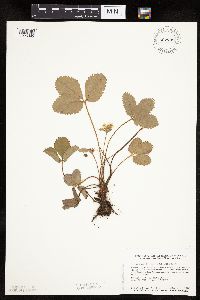 Fragaria virginiana Duchesne 802799[1026895]Smith, Welby 115261986-05-26 United States, Minnesota, Goodhue, Perched Valley Wildlife Management Area. Goodhue County...Perched Valley State Wildlife Management Area, ca. 4 mi. W of Frontenac. NW1/4 SW1/4 Sec. 8, T112N, R13W. 112N 13W 8, 44.5172222 -92.4063889 |
MIN:Plants |  Fragaria virginiana Duchesne 804761[1027147]Ordway, E. 41977-05-23 United States, Minnesota, Pope, 4 mi. NE of Starbuck;Strandness Prairie, The Nature Conservancy;N;;, 45.665007 -95.50008 |
MIN:Plants |  Fragaria virginiana Duchesne 806885[1027185]Siemers, Ross 191977-06-01 United States, Minnesota, Stearns, Stearns Co. Roscoe Prairie Scientific and Natural Area, T123N R32W S35;Roscoe Prairie Scientific Natural Area;123N;32W;35, 45.433611 -94.640278 |
MIN:Plants |  Fragaria virginiana Duchesne 806930[1027158]Siemers, Ross 51977-06-06 United States, Minnesota, Stearns, Stearns Co. Rockville Tamarack Bog. T123N R29W S17;Rockville Tamarack Bog;123N;29W;17, 45.469043 -94.355202 |
MIN:Plants |  Fragaria virginiana Duchesne 814885[1027127]Wheeler, Gerald 113641988-07-25 United States, Minnesota, Lac Qui Parle, Lac Qui Parle State Park. Ca. 15 mi. E of Madison; Lac Qui Parle State Park, N of Rte. 33. Along the Lac Qui Parle River. N1/2 NE1/4 Sec. 23, T1 Ca. 15 mi. E of Madison; Lac Qui Parle State Park, N of Rte. 33. Along the Lac Qui Parle River. N1/2 NE1/4 Sec. 23, T118N, R42W (Lac Qui Parle Twp.). 118N 42W 23, 45.014849 -95.889165 |
MIN:Plants | 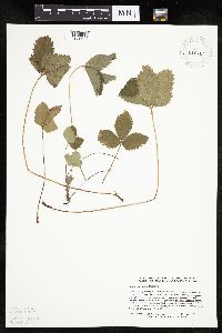 Fragaria virginiana Duchesne 816764[1026997]Delaney, B. 892351989-08-18 United States, Minnesota, Isanti, 0.25 mi NE of Tennyson Lake; NW1/4 SE1/4 sec.17 T35N R25W.;;035N;25W;17, 45.520582 -93.47878 |
MIN:Plants | 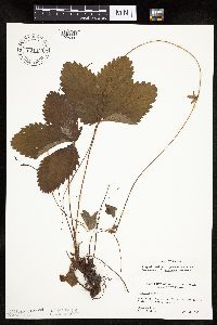 Fragaria virginiana Duchesne 831445[1026991]Cloutier, H. s.n.1943-07-20 United States, Minnesota, Itasca, Itasca Co, Coleraine, Trout Lake vicinity;;N;;, 47.28883 -93.427708 |
MIN:Plants | 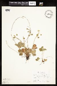 Fragaria virginiana Duchesne 831901[1027159]Bagley, S. 51969-06-02 United States, Minnesota, Cook, St. Louis Co.; elev.1431 ft. R-4W T-66N Sec.28 [this locale actually in Cook Co.];Boundary Waters Canoe Area Wilderness / Superior National Forest;T066N R04W S28, 48.171108 -90.84609 |
MIN:Plants | 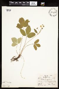 Fragaria virginiana Duchesne 831902[1027126]Yender, R. 251981-06-30 United States, Minnesota, Saint Louis, St. Louis Co.; on Low Lake. Eelv. 1400'. R-12W T-64N Sec.36;Superior National Forest;064N;12W;36, 47.972358 -91.828264 |
MIN:Plants | 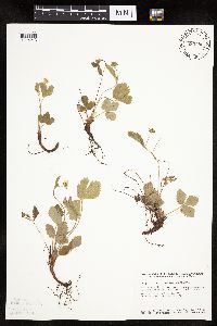 Fragaria virginiana Duchesne 833786[1026913]Smith, Welby 140201988-05-14 United States, Minnesota, Benton, Benton Co. Sartell State Wildlife Management Area, about 2 mi NE of Rice; SW1/4 SW1/4 sec.15, T38N R31W;Sartell Wildlife Management Area;038N;31W;15, 45.786582 -94.186232 |
MIN:Plants | 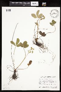 Fragaria virginiana Duchesne 833846[1026978]Smith, Welby 141771988-06-01 United States, Minnesota, Lac Qui Parle, Big Stone National Wildlife Refuge. Lac Qui Parle Co. Big Stone National Wildlife Refuge, about 7 mi NW of Bellingham in the Minnesota River Valley. NE1/4 S Lac Qui Parle Co. Big Stone National Wildlife Refuge, about 7 mi NW of Bellingham in the Minnesota River Valley. NE1/4 SW1/4 sec 1, T120N R46W.. 120N 46W 1, 45.257671 -96.368808 |
MIN:Plants | 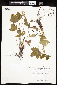 Fragaria virginiana Duchesne 834334[1027156]Monson, Paul 59231984-06-05 United States, Minnesota, Cook, Grand Portage National Monument. Cook Co. R-6E, T-64N, S-32, ca. 1.5 mi NW of Visitor Center;Grand Portage National Monument / North Shore;064N;06E;32, 47.983468 -89.705538 |
MIN:Plants | 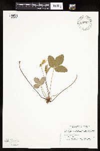 Fragaria virginiana Duchesne 834442[1026898]Myhre, K. 19441992-05-26 United States, Minnesota, Cass, Cass Co. Located on the W side of Jack Lake; T141N R30W NE1/4 of SE1/4 of sec.3;Chippewa National Forest / Leech Lake Indian Reservation;141N;30W;3, 47.057303 -94.451595 |
MIN:Plants |  Fragaria virginiana Duchesne 840416[1026996]Smith, Welby 126641987-05-09 United States, Minnesota, Scott, Murphy-Hanrahan County Park Reserve. Scott County...Murphy-Hanrahan Regional Park, on the S side of Hanrahan Lake, about 2 mi W on [sic] Burnsville. SW1/4 NW1/4 sec. 34, T115N R21W. 115N 21W 34, 44.7277778 -93.3363889 |
MIN:Plants | 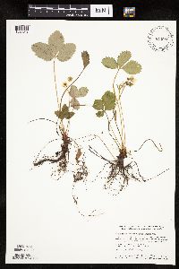 Fragaria virginiana Duchesne 840686[1027018]Smith, Welby 126321987-05-02 United States, Minnesota, Mille Lacs, Mille Lacs Co. Mille Lacs State Wildlife Management Area, about 11 mi N of Bock; SE1/4 NE1/4 sec.24, T40N R26W;Mille Lacs Wildlife Management Area;040N;26W;24, 45.9472237 -93.5199966 |
MIN:Plants | 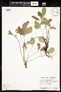 Fragaria virginiana Duchesne 841048[1027012]Smith, Welby 127371987-05-23 United States, Minnesota, Dakota, Dakota Co. In the Minnesota Valley, about 1 mi E of Savage; NE1/4 SW1/4 sec.32, T27N R24W;;027N;24W;32, 44.7816658 -93.3174973 |
MIN:Plants | 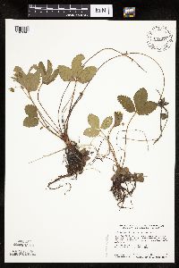 Fragaria virginiana Duchesne 841078[1026894]Smith, Welby 127691987-05-25 United States, Minnesota, Steele, Steele Co. Aurora State Wildlife Management Area, about 8 mi NW of Blooming Prairie; SE1/4 NW1/4 sec.20, T106N R19W;Aurora Wildlife Management Area;106N;19W;20, 43.9736099 -93.1397247 |
MIN:Plants | 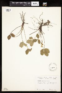 Fragaria virginiana Duchesne 539974[1026930]Tester, John s.n.1957-05-22 United States, Minnesota, Mahnomen, 3-4 miles w. and 1 mile s. of Waubun. ;Waubun Prairie Wildlife Management Area / White Earth Indian Reservation;143N;42W;33, 47.166009 -96.024401 |
MIN:Plants | 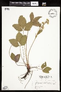 459907[1026737]Kaul, R.; et al. 51731986-05-09 United States, Minnesota, Steele, Steele County...near Straight River, Kaplan's Woods, Owatonna.;;107N;20W;, 44.084579 -93.230139 |
MIN:Plants | 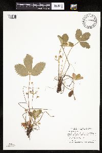 Fragaria virginiana Duchesne 913692[1026918]Smith, Welby 242991994-07-02 United States, Minnesota, Polk, Polk County... On Nancy Sather's farm, about 1.25 miles west of Polk-Clearwater County line... T147N R39W NE1/4 of SE1/4 of Sec 11. 147N 39W 11, 47.5633333 -95.5802778 |
MIN:Plants | 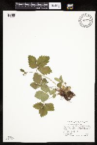 913714[1026781]Smith, Welby 243041994-07-02 United States, Minnesota, Polk, Polk County... Along the south side of the Sand Hill River, about 1.5 miles west of Fertile... T147N R44W NE1/4 of SW1/4 of Sec 19. 147N 44W 19, 47.5325 -96.3116667 |
MIN:Plants | 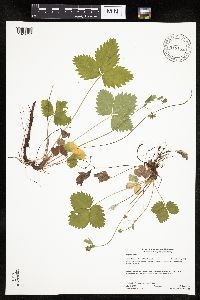 918157[1026757]Gerdes, Lynden; et al. 57442009-06-16 United States, Minnesota, Cook, Boundary Waters Canoe Area Wilderness / Superior National Forest. T65N R01E S21 SWSWNWSE Cook County...Superior National Forest. Boundary Waters Canoe Area Wilderness. Watab Lake Cliff...NAD 83 / 698463 / 5330522. 065N 01E 21, 48.0969444 -90.3344444 |
MIN:Plants | 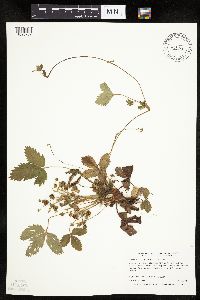 479313[1026752]Boe, J. 970625071997-06-25 United States, Minnesota, Aitkin, Aitkin Co.; McGregor Airport; T 48N R 23W NW1/4 of NW1/4 of Sec 30;;048N;23W;30, 46.621325 -93.314103 |
MIN:Plants | 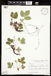 432234[1026733]Gerdes, Lynden; et al. 34291999-06-12 United States, Minnesota, Cook, Boundary Waters Canoe Area Wilderness / Superior National Forest. T65N R02E S23SENE. Cook County...Superior National Forest, BWCAW. At the far eastern end of Mountain Lake; on the south side of Moose Mountain.. 065N 02E 23, 48.100104 -90.155493 |
MIN:Plants | 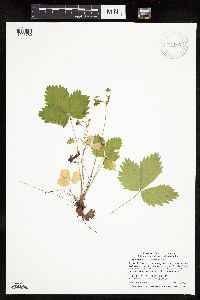 907052[1026780]Smith, Welby 308892008-06-12 United States, Minnesota, Benton, Sartell Wildlife Management Area. Benton County...Sartell State Wildlife Management Area, about 5 miles southeast of Royalton...T38N R31W NW1/4 of SW1/4 of Sec 15. 038N 31W 15, 45.7838889 -94.1927778 |
MIN:Plants | 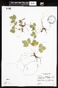 493928[1026831]Gerdes, Lynden 40302000-07-06 United States, Minnesota, Lake, North Shore. T57N R07W S24NESE Lake County ... Little Marais, MN. Small north-facing cliff feature approximately 1/4 mile SE of the Superior Hiking Trail and County 6 junction. Approx. 1/2 mile SE of the Finland Cemetary.. 057N 07W 24, 47.410745 -91.110162 |
MIN:Plants | 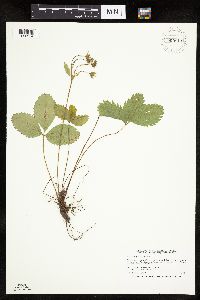 Fragaria virginiana Duchesne 909813[1026954]Smith, Welby 245991994-07-11 United States, Minnesota, Koochiching, Koochiching County...About 3 mi east of Northome...south side of Tuefer Lake...T151N R28W SW1/4 of NE1/4 of Sec 27;;151N;28W;27, 47.8694444 -94.2183333 |
MIN:Plants | 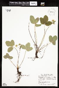 Fragaria virginiana Duchesne 907269[1027183]Smith, Welby 284272000-05-15 United States, Minnesota, Anoka, Anoka County...In the City of Blaine, just south of 95th street, and east of I35W...T 31N R 23W SW1/4 of SW1/4 of Sec 26;;031N;23W;26, 45.14 -93.1713889 |
MIN:Plants | 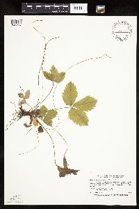 487935[1026755]Smith, Welby 167401990-05-29 United States, Minnesota, Dodge, Dodge County...About 1/2 mile east of Mantorville...South Branch Middle Fork Zumbro River...T 107N R 16W NE1/4 of NE1/4 of Sec 21. 107N 16W 21, 44.0630569 -92.7416687 |
MIN:Plants | 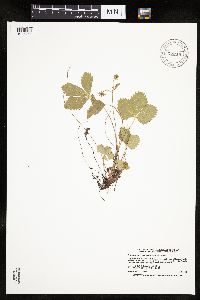 918218[1026756]Smith, Welby 223901993-06-09 United States, Minnesota, Otter Tail, Inspiration Peak Scenic Wayside Park. Otter Tail County ... Inspiration Peak State Wayside Park, about 12 miles west of Parkers Prairie ... T131N R39W SE1/4 of SW1/4 of Sec 22. 131N 39W 22, 46.1383333 -95.5736111 |
MIN:Plants | Fragaria virginiana Duchesne 931708[]Smith, Welby R. 202981992-06-02 United States, Minnesota, Redwood, On a gentle north-facing slope in the Minnesota River Valley, about 3 miles northeast of Belview NE of NW of section;;114N;37W;27, 44.6563889 -95.2977778 |
MIN:Plants | Fragaria virginiana Duchesne 936031[]Smith, Welby R. 323712011-05-23 United States, Minnesota, Scott, about 6 miles E-NE of New Prague. NW of SE of section;Bradshaw Lake State Wildlife Management Area;113N;22W;16, 44.5910833 -93.47065 |
MIN:Plants | 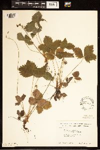 553995[1284160]Moore, John 224821955-06-01 United States, Minnesota, Renville, Long Lake;;;;, 44.689811 -95.318356 |
MIN:Plants | 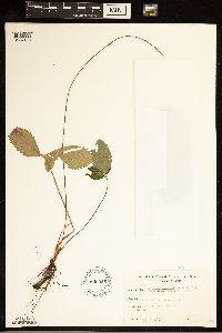 Fragaria virginiana subsp. grayana (E. Vilmorin ex J. Gay) Staudt 606925[1284193]Davidson, Donald s.n.1966-09-01 United States, Wisconsin, Douglas, Wisconsin Point, Superior |
MIN:Plants | 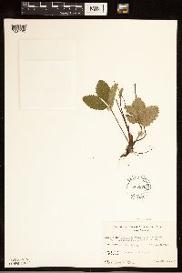 Fragaria virginiana subsp. grayana (E. Vilmorin ex J. Gay) Staudt 606970[1284192]Davidson, Donald s.n.1967-06-22 United States, Wisconsin, Douglas, Wisconsin Point, Superior |
Google Map
Google Maps is a web mapping service provided by Google that features a map that users can pan (by dragging the mouse) and zoom (by using the mouse wheel). Collection points are displayed as colored markers that when clicked on, displays the full information for that collection. When multiple species are queried (separated by semi-colons), different colored markers denote each individual species.