University of Minnesota
http://www.umn.edu/
612-625-5000
http://www.umn.edu/
612-625-5000
Minnesota Biodiversity Atlas
Bell Museum
Dataset: MIN-Plants
Taxa: Myricaceae
Search Criteria: excluding cultivated/captive occurrences
Bell Museum plants | |
 MIN:Plants | Myrica gale L. 96921[]Sandberg, John s.n.1891-06-00 United States, Minnesota, Saint Louis, St Louis Co.;;;;, 47.739511 -92.362392 |
MIN:Plants | Myrica gale L. 96922[]Arthur, J.; et al. B131886-07-18 United States, Minnesota, Saint Louis, Vermilion Lake;;;;, 47.875003 -92.334552 |
MIN:Plants | Myrica gale L. 590535[]US Nat. Arboretum staff 77-1311977-00-00 Canada, Quebec, Parc de la Verendrye |
MIN:Plants | Myrica gale L. 443483[]Abbott, Robinson s.n.1963-07-19 United States, Minnesota, Cook, Cook County; off Gunflint Trail, c.11 mi. N. of Grand Marais.;Superior National Forest;062N;02E;, 47.8453519 -90.1894692 |
MIN:Plants | Myrica gale L. 491232[]Smith, Welby 292792002-05-23 United States, Minnesota, Lake, North Shore. Lake County ... Along County Road 7, five miles east of junction with Hwy 1 in Finland ... Baptism River ... T 57N R 7W NE1/4 of SW1/4 of Sec 1. 057N 07W 1, 47.4513893 -91.1630554 |
MIN:Plants | Myrica gale L. 916995[]Smith, Welby; et al. 312922009-06-25 United States, Minnesota, Cook, Boundary Waters Canoe Area Wilderness / Superior National Forest. Cook County...Boundary Waters Canoe Area Wilderness, Superior National Forest. On the west side of Cross Bay Lake... about 0.5 mile south of Ham Lake...T 64N R 4W NE1/4 of NW1/4 of Sec 2. 064N 04W 2, 48.0602778 -90.8036111 |
MIN:Plants | Myrica gale L. 896959[]Lake, Roger 00-12000-01-02 United States, Minnesota, Itasca, Itasca County...near outlet of Stingy Lake...T 59N R 22W NE1/4 of NW1/4 of Sec 15;George Washington State Forest;059N;22W;15, 47.5960603 -93.1178064 |
MIN:Plants | Myrica gale L. 508091[]Gerdes, Lynden; et al. 24741998-05-23 United States, Minnesota, Cook, T64N R03E S03NENW. Cook County ... Superior National Forest, BWCAW. Near west end of John Lake/Royal River portage.;Boundary Waters Canoe Area Wilderness / Superior National Forest;064N;03E;3, 48.0574761 -90.04601 |
MIN:Plants | Myrica gale L. 454690[]Lee, Michael MDL16111996-09-12 United States, Minnesota, Carlton, Jay Cooke State Park. Carlton County ... Jay Cooke State Park 1/4 mile southwest of Thomson. ... along the St. Louis River gorge 1/4 mile downstream from the mouth of Otter Creek. ... T48N R16W NW1/4 NW1/4 Sec. 8. 048N 16W 8, 46.6560746 -92.3961854 |
MIN:Plants | Myrica gale L. 908351[]Smith, Welby; et al. 310722008-08-05 United States, Minnesota, Saint Louis, Boundary Waters Canoe Area Wilderness / Superior National Forest. St. Louis County...Along the shore of Clark Lake in the Boundary Waters Canoe Area Wilderness, Superior National Forest...T 63N R 14W NE1/4 of SW1/4 of Sec 23. 063N 14W 23, 47.9213889 -92.0877778 |
MIN:Plants | Myrica gale L. 931167[]Gerdes, Lynden B. 62442011-05-12 United States, Minnesota, Lake, Snake Creek entry point. Approximately 13.5 miles NW of Isabella, MN. North off the portage. SWSESESW of section;Superior National Forest;061N;09W;7, 47.7736111 -91.5258333 |
MIN:Plants | Myrica gale L. 931470[]Gerdes, Lynden B. 64722011-05-11 United States, Minnesota, Lake, Superior National Forest. Snake Creek entry point. Approximately 13.5 miles NW of Isabella, MN. North off the portage. SWSESESW. 061N 09W 7, 47.7736111 -91.5258333 |
MIN:Plants | Myrica gale L. 934079[]Smith, Welby R. 33483 United States, Minnesota, Koochiching, About 19 miles east of Waskish. SW of SW of section;Pine Island State Forest;154N;27W;22, 48.1372 -94.1009333 |
MIN:Plants | Myrica gale L. 935376[]Smith, Welby R; Gerdes, Lynden B 332902011-08-09 United States, Minnesota, Lake, At the west end of Lake Isabella where it joins the Isabella River. SE of NW of section;Boundary Waters Canoe Area Wilderness / Superior National Forest;062N;07W;31, 47.8108667 -91.2675167 |
MIN:Plants | Myrica gale L. 936352[]Smith, Welby R; Milburn, Scott 329002011-06-26 United States, Minnesota, Lake of the Woods, about 16 miles S-SE of Faunce. SE of NW of section;Red Lake State Wildlife Management Area;157N;33W;25, 48.3890333 -94.832 |
MIN:Plants | Myrica gale L. 939634[]Smith, Welby R. 321262010-08-29 United States, Minnesota, Cook, About 12 miles north of Tofte on Highway 2. Bank of Temperance River. SW of SE of section;Superior National Forest;061N;04W;30, 47.7331265 -90.8799058 |
MIN:Plants | Myrica gale L. 796368[]Smith, Welby R.; Gerdes, Lynden B. 317742010-06-25 United States, Minnesota, Cook, A short distance north of Banadad Lake. SW of NE of section;Boundary Waters Canoe Area Wilderness / Superior National Forest;064N;03W;10, 48.042463 -90.6791359 |
MIN:Plants | 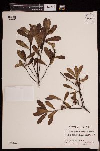 Myrica gale L. 939236[1290038]Lake, Roger 99-231999-09-25 United States, Minnesota, Saint Louis, NE of SW of section; T059N R21W sec13, 47.5946663 -92.9440165 |
MIN:Plants | 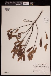 Myrica gale L. 939238[1290040]Lake, Roger 99-251999-10-09 United States, Minnesota, Itasca, on shore of Snowball lake, within 50 m north of US 169 roadside rest pavement SW of SW of section; T056N R23W sec14, 47.3338809 -93.2260377 |
MIN:Plants | 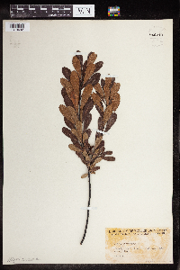 Myrica gale L. 960213[1318492]Friesner, Ray C. 102301936-08-10 United States, Maine, Waldo, Megunticook Lake |
MIN:Plants | 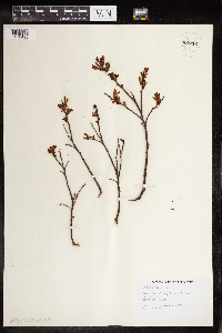 Myrica gale L. 960212[1318493]Eyerdam, Walter 1948-06-20 United States, Alaska, Port San Juan, Evans island |
MIN:Plants |  Myrica gale L. 976694[1402302]Timothy J. S. Whitfeld 29502021-07-18 United States, Minnesota, St. Louis, Voyageurs National Park, small, low island along south shore of Namakan Lake, 48.422653 -92.574999, 339m |
MIN:Plants |  Myrica gale L. 968106[1368647]Timothy J. S. Whitfeld 12122016-04-24 United States, Rhode Island, Washington, Chipuxet River, 0.1 mile southwest of intersection between Route 138 and Route 110., 41.4815 -71.557209 |
MIN:Plants |  Myrica gale L. 971299[1394776]M. H. Nee 658332020-06-25 United States, Wisconsin, Lincoln, Edge of Wisconsin River along Hwy. 107, 0.5 km above (NNE) of Grandfather Dam. T 33 N; R 6 E; SW¼NE¼ sect. 30., 45.3175 -89.7825, 430m |
MIN:Plants |  Myrica gale L. 972598[1398148]Janssens, J. 75/4571975-08-17 Belgium |
MIN:Plants | 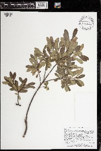 Myrica gale L. 973577[1397131]Lee, Michael MDL57192011-08-28 United States, Minnesota, Lake, Boundary Waters Canoe Area Wilderness; Rugged bedrock terrain south of Knife Lake, 31 miles east-northeast of Ely, on the southwest side of Bonnie Lake., 48.08149771 -91.22115556, 425m |
MIN:Plants | Myrica heterophylla Rafinesque 590534[]US Nat. Arboretum staff 1421978-00-00 United States, Virginia, Surry, Surrey Co. [sic] |
MIN:Plants | 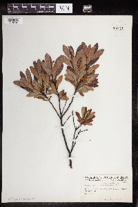 Myrica heterophylla Rafinesque 960211[1318494]Friesner, Ray C. 90491935-08-17 United States, Maine, Waldo, Megunticook Lake |
MIN:Plants | 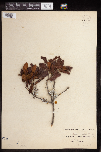 Myrica heterophylla Rafinesque 960210[1318495]Mowery, May 1928-08-29 United States, Massachusetts, woods hole and vicinity, West Falmouth |
MIN:Plants | Comptonia peregrina (L.) J.M. Coulter 493677[]Smith, Welby 276901999-05-08 United States, Minnesota, Pine, General C C Andrews State Forest. Pine County ... General C.C. Andrews State Forest, about 2.5 miles E of Willow River (town) ... T44N R19W NW1/4 of SW1/4 of Sec 5. 044N 19W 5, 46.3241653 -92.7813873 |
MIN:Plants | Comptonia peregrina (L.) J.M. Coulter 438289[]Schimpf, D. DJS3942005-06-09 United States, Minnesota, Saint Louis, St. Louis County, Midway Township. T49N R15W Sec 32 & 33. Boundary between Sec 32 & 33...former railroad grade.;;049N;15W;32, 46.6838875 -92.2586136 |
MIN:Plants | Comptonia peregrina (L.) J.M. Coulter 273170[]Rosendahl, C. s.n.1929-09-06 United States, Minnesota, Hubbard, 4-5 mi W of La Porte;;N;;, 47.216015 -94.837187 |
MIN:Plants | Comptonia peregrina (L.) J.M. Coulter 276819[]Huff, N. 1381914-07-14 United States, Minnesota, Lake, Gabbro Lake;;N;;, 47.853902 -91.588559 |
MIN:Plants | Comptonia peregrina (L.) J.M. Coulter 276856[]Huff, N. s.n.1929-07-20 United States, Minnesota, Itasca, [no further data];;;;, 47.431463 -93.58443 |
MIN:Plants | Comptonia peregrina (L.) J.M. Coulter 292029[]Moyle, J. 7601933-07-07 United States, Minnesota, Hubbard, Along Jeff Hwy 4 mi S of Park [Itasca SP];;N;;, 47.078586 -95.151219 |
MIN:Plants | Comptonia peregrina (L.) J.M. Coulter 293098[]Lakela, Olga 10671934-07-26 United States, Minnesota, Saint Louis, Bass Lake;Superior National Forest;063N;12W;, 47.9330924 -91.861065 |
MIN:Plants | Comptonia peregrina (L.) J.M. Coulter 332352[]Roberts, Thomas s.n.1925-07-00 United States, Minnesota, Saint Louis, Burntside Lake;Superior National Forest;063N;13W;, 47.93205 -91.98786 |
MIN:Plants | Comptonia peregrina (L.) J.M. Coulter 353450[]Lakela, Olga 23821938-05-23 United States, Minnesota, Carlton, Cloquet Forestry Station;;N;;, 46.704909 -92.525194 |
MIN:Plants | Comptonia peregrina (L.) J.M. Coulter 353543[]Lakela, Olga 26011938-07-28 United States, Minnesota, Saint Louis, about 6 mi NE of Palo;;057N;15W;, 47.4153244 -92.2397132 |
MIN:Plants | Comptonia peregrina (L.) J.M. Coulter 355904[]Lakela, Olga 30351939-06-24 United States, Minnesota, Saint Louis, on Hwy 20, about 8 mi S of Biwabik;;N;;, 47.444124 -92.341552 |
MIN:Plants | Comptonia peregrina (L.) J.M. Coulter 356962[]Stevenson, J. 3891912-08-30 United States, Minnesota, Itasca, Grand Rapids;;055N;25W;, 47.2155475 -93.5229868 |
MIN:Plants | Comptonia peregrina (L.) J.M. Coulter 360144[]Rosendahl, C.; Butters, F. 68871937-08-27 United States, Minnesota, Lake, About 20 mi SE from Ely;;N;;, 47.698143 -91.561753 |
MIN:Plants | Comptonia peregrina (L.) J.M. Coulter 367146[]Moore, John; Butters, F. 134471940-09-03 United States, Minnesota, Carlton, along wood road; 8 mi E of Barnum;;N;;, 46.502878 -92.520266 |
MIN:Plants | Comptonia peregrina (L.) J.M. Coulter 368764[]Lakela, Olga 45691941-07-24 United States, Minnesota, Saint Louis, Meander Lake on Echo Trail;Superior National Forest;N;;, 48.134238 -92.144716 |
MIN:Plants | Comptonia peregrina (L.) J.M. Coulter 370139[]Moore, John; et al. 141181941-05-24 United States, Minnesota, Pine, N side of hwy 48, 9 mi E of Hinckley;;;;, 46.014846 -92.751252 |
MIN:Plants | Comptonia peregrina (L.) J.M. Coulter 372401[]Lakela, Olga 45241941-07-21 United States, Minnesota, Saint Louis, near Idington on Hwy 53;;;;, 47.733255 -92.651845 |
MIN:Plants | Comptonia peregrina (L.) J.M. Coulter 374093[]Lakela, Olga 52011942-08-30 United States, Minnesota, Saint Louis, S of Kerrick, Hwy 23;;N;;, 46.711113 -92.250669 |
MIN:Plants | Comptonia peregrina (L.) J.M. Coulter 383390[]Moore, John; Hall, Robert 161291943-09-08 United States, Minnesota, Lake, 3 mi from Snow Bank Lake on the Ely - Fernberg Road;;N;;, 47.955974 -91.493981 |
MIN:Plants | Comptonia peregrina (L.) J.M. Coulter 405083[]Rosendahl, C. 78781947-09-23 United States, Minnesota, Carlton, SE Carlton Co. along hwy 23;;N;;, 46.545195 -92.363943 |
MIN:Plants | Comptonia peregrina (L.) J.M. Coulter 407094[]Lakela, Olga 89791949-07-14 United States, Minnesota, Saint Louis, Echo Trail N of Ely;Superior National Forest;N;;, 48.116014 -92.14764 |
MIN:Plants | Comptonia peregrina (L.) J.M. Coulter 407353[]Lakela, Olga 85421949-06-26 United States, Minnesota, Saint Louis, Ely - Finland Road near White Iron Lake, SE of Ely;Superior National Forest;062N;12W;, 47.8460516 -91.8609892 |
MIN:Plants | Comptonia peregrina (L.) J.M. Coulter 407628[]Lakela, Olga 83931949-06-20 United States, Minnesota, Saint Louis, Along rr tracks, Armstrong Lake;;062N;14W;, 47.8446095 -92.1153493 |
MIN:Plants | Comptonia peregrina (L.) J.M. Coulter 418882[]Ahlgren, Clifford 4851949-00-00 United States, Minnesota, Lake, Quetico-Superior Wilderness Research Center...Lake Co, Sec 9, T64N, R10W;Boundary Waters Canoe Area Wilderness / Superior National Forest;064N;10W;09, 48.0316509 -91.6188616 |
MIN:Plants | Comptonia peregrina (L.) J.M. Coulter 419521[]Lakela, Olga 116371950-08-23 United States, Minnesota, Saint Louis, St. Louis County...Iron Lake across the portage from Crooked Lake;Boundary Waters Canoe Area Wilderness / Superior National Forest;066N;12W;06, 48.2307941 -91.9170265 |
MIN:Plants | Comptonia peregrina (L.) J.M. Coulter 421533[]Ahlgren, Clifford 10281950-08-22 United States, Minnesota, Saint Louis, Campgrounds, Curtain Falls Resort, Crooked Lake;Boundary Waters Canoe Area Wilderness / Superior National Forest;066N;12W;, 48.1867867 -91.8699675 |
MIN:Plants | Comptonia peregrina (L.) J.M. Coulter 426130[]Marion, J. s.n.1982-00-00 United States, Minnesota, Cook, North Shore of Lake Superior, ca. 200 ft from lakeshore;North Shore;N;;, 47.762747 -90.286357 |
MIN:Plants | Comptonia peregrina (L.) J.M. Coulter 427889[]Carter, J.; et al. s.n.1981-06-15 United States, Minnesota, Saint Louis, County: St. Louis; in disturbed portage area ... R-12W T-64N Section 26;Superior National Forest;064N;12W;26, 47.9985869 -91.8321123, 411m |
MIN:Plants | Comptonia peregrina (L.) J.M. Coulter 442523[]Lakela, Olga 133201951-07-17 United States, Minnesota, Saint Louis, Ash River about 2 mi down steam from the Frontier Lodge;Kabetogama State Forest;068N;19W;00, 48.3680607 -92.7740534 |
MIN:Plants | Comptonia peregrina (L.) J.M. Coulter 443007[]Lakela, Olga 124921951-06-19 United States, Minnesota, Saint Louis, Boundary Waters Canoe Area Wilderness / Superior National Forest. St. Louis County...Iron Lake woods below Curtain Falls Iron Lake woods below Curtain Falls. 066N 12W 6, 48.2307941 -91.9170265 |
MIN:Plants | Comptonia peregrina (L.) J.M. Coulter 443328[]Lakela, Olga 128571951-06-28 United States, Minnesota, Saint Louis, Little Vermilion River, Minnesota - Ontario boundary;Superior National Forest;067N;16W;, 48.2689005 -92.4286583 |
MIN:Plants | Comptonia peregrina (L.) J.M. Coulter 448656[]Moore, John; Huff, N. 193221946-09-26 United States, Minnesota, Saint Louis, McCarthy Beach State Memorial Park;McCarthy Beach State Park;060N;21W;, 47.675918 -92.9968028 |
MIN:Plants | Comptonia peregrina (L.) J.M. Coulter 449083[]Moore, John; Hall, Robert 168181944-08-03 United States, Minnesota, Crow Wing, Along hwy 6 N of Crosby;;N;;, 46.482185 -93.957761 |
MIN:Plants | Comptonia peregrina (L.) J.M. Coulter 453558[]Myhre, K. 50331994-06-18 United States, Minnesota, Itasca, Itasca Co.; located 2 miles south of the town of Talmoon; T 59N R 27W SE1/4 of SE1/4 of Sec 27;Chippewa National Forest;059N;27W;27, 47.5659994 -93.7597498 |
MIN:Plants | Comptonia peregrina (L.) J.M. Coulter 462680[]Lakela, Olga 144181952-06-23 United States, Minnesota, Saint Louis, St. Louis County...Hammer Creek portage about 3 mi from Namakan Narrows;Voyageurs National Park;069N;17W;33, 48.4202631 -92.5177717 |
MIN:Plants | Comptonia peregrina (L.) J.M. Coulter 462930[]Lakela, Olga 150741952-07-16 United States, Minnesota, Saint Louis, Lost Bay N shore of Kabetogama Lake;Voyageurs National Park;N;;, 48.46371 -92.855769 |
MIN:Plants | Comptonia peregrina (L.) J.M. Coulter 463462[]Lakela, Olga 141121952-06-16 United States, Minnesota, Saint Louis, Namakan Narrows;Voyageurs National Park;069N;17W;, 48.4282435 -92.5270181 |
MIN:Plants | Comptonia peregrina (L.) J.M. Coulter 491729[]Lakela, Olga 169191953-09-01 United States, Minnesota, Saint Louis, St. Louis County...Trout Lake portage N of Vermilion Lake;Boundary Waters Canoe Area Wilderness / Superior National Forest;063N;16W;24, 47.9243525 -92.3193738 |
MIN:Plants | Comptonia peregrina (L.) J.M. Coulter 491850[]Lakela, Olga 167971953-08-10 United States, Minnesota, Saint Louis, Lac La Croix at Beatty portage;Boundary Waters Canoe Area Wilderness / Superior National Forest;067N;15W;20, 48.27403 -92.2871 |
MIN:Plants | Comptonia peregrina (L.) J.M. Coulter 492905[]Lakela, Olga; et al. 164031953-07-27 United States, Minnesota, Lake, E shore Pipestone Bay.;Boundary Waters Canoe Area Wilderness / Superior National Forest;064N;11W;00, 48.0185912 -91.734178 |
MIN:Plants | Comptonia peregrina (L.) J.M. Coulter 526897[]Lakela, Olga 179931954-07-24 United States, Minnesota, Saint Louis, Gun Lake S shore, N of Ely;Boundary Waters Canoe Area Wilderness / Superior National Forest;065N;12W;, 48.110531 -91.830312 |
MIN:Plants | Comptonia peregrina (L.) J.M. Coulter 526937[]Lakela, Olga 176531954-07-24 United States, Minnesota, Saint Louis, Above Burntside Lake, N side, Ely;Superior National Forest;063N;13W;00, 47.9320528 -91.9878633 |
MIN:Plants | Comptonia peregrina (L.) J.M. Coulter 527315[]Lakela, Olga 173501954-06-08 United States, Minnesota, Saint Louis, Near Vermilion River dam on Vermilion Lake terrace;Superior National Forest;N;;, 47.960901 -92.476224 |
MIN:Plants | Comptonia peregrina (L.) J.M. Coulter 532744[]Lakela, Olga 27381956-08-09 United States, Minnesota, Saint Louis, St. Louis County...Waugoosh [=Wagosh] Lake portage from Gun Lake, N of Ely;Boundary Waters Canoe Area Wilderness / Superior National Forest;065N;12W;00, 48.1079901 -91.8646433 |
MIN:Plants | Comptonia peregrina (L.) J.M. Coulter 532981[]Lakela, Olga 202531956-07-02 United States, Minnesota, Saint Louis, along Clear Lake Road N of Virginia;;;;, 47.638006 -92.755001 |
MIN:Plants | Comptonia peregrina (L.) J.M. Coulter 543475[]Lakela, Olga 221891957-08-20 United States, Minnesota, Lake, Endless Waters Trail, Kawishiwi River Range;Superior National Forest;N;;, 47.816669 -91.721765 |
MIN:Plants | Comptonia peregrina (L.) J.M. Coulter 669843[]Wheeler, Gerald s.n.1975-07-12 United States, Minnesota, Lake, Approx. 12 mi SE of the jnc of hwy 1 and the Kawishiwi River; about 1/2 the distance between Ely and Isabella;Superior National Forest;N;;, 47.718488 -91.598947 |
MIN:Plants | Comptonia peregrina (L.) J.M. Coulter 669848[]Wheeler, Gerald s.n.1974-06-22 United States, Minnesota, Aitkin, Approc. 3 mi S of Hill City; 2 mi E of Hwy 169 on Willow River Road, NW of Willow River Bog;Hill River State Forest;N;;, 46.947474 -93.580025 |
MIN:Plants | Comptonia peregrina (L.) J.M. Coulter 671254[]Morley, T. 12981976-07-15 United States, Minnesota, Hubbard, Start at N edge of hwy 200 at a small road 0.95 mi E of co. rd 4 (Lake George road); walk 65 steps NNW.;;N;;, 47.210561 -94.939702 |
MIN:Plants | Comptonia peregrina (L.) J.M. Coulter 672764[]Wheeler, Gerald 9071976-08-19 United States, Minnesota, Carlton, Approx. 2 mi SW of the Cloquet Forestry Station;;N;;, 46.703689 -92.493755 |
MIN:Plants | Comptonia peregrina (L.) J.M. Coulter 687481[]Wheeler, Gerald; Glaser, Paul 19231977-07-07 United States, Minnesota, Itasca, Coll. site no. 91; E1/2 NE1/4 Sec 31, T61N, R22W; ca 38 mi NE of Grand Rapids;George Washington State Forest;061N;22W;31, 47.7281544 -93.2000119 |
MIN:Plants | Comptonia peregrina (L.) J.M. Coulter 687829[]Wheeler, Gerald; Glaser, Paul 22751977-07-26 United States, Minnesota, Itasca, Coll. site no. 149; SE1/4 SE1/4 Sec 28, T54N, R24W; ca 8.5 mi S-SE of Grand Rapids;;054N;24W;28, 47.1308396 -93.3958203 |
MIN:Plants | Comptonia peregrina (L.) J.M. Coulter 699045[]Sather, Nancy; et al. 671976-06-11 United States, Minnesota, Lake, Lake Co. NW1/4 S26, T62N, R11W, Spruce Road;Superior National Forest;062N;11W;26, 47.8269798 -91.693362 |
MIN:Plants | Comptonia peregrina (L.) J.M. Coulter 708888[]Wheeler, Gerald 38761979-06-13 United States, Minnesota, Pine, Pine Co. Approx. 3 mi E of Willow River, about 0.5 mi E of McCormick Lake. T44N, R19W, Sec 8.;;044N;19W;8, 46.3097235 -92.7724393 |
MIN:Plants | Comptonia peregrina (L.) J.M. Coulter 708944[]Wheeler, Gerald 39321979-06-18 United States, Minnesota, Pine, Pine Co. Approx. 1.5 mi E of Cloverdale on Hwy 48, just S of the road. T41N, R19W, Sec 26.;;041N;19W;26, 46.0044237 -92.709858 |
MIN:Plants | Comptonia peregrina (L.) J.M. Coulter 709441[]Wheeler, Gerald 44341979-07-20 United States, Minnesota, Carlton, Approx. 5 mi SW of Holyoke, adjacent to Rte 23. T46N, R17W, Sec 34.;;046N;17W;34, 46.4251273 -92.4773931 |
MIN:Plants | Comptonia peregrina (L.) J.M. Coulter 726369[]Smith, Welby 25221980-06-14 United States, Minnesota, Carlton, T46N, R17W; NW1/4 NE1/4 Sec 26. On the E side of hwy 23.;;046N;17W;26, 46.4394807 -92.4564582 |
MIN:Plants | Comptonia peregrina (L.) J.M. Coulter 729473[]Cutler, S. 861980-06-16 United States, Minnesota, Pine, Pine Co. St. Croix Natural Area: 21 mi E of Hinckley. NW1/4 SW1/4 Sec 33, T41N, R17W.;Saint Croix State Park;041N;17W;33, 45.9905189 -92.4984007 |
MIN:Plants | Comptonia peregrina (L.) J.M. Coulter 764647[]Ballard, C. s.n.1893-07-00 United States, Minnesota, Cass, Gull Lake;;N;;, 46.444486 -94.362663 |
MIN:Plants | Comptonia peregrina (L.) J.M. Coulter 773068[]Boe, J. 18481981-08-28 United States, Minnesota, Lake of the Woods, SE of Brown's Lake. S slope. NW1/4 SW1/4 Sec 22, R35W, T159N;Beltrami Island State Forest;159N;35W;22, 48.5763627 -95.1373969 |
MIN:Plants | Comptonia peregrina (L.) J.M. Coulter 774345[]Monson, Paul 53041983-06-14 United States, Minnesota, Saint Louis, Voyageurs National Park. R20W, T69N, SW1/4 NW1/4, S25, Kabetogama Narrows Ranger Station.;Voyageurs National Park;069N;20W;25, 48.43325 -92.8423223 |
MIN:Plants | Comptonia peregrina (L.) J.M. Coulter 774393[]Monson, Paul 55691983-07-21 United States, Minnesota, Saint Louis, Voyageurs National Park...St. Louis Co. R-19W, T-69N, S-34. Namakan Lake, Hoist Bay. Inland from W shore.;Voyageurs National Park;069N;19W;34, 48.4186779 -92.7563784 |
MIN:Plants | Comptonia peregrina (L.) J.M. Coulter 774445[]Monson, Paul 55801983-07-21 United States, Minnesota, Saint Louis, Voyageurs National Park, R17W, T68N, S9. Little Trout Lake. SW shore and portage to Grassy Bay.;Voyageurs National Park;068N;17W;9, 48.3884147 -92.5313613 |
MIN:Plants | Comptonia peregrina (L.) J.M. Coulter 818197[]Engels, A.; et al. s.n.1991-07-29 United States, Minnesota, Aitkin, Aitkin Co. T51N, R26W, S23 NW1/4 NW1/4, ca 1/2 mi E of gen. hwy 169 and co. rd 7, on dirt road paralleling Willow River.;Hill River State Forest;051N;26W;23, 46.8922906 -93.6034353 |
MIN:Plants | Comptonia peregrina (L.) J.M. Coulter 835534[]Monson, Paul 55691983-07-21 United States, Minnesota, Saint Louis, Voyageur's National Park. St. Louis Co. R-19W, T-69N, S-34. Namakan Lake, Hoist Bay. Inland from W shore.;Voyageurs National Park;069N;19W;34, 48.4186779 -92.7563784 |
MIN:Plants | Comptonia peregrina (L.) J.M. Coulter 840464[]Boe, J. 930630051993-06-30 United States, Minnesota, Cass, Cass Co. Trail S of Morrison Lake; T139N R25W SW1/4 of SE1/4 of Sec 30.;;139N;25W;30, 46.8250506 -93.8917567 |
MIN:Plants | Comptonia peregrina (L.) J.M. Coulter 96854[]Butters, F.; et al. s.n.1928-05-31 United States, Minnesota, Carlton, [no further data];;;;, 46.57515 -92.674683 |
MIN:Plants | Comptonia peregrina (L.) J.M. Coulter 96855[]Sandberg, John s.n.1891-08-00 United States, Minnesota, Itasca, [no further data];;;;, 47.471853 -93.623798 |
MIN:Plants | Comptonia peregrina (L.) J.M. Coulter 96856[]Ballard, C. B15701893-07-00 United States, Minnesota, Cass, Upper Gull Lake;;N;;, 46.529751 -94.344331 |
MIN:Plants | Comptonia peregrina (L.) J.M. Coulter 96857[]Arthur, J.; et al. B4091886-07-25 United States, Minnesota, Saint Louis, Burntside L, Vermilion Lake;Superior National Forest;063N;13W;00, 47.9320528 -91.9878633 |
MIN:Plants | Comptonia peregrina (L.) J.M. Coulter 489211[]Gerdes, Lynden 47522003-07-11 United States, Minnesota, Lake, T60N R09W S03NESW Lake County...Superior National Forest. Approx 8.14 mi NW of Isabella, MN and 0.82 mile N of Cat Lake;Superior National Forest;060N;09W;03, 47.7107563 -91.4591885 |
Google Map
Google Maps is a web mapping service provided by Google that features a map that users can pan (by dragging the mouse) and zoom (by using the mouse wheel). Collection points are displayed as colored markers that when clicked on, displays the full information for that collection. When multiple species are queried (separated by semi-colons), different colored markers denote each individual species.