University of Minnesota
http://www.umn.edu/
612-625-5000
http://www.umn.edu/
612-625-5000
Minnesota Biodiversity Atlas
Bell Museum
Dataset: MIN-Plants
Taxa: Myricaceae
Search Criteria: excluding cultivated/captive occurrences
Bell Museum plants | |
 MIN:Plants | Comptonia peregrina (L.) J.M. Coulter 539062[]Mortensen, Carol Estes; et al. LL15531998-07-13 United States, Minnesota, Cass, Leech Lake Reservation and Chippewa National Forest...Found in a jackpine stand owned by Potlatch...T145N, R30W, NENE23;Chippewa National Forest / Leech Lake Indian Reservation;145N;30W;23, 47.3601151 -94.447764 |
MIN:Plants | Comptonia peregrina (L.) J.M. Coulter 438154[]Smith, Welby 275031998-08-11 United States, Minnesota, Koochiching, Koochiching County...Abut two miles north of Big Falls (town)...T 155N R 25W NW1/4 of NE1/4 of Sec 26;Pine Island State Forest;155N;25W;26, 48.2230568 -93.8019409 |
MIN:Plants | Comptonia peregrina (L.) J.M. Coulter 438671[]Aaseng, N. 91904011991-09-04 United States, Minnesota, Roseau, Roseau County ... Beltrami Island State Forest ... NE1/4 SE1/4 Sec. 30 T161N R36W;Beltrami Island State Forest;161N;36W;30, 48.7347607 -95.341223 |
MIN:Plants | Comptonia peregrina (L.) J.M. Coulter 910593[]Lee, Michael MDL43762007-06-13 United States, Minnesota, Wadena, Wadena County...Along County Highway 23...1.5 miles north of State Highwy 227, 3.5 miles east-northeast of Sebeka... T137N R34W W1/2 of NW1/4 of SW1/4 Sec.29, E1/2 of NE1/4 of SE1/4 Sec. 30. 137N 34W 0, 46.651665 -95.0277167 |
MIN:Plants | Comptonia peregrina (L.) J.M. Coulter 897163[]Zager, S. 2822004-09-13 United States, Minnesota, Roseau, Roseau County...T 160 N R 38 W 1/4 of 1/4 NENW Section 25;Beltrami Island State Forest;160N;38W;25, 48.6530556 -95.4852778 |
MIN:Plants | Comptonia peregrina (L.) J.M. Coulter 509059[]Smith, Welby 256121995-05-15 United States, Minnesota, Pine, Saint Croix State Park. Pine County ... In St. Croix State Park, about 0.5 mile northeast of the confluence of Crooked Creek and the St. Croix River ... T 41N R 17w NW1/4 of SW1/4 of sec 33. 041n 17W 33, 45.9916649 -92.5063858 |
MIN:Plants | Comptonia peregrina (L.) J.M. Coulter 489299[]Smith, Welby 279321999-06-22 United States, Minnesota, Pine, General C C Andrews State Forest. Pine County ... General C.C. Andrews State Forest, about 2.5 miles E of Willow River (town) ... T 44N R 19W NW1/4 of SW1/4 of Sec 5. 044N 19W 5, 46.3241653 -92.7813873 |
MIN:Plants | Comptonia peregrina (L.) J.M. Coulter 561106[]US Nat. Arboretum staff 77-1291977-00-00 United States, District of Columbia, USNA [Nat. Arboretum]. cult. |
MIN:Plants | Comptonia peregrina (L.) J.M. Coulter 488069[]Smith, Welby 276121999-04-10 United States, Minnesota, Pine, Pine County ... General C.C. Andrews State Forest, about 2.5 mi E of Willow River ... T44N R19W NW1/4 of SW1/4 of Sec 5;General C C Andrews State Forest;044N;19W;05, 46.3241653 -92.7813873 |
MIN:Plants | Comptonia peregrina (L.) J.M. Coulter 428981[]Smith, Welby 276021999-04-14 United States, Minnesota, Pine, General C C Andrews State Forest. Pine County ... General C.C. Andrews State Forest, about 2.5 miles E of Willow River ... T 44N R 19W NW1/4 of SW1/4 of Sec 5. 044N 19W 5, 46.3241653 -92.7813873 |
MIN:Plants | Comptonia peregrina (L.) J.M. Coulter 456205[]Smith, Welby 275261998-08-12 United States, Minnesota, Koochiching, Koochiching County...About 3 miles east of Big Falls (town) ... T 66N R 26W SW1/4 of NW1/4 of Sec 19;Koochiching State Forest;066N;26W;19, 48.1980556 -93.7436111 |
MIN:Plants | 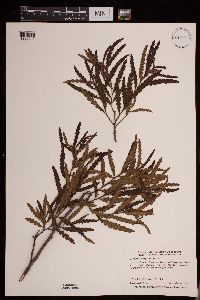 Comptonia peregrina (L.) J.M. Coulter 939231[1290046]Lake, Roger 99-171999-09-10 United States, Minnesota, Saint Louis, T055N R21W NE of NW of sec 9, 47.2604176 -93.0126213 |
MIN:Plants | 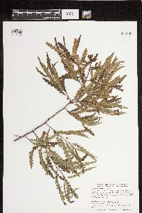 Comptonia peregrina (L.) J.M. Coulter 952988[1297502]Smith, Welby R. 28135 United States, Minnesota, Wadena |
MIN:Plants | 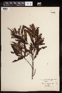 Comptonia peregrina (L.) J.M. Coulter 960209[1318496]Mowery, May 1928-08-28 United States, Massachusetts, West Falmouth |
MIN:Plants | 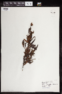 Comptonia peregrina (L.) J.M. Coulter 960208[1318497]Oliver, Elizabeth 1930-08-00 United States, Michigan |
MIN:Plants | 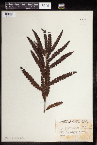 Comptonia peregrina (L.) J.M. Coulter 960207[1318498]Friesner, Ray C. 101841936-08-18 United States, Maine, Knox |
MIN:Plants | 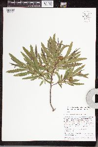 Comptonia peregrina (L.) J.M. Coulter 961103[1334247]Timothy J. S. Whitfeld 17402018-06-12 United States, Rhode Island, Providence, Diamond Hill Reservation, 0.66 miles southeast of the intersection between West Wrentham Road and Pine Swamp Road., 42.0061667 -71.4351111 |
MIN:Plants | 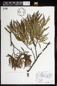 Comptonia peregrina (L.) J.M. Coulter 965403[1356266]Lee, Michael MDL53462010-08-05 United States, Minnesota, Cook, Boundary Waters Canoe Area Wilderness, Rolling to fairly rugged bedrock terrain between Swan and Bower Trout lakes, 15 miles north-northwest of Grand Marais. T63N R1W NW1/4 of NW1/4 Sec. 17, 47.94540062 -90.48751029, 524m |
MIN:Plants | 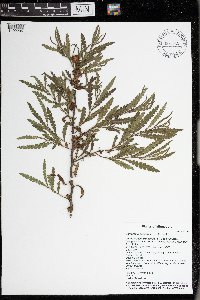 Comptonia peregrina (L.) J.M. Coulter 976615[1402206]Timothy J. S. Whitfeld 30292021-07-21 United States, Minnesota, St. Louis, Voyageurs National Park, 1.25 mile west of Grassy Bay, Sand Point Lake, 48.38647 -92.57169, 364m |
MIN:Plants | 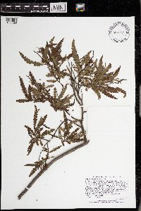 Comptonia peregrina (L.) J.M. Coulter 973037[1398590]Lee, Michael MDL59192012-06-21 United States, Minnesota, Lake, Strongly rolling bedrock terrain north of the Fernberg Road between the Moose Lake Road and Uncle Judas Creek, 16 miles east-northeast of Ely., 47.9667980709 -91.5094549642, 439m |
MIN:Plants | Myrica hartwegii S. Watson 482390[]Botti, S. 831980-11-09 United States, California, Mariposa, Yosemite National Park ... Wawona ... South Fork of the Merced River;Yosemite National Park;;;, 63.4500008 -150.8333282, 1219m |
MIN:Plants | 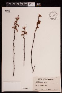 Myrica hartwegii S. Watson 461486[1290826]Botti, S. 28B1980-05-15 United States, California, Mariposa |
MIN:Plants | 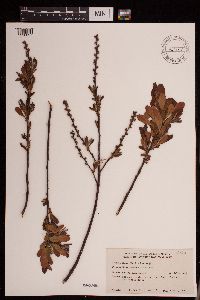 Myrica hartwegii S. Watson 461354[1290827]Botti, S. 291980-06-02 United States, California, Mariposa |
MIN:Plants | Myrica pensylvanica Mirbel 590554[]US Nat. Arboretum staff 1231974-00-00 United States, Virginia, Accomack, Accomack Co. |
MIN:Plants | Myrica pensylvanica Mirbel 590552[]Arboretum, Cary 73-461973-00-00 United States, New York, Orange, Orange Co. |
MIN:Plants | Myrica pensylvanica Mirbel 590549[]US Nat. Arboretum staff 77-1321977-00-00 United States, Maryland, Anne Arundel, [no further data] |
MIN:Plants | Myrica pensylvanica Mirbel 590553[]US Nat. Arboretum staff 1241974-00-00 Canada, Nova Scotia, Victoria Co. |
MIN:Plants | Myrica pensylvanica Mirbel 590499[]US Nat. Arboretum staff 1221974-00-00 United States, Maryland, Anne Arundel, [no further data] |
MIN:Plants | 590461[]Anonymous BKE 76-151976-00-00 United States, Florida, Volusia, [no further data] |
MIN:Plants | 560879[]US Nat. Arboretum staff 1261977-00-00 United States, Maryland, Somerset, Somerset Co. |
MIN:Plants | 560759[]US Nat. Arboretum staff 77-1301977-00-00 United States, Virginia, Accomack, Accomack Co. |
MIN:Plants | 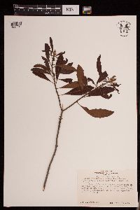 953278[1290818]Jensen, L. 2841963-03-23 United States, Florida, Walton |
MIN:Plants |  953277[1290819]Jensen, L. 2831963-03-23 United States, Florida, Walton |
MIN:Plants |  953276[1290820]Jensen, L. 2781963-03-23 United States, Florida, Walton |
MIN:Plants |  Myrica pringlei Greenman 96944[1001841]Pringle, C.G. 100021904-04-25 Mexico, Puebla, Honey Station, 1768m |
MIN:Plants |  Myrica esculenta Buch.-Ham. ex D. Don 918718[1289927]Abbe, E.C. 94411960-01-11 Thailand, Loei, Amphoe Phu Kradueng, Phudkrading (Khao Kating), 16.916667 101.783333, 1189m |
MIN:Plants | 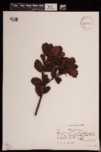 Myrica javanica Blume 905527[1289926]Bogle, A. L. 4581962-02-13 Malaysia, Sabah, Mt. Kinabalu. Just to the E of the usual route to the summit, near base of granite dome, 6.066667 116.55, 3353 - 3505m |
MIN:Plants | 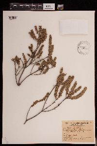 918719[1289925]Boud, P. s.n.1940-07-06 South Africa, Western Cape, Cape Town. Blaauwberg Strand |
MIN:Plants | 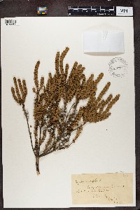 479753[1370061]Bolus, L m451940-03-03 South Africa, Hout Bay, Cape Peninsula |
MIN:Plants | 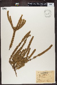 429612[1370062]P. Bond 461940-06-24 South Africa, Cape Peninsula |
MIN:Plants |  Myrica inodora W. Bartram 953275[1290821]Anderson, Loran C. 48151979-03-28 United States, Florida, Leon |
MIN:Plants |  Myrica mexicana Humb. & Bonpl. ex Willd. 960437[1318930]Greenway, P.J. 60331940-02-10 Kenya, Amani, 884m |
MIN:Plants |  Morella caroliniensis (Mill.) Small 968107[1368712]Natalie Nguyen 232016-09-23 United States, Rhode Island, Newport, Goosewing Beach, end of South Shore Road, 2.25 miles southeast of Little Compton Commons, between Tunipus and Quicksand ponds., 41.4961556 -71.1328833 |
MIN:Plants |  Myrica salicifolia Hochst. ex A. Rich. 717278[1370079]Mesfin Tadesse 4261978-07-15 Ethiopia, Shoa. 125km. W. of Addis Abeba; Swimming Pool-Ras Hotel, 2175m |
MIN:Plants | 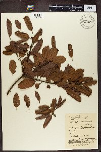 Myrica salicifolia Hochst. ex A. Rich. 460429[1370080]P.J. Greenway 59721940-07-22 Tanzania, United Republic of, Ubesi, 1158m |
MIN:Plants | 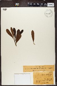 Myrica spathulata Mirb. 455284[1370081]Humblot 1921883-10-28 Comoros, NE |
MIN:Plants | 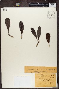 Myrica spathulata Mirb. 455201[1370082]Decary 69301930-02-08 Madagascar |
MIN:Plants | 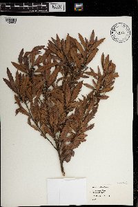 Myrica conifera Burm. f. 519481[1404402]Parker, R. N. M-561940-07-17 South Africa, Near Somerset West, Stellenbosch Div. |
Google Map
Google Maps is a web mapping service provided by Google that features a map that users can pan (by dragging the mouse) and zoom (by using the mouse wheel). Collection points are displayed as colored markers that when clicked on, displays the full information for that collection. When multiple species are queried (separated by semi-colons), different colored markers denote each individual species.