University of Minnesota
http://www.umn.edu/
612-625-5000
http://www.umn.edu/
612-625-5000
Minnesota Biodiversity Atlas
Bell Museum
Dataset: MIN-Plants
Taxa: Oleaceae
Search Criteria: excluding cultivated/captive occurrences
Bell Museum plants | |
 MIN:Plants | 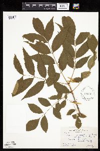 Fraxinus pennsylvanica Marshall 171660[1033959]Butters, F.; et al. 35381918-06-22 United States, Minnesota, Wabasha, Lower Zumbro Valley, Wabash County;Dorer Memorial Hardwood State Forest;;;, 44.15 -92.4667 |
MIN:Plants | 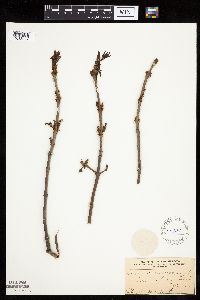 Fraxinus pennsylvanica Marshall 171661[1033837]Frost, W. s.n.1894-04-00 United States, Minnesota, Hennepin, Minnehaha Falls;Minnehaha Falls Park;028N;23W;17, 44.9118 -93.20343 |
MIN:Plants | 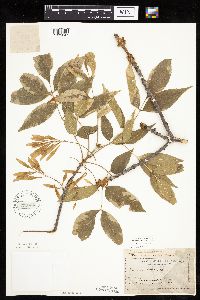 Fraxinus pennsylvanica Marshall 171662[1033847]Moyer, Lycurgus 28391894-06-00 United States, Minnesota, Chippewa, Montevideo;;117N;40W;, 44.93463 -95.67577 |
MIN:Plants |  Fraxinus pennsylvanica Marshall 171663[1033821]Holzinger, John s.n.1900-09-00 United States, Minnesota, Winona, [no further data];;;;, 44.0479 -91.6404 |
MIN:Plants | 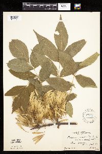 Fraxinus pennsylvanica Marshall 171665[1033848]Butters, F. s.n.1922-07-04 United States, Minnesota, Washington, Point Douglas;;026N;20W;, 44.75111 -92.81778 |
MIN:Plants |  Fraxinus pennsylvanica Marshall 171666[1033949]Menzel, Max 68451895-06-00 United States, Minnesota, Pipestone, Pipestone [assuming the quarry area; town generally noted as Pipestone City by collector];Pipestone National Monument;106N;46W;01, 44.01585 -96.31767 |
MIN:Plants |  Fraxinus pennsylvanica Marshall 171667[1034060]Rosendahl, C.; et al. 40361921-06-17 United States, Minnesota, Yellow Medicine, Granite Falls, Yellow Medicine County;;116N;39W;, 44.80937 -95.557309 |
MIN:Plants |  Fraxinus pennsylvanica Marshall 171668[1033962]Bergman, H. 28471913-07-10 United States, Minnesota, Otter Tail, Near lake, Dent;;136N;40W;, 46.58544 -95.71959 |
MIN:Plants |  Fraxinus pennsylvanica Marshall 171672[1034067]Moyer, Lycurgus s.n.1893-07-04 United States, Minnesota, Chippewa, Montevideo;;117N;40W;, 44.93463 -95.67577 |
MIN:Plants | 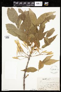 Fraxinus pennsylvanica Marshall 171673[1034066]Butters, F.; Rosendahl, C. 34081916-10-01 United States, Minnesota, Dakota, Minnesota River bottoms, near Cedar Ave bridge;;027N;23W;, 44.81875 -93.16682 |
MIN:Plants | 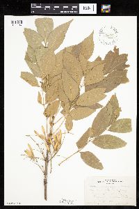 Fraxinus pennsylvanica Marshall 171674[1033947]Butters, F. s.n.1919-09-15 United States, Minnesota, Goodhue, Lake Pepin, Wacouta;;;;, 44.48769 -92.28928 |
MIN:Plants | 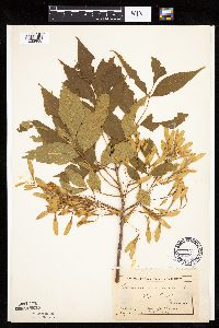 Fraxinus pennsylvanica Marshall 171675[1033908]MacMillan, C.; et al. MS10631894-07-00 United States, Minnesota, Lake of the Woods, Oak Point, L O W Co.;Pine & Curry Islands Scientific Natural Area;162N;31W;06, 48.87976 -94.69025 |
MIN:Plants | 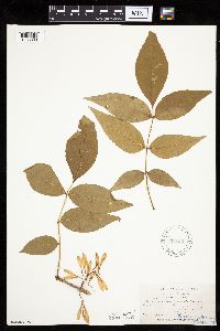 Fraxinus pennsylvanica Marshall 171677[1033809]Holzinger, John s.n.1886-06-00 United States, Minnesota, Winona, [no further data];;;;, 44.0479 -91.6404 |
MIN:Plants | 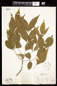 Fraxinus pennsylvanica Marshall 171678[1034006]Butters, F.; Rosendahl, C. 40811921-06-19 United States, Minnesota, Otter Tail, 14 mi E Fergus Falls;;;;, 46.28269 -95.78393 |
MIN:Plants | 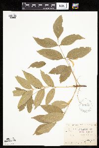 Fraxinus pennsylvanica Marshall 171679[1033999]Arthur, J.; et al. B1171886-07-17 United States, Minnesota, Saint Louis, Vermilion Lake;;;;, 47.89167 -92.36667 |
MIN:Plants | 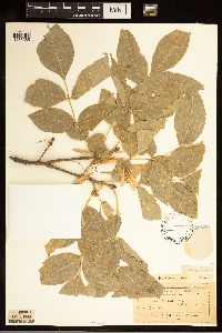 Fraxinus pennsylvanica Marshall 171680[1283385]Moyer, Lycurgus 141894-09-19 United States, Minnesota, Chippewa, [no locality given but nearly all of Moyer's collections were from Chippewa Co.];;;;, 45.022344 -95.566687 |
MIN:Plants | 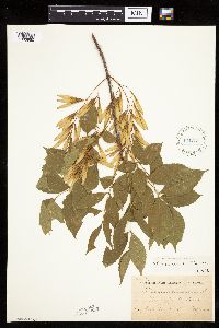 Fraxinus pennsylvanica Marshall 171681[1033950]Sheldon, Edmund S8551891-07-00 United States, Minnesota, Brown, Sleepy Eye, Brown Co.;;110N;32W;, 44.32589 -94.68476 |
MIN:Plants | 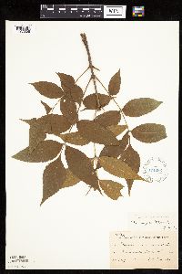 Fraxinus pennsylvanica Marshall 171682[1033896]Taylor, B. T7041891-07-00 United States, Minnesota, Faribault, Minnesota Lake;;104N;25W;, 43.80442 -93.82769 |
MIN:Plants | 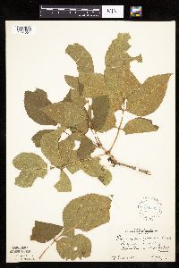 Fraxinus pennsylvanica Marshall 171683[1034004]Rosendahl, C. s.n.1925-08-08 United States, Minnesota, McLeod, W of Brownton;;115N;29W;, 44.76127 -94.31498 |
MIN:Plants | 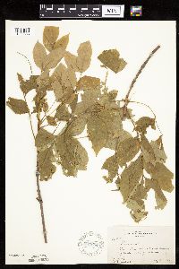 Fraxinus pennsylvanica Marshall 171684[1033886]Butters, F.; et al. 33481916-08-08 United States, Minnesota, Wright, W of Delano, Wright County;;118N;25W;, 45.04194 -93.78889 |
MIN:Plants | 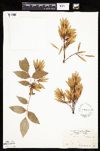 Fraxinus pennsylvanica Marshall 171685[1034024]Holzinger, John s.n.1888-09-00 United States, Minnesota, Winona, Winona;;;;, 44.05 -91.63917 |
MIN:Plants | 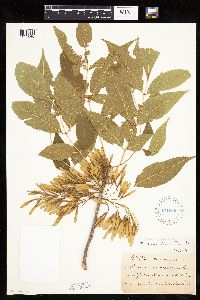 Fraxinus pennsylvanica Marshall 171686[1033846]Ballard, C. B5501891-07-00 United States, Minnesota, Scott, Spring Lake, Scott Co.;;114N;22W;, 44.70167 -93.47306 |
MIN:Plants |  Fraxinus pennsylvanica Marshall 178517[1034054]Manning, Sara s.n.1883-05-15 United States, Minnesota, Goodhue, Central Point [pioneer town on Sand Point, Lake Pepin];Frontenac State Park;112N;13W;12, 44.46861 -92.28139 |
MIN:Plants |  Fraxinus pennsylvanica Marshall 178518[1033963]Menzel, Max s.n.1895-06-00 United States, Minnesota, Pipestone, Pipestone [assuming the quarry area; town generally noted as Pipestone City by collector];Pipestone National Monument;106N;46W;01, 44.01585 -96.31767 |
MIN:Plants |  Fraxinus pennsylvanica Marshall 178519[1034068]Moyer, Lycurgus 111894-08-24 United States, Minnesota, Lake Hazel;;;;, 45.39111 -95.55306 |
MIN:Plants | 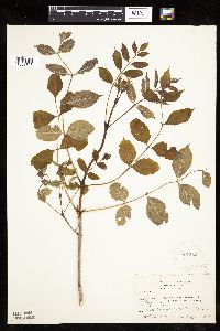 Fraxinus pennsylvanica Marshall 227382[1033895]Butters, F. 49421926-05-16 United States, Minnesota, Freeborn, NE of MacMillan's house, near Hollandale. Freeborn County;;;;, 43.76083 -93.20389 |
MIN:Plants | 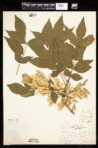 Fraxinus pennsylvanica Marshall 227393[1033872]Rosendahl, C.; Butters, F. 46851924-07-07 United States, Minnesota, Carlton, Jay Cooke Park;Jay Cooke State Park;048N;16W;, 46.6342494 -92.3645882 |
MIN:Plants | 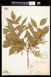 Fraxinus pennsylvanica Marshall 265412[1033909]Anonymous G2231912-00-00 United States, Minnesota, Rice, Northfield;;;;, 44.45833 -93.16139 |
MIN:Plants | 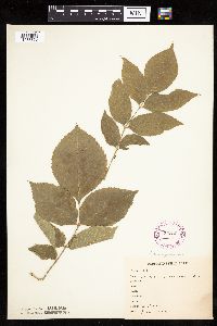 Fraxinus pennsylvanica Marshall 265462[1033850]Anonymous 1071917-07-00 United States, Minnesota, Kandiyohi, Willmar;;119N;35W;, 45.12194 -95.04306 |
MIN:Plants | 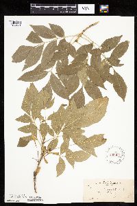 Fraxinus pennsylvanica Marshall 265909[1033921]Skinner, S. 1611902-06-19 United States, Minnesota, Jackson, Heron Lake region;;;;, 43.795 -95.32 |
MIN:Plants | 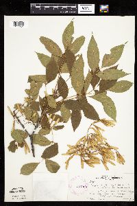 Fraxinus pennsylvanica Marshall 274924[1033934]Rosendahl, C. 57301928-08-15 United States, Minnesota, Fillmore, Along Upper Iowa River near Granger, Fillmore County;;101N;11W;, 43.54403 -92.14936 |
MIN:Plants | 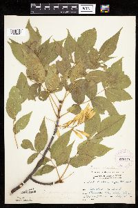 Fraxinus pennsylvanica Marshall 276163[1033849]Grant, Martin 30231929-08-06 United States, Minnesota, Clearwater, Itasca Park ... Clearwater County ... near State House ... SE1/4 NE1/4 Sec. 2 T143N R36W;Itasca State Park;143N;36W;2, 47.23197 -95.20153 |
MIN:Plants | 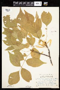 Fraxinus pennsylvanica Marshall 276164[1034062]Grant, Martin 33581929-09-17 United States, Minnesota, Clearwater, Itasca Park ... Clearwater County. Edge of Bohall Trail ... SE1/4 SW1/4 T143N, R36W.;Itasca State Park;143N;36W;9, 47.21713 -95.24447 |
MIN:Plants |  Fraxinus pennsylvanica Marshall 276903[1034051]Huff, N. 261914-07-02 United States, Minnesota, Lake, North Kawishiwi River, Lake Co.;Superior National Forest;;;, 47.90556 -91.71722 |
MIN:Plants |  Fraxinus pennsylvanica Marshall 281962[1033795]Rosendahl, C. 60851929-08-27 United States, Minnesota, Nobles, Okabena Lake, Worthington, Nobles Co.;;102N;40W;, 43.61611 -95.59917 |
MIN:Plants |  Fraxinus pennsylvanica Marshall 281963[1033942]Rosendahl, C. 60841929-08-27 United States, Minnesota, Nobles, Nobles County ... Okabena Lake, Worthington;;102N;40W;, 43.63116 -95.63376 |
MIN:Plants |  Fraxinus pennsylvanica Marshall 282856[1033874]Butters, F.; Buell, Murray 3721932-07-09 United States, Minnesota, Cook, Lake shore, W end of Gunflint Lake, Cook County;Superior National Forest;065N;03W;00, 48.1 -90.7 |
MIN:Plants | 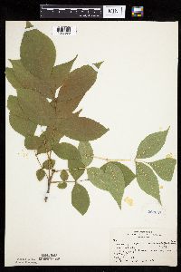 Fraxinus pennsylvanica Marshall 282857[1033985]Butters, F.; Buell, Murray 3731932-07-09 United States, Minnesota, Cook, W end of Gunflint Lake, Cook County;Superior National Forest;065N;03W;00, 48.08113 -90.70486 |
MIN:Plants | 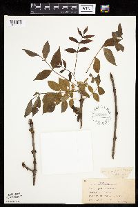 Fraxinus pennsylvanica Marshall 288575[1033835]Beach, W. 561914-04-30 United States, Minnesota, Ramsey, St. Anthony Park [St. Paul neighborhood near U of M];;029N;23W;, 44.9920769 -93.1663869 |
MIN:Plants | 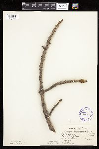 Fraxinus pennsylvanica Marshall 295480[1033794]McCartney, S. s.n.1935-05-01 United States, Minnesota, Rice, Rice Co. ... Between Northfield and Faribault;;;;, 44.37491 -93.21075 |
MIN:Plants | 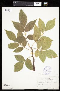 Fraxinus pennsylvanica Marshall 306913[1033881]Cottrell, R. s.n.1935-08-15 United States, Minnesota, Anoka, Anoka County ... Fridley;;030N;24W;, 45.08611 -93.26306 |
MIN:Plants |  Fraxinus pennsylvanica Marshall 332501[1033939]Grant, Martin 65861935-08-08 United States, Minnesota, Clearwater, Itasca Park ... Clearwater Co. ... SW1/4 NE1/4 Sec. 11 T143N R36W;Itasca State Park;143N;36W;11, 47.21752 -95.2015 |
MIN:Plants |  Fraxinus pennsylvanica Marshall 332615[1033873]Grant, Martin 67481935-09-03 United States, Minnesota, Clearwater, Itasca Park ... Clearwater Co. Squaw Lake ... NW1/4 SW1/4 Sec. 5 T143N R36W;Itasca State Park;143N;36W;5, 47.23143 -95.26579 |
MIN:Plants |  Fraxinus pennsylvanica Marshall 337704[1033971]Lakela, Olga 13751936-05-30 United States, Minnesota, Saint Louis, Minnesota Point. Front of cottage, bayside. SW of the old lighthouse ruins. Sec. 19, Duluth [other collections indicates this is in T49N R13W, Minnesota Point]. 049N 13W 19, 46.78333 -92.10639 |
MIN:Plants |  Fraxinus pennsylvanica Marshall 337705[1033920]Lakela, Olga 15741936-07-29 United States, Minnesota, Saint Louis, Bayside, Duluth; Sec. 19 [other collections indicates this is in T49N R13W, Minnesota Point];Minnesota Point;049N;13W;19, 46.72833 -92.04778 |
MIN:Plants | 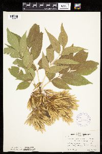 Fraxinus pennsylvanica Marshall 337811[1033842]Moyle, J. 23071936-08-09 United States, Minnesota, Lac Qui Parle, Lac Qui Parle Co. ... Island in Lac Qui Parle;Lac Qui Parle Wildlife Management Area;;;, 45.00056 -95.90583 |
MIN:Plants |  Fraxinus pennsylvanica Marshall 348185[1033858]Cook, E. 971938-06-27 United States, Minnesota, Ramsey, In front of Soils Building, University Farm, St. Paul;;029N;23W;, 44.9920769 -93.1663869 |
MIN:Plants |  Fraxinus pennsylvanica Marshall 349566[1033871]Rosendahl, C.; et al. 30581935-05-19 United States, Minnesota, Cottonwood, 8 mi S of Sanborn, Cottonwood Co.;;107N;36W;, 44.06476 -95.16012 |
MIN:Plants |  Fraxinus pennsylvanica Marshall 353080[1033815]Moyle, J.; et al. 28651934-08-15 United States, Minnesota, Yellow Medicine, Yellow Medicine Co. ... Minnesota River, 1 mi S of Granite Falls;;115N;39W;, 44.79552 -95.54528 |
MIN:Plants | 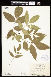 Fraxinus pennsylvanica Marshall 353410[1034050]Moyle, J. 4521931-06-30 United States, Minnesota, Clearwater, Itasca Park ... Clearwater Co. ... SE1/4 SE1/4 Sec. 2, T143N, R36W.;Itasca State Park;143N;36W;2, 47.23197 -95.20153 |
MIN:Plants | 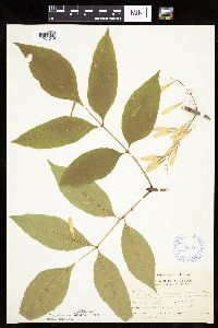 Fraxinus pennsylvanica Marshall 353417[1034019]Buell, Murray 3091932-06-30 United States, Minnesota, Clearwater, Itasca Park, Bear Point. Clearwater Co. ... SE1/4 NW1/4 Sec. 11, T143N, R36W;Itasca State Park;143N;36W;11, 47.217522 -95.201496 |
MIN:Plants | 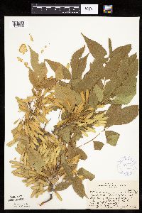 Fraxinus pennsylvanica Marshall 361781[1034059]Rosendahl, C.; Butters, F. 68691937-08-27 United States, Minnesota, Lake, Along old road, Big Stony River at second crossing from N. Lake Co.;Superior National Forest;060N;10W;27, 47.65429 -91.58664 |
MIN:Plants | 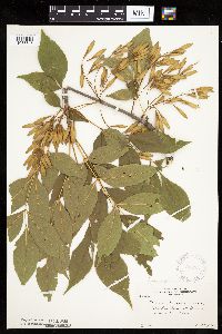 Fraxinus pennsylvanica Marshall 364397[1033843]Moyle, J. 28261937-08-11 United States, Minnesota, Winona, Winona Co. ... Island in Miss. at Winona;;;;, 44.05 -91.63917 |
MIN:Plants | 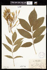 Fraxinus pennsylvanica Marshall 364896[1033861]Beach, W. 381913-07-12 United States, Minnesota, Ramsey, Everett Court, St. Paul;;;;, 44.9441 -93.0852 |
MIN:Plants | 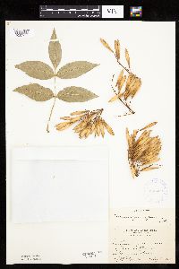 Fraxinus pennsylvanica Marshall 365200[1033797]Holzinger, John s.n.1900-09-00 United States, Minnesota, Winona, Winona;;;;, 44.05 -91.63917 |
MIN:Plants | 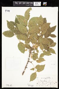 Fraxinus pennsylvanica Marshall 366092[1034048]Rosendahl, C.; et al. 73571939-09-14 United States, Minnesota, Yellow Medicine, Exposures of Schist in Minnesota Valley, 1 mi. S of Granite Falls. Yellow Medicine Co.;;115N;39W;, 44.79552 -95.54528 |
MIN:Plants | 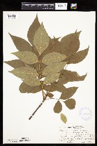 Fraxinus pennsylvanica Marshall 367219[1033986]Moore, John; Butters, F. 134911940-09-04 United States, Minnesota, Carlton, Carlton County ... 1/4 mi west of the state line, road E of Barker;;;;, 46.59941 -92.37595 |
MIN:Plants |  Fraxinus pennsylvanica Marshall 367225[1034035]Moore, John; Butters, F. 134851940-09-03 United States, Minnesota, Pine, South shore of Sturgeon Lake, Pine Co.;;045N;19W;, 46.37495 -92.7409 |
MIN:Plants |  Fraxinus pennsylvanica Marshall 368030[1033784]Moore, John; et al. 126881940-05-25 United States, Minnesota, Pope, Pope County ... North shore of Lake Leven; SW1/4 Sec. 12, Leven Twp.;;126N;37W;12, 45.73732 -95.27329 |
MIN:Plants |  Fraxinus pennsylvanica Marshall 368282[1034026]Moore, John; et al. 127451940-05-25 United States, Minnesota, Douglas, Douglas County ... 1/2 mile east of Brandon;;129N;39W;, 45.97685 -95.58271 |
MIN:Plants |  Fraxinus pennsylvanica Marshall 369389[1033972]Moore, John; et al. 142051941-06-13 United States, Minnesota, Clay, Clay County ... Beside Hwy. 75, 3-1/2 mile north of Moorhead;;140N;48W;, 46.93678 -96.72884 |
MIN:Plants |  Fraxinus pennsylvanica Marshall 369815[1033884]Moore, John; et al. 145381941-06-15 United States, Minnesota, Red Lake, Red Lake County ... Clearwater River; 1/2 mi. north of Plummer, on Hwy. 59;;151N;42W;, 47.89116 -96.03176 |
MIN:Plants |  Fraxinus pennsylvanica Marshall 370034[1033772]Moore, John; et al. 140301941-05-24 United States, Minnesota, Pine, Bordering the St. Croix River; NW1/4 Sec. 24 Rock Creek Twp. Pine Co.;Chengwatana State Forest;038N;20W;24, 45.76736 -92.78985 |
MIN:Plants |  Fraxinus pennsylvanica Marshall 370170[1034020]Moore, John; et al. 144371941-06-14 United States, Minnesota, Marshall, Marshall County ... Tamarack River, near Stephen;;157N;48W;, 48.41298 -96.8456 |
MIN:Plants |  Fraxinus pennsylvanica Marshall 370195[1033824]Moore, John; et al. 142291941-06-13 United States, Minnesota, Norman, Norman County ... Red River, 1 mi. W of Hendrum;;144N;49W;, 47.26444 -96.83244 |
MIN:Plants | 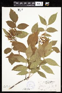 Fraxinus pennsylvanica Marshall 370289[1034022]Moore, John; et al. 145091941-06-15 United States, Minnesota, Pennington, Pennington County ... beside Hwy. 59 ... 3 mi. SE of Thief River Falls;;153N;43W;, 48.06412 -96.17623 |
MIN:Plants | 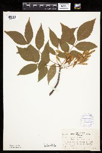 Fraxinus pennsylvanica Marshall 371161[1033839]Moore, John 131011940-06-20 United States, Minnesota, Yellow Medicine, Yellow Medicine County ... south side of Granite Falls;;115N;39W;, 44.81 -95.54528 |
MIN:Plants | 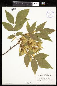 Fraxinus pennsylvanica Marshall 371550[1033808]Moore, John; et al. 149611941-08-07 United States, Minnesota, Kanabec, Kanabec County ... Along Snake River, 1/2 mi S of Mora;;039N;24W;, 45.84798 -93.29361 |
MIN:Plants | 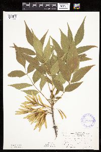 Fraxinus pennsylvanica Marshall 372546[1033806]Moore, John; et al. 147601941-07-07 United States, Minnesota, Otter Tail, East shore of West Lost Lake, 7.2 mi north of Underwood. Ottertail County;;134N;41W;, 46.38417 -95.87611 |
MIN:Plants | 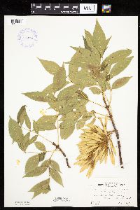 Fraxinus pennsylvanica Marshall 373904[1033825]Moore, John; et al. 150691941-08-09 United States, Minnesota, Beltrami, Beltrami County ... West shore of Lake Bemidji;;146N;33W;, 47.47194 -94.87611 |
MIN:Plants | 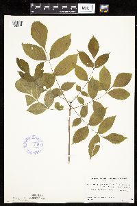 Fraxinus pennsylvanica Marshall 374025[1033780]Linnaean Club, U of M, 941939-05-21 United States, Minnesota, Rice, Nerstrand Woods, Rice Co. ... near N fence;Nerstrand Woods State Park;110N;19W;, 44.32706 -93.10089 |
MIN:Plants | 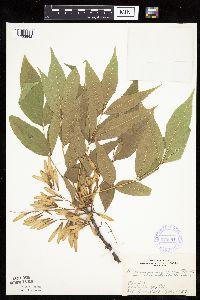 Fraxinus pennsylvanica Marshall 376064[1033992]Dahl, A. s.n.1937-07-01 United States, Minnesota, Renville, Renville County ... Fairfax;;112N;32W;, 44.49921 -94.68455 |
MIN:Plants | 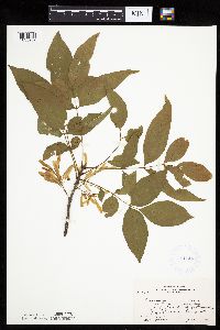 Fraxinus pennsylvanica Marshall 381144[1033989]Moore, John; Moore, Marjorie 152751942-06-11 United States, Minnesota, Isanti, Isanti County ... NW1/4 Sec. 32 Stanchfield Twp.;;037N;23W;32, 45.65161 -93.23425 |
MIN:Plants | 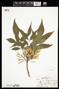 Fraxinus pennsylvanica Marshall 381445[1033990]Moore, John; et al. 154381942-06-20 United States, Minnesota, Dodge, Dodge County ... Hwy 57, Zumbro River, 1 mi NE of Berne ... Milton Twp.;;108N;16W;, 44.15236 -92.73871 |
MIN:Plants | 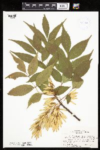 Fraxinus pennsylvanica Marshall 381501[1033991]Moore, John; et al. 154001942-06-20 United States, Minnesota, Olmsted, Olmsted County ... 1 mile northN of Rochester on hwy 63;;;;, 44.02167 -92.46972 |
MIN:Plants | 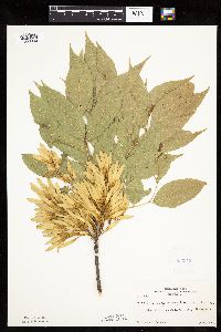 Fraxinus pennsylvanica Marshall 383543[1033830]Moore, John 158741943-06-30 United States, Minnesota, Dakota, Dakota County ... Chub Lake;;113N;20W;, 44.56528 -93.21667 |
MIN:Plants | 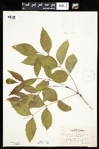 Fraxinus pennsylvanica Marshall 405346[1033902]Lakela, Olga 81931949-06-04 United States, Minnesota, Saint Louis, Shore of Prairie Lake. St. Louis Co.;;050N;20W;, 46.80928 -92.87068 |
MIN:Plants | 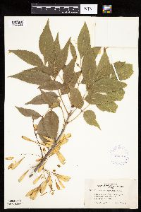 Fraxinus pennsylvanica Marshall 407084[1034034]Lakela, Olga 95181949-08-28 United States, Minnesota, Saint Louis, Shore of Lake Kabetogama near Park Point Resort. St. Louis Co.;Voyageurs National Park;;;, 48.48028 -93.055 |
MIN:Plants | 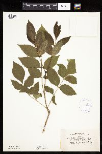 Fraxinus pennsylvanica Marshall 407206[1033903]Lakela, Olga 85931949-06-26 United States, Minnesota, Saint Louis, St. Louis County ... White Iron Lake, E of Ely;;062N;12W;, 47.84605 -91.86099 |
MIN:Plants | 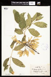 Fraxinus pennsylvanica Marshall 407241[1033907]Lakela, Olga 93241949-08-13 United States, Minnesota, Saint Louis, Prairie Lake. St. Louis Co.;;050N;20W;, 46.80928 -92.87068 |
MIN:Plants | 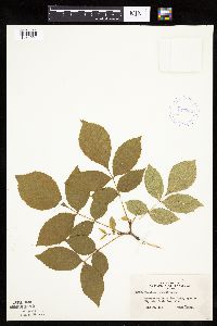 Fraxinus pennsylvanica Marshall 407289[1034001]Lakela, Olga 85831949-06-26 United States, Minnesota, Saint Louis, Terrace of White Iron Lake, E of Ely. St. Louis Co.;Superior National Forest;062N;12W;, 47.84605 -91.86099 |
MIN:Plants | 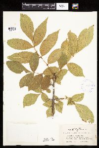 Fraxinus pennsylvanica Marshall 407375[1033792]Lakela, Olga 95191949-08-28 United States, Minnesota, Saint Louis, Lake Kabetogama near Park Point Resort. St. Louis Co.;Voyageurs National Park;;;, 48.48028 -93.055 |
MIN:Plants | 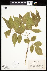 Fraxinus pennsylvanica Marshall 407586[1034002]Lakela, Olga 81921949-06-04 United States, Minnesota, Saint Louis, Prairie Lake, SW St. Louis Co.;;050N;20W;, 46.80928 -92.87068 |
MIN:Plants | 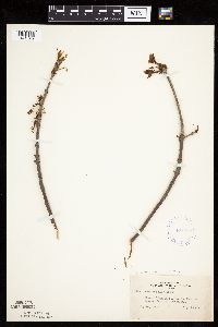 Fraxinus pennsylvanica Marshall 407635[1033769]Lakela, Olga 79831949-05-14 United States, Minnesota, Lake, Basswood Lake, The Hubachek Estate. Lake Co. [this was on Back Bay];Boundary Waters Canoe Area Wilderness / Superior National Forest;064N;10W;00, 48.075 -91.575 |
MIN:Plants | 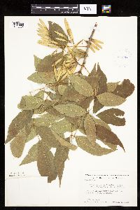 Fraxinus pennsylvanica Marshall 412564[1033823]Moore, John; Moore, Marjorie 114241939-08-03 United States, Minnesota, Roseau, Roseau County ... On the S side of the Warroad River, Warroad;;163N;36W;, 48.90528 -95.31417 |
MIN:Plants | 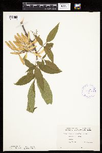 Fraxinus pennsylvanica Marshall 416686[1034023]Lakela, Olga 85861949-06-26 United States, Minnesota, Saint Louis, Fall River, Winton. St. Louis Co.;Superior National Forest;063N;12W;, 47.93309 -91.86107 |
MIN:Plants |  Fraxinus pennsylvanica Marshall 419146[1033817]Ahlgren, Clifford 4741949-07-23 United States, Minnesota, Lake, Quetico-Superior Wilderness Research Center...Lake County ... Sec. 9 T64N R10W;Boundary Waters Canoe Area Wilderness / Superior National Forest;064N;10W;09, 48.03165 -91.61886 |
MIN:Plants |  Fraxinus pennsylvanica Marshall 420128[1033924]Lakela, Olga 117751950-08-25 United States, Minnesota, Saint Louis, St. Louis County ... Iron Lake, south of Crooked Lake;Boundary Waters Canoe Area Wilderness / Superior National Forest;066N;13W;00, 48.1945 -91.99516 |
MIN:Plants |  Fraxinus pennsylvanica Marshall 420891[1033925]Lakela, Olga 118081950-08-26 United States, Minnesota, Saint Louis, St. Louis County ... Lac La Croix, 8 miles west of Curtain Falls;Boundary Waters Canoe Area Wilderness / Superior National Forest;067N;13W;, 48.27662 -92.02661 |
MIN:Plants | 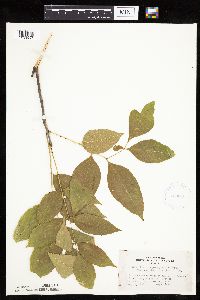 Fraxinus pennsylvanica Marshall 420965[1033997]Lakela, Olga 111821950-08-08 United States, Minnesota, Saint Louis, St. Louis County ... At the end of Savanna River Road, hwy 29, W of Floodwood;;051N;21W;, 46.89651 -92.99534 |
MIN:Plants | 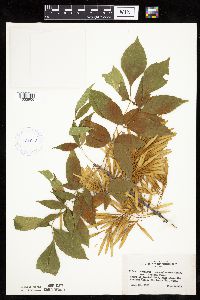 Fraxinus pennsylvanica Marshall 421043[1033906]Lakela, Olga 115431950-08-21 United States, Minnesota, Saint Louis, St. Louis County ... Crooked Lake, just above the Curtain Falls;Boundary Waters Canoe Area Wilderness / Superior National Forest;066N;12W;, 48.18679 -91.86997 |
MIN:Plants | 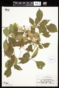 Fraxinus pennsylvanica Marshall 421085[1033998]Lakela, Olga 115441950-08-21 United States, Minnesota, Saint Louis, St. Louis County ... Crooked Lake, near Curtain Falls;Boundary Waters Canoe Area Wilderness / Superior National Forest;066N;12W;, 48.18679 -91.86997 |
MIN:Plants | 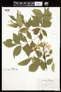 Fraxinus pennsylvanica Marshall 421142[1034042]Lakela, Olga 114031950-08-14 United States, Minnesota, Saint Louis, St. Louis County ... Park grounds at Fond du Lac;;048N;15W;, 46.65701 -92.25726 |
MIN:Plants | 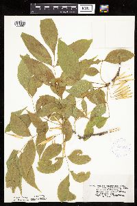 Fraxinus pennsylvanica Marshall 421263[1033987]Lakela, Olga 120901950-09-06 United States, Minnesota, Saint Louis, St. Louis County ... Side Lake, at Sturgeon Lake, N of Hibbing;Sturgeon River State Forest;060N;21W;, 47.67592 -92.9968 |
MIN:Plants | 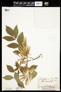 Fraxinus pennsylvanica Marshall 421665[1034025]Ahlgren, Clifford 11281950-08-22 United States, Minnesota, Saint Louis, St. Louis County ... Collected at Curtain Falls, Crooked Lake;Boundary Waters Canoe Area Wilderness / Superior National Forest;066N;12W;, 48.18679 -91.86997 |
MIN:Plants | 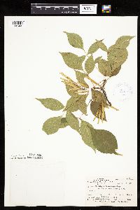 Fraxinus pennsylvanica Marshall 421666[1034005]Ahlgren, Clifford 11241950-08-22 United States, Minnesota, Saint Louis, St. Louis County ... Collected along portage trail 1/8 mi W of Curtain Falls, Crooked Lake;Boundary Waters Canoe Area Wilderness / Superior National Forest;066N;12W;, 48.18679 -91.86997 |
MIN:Plants | 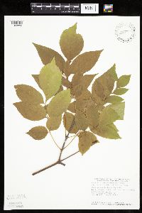 Fraxinus pennsylvanica Marshall 439409[1033856]Smith, Welby 164031989-09-06 United States, Minnesota, Benton, Benton County ... On the east bank of the Mississippi River in Rice ... NE1/4 NE1/4 sec.36, T38N R32W;;038N;32W;36, 45.748333 -94.2600021 |
MIN:Plants | 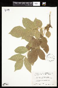 Fraxinus pennsylvanica Marshall 442236[1033904]Moore, John; Huff, N. 190901946-08-17 United States, Minnesota, Swift, in city park at Benson, Swift County;;121N;39W;, 45.28178 -95.56232 |
MIN:Plants | 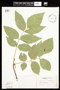 Fraxinus pennsylvanica Marshall 442385[1034056]Lakela, Olga 134021951-07-11 United States, Minnesota, Saint Louis, St. Louis County ... Rainy Lake, at Kettle Falls;Voyageurs National Park;070N;18W;, 48.49944 -92.63889 |
MIN:Plants | 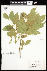 Fraxinus pennsylvanica Marshall 442456[1033910]Lakela, Olga 132311951-06-14 United States, Minnesota, Saint Louis, St. Louis County ... Rainy Lake at Kettle Falls;Voyageurs National Park;070N;18W;, 48.52144 -92.66536 |
Google Map
Google Maps is a web mapping service provided by Google that features a map that users can pan (by dragging the mouse) and zoom (by using the mouse wheel). Collection points are displayed as colored markers that when clicked on, displays the full information for that collection. When multiple species are queried (separated by semi-colons), different colored markers denote each individual species.