University of Minnesota
http://www.umn.edu/
612-625-5000
http://www.umn.edu/
612-625-5000
Minnesota Biodiversity Atlas
Bell Museum
Dataset: MIN-Plants
Taxa: Oleaceae
Search Criteria: excluding cultivated/captive occurrences
Bell Museum plants | |
 MIN:Plants | 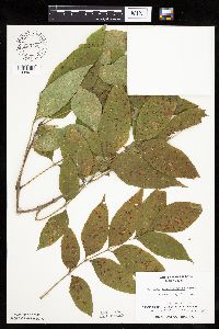 Fraxinus pennsylvanica Marshall 753172[1034011]Boe, J. 20821983-08-27 United States, Minnesota, Kittson, Kittson County ... Norway Dunes: NW1/4 SE1/4 Sec. 10. T160N, R46W.;Norway Dunes, The Nature Conservancy;160N;46W;10, 48.69574 -96.57277 |
MIN:Plants | 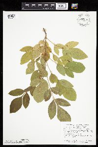 Fraxinus pennsylvanica Marshall 759165[1033946]Smith, Welby 69301982-07-28 United States, Minnesota, Mower, Racine Prairie Scientific Natural Area. Mower County ... Racine Prairie State Scientific and Natural Area, adjacent to the east side of U.S. Trunk Highway 63, about 2 miles north of Racine ... NE1/4 NE1/4 Sec. 22 T104N R14W. 104N 14W 22, 43.79764 -92.49927 |
MIN:Plants | 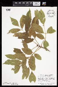 Fraxinus pennsylvanica Marshall 770275[1033944]Smith, Welby 83461983-07-25 United States, Minnesota, Wabasha, Kellogg-Weaver Dunes Scientific Natural Area / Kellogg-Weaver Dunes, The Nature Conservancy. Wabasha County ... Kellogg-Weaver Dunes State Scientific and Natural Area, about 4 miles southeast of Kellogg, on the east side of county road 84; NW1/4 NE1/4 Sec. 6 T109N R9W. 109N 09W 6, 44.27261 -91.93898 |
MIN:Plants | 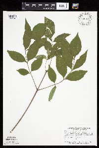 Fraxinus pennsylvanica Marshall 770530[1033943]Smith, Welby 85531983-08-03 United States, Minnesota, Mower, Mower County ... About 3 miles northeast of Lyle ... NW1/4 NE1/4 Sec. 29 T101N R17W;;101N;17W;29, 43.5215 -92.89853 |
MIN:Plants |  Fraxinus pennsylvanica Marshall 773356[1034013]Boe, J. 11921979-08-01 United States, Minnesota, Lake of the Woods, Lake of the Woods County ... Morris Point sandbar. T162N, R32W, Sec. 16. Near resort.;;162N;32W;16, 48.85164 -94.7733 |
MIN:Plants |  Fraxinus pennsylvanica Marshall 773508[1034012]Boe, J. 15681979-08-18 United States, Minnesota, Lake of the Woods, Lake of the Woods County ... Northwest Angle. Near Stony Point. Sec. 35, R35W, T166N.;Northwest Angle;166N;35W;35, 49.15707 -95.12582 |
MIN:Plants |  Fraxinus pennsylvanica Marshall 774177[1033966]Monson, Paul 53201983-06-16 United States, Minnesota, Saint Louis, Kabetogama Peninsula E of Camel Back Island;Voyageurs National Park;070N;21W;34, 48.50713 -93.01521 |
MIN:Plants |  Fraxinus pennsylvanica Marshall 781257[1033801]Smith, Welby 93061984-06-23 United States, Minnesota, Mower, Lake Louise State Park. Mower County ... Lake Louise State Park, about 1 mile north-northwest of Le Roy, on the banks of the Upper Iowa River ... NW1/4 NE1/4 Sec. 28 T101N R14W. 101N 14W 28, 43.5221 -92.51896 |
MIN:Plants |  Fraxinus pennsylvanica Marshall 789654[1033857]Smith, Welby 101921985-05-28 United States, Minnesota, Jackson, Kilen Woods State Park. Jackson County ... Kilen Woods State Park, about 8 mi north-northwest of Jackson, in the Des Moines River Valley; SW1/4 NE1/4 Sec. 17 T103N R35W. 103N 35W 17, 43.72481 -95.06465 |
MIN:Plants |  Fraxinus pennsylvanica Marshall 795904[1034058]Smith, Welby 120831986-07-08 United States, Minnesota, Mower, Brandt-Larson Wildlife Management Area. Mower County ... Brandt-Larson State Wildlife Management Area, about 4 miles northeast of Lyle. Along Otter Creek. NE1/4 SW1/4 Sec. 16, T101N, R17W. 101N 17W 16, 43.5469437 -92.8813858 |
MIN:Plants |  Fraxinus pennsylvanica Marshall 814761[1033845]Wheeler, Gerald 109451988-06-26 United States, Minnesota, Traverse, Traverse County ... Ca. 3 mi. SW of Wheaton ...E of Rte. 27, near the airport ... bordering the Mustinka River (S bank). N1/2 N1/2 Sec. 26, T127N, R47W (Lake Twp.). 127N 47W 26, 45.78135 -96.54189 |
MIN:Plants |  Fraxinus pennsylvanica Marshall 817414[1283378]Delaney, B. 890241989-06-15 United States, Minnesota, Isanti, N border of county, SW1/4 SW1/4 of section;Cranberry Wildlife Management Area;037N;24W;4, 45.7236841 -93.3379822 |
MIN:Plants |  Fraxinus pennsylvanica Marshall 824332[1034053]Marion, J. s.n.1982-00-00 United States, Minnesota, Cook, Cook Co, North Shore of Lake Superior, ca. 200 ft. from lakeshore.;North Shore;;;, 47.46396 -91.02551 |
MIN:Plants |  Fraxinus pennsylvanica Marshall 841046[1033826]Smith, Welby 127641987-05-25 United States, Minnesota, Steele, Aurora Wildlife Management Area. Steele County ... Aurora State Wildlife Management Area, about 8 mi NW of Blooming Prairie; SE1/4 NW1/4 sec.20 T106N R19W. 106N 19W 20, 43.9736099 -93.1397247 |
MIN:Plants |  Fraxinus pennsylvanica Marshall 841673[1283377]Smith, Welby 133081987-07-07 United States, Minnesota, Washington, Island in the St. Croix River, about 2 mi NE of Scandia ... SE1/4 SE1/4 of sec.;;032N;19W;7, 45.2675018 -92.7555542 |
MIN:Plants |  Fraxinus pennsylvanica Marshall 171651[1034093]Moyer, Lycurgus 28391894-07-00 United States, Minnesota, Chippewa, Montevideo;;117N;40W;, 44.93463 -95.67577 |
MIN:Plants | Fraxinus pennsylvanica Marshall 511632[]US Nat. Arboretum staff 1301975-00-00 United States, District of Columbia, Washington |
MIN:Plants |  Fraxinus pennsylvanica Marshall 918259[1034018]Smith, Welby; et al. 314562009-09-10 United States, Minnesota, Cook, Boundary Waters Canoe Area Wilderness / Superior National Forest. Cook County...Boundary Waters Canoe Area Wilderness, Superior National Forest. At the east end of John Lake, on the north side...T 65N R 3E SE1/4 of SW1/4 of Sec 34. 065N 03E 34, 48.0672222 -90.0505556 |
MIN:Plants | Fraxinus pennsylvanica Marshall 506885[]US Nat. Arboretum staff 1311975-00-00 United States, District of Columbia, Washington |
MIN:Plants |  Fraxinus pennsylvanica Marshall 897192[1033956]Smith, Welby 273001998-06-29 United States, Minnesota, Itasca, Itasca County...Along the Big Fork River, just east of the town of Bigfork...T 61N R 26W NE1/4 of SW1/4 of Sec 27;;061N;26W;27, 47.7467811 -93.6514016 |
MIN:Plants |  Fraxinus pennsylvanica Marshall 453691[1034030]Smith, Welby 286492000-06-27 United States, Minnesota, Washington, Washington County ... In Afton State Park, in the St. Croix River Valley ... T28N R20W SE1/4 of SW1/4 of Sec 35;Afton State Park;028N;20W;35, 44.8652763 -92.7727814 |
MIN:Plants |  Fraxinus pennsylvanica Marshall 899547[1034029]Smith, Welby 273411998-07-09 United States, Minnesota, Mahnomen, Mahnomen County...On the north side of McCraney Lake, about 12 mi east of Waubun...T143N R40W SE1/4 of NW1/4 of Sec 25;White Earth Indian Reservation / White Earth State Forest;143N;40W;25, 47.1722222 -95.6933333 |
MIN:Plants |  Fraxinus pennsylvanica Marshall 462420[1034008]Smith, Welby 165621990-05-15 United States, Minnesota, Faribault, Pihls County Park. Faribault County...In Pihls County Park, on the west side of Rice Lake, about 6 miles south of Wells...T 102N R 24W SW1/4 of NW1/4 of Sec 16. 102N 24W 16, 43.6402779 -93.7272186 |
MIN:Plants |  Fraxinus pennsylvanica Marshall 436847[1033955]Gerdes, Lynden 48932004-08-05 United States, Minnesota, Lake, Superior National Forest. T60N R08W S04NENWS Lake County ... Superior National Forest. Approximately 6.34 miles N of Isabella, MN. 1.66 mile SW of Helen Lake and 0.11 mile E of the Northwest Road (FR 373).. 060N 08W 4, 47.70912 -91.35242 |
MIN:Plants |  Fraxinus pennsylvanica Marshall 429243[1033993]Smith, Welby 272751998-06-25 United States, Minnesota, Anoka, Rum River County Park. Anoka County ... Rum River North County Park, about 7 miles NW of East Bethel ... T 134N [should be T34N] R 24W NW1/4 of NE1/4 of Sec 32. 034N 24W 32, 45.3902779 -93.3550034 |
MIN:Plants |  Fraxinus pennsylvanica Marshall 462293[1033755]Smith, Welby 292672002-05-16 United States, Minnesota, Ramsey, Snail Lake Vadnais Lake County Park. Ramsey County ... In Snail Lake Regional Park; on the east side of Grass Lake in Shoreview ... T30N R23W NE1/4 of SE1/4 of Sec 25. 030N 23W 25, 45.0555573 -93.1102753 |
MIN:Plants |  Fraxinus pennsylvanica Marshall 455367[1033804]Lee, Michael MDL15891996-09-19 United States, Minnesota, Kandiyohi, Sibley State Park. Kandiyohi County ... Sibley State Park. Seven miles WNW of New London ... between Swan & Middle Lakes ... T121N R35W SW1/4 NE1/4 Sec. 4. 121N 35W 4, 45.3185 -95.08107 |
MIN:Plants | 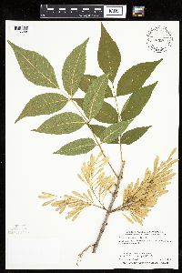 Fraxinus pennsylvanica Marshall 429242[1033994]Smith, Welby 285942000-06-17 United States, Minnesota, Otter Tail, Otter Tail County ... About 3 miles N-NE of Pelican Rapids ... T 136N R 43W SW1/4 of NW1/4 of sec 12;;136N;43W;12, 46.607959 -96.042261 |
MIN:Plants | 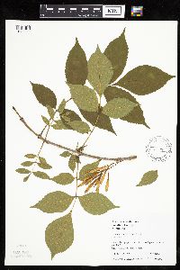 Fraxinus pennsylvanica Marshall 491146[1033995]Juhnke, C. 359 CMJ FRO1999-06-11 United States, Minnesota, Goodhue, Frontenac State Park Goodhue County ... Just south of overlook/picnic grounds parking lot ... T112N R13W NW NW SE 2;Frontenac State Park;112N;13W;02, 44.53507 -92.33916 |
MIN:Plants | 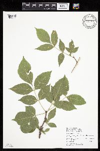 Fraxinus pennsylvanica Marshall 914986[1033866]Walton, G. 31151998-06-20 United States, Minnesota, Cook, Cook County...Superior National Forest Tofte District...T62N, R1E, SW1/4 of SE1/4 of Sec. 11, Grand Marais;Superior National Forest;062N;01E;11, 47.86779 -90.2865 |
MIN:Plants | 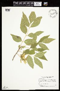 Fraxinus pennsylvanica Marshall 435634[1033787]Boe, J. 970724011997-07-24 United States, Minnesota, Aitkin, Aitkin County ... On Battle Island in Big Sandy Lake. In releve 97-19 ... T 49N R 23W NW1/4 of SW1/4 of Sec 4;Savanna State Forest;049N;23W;4, 46.76061 -93.26517 |
MIN:Plants | 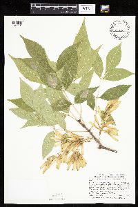 Fraxinus pennsylvanica Marshall 454324[1033913]Smith, Welby 290242000-08-23 United States, Minnesota, Le Sueur, Le Sueur County ... Sakatah Lake State Park; about 2 miles east of Waterville ... T 109N R 23 NW1/4 of NE1/4 of Sec 25;Sakatah Lake State Park;109N;23W;25, 44.2241669 -93.5294418 |
MIN:Plants | 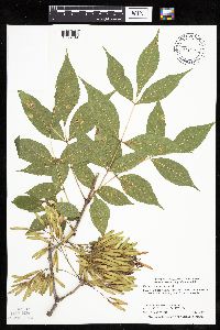 Fraxinus pennsylvanica Marshall 428975[1033789]Smith, Welby 279941999-07-15 United States, Minnesota, Rock, Rock River Wildlife Management Area. Rock County ... Rock River State Wildlife Management Area, about 2 miles NE of Luverne ... T 102N R 45W NE1/4 of NE1/4 of Sec 1. 102N 45W 1, 43.6713905 -96.1736145 |
MIN:Plants | 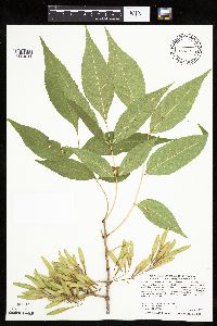 Fraxinus pennsylvanica Marshall 511012[1034044]Smith, Welby 288722000-08-01 United States, Minnesota, Carlton, Carlton County ... Along the Willard Munger State Trail, about 1/4 mile east of Carlton (town) ... T 48N R 16W NW1/4 of NE1/4 of Sec 7. 048N 16W 7, 46.6622222 -92.4161111 |
MIN:Plants | 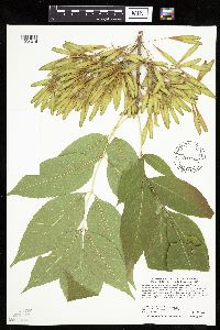 Fraxinus pennsylvanica Marshall 429234[1034016]Smith, Welby 288562000-07-28 United States, Minnesota, Houston, Houston County ... On the Mississippi River bottoms near Reno ... T 101N R 4W SE1/4 of NE1/4 of sec 23;Upper Mississippi National Wildlife Refuge;101N;04W;23, 43.5391655 -91.2755585 |
MIN:Plants |  Fraxinus pennsylvanica Marshall 444561[1033840]Abbott, Robinson s.n.1961-07-25 United States, Minnesota, Stevens, Stevens County...edge of S. Pomme de Terre Lake off rt. 59. N. of Morris;;126N;41W;00, 45.71613 -95.82023 |
MIN:Plants |  Fraxinus pennsylvanica Marshall 429127[1034028]Smith, Welby 288982000-08-04 United States, Minnesota, Ramsey, Ramsey County ... Near the public access at the south end of Otter Lake ... T30N R22W SW1/4 of NW1/4 of Sec 3;;030N;22W;03, 45.1180573 -93.042778 |
MIN:Plants |  Fraxinus pennsylvanica Marshall 454886[1034032]Smith, Welby 251451994-08-17 United States, Minnesota, Koochiching, Along the Rainy River, about 12 miles west of Loman. NW/4 of SE1/4 of section;;160N;26W;36, 48.6302778 -93.9122222 |
MIN:Plants |  Fraxinus pennsylvanica Marshall 511740[1034045]Smith, Welby 286562000-07-05 United States, Minnesota, Anoka, Lamprey Pass Wildlife Management Area. Anoka County ... Lamprey Pass State Wildlfie Management Area, about 2 miles SW of Forest Lake (town) ... T 32N R 22W SW1/4 of NE1/4 of Sec 13. 032N 22W 13, 45.2619444 -93.0294444 |
MIN:Plants |  Fraxinus pennsylvanica Marshall 913751[1033834]Smith, Welby 227691993-07-09 United States, Minnesota, Rock, Rock County...About 0.5 mile southeast of Luverne...along the Rock River...T102N R45W NE1/4 of SE1/4 of sec 11;;102N;45W;11, 43.6505556 -96.1961111 |
MIN:Plants |  Fraxinus pennsylvanica Marshall 479292[1033788]Moore, John 631971-06-09 United States, Minnesota, Sherburne, SE1/4 Sec. 36 Santiago [Twp.];;035N;28W;36, 45.53917 -93.81972 |
MIN:Plants |  Fraxinus pennsylvanica Marshall 482129[1034064]Gerdes, Lynden; et al. 31161998-08-10 United States, Minnesota, Cook, T65N R02W S19NESE. Cook County; Superior National Forest. Shore area of bay in far southeast end of Gunflint Lake.;Superior National Forest;065N;02W;19, 48.09871 -90.63042 |
MIN:Plants |  Fraxinus pennsylvanica Marshall 896848[1033984]Haferman, J. 1971996-05-23 United States, Minnesota, Scott, Approx. 0.1 miles NNE of intersection of State Highway 13 and County Road 44 on N side of highway. SW1/4 of SW1/4 of section.;;115N;22W;36, 44.72459 -93.40903 |
MIN:Plants | 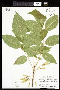 Fraxinus pennsylvanica Marshall 540833[1034033]Smith, Welby 287192000-07-12 United States, Minnesota, Mille Lacs, About 8 miles northwest of Onamia. SW1/4 of SE1/4 of section;Mille Lacs Kathio State Park;042N;27W;05, 46.1286111 -93.7725 |
MIN:Plants | 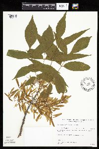 Fraxinus pennsylvanica Marshall 489485[1033996]Gerdes, Lynden; et al. 34921999-06-23 United States, Minnesota, Cook, T65N R02W S19SENE Cook County...Superior National Forest. Northeast corner of the most southeastern bay of Gunflint Lake;Superior National Forest;065N;02W;19, 48.09871 -90.63042 |
MIN:Plants | 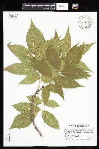 Fraxinus pennsylvanica Marshall 918248[1033933]Smith, Welby 224371993-06-18 United States, Minnesota, Grant, Grant County ... On the south side of Ask Lake, about 1.5 miles east-southeast of Ashby ...T130N R41W NW1/4 of SW1/4 of Sec 12. 130N 41W 12, 46.0847222 -95.7886111 |
MIN:Plants | 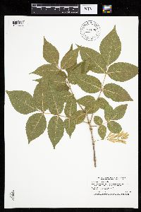 Fraxinus pennsylvanica Marshall 904595[1033775]Smith, Welby 26176A1996-06-19 United States, Minnesota, Douglas, Douglas County ... Lake Carlos State Park, about 6.5 miles north of Alexandria ... T129N R37W NE1/4 of NW1/4 of Sec 9;Lake Carlos State Park;129N;37W;09, 46.0022222 -95.3466667 |
MIN:Plants | 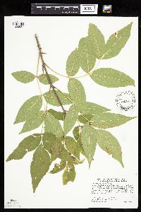 Fraxinus pennsylvanica Marshall 453700[1033981]Smith, Welby 286552000-07-05 United States, Minnesota, Anoka, Lamprey Pass Wildlife Management Area. Anoka County ... Lamprey Pass State Wildlife Management Area, about 2 miles SW of Forest lake ... T32N R22W SW1/4 of NE1/4 of Sec 13. 032N 22W 13, 45.2619438 -93.0294418 |
MIN:Plants | 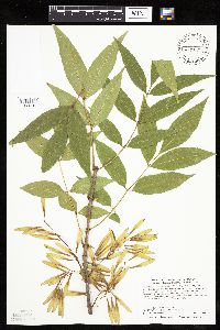 Fraxinus pennsylvanica Marshall 429315[1033796]Smith, Welby 288552000-07-28 United States, Minnesota, Houston, Dorer Memorial Hardwood State Forest. Houston County ... Reno State Recreation Area, about 1 mile N-NW of the town of Reno ... T 102N R 4W SE1/4 of NW1/4 of Sec 26. 102N 04W 26, 43.6091652 -91.2861099 |
MIN:Plants | 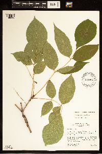 Fraxinus pennsylvanica Marshall 921882[1283380]Widrlechner, M.; Humenberger, Egon 6792010-08-18 United States, Minnesota, Chisago, East side of Co. 16 about 100 meters north of entrance to Lions Park (North Unit);;034N;18W;18, 45.43167 -92.6517, 242m |
MIN:Plants | 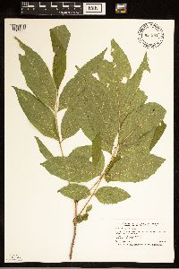 Fraxinus pennsylvanica Marshall 921294[1283387]Smith, Welby 249781994-07-27 United States, Minnesota, Crow Wing, Crow Wing State Park. Crow Wing State Park, about 4 miles southwest of Barrows (town). On the bank of the Crow Wing River...T 44N R 32W NW1/4 of SE1/4 of Sec 23. 044N 32W 23, 46.2772222 -94.3391667 |
MIN:Plants |  Fraxinus pennsylvanica Marshall 921090[1283390]Smith, Welby 248141994-07-14 United States, Minnesota, Koochiching, At the Sturgeon River Landing, on the south bank of the Sturgeon river about 4 miles west-northwest of Big Falls. SW1/4 of SW1/4 of section;Pine Island State Forest;155N;25W;29, 48.2116667 -93.8836111 |
MIN:Plants |  Fraxinus pennsylvanica Marshall 921927[1283389]Smith, Welby 234921993-08-10 United States, Minnesota, Murray, Lake Shetek State Park, about 3 miles northwest of Currie...T 107N R 40W NW1/4 of NW1/4 of Sec 6;Lake Shetek State Park;107N;40W;06, 44.1061111 -95.7005556 |
MIN:Plants |  Fraxinus pennsylvanica Marshall 923070[1283388]Smith, Welby 238431993-09-03 United States, Minnesota, Scott, (Lawrence Unit), about 4 miles west-southwest of Jordan. SW1/4 of NE1/4 of section;Minnesota Valley State Park;114N;24W;28, 44.6541667 -93.7119444 |
MIN:Plants |  Fraxinus pennsylvanica Marshall 933507[1283383]Smith, Welby R. 205221992-06-24 United States, Minnesota, Brown, On the south side of New Ulm in the Cottonwood River Valley NW of SE of section;Flandrau State Park;110N;30W;32, 44.2875 -94.4608333 |
MIN:Plants |  Fraxinus pennsylvanica Marshall 934931[1283382]Whitfeld, T. J. S.; et al. 7572011-09-06 United States, Minnesota, Chisago, UTM: 15T0519840, 5042913;Wild River State Park;;;, 45.53947 -92.7458761 |
MIN:Plants |  Fraxinus pennsylvanica Marshall 939702[1283379]Smith, Welby R. 321952010-09-03 United States, Minnesota, Saint Louis, Along the Whiteface River about 6 miles east of Cotton. NE of NE of section;;054N;16W;10, 47.1808761 -92.348627 |
MIN:Plants |  Fraxinus pennsylvanica Marshall 937664[1283381]Gerdes, Lynden B.; Gerdes, D. Lawson 66232012-07-13 United States, Minnesota, Lake, Bald Eagle Lake. Approximately 16.33 miles NW of Isabella, MN along the eastern shoreline.;Boundary Waters Canoe Area Wilderness / Superior National Forest;062N;09W;30, 47.819722 -91.531667 |
MIN:Plants |  Fraxinus pennsylvanica Marshall 953241[1291745]Bourdaghs, Michael s.n.2016-08-16 United States, Minnesota, Pope, Approx. 4 miles southeast of Villard, MPCA wetland monitoring site 11POPE118, 45.674549 -95.210545 |
MIN:Plants |  Fraxinus pennsylvanica Marshall 963077[1346781]Whitfeld, T.J.S. 22332019-06-22 United States, Minnesota, Cass, Us Army Corps of Engineers Winnibigoshish Recreation Area, dam, 47.427283 -94.055106 |
MIN:Plants |  Fraxinus pennsylvanica Marshall 964132[1375101]Marsh, Lucian s.n. United States, Minnesota, Cass |
MIN:Plants |  Fraxinus pennsylvanica Marshall 964141[1375110] United States, Iowa |
MIN:Plants |  Fraxinus pennsylvanica Marshall 967624[1368179]Drew, L.A. s.n.1969-07-19 United States, Minnesota, Rock, Blue Mounds State Park; T103N R45W sec. 24 NE NW 1/4; 43.715593 -96.185194, 43.715593 -96.185194 |
MIN:Plants |  Fraxinus pennsylvanica Marshall 971261[1394738]M. H. Nee 659022020-07-05 United States, Wisconsin, Crawford, Fishing area on Wisconsin River below Hwy. 60/61, just S of junction with Hwy. 60. T 8 N; R 3 W; SW¼ SW¼ sect. 14., 43.165556 -90.704167, 200m |
MIN:Plants |  Fraxinus pennsylvanica Marshall 971238[1394715]M. H. Nee 665262020-09-16 United States, Wisconsin, Pepin, 1.8 km SE of Stockholm, between Hwy. 35 and the railroad, SE of junction with Hwy. JJ. T 23 N; R 15 W; NW¼SE¼ sect. 18., 44.474167 -92.243056, 210m |
MIN:Plants | Fraxinus pennsylvanica Marshall []Gernes, Mark 2022-06-14 United States, Minnesota, Kandiyohi, Sibley State Park; Site ID: 21KAND264; Visit Number: 2632, 45.3265027 -95.04142475 |
MIN:Plants |  Fraxinus pennsylvanica Marshall 973022[1398575]Lee, Michael MDL60402012-07-22 United States, Minnesota, Lake, Boundary Waters Canoe Area Wilderness; Rolling bedrock terrain east of Wind Bay, Basswood Lake, 16 miles northeast of Ely; in a large bay southeast of Lincoln Island., 48.0354472423 -91.5615392437, 398m |
MIN:Plants |  Fraxinus pennsylvanica Marshall 974493[1396857]Smith, Welby R WRS362262019-07-02 United States, Minnesota, Dakota, Spring Lake Regional Park. About 10.3 km (6.4 miles) west of the Mississippi River Bridge in Hastings at a heading of 278 degrees., 44.75748 -92.97986 |
MIN:Plants | 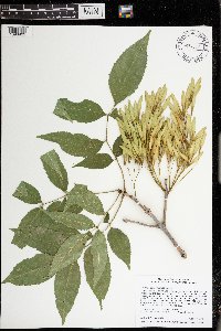 Fraxinus pennsylvanica Marshall 974558[1396922]Smith, Welby R WRS364272019-08-07 United States, Minnesota, McLeod, Liable Woods (Nature Conservancy preserve), about 4.9 km (3 miles) east of Biscay at a heading of 81 degrees., 44.834145 -94.21361 |
MIN:Plants | 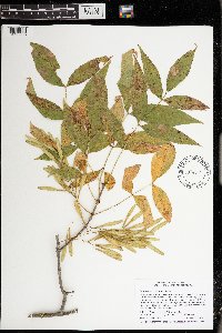 Fraxinus pennsylvanica Marshall 974544[1396908]Smith, Welby R WRS365152019-08-30 United States, Minnesota, Pine, Chengwatana State Forest, about 14 km (8.7 miles) due east of the approximate center of Pine City., 45.820457 -92.787623 |
MIN:Plants | Fraxinus pennsylvanica Marshall []J. C. B. Waddington 61966-05-05 United States, Minnesota, Hennepin, East shore of Cedar Lake, 44.959751 -93.317685 |
MIN:Plants | Fraxinus pennsylvanica Marshall []J.C.B. Waddington 61966-05-05 United States, Minnesota, Hennepin, on eats shore of Cedar Lake, 44.960055 -93.318115 |
MIN:Plants | 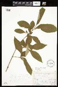 Syringa villosa Vahl 481085[1034078]Lakela, Olga 161841953-07-09 United States, Minnesota, Saint Louis, St. Louis County ... Hunters Hill at Duluth;;;;, 46.78333 -92.10639 |
MIN:Plants | 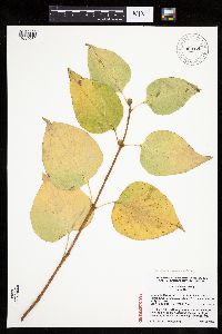 Syringa reticulata subsp. amurensis (F. Ruprecht) P.S. Greene & M.C. Chang 909125[1034070]Lee, C.; et al. 82008-10-12 United States, Minnesota, Ramsey, Ramsey Co, Como Park, 150 m east of Hamline Ave, south side of Midway Ave, just west of the mini golf course.;;029N;23W;22, 44.9805556 -93.1547222 |
MIN:Plants |  Syringa reticulata subsp. reticulata (Blume) H. Hara 914290[1034071]Schimpf, D. DJS5752009-09-06 United States, Minnesota, Saint Louis, St. Louis County, Duluth. T50N R14W SE1/4 Sec 13...NE side of London Rd.;;050N;14W;13, 46.8160413 -92.059779 |
MIN:Plants |  Syringa reticulata subsp. reticulata (Blume) H. Hara 906917[1034073]Schimpf, D.; Bollin, LeAnn DJS4992008-09-17 United States, Minnesota, Saint Louis, St. Louis County, Duluth. T50N R14W NE1/4 Sec 11...W of Tischer Creek;;050N;14W;11, 46.8344444 -92.0758333 |
MIN:Plants |  Syringa reticulata subsp. reticulata (Blume) H. Hara 906892[1034072]Schimpf, D.; Bollin, LeAnn DJS4862008-07-10 United States, Minnesota, Saint Louis, St. Louis County, Duluth. T50N R14W NE1/4 Sec 11...W of Tischer Creek;;050N;14W;11, 46.8344444 -92.0758333 |
MIN:Plants |  Syringa reticulata subsp. reticulata (Blume) H. Hara 914287[1034076]Schimpf, D. DJS5572009-07-18 United States, Minnesota, Saint Louis, St. Louis County, Duluth. T50N R14W SE1/4 Sec 13...NE side of London Rd.;;050N;14W;13, 46.8166667 -92.0513889 |
MIN:Plants |  Syringa reticulata subsp. reticulata (Blume) H. Hara 914286[1034075]Schimpf, D. DJS5452009-07-11 United States, Minnesota, Saint Louis, St. Louis County, Duluth. T49N R15W Sec 27...S side of Clyde Ave. between 93rd & 94th Aves. W.;;049N;15W;27, 46.7008333 -92.2175 |
MIN:Plants |  Syringa reticulata subsp. reticulata (Blume) H. Hara 914281[1034074]Schimpf, D. DJS5512009-07-13 United States, Minnesota, Saint Louis, St. Louis County, Duluth. T50N R14W Sec 13...Congdon Park Drive just below 4th St.;;050N;14W;13, 46.8191667 -92.0630556 |
MIN:Plants |  Syringa reticulata subsp. reticulata (Blume) H. Hara 914282[1034077]Schimpf, D. DJS5762009-09-06 United States, Minnesota, Saint Louis, St. Louis County, Duluth. T50N R14W Sec 13...Congdon Park Drive just below 4th St.;;050N;14W;13, 46.8191667 -92.0630556 |
MIN:Plants |  Syringa reticulata subsp. reticulata (Blume) H. Hara 914291[1034092]Schimpf, D. DJS5732009-09-06 United States, Minnesota, Saint Louis, St. Louis County, Duluth. T49N R15W Sec 27...S side of Clyde Ave. between 93rd & 94th Aves. W.;;049N;15W;27, 46.7008333 -92.2175 |
MIN:Plants |  Syringa japonica Decne. 171830[1002679]Wolfegg, S. [?] 1902-07-05 illegible |
MIN:Plants |  171774[1001805]Pringle, C.G. 69181898-07-30 Mexico, Hidalgo, Hills above Pachuca, 2591m |
MIN:Plants |  Chionanthus brassii (Kobuski) Kiew 916112[]Weiblen, G.D. & Binatang Research Center WP4C08702007-04-19 Papua New Guinea, Madang, Wanang Village, -5.2373 145.177183, 115m |
MIN:Plants |  Chionanthus brassii (Kobuski) Kiew 916121[]Weiblen, G.D. & Binatang Research Center WP4C29152007-04-06 Papua New Guinea, Madang, Wanang Village, -5.2373 145.177183, 115m |
MIN:Plants |  Chionanthus brassii (Kobuski) Kiew 916123[]Weiblen, G.D. & Binatang Research Center WP4E13222006-10-28 Papua New Guinea, Madang, Wanang Village, -5.2373 145.177183, 115m |
MIN:Plants |  Chionanthus brassii (Kobuski) Kiew 916109[]Weiblen, G.D. & Binatang Research Center WP5B10872007-10-09 Papua New Guinea, Madang, Wanang Village, -5.2373 145.177183, 115m |
MIN:Plants |  Chionanthus brassii (Kobuski) Kiew 916122[]Weiblen, G.D. & Binatang Research Center WP5B11132007-10-09 Papua New Guinea, Madang, Wanang Village, -5.2373 145.177183, 115m |
MIN:Plants | Chionanthus brassii (Kobuski) Kiew 922083[]Ctvrtecka, R. 31232008-11-06 Papua New Guinea, Madang, Wanang Village, -5.23088 145.182, 115m |
MIN:Plants |  Chionanthus ramiflorus Roxb. 921351[]Whitfeld, T.J.S. PA4C01972008-08-14 Papua New Guinea, Madang, Wanang Village, -5.237483 145.115733, 129m |
MIN:Plants | 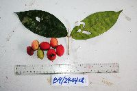 Chionanthus ramiflorus Roxb. 922076[]Ctvrtecka, R. 07972008-04-29 Papua New Guinea, Madang, Baitabag Village, -5.13333 145.767, 50m |
MIN:Plants | 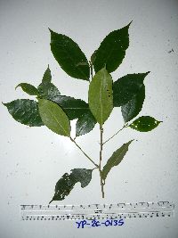 Chionanthus ramiflorus Roxb. 949662[1297981]Weiblen, G.D. YP2C01352011-02-22 Papua New Guinea, Morobe, Yawan Village, -6.163017 146.842983, 1732m |
MIN:Plants | 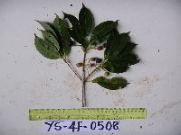 Chionanthus ramiflorus Roxb. 949665[1297983]Weiblen, G.D. YS4F05082010-09-10 Papua New Guinea, Morobe, Yawan Village, -6.16255 146.839933, 1721m |
MIN:Plants | 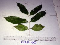 Chionanthus sessiliflorus (Hemsl.) Kiew 916118[]Weiblen, G.D. & Binatang Research Center WP1C00602006-05-23 Papua New Guinea, Madang, Wanang Village, -5.2373 145.177183, 115m |
MIN:Plants | 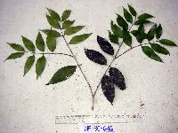 Chionanthus sessiliflorus (Hemsl.) Kiew 916164[]Weiblen, G.D. & Binatang Research Center WP3C06462007-03-31 Papua New Guinea, Madang, Wanang Village, -5.2373 145.177183, 115m |
MIN:Plants | 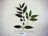 Chionanthus sessiliflorus (Hemsl.) Kiew 916124[]Weiblen, G.D. & Binatang Research Center WP4B09402007-08-11 Papua New Guinea, Madang, Wanang Village, -5.2373 145.177183, 115m |
MIN:Plants | 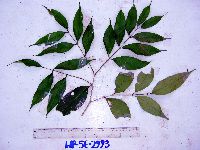 Chionanthus sessiliflorus (Hemsl.) Kiew 916115[]Weiblen, G.D. & Binatang Research Center WP5E29932007-04-13 Papua New Guinea, Madang, Wanang Village, -5.2373 145.177183, 115m |
MIN:Plants | 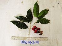 Chionanthus sessiliflorus (Hemsl.) Kiew 922082[]Ctvrtecka, R. 39622009-02-09 Papua New Guinea, Madang, Wanang Village, -5.23088 145.182, 115m |
MIN:Plants | Chionanthus sessiliflorus (Hemsl.) Kiew 896660[]Weiblen, G.D. TP3221996-07-31 Papua New Guinea, Simbu, O-Pio 1 ha plot, block 13, Crater Mountain Wildlife Management Area, -6.788611 145.036667, 550m |
Google Map
Google Maps is a web mapping service provided by Google that features a map that users can pan (by dragging the mouse) and zoom (by using the mouse wheel). Collection points are displayed as colored markers that when clicked on, displays the full information for that collection. When multiple species are queried (separated by semi-colons), different colored markers denote each individual species.