University of Minnesota
http://www.umn.edu/
612-625-5000
http://www.umn.edu/
612-625-5000
Minnesota Biodiversity Atlas
Bell Museum
Dataset: MIN-Plants
Taxa: Rhamnaceae
Search Criteria: excluding cultivated/captive occurrences
Bell Museum plants | |
 MIN:Plants | 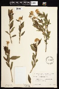 Ceanothus herbaceus Rafinesque 533120[1057130]Lakela, Olga 197411956-06-12 United States, Minnesota, Saint Louis, Side Lake 20 mi N of Hibbing;George Washington State Forest;N;;, 47.66528 -93.01556 |
MIN:Plants |  Ceanothus herbaceus Rafinesque 560886[1057126]Ownbey, Gerald; Anderson, Henry 27751959-07-01 United States, Minnesota, Clearwater, ca 5 mi straight-line mi due NE of Bagley. SE1/4 of section;;148N;37W;35, 47.59462 -95.33013 |
MIN:Plants |  Ceanothus herbaceus Rafinesque 560887[1057139]Ownbey, Gerald 26791959-06-14 United States, Minnesota, Hubbard, Hwy 92 ca 1 mi N of its jnc with hwy 71, near roadway;;N;;, 46.8489 -94.9958 |
MIN:Plants |  Ceanothus herbaceus Rafinesque 585517[1057158]Moore, John; et al. 260201962-06-06 United States, Minnesota, Houston, Houston County...3 1/2 mi SE of Caledonia near the upper end of Winnebago Valley;Dorer Memorial Hardwood State Forest;102N;05W;, 43.63068 -91.43198 |
MIN:Plants |  Ceanothus herbaceus Rafinesque 594234[1057131]Thorne, Robert 305391962-06-18 United States, Minnesota, Hubbard, ca 2 mi NW of Lake George;Paul Bunyan State Forest;N;;, 47.22103 -95.02346 |
MIN:Plants |  Ceanothus herbaceus Rafinesque 614607[1057134]Westkaemper, Remberta s.n.1968-06-00 United States, Minnesota, Stearns, Stearns Co. St. Joseph;;124N;29W;, 45.54364 -94.32205 |
MIN:Plants |  Ceanothus herbaceus Rafinesque 695847[1057156]Clemants, Steven 11231978-06-09 United States, Minnesota, Chisago, Goose Creek, 3 mi NE of Harris, T36N, R21W, intersection of S13, 14, 23, 24;;036N;21W;, 45.60063 -92.96037 |
MIN:Plants |  Ceanothus herbaceus Rafinesque 697932[1057107]Ownbey, Gerald 51791976-06-19 United States, Minnesota, Houston, Houston Co. 3.6 mi W of cemetery on W side of Hokah, US rte 16, T104N, R5W, SW1/4 S34;;104N;05W;34, 43.76774 -91.42281 |
MIN:Plants |  Ceanothus herbaceus Rafinesque 700593[1057132]Ownbey, Gerald 58261978-05-31 United States, Minnesota, Washington, Washington Co. T129N, R20W, W1/2 W1/2 S14 & E1/2 E1/2 S15, W side of Minn Rte 95;Saint Croix Savanna Scientific Natural Area;029N;20W;, 44.99172 -92.81421 |
MIN:Plants |  Ceanothus herbaceus Rafinesque 704583[1057121]Smith, Welby 16341979-08-16 United States, Minnesota, Wabasha, T109N, R9W, SW1/4 NE1/4 S18, 400 m due E of co rd 84;;109N;09W;18, 44.243599 -91.9391115 |
MIN:Plants |  Ceanothus herbaceus Rafinesque 717368[1057155]Mathisen, Ron 881979-06-26 United States, Minnesota, Hubbard, Spearhead Lake Reserve;Spearhead Lake Preserve (Audubon);145N;34W;, 47.3681 -94.99097 |
MIN:Plants |  Ceanothus herbaceus Rafinesque 717369[1057128]Grimmelbein, G. 1101979-07-04 United States, Minnesota, Hubbard, [no further data];Spearhead Lake Preserve (Audubon);145N;34W;, 47.3681 -94.99097 |
MIN:Plants |  Ceanothus herbaceus Rafinesque 738407[1057108]Galatowitsch, S. 1331982-05-29 United States, Minnesota, Wabasha, Wabasha County...Weaver Dunes: T109N R9W SE1/4 and E1/2 NE1/4 of Sec 7; NW1/4 and W1/2 NE1/4 of Sec 8;Kellogg-Weaver Dunes Scientific Natural Area / Kellogg-Weaver Dunes, The Nature Conservancy;109N;09W;00, 44.23311 -91.91725 |
MIN:Plants |  Ceanothus herbaceus Rafinesque 743833[1057116]Ownbey, Gerald 68521982-07-31 United States, Minnesota, Dakota, Dakota Co. Sand Coulee, E side of Minn. rt. 316, 1.9 mi SE of its jnc with U.S. rte 61 at Hastings; T114N R17W Sec. 11 N;;114N;17W;11, 44.69499 -92.82284 |
MIN:Plants |  Ceanothus herbaceus Rafinesque 750329[1057117]Almendinger, J. s.n.1982-08-00 United States, Minnesota, Beltrami, 3 1/2 mi NE of Wilton, NW of SW of S11, T147N, R34W;;147N;34W;11, 47.56343 -94.95989 |
MIN:Plants |  Ceanothus herbaceus Rafinesque 750357[1057145]Almendinger, J. 18001980-07-15 United States, Minnesota, Hubbard, 1/2 mi E of Mud Lake, NW of NW of S16, T139N, R32W;Badoura State Forest;139N;32W;16, 46.85509 -94.73385 |
MIN:Plants |  Ceanothus herbaceus Rafinesque 750585[1057102]Peterson, Jon 1071982-05-31 United States, Minnesota, Houston, Houston Co. Gap Hill #1; ca 4 mi W of Hokah on N side of Minn hwy 16, NW1/4 SW1/4 S34, T104N, R5W;Dorer Memorial Hardwood State Forest;104N;05W;34, 43.76774 -91.42281 |
MIN:Plants |  Ceanothus herbaceus Rafinesque 770047[1057104]Smith, Welby 77961983-06-04 United States, Minnesota, Wabasha, About 4 mi SE of Kellogg, on the E side of co rd 84, NW1/4 NE1/4 of section;Kellogg-Weaver Dunes Scientific Natural Area / Kellogg-Weaver Dunes, The Nature Conservancy;109N;09W;06, 44.27261 -91.93898 |
MIN:Plants |  Ceanothus herbaceus Rafinesque 825678[1057109]Cholewa, A.; et al. 1978a1991-06-01 United States, Minnesota, Cass, Itasca Co. [actually in Cass Co.], Chippewa National Forest, ca. 6 mi W of Bena on US hwy.2; T145N R29W S22.;Chippewa National Forest / Leech Lake Indian Reservation;145N;29W;22, 47.36075 -94.34241 |
MIN:Plants |  Ceanothus herbaceus Rafinesque 830208[1057103]Myhre, K. 20751992-06-03 United States, Minnesota, Cass, Cass County...Located directly west of the southwest shore of Pike Bay in Cass Lake..T145N R31W SW1/4 of SW1/4 of sec.27;Chippewa National Forest / Leech Lake Indian Reservation;145N;31W;27, 47.34504 -94.59711 |
MIN:Plants |  Ceanothus herbaceus Rafinesque 907638[1057112]Gerdes, Lynden; et al. 52742006-08-09 United States, Minnesota, Itasca, Chippewa National Forest / Leech Lake Indian Reservation. T145 R27W S12NWSESE. Itasca County, MN. Leech Lake Reservation. Chippewa National Forest. Bowstring State Forest. Approx 6.56 miles NW of Ball Club, MN and 1.53 miles S of Little Winnibigoshish Lake.. 145N 27W 12, 47.405078 -94.042826 |
MIN:Plants |  Ceanothus herbaceus Rafinesque 493384[1057105]Smith, Welby 267121997-07-22 United States, Minnesota, Cass, Cass County ... About 0.5 miles southeast of Pine River ...T137N R29W NE1/4 of SE1/4 of Sec 6;;137N;29W;06, 46.7097206 -94.3919449 |
MIN:Plants |  Ceanothus herbaceus Rafinesque 896961[1057113]Lake, Roger 01-122001-06-16 United States, Minnesota, Koochiching, Along County 31, about 2.6 km east of US 71 at Big Falls, near the south corner of Big Falls Airport. SW1/4 of NW1/4 of section;Koochiching State Forest;066N;27W;24, 48.1947 -93.75499 |
MIN:Plants |  Ceanothus herbaceus Rafinesque 915831[1057110]Whitfeld, T.J.S. 6782006-06-08 United States, Minnesota, Hubbard, Hubbard County...South of Cty. Hwy 109; 1/4 mile west of 279th Ave. ...UTM (NAD83): E365191 N5187903;;139N;32W;30, 46.8311111 -94.7677778 |
MIN:Plants |  Ceanothus herbaceus Rafinesque 896962[1057114]Lake, Roger 01-12001-05-27 United States, Minnesota, Koochiching, Along County 31, about 2.6 km east of US 71 at Big Falls, near the south corner of Big Falls Airport. SW1/4 of NW1/4 of section;Koochiching State Forest;066N;27W;24, 48.1947 -93.75499 |
MIN:Plants |  Ceanothus herbaceus Rafinesque 900932[1057141]Lee, Michael MDL39522005-06-10 United States, Minnesota, Becker, Two Inlets State Forest. Becker County...Two Inlets State Forest...along Cedar Lake Road on the west side of Hungry Man Lake, 1.5 miles south-southeast of Two Inlets...T141N R36W NE1/4 of NE1/4 Sec. 2. 141N 36W 2, 47.05805 -95.20198 |
MIN:Plants |  Ceanothus herbaceus Rafinesque 924534[1127421]Rowe, Erika ERR4212008-07-08 United States, Minnesota, Hubbard, 390 m west of pipeline opening; 111 m east of La Salle Creek; 3.2 miles SE of Vern. SENW of section.;;144N;35W;30, 47.2627778 -95.1641667 |
MIN:Plants |  Ceanothus herbaceus Rafinesque 932339[1127422]Tilden, Josephine 6 T-n1893-06-16 United States, Minnesota, Cass, Gull Lake;;;;, 46.446379 -94.35099 |
MIN:Plants |  Ceanothus herbaceus Rafinesque 942636[1283338]Dziuk, Peter M. 14152014-06-10 United States, Minnesota, Hubbard, Rockwood Township, SW road shoulder at junction of Highway 9 and 118., 47.357883 -94.968717 |
MIN:Plants |  Ceanothus herbaceus Rafinesque 961255[1334727]Stork, H. E. 1948-07-25 United States, Minnesota, Red Lake Indian Reservation, 48.0833 -95.0833 |
MIN:Plants |  Ceanothus herbaceus Rafinesque 961254[1334728]stork, H. E. 1925-06-00 United States, Minnesota, Itasca |
MIN:Plants |  Ceanothus herbaceus Rafinesque 961253[1334729]Marsh, Lucian United States, Minnesota, Cass |
MIN:Plants |  Ceanothus herbaceus Rafinesque 961377[1334834] United States, Wisconsin |
MIN:Plants | 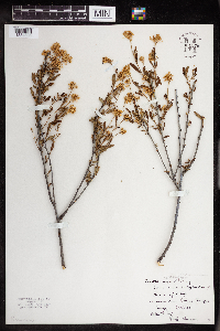 Ceanothus herbaceus Rafinesque 961376[1334835] United States, Wisconsin |
MIN:Plants |  Ceanothus cuneatus (Hooker) Nuttall 238650[1057096]Congdon, J. s.n.1902-05-11 United States, California, Mariposa, Pea Ridge Road, Mariposa County;Yosemite National Park;;;, 37.55 -119.9 |
MIN:Plants |  499025[1057483]Whitfeld, T.J.S. 3602002-07-18 United States, Minnesota, Pope, Pope County ... 2 miles north of Brooten. 200 yd west of Pope/Stearns county line ... T124N R36W NWSENE 24;;124N;36W;24, 45.53497 -95.14171 |
MIN:Plants |  437987[1057482]Smith, Welby 167751990-06-07 United States, Minnesota, Carver, Carver County ... In the Minnesota Valley, about 2 miles northwest of Shakopee ... T116N R23W NE1/4 of SW1/4 of Sec 35;;116N;23W;35, 44.8111111 -93.5575 |
MIN:Plants |  462094[1057452]Smith, Welby 290652000-08-31 United States, Minnesota, Anoka, Carlos Avery Wildlife Management Area. Anoka County ... Carlos Avery State Wildlife Management Area. On the west side of Linwood Lake, about 4.5 miles west of Wyoming (town) ... T 33N R 22W SE1/4 of NW1/4 of Sec 16. 033N 22W 16, 45.3491667 -93.0969444 |
MIN:Plants |  473188[1057462]Lee, Michael; et al. MDL23851998-08-18 United States, Minnesota, Stearns, Stearns Co.; Six miles south of St. Augusta; T122N R28W NE1/4 of SE1/4 Sec. 12;;122N;28W;12, 45.39136 -94.1486 |
MIN:Plants |  912140[1057478]Smith, Welby 253151994-08-26 United States, Minnesota, Goodhue, Goodhue County...In the Cannon River Valley, about 2 miles southeast of Welch...T 113N R 16W SW1/4 of NW1/4 of Sec 35;Dorer Memorial Hardwood State Forest;113N;16W;35, 44.5519444 -92.7111111 |
MIN:Plants |  461887[1057454]Smith, Welby 156371989-07-11 United States, Minnesota, Kanabec, Kanabek County ... on the northeast side of Highway 65, about 7.5 miles south of Mora ...NE1/4 SE1/4 sec 30, T 38N R 23W;;038N;23W;30, 45.7519455 -93.2508316 |
MIN:Plants |  453490[1057480]Smith, Welby 275931998-09-21 United States, Minnesota, Steele, Steele County ... Kaplans Woods City Park, on the south side of Owatonna ... T107N R20W NE1/4 of NW1/4 of Sec 21;;107N;20W;21, 44.0627778 -93.2397222 |
MIN:Plants |  386922[1057481]Cholewa, A. 25922006-07-14 United States, Minnesota, Anoka, Anoka County, City of Blaine, northeast corner of 121st Avenue and Aberdeen St. T31N R23W S8 NW1/4;;031N;23W;08, 45.1899 -93.23483 |
MIN:Plants |  489570[1057455]Smith, Welby 288012000-07-22 United States, Minnesota, Anoka, Anoka County ... In the City of Blaine, just south of 95th street and east of I35W ...T31N R23W SW1/4 of SW1/4 of Sec 26;;031N;23W;26, 45.1399994 -93.1713867 |
MIN:Plants |  493622[1057450]Smith, Welby 266801997-07-08 United States, Minnesota, Kanabec, Kanabec County ... About 4 miles north of Braham near the junction of Hwys 70 and 28 ... T 38N R 23W SW1/4 of SE1/4 of Sec 13. 038N 23W 13, 45.7772217 -93.1513901 |
MIN:Plants |  499649[1057485]Budelsky, R. RAB7531998-07-24 United States, Minnesota, Ramsey, [no further data];;029N;22W;21, 44.9847716 -93.0559436 |
MIN:Plants |  473186[1057461]Lee, Michael MDL21431998-06-16 United States, Minnesota, Wright, Wright Co.; floating mat severed by Hwy 55 on the southeast side of Maple Lake; T120N R26W NE1/4 of NW1/4 of NW1/4 Sec 9;;120N;26W;9, 45.21646 -93.96025 |
MIN:Plants |  371713[1057469]Lakela, Olga 47381941-08-12 United States, Minnesota, Saint Louis, Tischer Creek, Hunter's Hill, Duluth;;N;;, 46.81417 -92.05111 |
MIN:Plants |  375410[1057467]Lakela, Olga 49741942-07-01 United States, Minnesota, Saint Louis, Hunter's Hill, Duluth;;N;;, 46.78333 -92.10639 |
MIN:Plants |  391786[1057465]Lakela, Olga 60031945-07-04 United States, Minnesota, Saint Louis, Hunter's Hill, Duluth;;N;;, 46.78333 -92.10639 |
MIN:Plants |  430001[1057456]Smith, Welby 129731987-06-16 United States, Minnesota, Washington, East side of Highway 4, about 1/2 mile northwest of Marine on St. Croix; about 150 feet above the floodplain on the St. Croix River. SW1/4 NE1/4 of section;Saint Croix National Riverway;031N;20W;01, 45.2061111 -92.7797222 |
MIN:Plants |  441318[1057468]Kukachka, B. 8581938-05-21 United States, Minnesota, Ramsey, Shadow Falls, St. Paul;Shadow Falls Park;028N;23W;, 44.90516 -93.16646 |
MIN:Plants |  447518[1127452]Myhre, K. 3786A1993-06-08 United States, Minnesota, Pine, 10 miles east of Cloverdale. Crooked Creek. NE1/4 of NE1/4 of section;Saint Croix State Park;041N;17W;30, 45.997528 -92.525076 |
MIN:Plants | 463795[]Myhre, K. 3786A1993-06-08 United States, Minnesota, Pine, 10 miles east of Cloverdale. Crooked Creek. NE1/4 of NE1/4 of section;Saint Croix State Park;041N;17W;30, 45.997528 -92.525076 |
MIN:Plants |  481194[1057466]Lakela, Olga 161851953-07-09 United States, Minnesota, Saint Louis, Hunter's Hill, Duluth;;N;;, 46.78333 -92.10639 |
MIN:Plants |  508538[1057448]Lee, Michael MDL11001995-07-25 United States, Minnesota, Wabasha, Wabasha Co.; S-facing slope 3 1/2 mi SSW of Kellogg; T109N R10W NWSWNE 9;Dorer Memorial Hardwood State Forest;109N;10W;9, 44.25808 -92.01952 |
MIN:Plants |  568980[1057470]Moore, John; et al. 253221960-10-06 United States, Minnesota, Rice, 1/2 mi S of Shields Lake;;110N;22W;, 44.32669 -93.46404 |
MIN:Plants |  644848[1057472]Neese, E. 11081973-12-26 United States, Minnesota, Carver, Carver Co. 1/2 mi S of St. Hwy 7, 1/2 mi W of Co Rd 11, Carver State Park;Carver Park Reserve County Park;116N;24W;, 44.84796 -93.70478 |
MIN:Plants |  681255[1057464]Swanson, Steven 8021975-06-23 United States, Minnesota, Houston, Mississippi River (Navigation Pool #8), Houston Co, Site 26, N tip of Pettibone Island;Upper Mississippi National Wildlife Refuge;;;, 43.64899 -91.27441 |
MIN:Plants |  722506[1057471]Lustig, K. 9961979-08-23 United States, Minnesota, Anoka, 18 mi SE of Cambridge;Boot Lake Scientific Natural Area;033N;22W;, 45.34066 -93.08146 |
MIN:Plants |  746629[1057458]Smith, Welby 49411981-07-20 United States, Minnesota, Scott, Scott Co. On the W side of Savage, 1/2 mi S of State Hwy 13, in the Minnesota Valley; SE1/4 NE1/4 S17, T115N, R21W;;115N;21W;17, 44.76813 -93.369 |
MIN:Plants |  812349[1057463]Malody, K.J.A. 890441989-09-22 United States, Minnesota, Chisago, Chisago County...1.5 mi W of Rush Lake and 1.5 mi S of Hwy 2, SENWNW17, T37N, R22W;;037N;22W;17, 45.6991653 -93.1194458 |
MIN:Plants |  817530[1057484]Delaney, B. 890401989-06-20 United States, Minnesota, Isanti, ca 3 mi W of Cambridge, NE1/4 NW1/4 S2, T35N, R24W;;035N;24W;2, 45.55133 -93.29658 |
MIN:Plants |  829756[1057486]Fuge, E. 531993-08-06 United States, Minnesota, Dakota, Dakota Co. Koch Refinery property E of Hwy.55; T115N R18W NW1/4 of SW1/4 of Sec.18;;115N;18W;18, 44.76804 -93.02434 |
MIN:Plants |  841761[1057447]Smith, Welby 137291987-08-05 United States, Minnesota, Washington, About 5 mi W of Marine on St. Croix; NE1/4 NW1/4 of section;;031N;20W;08, 45.188378 -92.8653681 |
MIN:Plants |  920327[1057474]Smith, Welby 240121992-09-22 United States, Minnesota, Wabasha, Wabasha County ... Unnamed tributary of Snake Creek, about 3 miles south of Kellogg ... T109N R10W SE1/4 of NE1/4 of Sec 10. 109N 10W 10, 44.2591667 -91.9925 |
MIN:Plants |  493307[1057459]Smith, Welby 156491989-07-11 United States, Minnesota, Kanabec, Kanabec County ... northeast side of Highway 65, about 7.5 miles south of Mora ... NE1/4 SE1/4 section 30, T 38N R 23W;;038N;23W;30, 45.7519444 -93.2508333 |
MIN:Plants |  911914[1057477]Smith, Welby 230791993-07-22 United States, Minnesota, Carver, Carver County...At the northwest end of Lake St. Joe, about 2 mi north of Chaska...T 116N R 23W NE1/4 of NE1/4 of sec 7;;116N;23W;07, 44.875 -93.625 |
MIN:Plants |  906848[1057479]Pomroy, Deborah; et al. DLP26552008-08-22 United States, Minnesota, Saint Louis, St. Louis County, Hermantown. T50N R15W NW1/4 Sec 31. W end of wetland #4 ... Adolph Quadrangle. UTMs: approx. Zone 15T 554120E, 5180165N.. 050N 15W 31, 46.77139 -92.29087 |
MIN:Plants |  914865[1057475]Smith, Welby 252151994-08-19 United States, Minnesota, Pine, Banning State Park. Pine County...In Banning State Park, about 3 miles north-northwest of Sandstone...along the Kettle River...T43N R20W NW1/4 of SW1/4 of Sec 35. 043N 20W 35, 46.1625 -92.8402778 |
MIN:Plants |  478925[1057460]Carlson, Bruce 002861997-08-17 United States, Minnesota, Mille Lacs, Mille Lacs Kathio State Park. Mille Lacs Co.; Mille Lacs Kathio State Park, 0.5 miles NNE of the interpretive center; eastern side of Ogechi Lake; DNR Releve 7202. T42N R27W SWNE08. 042N 27W 8, 46.13508 -93.77658 |
MIN:Plants |  302326[1057487]Smith, Welby 288082000-07-25 United States, Minnesota, Aitkin, Aitkin County ... On the farm of John Menges, about 5 miles W-SW of Aitkin ... T47N R27W NE1/4 of SW1/4 of Sec 31;;047N;27W;31, 46.5111111 -93.8041667 |
MIN:Plants |  472664[1057453]Lee, Michael MDL22381998-07-08 United States, Minnesota, Carver, Carver Co.; Marsh Lake Hunting Club 2-1/2 mi. south of Victoria; T116N R24W SE1/4 of SE1/4 Sec. 26;;116N;24W;26, 44.82698 -93.67245 |
MIN:Plants |  912681[1057476]Lee, Michael; et al. MDL43562007-06-01 United States, Minnesota, Stearns, Stearns County ... St. Johns University Arboretum Woods. Southeast of Sagatagan Lake, two miles west of St. Joseph ... T124N R29W E1/2 of SE1/4 of NE1/4 Sec.7 ... UTM: 5046934N 393488E. 124N 29W 7, 45.56595 -94.37347 |
MIN:Plants | 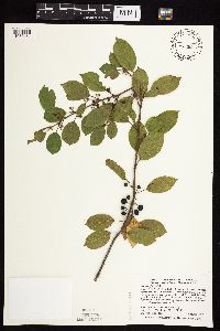 429024[1057451]Smith, Welby 289112000-08-05 United States, Minnesota, Anoka, Anoka County ... Pioneer Path City Park, in Blaine ... T31N R23W SE1/4 of Se1/4 of Sec 4;;031N;23W;04, 45.1991667 -93.2075 |
MIN:Plants | 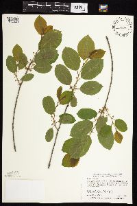 490554[1057449]Smith, Welby 284282000-05-15 United States, Minnesota, Anoka, Anoka County ... City of Blaine, just south of 95th street and east of I35W ... T 31N R 23W SW1/4 of SW1/4 of Sec 26;;031N;23W;26, 45.1399994 -93.1713867 |
MIN:Plants | 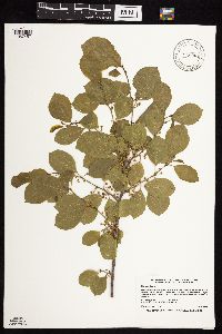 916905[1057457]Smith, Welby 223451993-06-08 United States, Minnesota, Carver, Carver County...Carver Park Reserve; about 5 miles west of Chanhassen...T 116N R 24W SE1/4 of NE1/4 of Sec 11;Carver Park Reserve County Park;116N;24W;11, 44.8716667 -93.6644444 |
MIN:Plants | 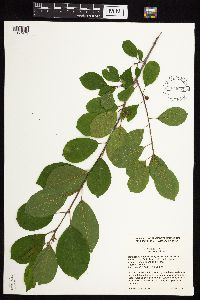 924651[1057473]Cholewa, A. 28172011-07-08 United States, Minnesota, Anoka, Island Lake, north of picnic area along trail around north end of lake.;Martin-Island-Linwood Lakes County Park;033N;22W;09, 45.371198 -93.096569 |
MIN:Plants |  922681[1127453]Peterson, S.; Gorvick, J. 052010-10-22 United States, Minnesota, Ramsey, Sucker Lake Park;Snail Lake Vadnais Lake County Park;;;, 45.07614 -93.09997 |
MIN:Plants |  921472[1127458]Smith, Welby 239981993-09-21 United States, Minnesota, Winona, About 3 miles west of Winona...T 107N R 8W NE1/4 of NW1/4 of Sec 24;;107N;08W;24, 44.0622222 -91.7313889 |
MIN:Plants |  934803[1127459]Whitfeld, T. J. S.; et al. 8982012-07-03 United States, Minnesota, Hennepin, UTM: 15T 457351E, 4981541N;Wood-Rill Scientific Natural Area;;;, 44.9860311 -93.5409944 |
MIN:Plants |  936098[1127460]Smith, Welby R. 324872011-06-09 United States, Minnesota, Sherburne, on the west side of Zimmerman. SE of SE of section;Fremont State Wildlife Management Area;034N;26W;18, 45.43 -93.6166106 |
MIN:Plants | 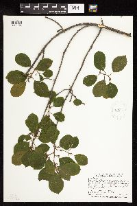 936258[1127461]Smith, Welby R. 326892011-06-21 United States, Minnesota, Rice, about one mile southwest of Shieldsville. SE of NE of section;Boyd Sartell State Wildlife Management Area;110N;22W;02, 44.3663167 -93.4240167 |
MIN:Plants | 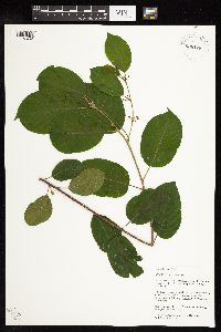 938128[1127462]Palmstrom, L.; Hamilton, R. 2013-12013-07-12 United States, Minnesota, Hennepin, Next to dock leading to Nine Mile Creek at Edina High School, 6754 Valley View Road, Edina;;;;, 44.870363 -93.410528 |
MIN:Plants | 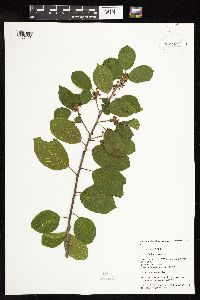 938022[1127456]Palmstrom, L.; Hamilton, R. 2013-242013-08-16 United States, Minnesota, Carver, 7025 Victoria Drive, Victoria, eastern edge of Parley Lake.;Carver Park Reserve County Park;;;, 44.874545 -93.712964 |
MIN:Plants | 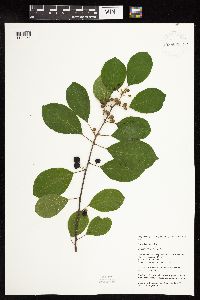 938021[1127454]Palmstrom, L.; Hamilton, R. 2012-232013-08-16 United States, Minnesota, Carver, Hazeltine Blvd, Chanhassen. Found by boat ramp at boat access 1.;Lake Minnewashta Regional Park;;;, 44.881235 -93.593566 |
MIN:Plants |  938020[1127457]Palmstrom, L.; Hamilton, R. 2013-222013-08-09 United States, Minnesota, Hennepin, Bredesen Park, 5901 Olinger Blvd, Edina. Interior path on west side of Mud Lake.;;;;, 44.894629 -93.379093 |
MIN:Plants |  938019[1127455]Palmstrom, L.; Hamilton, R. 2013-212013-08-09 United States, Minnesota, Hennepin, Bredesen Park, 5901 Olinger Bldv, Edina. On interior path on west side of Mud Lake;;;;, 44.894629 -93.379093 |
MIN:Plants |  497598[1282927]Palmstrom, L.; Hamilton, R. 2013-192313-08-09 United States, Minnesota, Hennepin, Bredesen Park, 5901 Olinger Blvd, Edina, MN. Found on the interor path on the west side of Mud lake;;;;, 44.894629 -93.379093 |
MIN:Plants |  221413[1282928]Palmstrom, L.; Hamilton, R. 2013-202013-08-09 United States, Minnesota, Hennepin, Bredesen Park, 5901 Olinger Blvd, Edina MN. Found on the interior path on the west side of Mud Lake.;;;;, 44.894629 -93.379093 |
MIN:Plants |  950076[1282926]Nee, M. 623532015-07-07 United States, Wisconsin, Richland, Smith Slough and Sand Prairie Natural Area, 1.15km W of Hwy 133. T8N R2E NW1/4 SW1/4 sect. 12, 43.181667 -90.211944, 210m |
MIN:Plants |  972937[1398490]Lee, Michael MDL55142011-06-02 United States, Minnesota, Stearns, Level terrain along old Highway 52 and County Road 134 (Ridgewood Road) south of the railroad tracks, on the west side of St. Cloud., 45.56169039 -94.25565039, 322m |
MIN:Plants | []J. C. B. Waddington 801966-06-01 United States, Minnesota, Hennepin, east Shore of Cedar Lake, 44.959812 -93.318544 |
MIN:Plants | Ceanothus thyrsiflorus Eschscholtz 520816[]Univ. of Calif. Bot. Gard. list 17 - 791974-00-00 United States, California, San Mateo, San Mateo Co. |
MIN:Plants |  909227[1057406]Smith, Welby 218681992-09-03 United States, Minnesota, Watonwan, Watonwan County...At the public access on the north side of Fedji Lake, about 2 miles northeast of Madelia...T 107N R 30W SW1/4 of SW1/4 of Sec 12. 107N 30W 12, 44.0816667 -94.3880556 |
MIN:Plants |  896589[1057427]Smith, Welby 292962002-06-11 United States, Minnesota, Wright, Wright County...Harry Larson County Forest, about 7 miles W-NW of Monticello...T 122N R 26W SW1/4 of SW1/4 of Sec 35;Harry Larson County Forest;122N;26W;35, 45.33323 -93.92151 |
MIN:Plants | 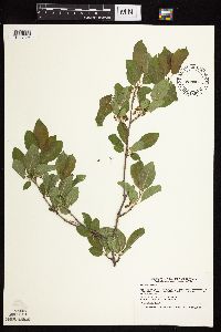 480851[1057394]Smith, Welby 166181990-05-17 United States, Minnesota, Martin, East Chain Wildlife Management Area. Martin County ... East Chain State Wildlife Management Area, about 1.5 miles north of the town of East Chain ... T 101N R 29W NE1/4 of SW1/4 of Sec 6. 101N 29W 6, 43.5797222 -94.3577778 |
MIN:Plants | 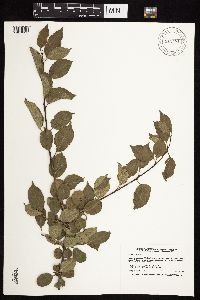 912481[1057351]Smith, Welby 229431993-07-15 United States, Minnesota, Fillmore, Beaver Creek Wildlife Management Area. Fillmore County ... Beaver Creek State Wildlife Management Area; about 9.5 miles south of Spriing Valley ... T101N R31W NE1/4 of SW1/4 of Sec 21. 101N 31W 21, 43.5341667 -92.4025 |
MIN:Plants | 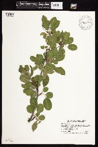 914372[1057384]Smith, Welby 225371993-06-22 United States, Minnesota, Stevens, Boekholt Grove Wildlife Management Area. Stevens County...Boekholt Grove State Wildlife Management Area, about 6.5 miles west-northwest of Donnelly...T126N R44W NW1/4 of NW1/4 of Sec 14. 126N 44W 14, 45.73 -96.17 |
MIN:Plants | 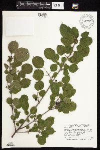 911323[1057405]Smith, Welby 253441994-09-01 United States, Minnesota, Houston, Upper Mississippi National Wildlife Refuge. Houston County...Upper Mississippi River Wildlife and Fish Refuge, about 1.5 miles east of La Crescent...Mississippi River...T 104N R 8W NE1/4 of NE1/4 of Sec 14. 104N 08W 14, 43.8175 -91.2755556 |
Google Map
Google Maps is a web mapping service provided by Google that features a map that users can pan (by dragging the mouse) and zoom (by using the mouse wheel). Collection points are displayed as colored markers that when clicked on, displays the full information for that collection. When multiple species are queried (separated by semi-colons), different colored markers denote each individual species.