University of Minnesota
http://www.umn.edu/
612-625-5000
http://www.umn.edu/
612-625-5000
Minnesota Biodiversity Atlas
Bell Museum
Dataset: MIN-Plants
Taxa: Rhamnaceae
Search Criteria: excluding cultivated/captive occurrences
Bell Museum plants | |
 MIN:Plants | 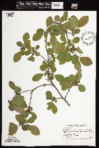 437988[1057323]Smith, Welby 166351990-05-21 United States, Minnesota, Steele, Steele County ... Kaplan Woods City Park, on the south side of Owatonna ... T107N R20W NE1/4 of NW1/4 of Sec 21;;107N;20W;21, 44.0644444 -93.235 |
MIN:Plants | 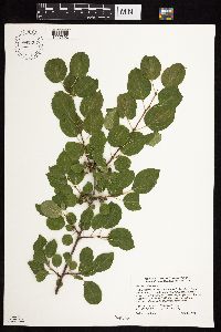 897207[1057392]Smith, Welby 273161998-06-29 United States, Minnesota, Itasca, Itasca County...On the west side of Deer River (town)...T 56N [should be T145] R 25W NW1/4 of NW1/4 of Sec 36;Leech Lake Indian Reservation;145N;25W;36, 47.3375 -93.7997222 |
MIN:Plants | 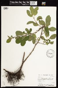 915845[1057344]Whitfeld, T.J.S. 6912006-06-21 United States, Minnesota, Hubbard, Hubbard County...On east bank of the Fishhook River; 3/4 mile west of the southern tip of Long Lake ... UTM (NAD 83): E345559 N5189798. 139N 35W 19, 46.8438889 -95.0255556 |
MIN:Plants | 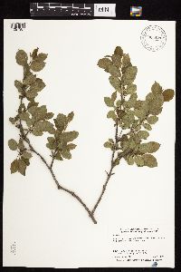 904479[1057387]Smith, Welby 277861999-05-23 United States, Minnesota, Aitkin, Aitkin County ... Along the Mississippi River on the east side of Palisade (town) ... T49N R25W SW1/4 of SW1/4 of Sec 23;;049N;25W;23, 46.7105556 -93.4819444 |
MIN:Plants |  459908[1057353]Kaul, R. 72271993-09-06 United States, Minnesota, Steele, Steele Co.; above Lemond Road by Straight River, Owatonna.;;107N;20W;, 44.06611 -93.22607 |
MIN:Plants |  474188[1057435]Stenberg, S. 12121997-08-08 United States, Minnesota, Sherburne, Sherburne National Wildlife Refuge;Sherburne National Wildlife Refuge;;;, 45.515 -93.71028 |
MIN:Plants |  870616[1057354]McCain, J. s.n.1996-10-01 United States, Minnesota, Chisago, rest park on I-35 Highway N of Harris, Chisago Co.;;036N;21W;, 45.60063 -92.96037 |
MIN:Plants |  489432[1057322]Smith, Welby 287552000-07-18 United States, Minnesota, Ramsey, Ramsey County ... Swede's Hollow City Park, in St. Paul ... T29N R22W SE1/4 of NW1/4 of Sec 32;;029N;22W;32, 44.9577778 -93.0763889 |
MIN:Plants | 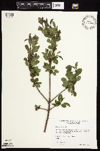 510991[1057434]Wheeler, Gerald 195911999-05-14 United States, Minnesota, Pipestone, Pipestone County ... NW edge of Pipestone; Hiawatha State Game Refuge ... N1/2 NW1/4 Sec. 1 T106N R46W (Sweet 1);Pipestone Wildlife Management Area;106N;46W;1, 44.01585 -96.31767 |
MIN:Plants | 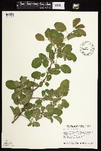 435321[1057370]Smith, Welby 152431989-06-03 United States, Minnesota, Nobles, Nobles Co.; About 1.5 miles west of Adrian. East-facing bluff on Kanaranze Creek; NW1/4 NW1/4 section 14, T 102N R 43W. 102N 43W 14, 43.6433334 -95.9638901 |
MIN:Plants | 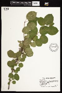 914653[1057341]Smith, Welby 226231993-06-29 United States, Minnesota, Swift, Swift County...Lake Monson State Park, about 17 miles northwest of Wilmar [sic]...T 121N R 37W SW1/4 of NW1/4 of Sec 1;Monson Lake State Park;121N;37W;01, 45.3236111 -95.2688889 |
MIN:Plants | 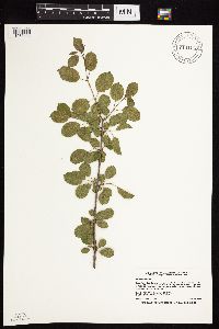 914156[1057408]Smith, Welby 225141993-06-18 United States, Minnesota, Douglas, Douglas County...Lake Carlos State Park, about 6 miles north of Alexandria...T 129N R 37W SE1/4 of SW1/4 of Sec 9;Lake Carlos State Park;129N;37W;09, 45.9958333 -95.3469444 |
MIN:Plants |  477053[1057393]Lee, Michael MDL23341998-07-31 United States, Minnesota, Morrison, Belle Prairie County Park. Morrison County ... Belle Prairie County Park along the Mississippi River 1/2 mile north of Belle Prairie ... T41N R32W NW1/4 of NE1/4 Sec. 14. 041N 32W 14, 46.03466 -94.34031 |
MIN:Plants |  913996[1057383]Smith, Welby 227841993-07-09 United States, Minnesota, Rock, Blue Mounds State Park. Rock County...Blue Mounds State Park, about 4 miles north-northeast of Luverne...adjacent to the Mound Creek.. T 103N R 45W NW1/4 of NW1/4 of Sec 24. 103N 45W 24, 43.7163889 -96.1897222 |
MIN:Plants |  900009[1057389]Smith, Welby 271761998-06-01 United States, Minnesota, Mille Lacs, Kunkel Wildlife Management Area. Mille Lacs County...Kunkel State Wildlife Management Area, about 4.5 miles west of Princeton...T36N R27W SW1/4 of NE1/4 of Sec 26. 036N 27W 26, 45.5841667 -93.6638889 |
MIN:Plants |  913910[1057345]Smith, Welby 252081994-08-19 United States, Minnesota, Pine, Pine County... In Banning State Park, about 3 miles NNW of Sandstone...Kettle River...T43N R20W NW1/4 of SW1/4 of Sec 35;Banning State Park;043N;20W;35, 46.1625 -92.8402778 |
MIN:Plants | 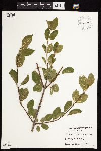 906309[1057407]Smith, Welby 154871989-06-27 United States, Minnesota, Anoka, Anoka County...About 2 miles southwest of Linwood...north side of Devils Lake. SE1/4 SW1/4 section 14, T33N R23W;;33N;23W;14, 45.3484 -93.17476 |
MIN:Plants | 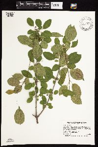 913657[1057346]Smith, Welby 227311993-07-02 United States, Minnesota, Becker, Dunton County Park. Becker County... In Dunton County Park, about 3 miles southwest of Detroit Lakes...Muskrat Lake...T138N R41W SE1/4 of NE1/4 of Sec 8. 138N 41W 8, 46.7825 -95.8816667 |
MIN:Plants | 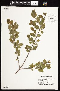 920161[1057337]Smith, Welby 221731993-05-20 United States, Minnesota, Otter Tail, Otter Tail County...Maplewood State Park about 7 miles southeast of Pelican Rapids...T135N R42W NW1/4 of NW1/4 of Sec 11;Maplewood State Park;135N;42W;11, 46.5269444 -95.945 |
MIN:Plants | 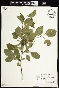 477285[1057430]Smith, Welby 205941992-06-25 United States, Minnesota, Redwood, Redwood County ... In Alexander Ramsey city park in Redwood Falls ... Redwood River Valley ... T 113N R 36W NW1/4 of SE1/4 of Sec 36. 113N 36W 36, 44.5480537 -95.1244431 |
MIN:Plants |  528387[1057440]Lee, Michael MDL20361998-05-19 United States, Minnesota, Stearns, In the city limits of Waite Park. NE1/4 of SW1/4 Sec.;Quarry Park Nature Preserve & Scientific Natural Area;124N;28W;20, 45.53717 -94.22949 |
MIN:Plants |  904112[1057388]Smith, Welby 280501999-07-21 United States, Minnesota, Murray, Murray County ... Lake Shetek State Park, about 3 miles NW of Currie ... T107N R40W NW1/4 of NW1/4 of Sec 6;Lake Shetek State Park;107N;40W;06, 44.1077778 -95.6969444 |
MIN:Plants |  904558[1057385]Smith, Welby 263841996-08-27 United States, Minnesota, Saint Louis, Superior National Forest. St. Louis County...About 1/2 mile north of the town of Ely...abandoned railroad right-of-way...T63N R12W NE1/4 of SE1/4 of Sec 28. 063N 12W 28, 47.91 -91.8652778 |
MIN:Plants |  352709[1057414]Eneboe, H. 421937-06-28 United States, Minnesota, Hennepin, Barge terminal S of Washington Avenue bridge, Minneapolis;;;;, 44.98 -93.26361 |
MIN:Plants |  380194[1057418]Lakela, Olga 54041943-08-17 United States, Minnesota, Saint Louis, Hunters Hill, Duluth;;N;;, 46.78333 -92.10639 |
MIN:Plants |  381313[1057419]Moore, John; Harden, P. 143311942-05-17 United States, Minnesota, Ramsey, Hidden Falls beyond the Ford Plant;Hidden Falls - Crosby Farm Regional Park;028N;23W;, 44.90516 -93.16646 |
MIN:Plants |  412919[1057326]Moore, John; Moore, Marjorie 114211939-08-03 United States, Minnesota, Roseau, S side of the Warroad River, Warroad.;;N;;, 48.90639 -95.29861 |
MIN:Plants |  421059[1057377]Lakela, Olga 105691950-06-29 United States, Minnesota, Saint Louis, Congdon River terrace below Superior Street, Duluth;;;;, 46.78333 -92.10639 |
MIN:Plants |  429503[1057362]Smith, Welby 209141992-07-15 United States, Minnesota, Marshall, Old Mill State Park. Marshall Co.; In Old Mill State Park, about 11 miles east of Argyle; along the Middle River; Marshall Co.; In Old Mill State Park, about 11 miles east of Argyle; along the Middle River; T 156N R 46W NW1/4 of SE1/4 of Sec 4. 156N 46W 4, 48.3602791 -96.5702744 |
MIN:Plants |  429806[1057359]Smith, Welby 153511989-06-11 United States, Minnesota, Le Sueur, LeSueur [sic] Co.; In the Minnesota Valley, about 1.5 miles south of Ottawa; NW1/4 SE1/4 section 3, T 110N R 26W;Ottawa Bluffs, The Nature Conservancy;110N;26W;3, 44.3624992 -93.9363861 |
MIN:Plants |  429832[1057371]Smith, Welby 153151989-06-06 United States, Minnesota, Chisago, Wild River State Park. Chisago County...St. Croix Wild River State Park, about 5.5 miles south-southeast of Rush City; SW1/4 SE1/4 section 13, T 36N R 321W. 036N 21W 13, 45.601944 -92.9016647 |
MIN:Plants |  430054[1057361]Smith, Welby 153911989-06-14 United States, Minnesota, Chisago, Saint Croix National Riverway. Chisago County...In the St. Croix Valley, about 5 miles south-southwest of Taylors Falls...NW1/4 NW1/4 section 22, T 33N R 19W. 033N 19W 22, 45.3283348 -92.7125015 |
MIN:Plants | 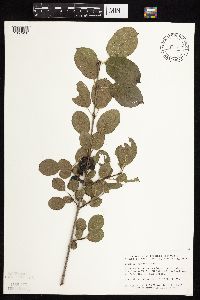 430137[1057416]Smith, Welby 139281987-09-01 United States, Minnesota, Scott, Scott Co. Murphy-Hanrahan Regional Park, about 2 mi W of Burnsville; SW1/4 NW1/4 sec.34, T115N R21W;Murphy-Hanrahan County Park Reserve;115N;21W;34, 44.72472 -93.33345 |
MIN:Plants | 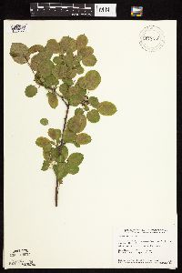 430779[1057382]Smith, Welby 152131989-05-31 United States, Minnesota, Freeborn, Carex Wildlife Management Area. Freeborn County...'Carex' State Wildlife Management Area, about 7 miles east-southeast of Hollandale. NW1/4 NW1/4 section 23, T 103N R 19W. 103N 19W 23, 43.7155556 -93.0866667 |
MIN:Plants | 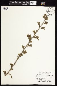 432956[1057363]Myhre, K. 54121995-05-23 United States, Minnesota, Mahnomen, Wambach Wildlife Management Area / White Earth Indian Reservation. Mahnomen Co.; Located 5 miles northeast of the town of Mahnomen; Wildlife Management Area; T 145N R 42W SW1/4 of NE1/4 o Mahnomen Co.; Located 5 miles northeast of the town of Mahnomen; Wildlife Management Area; T 145N R 42W SW1/4 of NE1/4 of sec 12. 145N 42W 12, 47.39068 -95.94398 |
MIN:Plants | 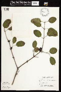 439685[1057396]Boe, J. 931001011993-10-01 United States, Minnesota, Cass, Cass Co. On bank of Mosquito Creek N of Crow Wing River.;;133N;31W;7, 46.34304 -94.64837 |
MIN:Plants | 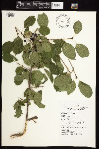 441801[1057355]Kruse, K. 070 KMK1994-08-29 United States, Minnesota, Goodhue, Frontenac State Park. Goodhue County; T: 112N R: 13W Sec: 11 Quarter Sec: NE NW; site #3.;Frontenac State Park;112N;13W;11, 44.51999 -92.33923 |
MIN:Plants | 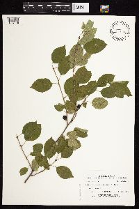 454223[1057446]Mortensen, Steve LL1747B1999-10-24 United States, Minnesota, Itasca, Plants of Leech Lake Reservation and Chippewa National Forest; proposed Deer River casino site. T145N, R25W, SWSW26;Leech Lake Indian Reservation;145N;25W;26, 47.3464 -93.8059 |
MIN:Plants | 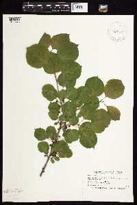 457080[1057443]Smith, Welby 186571991-06-05 United States, Minnesota, Redwood, Redwood Co.; in the Minnesota Valley, about 3.5 miles north of Belview; T 114N R 37W NE of SE1/4 of Sec 19 Redwood Co.; in the Minnesota Valley, about 3.5 miles north of Belview; T 114N R 37W NE1/4 of SE1/4 of Sec 19. 114N 37W 19, 44.6630554 -95.461113 |
MIN:Plants | 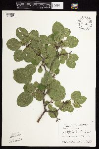 459370[1057421]Smith, Welby 158071989-07-18 United States, Minnesota, Freeborn, Freeborn Co.; at the S end of Geneva Lake, about 3 mi NE of Clarks Grove. NE1/4 NE1/4 sec.30, T104N R20W;;104N;20W;30, 43.78203 -93.27945 |
MIN:Plants | 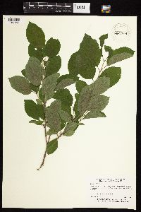 460294[1057356]Myhre, K. 26931992-07-13 United States, Minnesota, Cass, Cass Co.; Located one mile north of the Crow Wing River; T 133N R 31W SW1/4 of NW1/4 of Sec 15;;133N;31W;15, 46.33323 -94.56972 |
MIN:Plants | 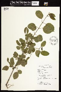 466728[1057324]Kruse, K. 034 KMK1994-05-29 United States, Minnesota, Goodhue, Frontenac State Park. Goodhue Co.; T: 112N R: 13W Sec: 11 Quarter Sec: NW NW; site #2.;Frontenac State Park;112N;13W;11, 44.51999 -92.33923 |
MIN:Plants | 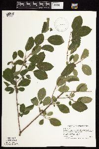 475905[1057395]Smith, Welby 212461992-08-05 United States, Minnesota, Olmsted, Bear Cave County Park. Olmsted Co.; Bear Cave County Park, on the west side of Stewartville; T 105N R 14W SW1 Olmsted Co.; Bear Cave County Park, on the west side of Stewartville; T 105N R 14W SW1/4 of NE1/4 of sec 33. 105N 14W 33, 43.9263878 -92.4958344 |
MIN:Plants | 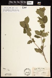 501566[1057347]Stevens, O. s.n.1954-09-14 United States, Minnesota, Pipestone, Along quarry;Pipestone National Monument;106N;46W;01, 44.0158476 -96.3176691 |
MIN:Plants | 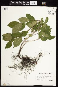 504883[1057397]Smith, Welby 190361991-06-30 United States, Minnesota, Aitkin, Aitkin Co.; Karen Myhre's homestead, about 3.5 mi W-NW of Glen; T46N R26W NE1/4 of NE1/4 Aitkin Co.; Karen Myhre's homestead, about 3.5 mi W-NW of Glen; T46N R26W NE1/4 of NE1/4 of Sec 26. 046N 26W 26, 46.4444427 -93.5769424 |
MIN:Plants | 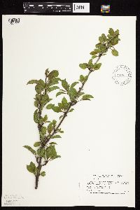 508189[1057444]Smith, Welby 185481991-05-21 United States, Minnesota, Todd, Todd Co.; about 1 mi SE of Osakis; between CSAH 46 and the BN railroad tracks; Todd Co.; about 1 mi SE of Osakis; between CSAH 46 and the BN railroad tracks; T128N R35W SW1/4 of NE1/4 of sEc 31. 128N 35W 31, 45.8549995 -95.1263885 |
MIN:Plants | 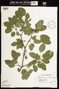 514304[1057441]Smith, Welby 189581991-06-25 United States, Minnesota, Todd, Grey Eagle Wildlife Management Area. Todd Co.; Grey Eagle State Wildlife Management Area, about 3 miles W of Grey Eagle; Todd Co.; Grey Eagle State Wildlife Management Area, about 3 miles W of Grey Eagle; T127N R33W SW1/4 of SE1/4 of sEc 10. 127N 33W 10, 45.8191681 -94.815834 |
MIN:Plants | 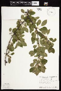 518800[1057424]Smith, Welby 147341988-08-04 United States, Minnesota, Benton, Sartell Wildlife Management Area. Benton County...Sartell State Wildlife Management Area, about 2 miles northeast of Rice; SW1/4 SW1/4 sec.15, T 38N R 31W. 038N 31W 15, 45.786582 -94.186232 |
MIN:Plants | 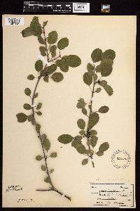 526593[1057413]Merrell, Ted s.n.1947-09-28 United States, Minnesota, Rice, Northfield, N of St. Olafs.;;;;, 44.45833 -93.16139 |
MIN:Plants | 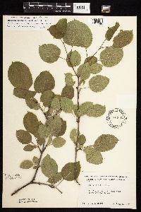 542632[1057348]Moore, John 217541952-06-05 United States, Minnesota, Watonwan, Along the SW shore of Wood Lake;;107N;33W;, 44.06508 -94.79901 |
MIN:Plants | 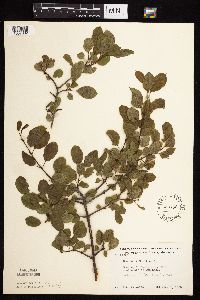 553732[1057332]Moore, John 225101955-06-01 United States, Minnesota, Sibley, Sibley Co. E shore of Mud Lake;;114N;28W;33, 44.63761 -94.20321 |
MIN:Plants | 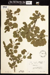 553915[1057378]Moore, John 227841956-06-09 United States, Minnesota, Clay, along the Red River 2 mi S of Moorhead;;N;;, 46.8447 -96.77994 |
MIN:Plants | 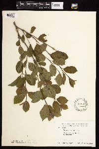 566652[1057330]Moore, John 239151958-06-14 United States, Minnesota, Kittson, Hallock;;N;;, 48.77444 -96.94611 |
MIN:Plants | 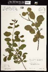 574396[1057350]Moore, John 245531959-06-03 United States, Minnesota, Blue Earth, 2 mi N of Mankato;;;;, 44.19258 -93.99917 |
MIN:Plants | 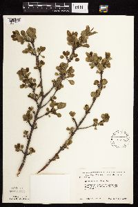 585538[1057325]Moore, John 259131962-05-11 United States, Minnesota, Houston, along rr 7 mi SW of Caledonia;;N;;, 43.56298 -91.59573 |
MIN:Plants | 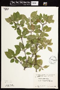 603860[1057334]Moore, John; Hsi, Yu-tseng [Eugene] 271511967-06-15 United States, Minnesota, Winona, 1 1/2 mi W of St. Charles;;106N;10W;, 43.9770486 -92.0191664 |
MIN:Plants | 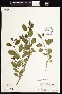 603911[1057379]Moore, John; Moore, Marjorie 271051967-06-09 United States, Minnesota, Pipestone, Pipestone Co.; east of rr tracks, Pipestone National Monument;Pipestone National Monument;106N;46W;, 43.97972 -96.36786 |
MIN:Plants | 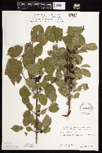 619824[1057411]Ownbey, Gerald 43631970-09-06 United States, Minnesota, Washington, 0.5 mi. W of Afton.;;028N;20W;, 44.90717 -92.81202 |
MIN:Plants | 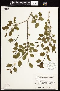 623137[1057333]Moore, John 273371970-06-04 United States, Minnesota, Anoka, W side of Cedar Creek, below bridge on Hwy 24, Cedar Creek Natural History Area;Cedar Creek National History Area;034N;23W;, 45.40217 -93.199397 |
MIN:Plants | 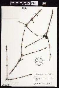 643813[1057417]Ownbey, Gerald 47451973-12-02 United States, Minnesota, Washington, .5 mi w of Afton village, near Afton Hills Driver.;;028N;20W;, 45.10119 -92.77212 |
MIN:Plants | 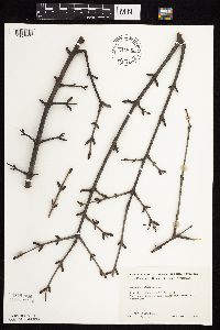 644885[1057335]Neese, E. 10741973-12-19 United States, Minnesota, Ramsey, Ramsey Co.; between Lake Emily and Emmert St, Shoreview.;;030N;23W;, 45.08003 -93.16693 |
MIN:Plants | 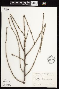 644886[1057331]Neese, E. 10751973-00-00 United States, Minnesota, Ramsey, Ramsey Co.; between Lake Emily and Emmert St, Shoreview.;;030N;23W;, 45.08003 -93.16693 |
MIN:Plants | 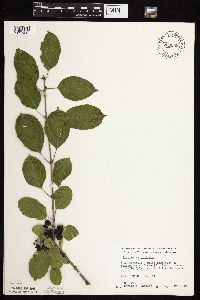 709959[1057415]Wheeler, Gerald 49881979-09-17 United States, Minnesota, Washington, Washington Co.; Ca. 4 mi. NE of Stillwater on Rte. 95. In a floodplain woods of the St. Croix River. T30N, R19W [shoul Washington Co.; Ca. 4 mi. NE of Stillwater on Rte. 95. In a floodplain woods of the St. Croix River. T30N, R19W [should be R20], Sec. 11.. 030N 20W 11, 45.10119 -92.77212 |
MIN:Plants | 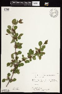 727859[1057380]Lustig, K. 4391979-06-08 United States, Minnesota, Sherburne, Mississippi River Islands Scientific Natural Area. Sherburne & Wright Cos. ...Mississippi Scenic and Recreational River Islands SNA: Mississippi River Islands between Monticello and Elk River, Sec. 2, 3, 4, T32N, R26, 27W; Sec. 7, 9, 18, T121N, R23, 24W. 032N 26W 3, 45.29348 -93.55625 |
MIN:Plants | 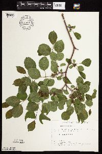 728455[1057372]Eikum, B. 691979-06-03 United States, Minnesota, Dakota, Hastings;Hastings Scientific Natural Area;115N;17W;, 44.73907 -92.86266 |
MIN:Plants |  730124[1057374]Converse, C. 81980-05-21 United States, Minnesota, Chisago, Chisago Co. Rush Lake Island Natural Area: 7 mi W-SW of Rush City, NE1/4 NW1/4 S28, T37N, R22W;Rush Lake Island Scientific Natural Area;037N;22W;28, 45.6662 -93.09382 |
MIN:Plants |  739984[1057364]Converse, C. 8441982-05-24 United States, Minnesota, Pope, N1/2 and N1/2 SE1/4 of S30, SW1/4 and S1/2 S1/2 SE1/4 of S19;Ordway Prairie, The Nature Conservancy;123N;36W;, 45.4558171 -95.1933416 |
MIN:Plants |  740052[1057409]Converse, C. 9951982-06-07 United States, Minnesota, Douglas, NW1/4 NE1/4 and NE1/4 NW1/4 of section;Staffanson Prairie, The Nature Conservancy;127N;40W;18, 45.810665 -95.7480052 |
MIN:Plants |  745182[1057327]Smith, Welby 40691981-06-03 United States, Minnesota, Wright, Wright Co.; between State Hwy 24 and Clearwater lake, about 3 mi NNW of Annandale, NW1/4 SW1/4 S9, T121N, R27W;;121N;27W;9, 45.30431 -94.08662 |
MIN:Plants |  745515[1057437]Smith, Welby 44711981-06-24 United States, Minnesota, Mower, About 2 1/4 mi E of the junction of State Hwy 56 and Co Hwy 2 in Brownsdale. SE1/4 SW1/4 of section;Wild Indigo Scientific Natural Area;103N;17W;12, 43.7396 -92.81924 |
MIN:Plants |  747096[1057349]Galatowitsch, S. 4741982-07-16 United States, Minnesota, Rice, S1/2 NW1/4 SW1/4 of Sec. 20 and part of NE1/4 SE1/4 Sec. 19.;Cannon River Trout Lily Scientific Natural Area;110N;20W;, 44.3268919 -93.2219425 |
MIN:Plants |  747212[1057329]Galatowitsch, S. 5101982-07-16 United States, Minnesota, Goodhue, Grace Nature Preserve: T109N, R18W, parts of NW1/4 SW1/4 and SW1/4 SW1/4 of Sec. 8.;Grace Nature Preserve, The Nature Conservancy;109N;18W;8, 44.26201 -93.01054 |
MIN:Plants | 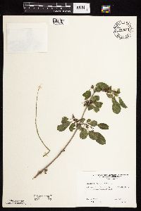 749544[1057376]Ehritt, K. s.n.1977-05-15 United States, Minnesota, Le Sueur, Le Sueur Co. Ottawa Bluffs: NE1/4 Sec. 3, T110N, R26W;Ottawa Bluffs, The Nature Conservancy;110N;26W;3, 44.36262 -93.93938 |
MIN:Plants | 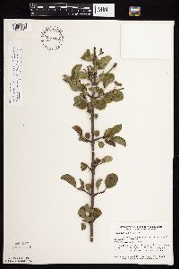 759200[1057410]Smith, Welby 73011982-08-15 United States, Minnesota, Wright, On the S side of US Hwy 12, about 1 mi E of Howard Lake. NW1/4 NW1/4 of section;;118N;27W;02, 45.05825 -94.04297 |
MIN:Plants | 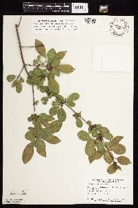 770724[1057365]Smith, Welby 90091983-06-04 United States, Minnesota, Mower, About 1 mi NNW of LeRoy. SW1/4 SW1/4 of section;Lake Louise State Park;101N;14W;21, 43.5365784 -92.5190432 |
MIN:Plants | 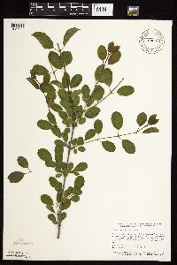 789657[1057328]Smith, Welby 101561985-05-27 United States, Minnesota, Hennepin, Wolsfeld Woods State Sceintific and Natural Area, ca 2 1/2 mi W of Plymouth, SW1/4 NE1/4 S27, T118N, R23W;Wolsfeld Woods Scientific Natural Area;118N;23W;27, 45.002224 -93.5730591 |
MIN:Plants | 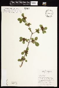 800170[1057366]Cholewa, A. 16251989-05-23 United States, Minnesota, Washington, Directly E of administration building (also along S Railroad trail);Carpenter Nature Center;026N;20W;04, 44.76881 -92.81362 |
MIN:Plants | 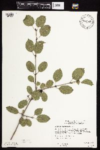 815647[1057423]Wheeler, Gerald 124151988-09-27 United States, Minnesota, Big Stone, Ca. 3.5 mi. NNE of Ortonville; E of Rte. 7. W1/2 Sec. 29, T12N, R46W (Big Stone Twp.).;;122N;46W;29, 45.347949 -96.461577 |
MIN:Plants | 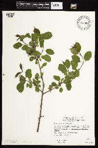 815840[1057381]Wheeler, Gerald 104491988-05-24 United States, Minnesota, Norman, Ca. 1 mi. E of Twin Valley; Wild Rice River (N bank). On bluffs overlooking river. N1/2 SW1/4 Sec. 26, T144N, R44W (Wi Ca. 1 mi. E of Twin Valley; Wild Rice River (N bank). On bluffs overlooking river. N1/2 SW1/4 Sec. 26, T144N, R44W (Wild Rice Twp.). 144N 44W 26, 47.25981 -96.2262 |
MIN:Plants | 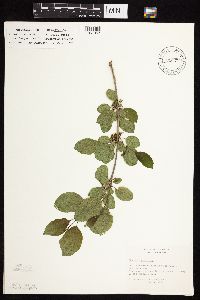 816270[1057367]Bender, J. s.n.1986-05-14 United States, Minnesota, Washington, [no further data];Belwin Outdoor Education Laboratory;028N;20W;10, 44.9271878 -92.7918522 |
MIN:Plants |  817534[1057360]Delaney, B. 890571989-07-05 United States, Minnesota, Isanti, Isanti Co. 0.5 mi S-SW of S end of Long Lake. NW1/4 NE1/4 sec.8, T34N R24W.;;034N;24W;8, 45.4497 -93.3575 |
MIN:Plants |  818131[1057422]Olson, J. s.n.1989-07-21 United States, Minnesota, Winona, Winona Co. Vic. of Rollingstone, T107N, R08W, SW1/4 NW1/4 Sec. 5; SW-facing slope.;;107N;08W;5, 44.09944 -91.81011 |
MIN:Plants |  833558[1057398]Juhnke, C. 2941991-09-09 United States, Minnesota, Fillmore, Forestville State Park. Fillmore Co. T102N R12W Sec.24 SE SW SW;Forestville State Park;102N;12W;24, 43.62341 -92.21915 |
MIN:Plants |  833738[1057358]Smith, Welby 141391988-05-31 United States, Minnesota, Lac Qui Parle, Lac Qui Parle Co. About 11 mi S-SW of Madison; NE1/4 NW1/4 sec.9, T116N R45W;;116N;45W;9, 44.87061 -96.28626 |
MIN:Plants | 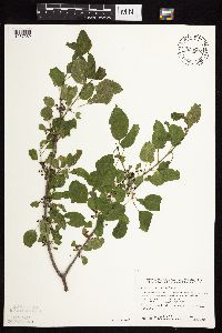 833802[1057369]Smith, Welby 140821988-05-30 United States, Minnesota, Lac Qui Parle, Lac Qui Parle County...About 3 mi W of Montevideo...ravine that drains N into the Minnesota River. NE1/4 NE1/4 sec.21, T117N R41W. 117N 41W 21, 44.9281 -95.80856 |
MIN:Plants | 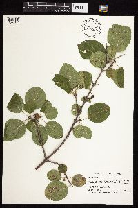 834244[1057357]Smith, Welby 198901991-07-31 United States, Minnesota, Todd, Todd Co. About 2 mi S of Grey Eagle, public access at the NW end of Big Birch Lake; Todd Co. About 2 mi S of Grey Eagle, public access at the NW end of Big Birch Lake; T127N R32W NE1/4 of SE1/4 of Sec 19. 127N 32W 19, 45.7952766 -94.7508316 |
MIN:Plants | 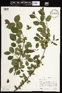 834848[1057445]Haferman, J. 831995-06-02 United States, Minnesota, Scott, Scott Co. T115N R22W S36 SW of SW. Approx. 0.1 mi N-NE of intersection of State Hwy.13 and Co. Rd.44 on N side of hwy;;115N;22W;36, 44.72459 -93.40903 |
MIN:Plants | 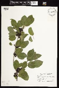 839274[1057420]Smith, Welby 184681990-09-19 United States, Minnesota, Fillmore, Lost Lake Wildlife Management Area. Fillmore Co. Along the Root River Trail, in the Root River Valley. About 1.25 mi W of Lanesboro; Fillmore Co. Along the Root River Trail, in the Root River Valley. About 1.25 mi W of Lanesboro; T103N R10W NW1/4 of NW1/4 of Sec 23.. 103N 10W 23, 43.7138901 -92.0036087 |
MIN:Plants | 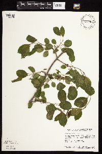 840498[1057375]Smith, Welby 126891987-05-16 United States, Minnesota, Goodhue, Goodhue County...Hay Creek Recreation Area, about 2 mi S of Red WIng...NE1/4 NE1/4 sec.12, T112N R15W;Dorer Memorial Hardwood State Forest;112N;15W;12, 44.5247231 -92.5538864 |
MIN:Plants | 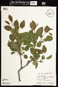 841031[1057373]Smith, Welby 127421987-05-23 United States, Minnesota, Dakota, Dakota Co. In the Minnesota Valley, about 1 mi E of Savage; NE1/4 SW1/4 sec.32, T27N R24W;;027N;24W;32, 44.7816658 -93.3174973 |
MIN:Plants | 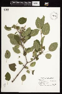 898974[1057386]Smith, Welby 258001995-08-01 United States, Minnesota, Kandiyohi, Kandiyohi County ... Sibley State Park, about 5 miles west of New London ... T121N R35W SW1/4 of NE1/4 of Sec 1;Sibley State Park;121N;35W;01, 45.32 -95.0161111 |
MIN:Plants | 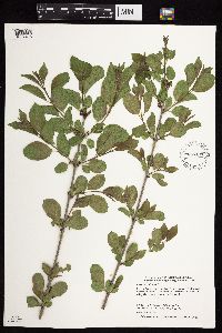 897141[1057426]Smith, Welby 27012 United States, Minnesota, Crow Wing, Crow Wing State Park. Crow Wing County...In Crow Wing State Park, about 7 miles north of Fort Ripley...east bank of the Crow Wing River... T 44N R 32W SW1/4 of SW1/4 of Sec 26. 044N 32W 26, 46.2622222 -94.3425 |
MIN:Plants |  916895[1057342]Smith, Welby 223461993-06-08 United States, Minnesota, Carver, Carver County...Carver Park Reserve; about 5 miles west of Chanhassen...T 116N R 24W SE1/4 of NE1/4 of Sec 11;Carver Park Reserve County Park;116N;24W;11, 44.8716667 -93.6644444 |
MIN:Plants | 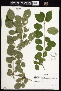 899117[1057425]Pomroy, Deborah; et al. DLP24472007-07-18 United States, Minnesota, Saint Louis, Cloquet Valley State Forest. St. Louis County, North Star Township. T53N R13W SE1/4 of SE1/4 Sec 14. 1/2 mi E of SE corner of Briar Lk.... UTM zone 15T, 0580112E, 5213339N...Cloquet Valley State Forest. 053N 13W 14, 47.07581 -91.95313 |
MIN:Plants | 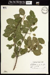 913775[1057401]Smith, Welby 243921994-06-14 United States, Minnesota, Chippewa, Chippewa County... In the Minnesota Valley about 2 miles northwest of Granite Falls... T116N R39W SW1/4 of SW1/4 of Sec 21.. 116N 39W 21, 44.8361111 -95.5636111 |
MIN:Plants | 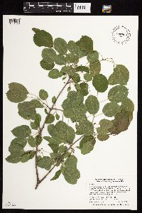 898960[1057390]Smith, Welby 271441998-05-26 United States, Minnesota, Pine, Pine County...At the public access on the Snake River, in Pine City...between the railroad tracks and the river... T 39N R 21W SW1/4 of SE1/4 of Sec 28. 039N 21W 28, 45.8311111 -92.9705556 |
MIN:Plants | 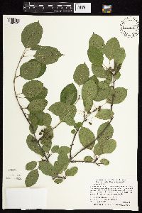 489418[1057432]Smith, Welby 288862000-08-02 United States, Minnesota, Goodhue, Goodhue County ... Frontenac State Park, about 2 miles N-NE of Frontenac (town) ... T112N R13W NW1/4 of SE1/4 of Sec 2;Frontenac State Park;112N;13W;02, 44.5341682 -92.3349991 |
MIN:Plants | 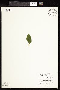 870617[1127430]McCain, J. s.n.1996-09-30 United States, Minnesota, Pine, 5.5 mi E of Hinckley;Kettle River Scientific Natural Area / Sandstone National Wildlife Refuge;041N;20W;, 46.013408 -92.841832 |
MIN:Plants | 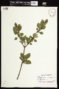 431694[1057428]Smith, Welby 166811990-05-24 United States, Minnesota, Olmsted, Olmsted County ... In Oxbow County Park, about 3 miles north of Byron ... T107N R15W NW1/4 of SW1/4 of Sec 8;Oxbow County Park;107N;15W;08, 44.086113 -92.6544418 |
MIN:Plants | 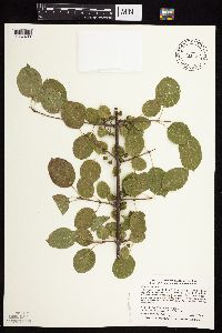 429034[1057439]Smith, Welby 287592000-07-18 United States, Minnesota, Ramsey, Ramsey County ... Battle Creek County Park, in St. Paul ... T 28N R 22W SE1/4 of SE1/4 of sec 3;Battle Creek County Park;028N;22W;03, 44.9361115 -93.0280533 |
Google Map
Google Maps is a web mapping service provided by Google that features a map that users can pan (by dragging the mouse) and zoom (by using the mouse wheel). Collection points are displayed as colored markers that when clicked on, displays the full information for that collection. When multiple species are queried (separated by semi-colons), different colored markers denote each individual species.