University of Minnesota
http://www.umn.edu/
612-625-5000
http://www.umn.edu/
612-625-5000
Minnesota Biodiversity Atlas
Bell Museum
Dataset: MIN-Plants
Taxa: Rhynchospora
Search Criteria: excluding cultivated/captive occurrences
Bell Museum plants | |
 MIN:Plants | Rhynchospora capillacea Torrey 815461[1105168]Wheeler, Gerald United States, Minnesota, Norman, Detailed locality information protected. This is typically done to protect rare or threatened species localities. |
MIN:Plants | Rhynchospora capillacea Torrey 818119[1105126]Watson, W. United States, Minnesota, Pope, Detailed locality information protected. This is typically done to protect rare or threatened species localities. |
MIN:Plants | Rhynchospora capillacea Torrey 82738[1105181]Sandberg, John United States, Minnesota, Hennepin, Detailed locality information protected. This is typically done to protect rare or threatened species localities. |
MIN:Plants | Rhynchospora capillacea Torrey 82739[1105180]Sandberg, John United States, Minnesota, Hennepin, Detailed locality information protected. This is typically done to protect rare or threatened species localities. |
MIN:Plants | Rhynchospora capillacea Torrey 82740[1105130]Leiberg, John United States, Minnesota, Blue Earth, Detailed locality information protected. This is typically done to protect rare or threatened species localities. |
MIN:Plants | Rhynchospora capillacea Torrey 82741[1105146]Leiberg, John United States, Minnesota, Blue Earth, Detailed locality information protected. This is typically done to protect rare or threatened species localities. |
MIN:Plants | Rhynchospora capillacea Torrey 82742[1105164]Leiberg, John United States, Minnesota, Blue Earth, Detailed locality information protected. This is typically done to protect rare or threatened species localities. |
MIN:Plants | Rhynchospora capillacea Torrey 831694[1105119]Harris, Fred United States, Minnesota, Pennington, Detailed locality information protected. This is typically done to protect rare or threatened species localities. |
MIN:Plants | Rhynchospora capillacea Torrey 836078[1105122]Smith, Welby United States, Minnesota, Redwood, Detailed locality information protected. This is typically done to protect rare or threatened species localities. |
MIN:Plants | Rhynchospora capillacea Torrey 836097[1021650]Smith, Welby United States, Minnesota, Redwood, Detailed locality information protected. This is typically done to protect rare or threatened species localities. |
MIN:Plants | Rhynchospora capillacea Torrey 841285[1021647]Smith, Welby United States, Minnesota, Nobles, Detailed locality information protected. This is typically done to protect rare or threatened species localities. |
MIN:Plants |  Rhynchospora fusca (L.) W.T. Aiton 417524[1105222]Lakela, Olga 110431950-08-03 United States, Minnesota, Saint Louis, Near Wahlsten Station, S of Soudan on Hwy. 35.;;N;;, 47.770841 -92.280068 |
MIN:Plants |  Rhynchospora fusca (L.) W.T. Aiton 436633[1105187]Myhre, K. 5166A1994-07-05 United States, Minnesota, Itasca, Itasca Co.; located 2.7 miles southwest of the town of Bigfork; T 60N R 26W SW1/4 of SW1/4 of Sec 5;Chippewa National Forest;060N;26W;5, 47.713566 -93.673252 |
MIN:Plants |  Rhynchospora fusca (L.) W.T. Aiton 447650[1105193]Gerdes, Lynden; et al. 35911999-07-18 United States, Minnesota, Lake, T60N R10W S04SENWNW. Lake Co. Superior National Forest, Shamrock Lake. Sphagnum wetland south/adjacent to lake.;Superior National Forest;060N;10W;04, 47.712224 -91.609877 |
MIN:Plants |  Rhynchospora fusca (L.) W.T. Aiton 459208[1021694]Myhre, K. 48131994-05-23 United States, Minnesota, Itasca, Itasca Co.; located 3 mi SW of the town of Bigfork; edge of a tiny bog lake; T60N R26W SW1/4 of SW1/4 of Sec 5;Chippewa National Forest;060N;26W;5, 47.713566 -93.673252 |
MIN:Plants |  Rhynchospora fusca (L.) W.T. Aiton 519239[1105184]Walton, G. 25581997-07-28 United States, Minnesota, Lake, Superior National Forest; T59N, R7W, sw1/4 of se1/4 Sec.5, Cabin Lake...Lake Co.;Superior National Forest;059N;07W;05, 47.6188889 -91.2463913 |
MIN:Plants |  Rhynchospora fusca (L.) W.T. Aiton 519241[1105189]Walton, G. 25641997-07-29 United States, Minnesota, Lake, Superior National Forest; T59N, R7W, ne1/4 of ne1/4 Sec.8, Cabin Lake ... Lake Co.; at north end of Section 8 Lake.;Superior National Forest;059N;07W;08, 47.609006 -91.246571 |
MIN:Plants |  Rhynchospora fusca (L.) W.T. Aiton 519322[1105192]Scott, P. 9021996-08-16 United States, Minnesota, Cook, Cook Co. Fiddle Pond T63N R1W sec.2 NSW.;Superior National Forest;063N;01W;2, 47.968892 -90.415147 |
MIN:Plants |  Rhynchospora fusca (L.) W.T. Aiton 526900[1021696]Lakela, Olga 178761954-07-14 United States, Minnesota, Saint Louis, Mucky lake on Hwy. 35, N of Wahlsten Station, W side of the hwy.;;N;;, 47.762072 -92.280068 |
MIN:Plants |  Rhynchospora fusca (L.) W.T. Aiton 681743[1021693]Wheeler, Gerald 11951977-07-08 United States, Minnesota, Beltrami, Ca. 13 mi. N of Waskish on hwy. 72.;Red Lake Peatland Scientific Natural Area;156N;31W;1, 48.359967 -94.564698 |
MIN:Plants |  Rhynchospora fusca (L.) W.T. Aiton 698215[1105241]Wheeler, Gerald; Glaser, Paul 30151978-06-21 United States, Minnesota, Beltrami, Red Lake Peatland; ca. 12.5 mi. NW of the Waskish Airport. Ovoid Islands Area; ca 1 1/4 mi. SW of Camp No. 1.;Red Lake Peatland Scientific Natural Area;156N;32W;25, 48.303133 -94.695865 |
MIN:Plants |  Rhynchospora fusca (L.) W.T. Aiton 698240[1105185]Wheeler, Gerald; Glaser, Paul 30401978-06-24 United States, Minnesota, Beltrami, Red Lake Peatland; ca. 14 mi. NW of the Waskish Airport. Ovoid Islands Area; 1 1/4 mi. N of Camp No. I.;Red Lake Peatland Scientific Natural Area;156N;32W;24, 48.317655 -94.695853 |
MIN:Plants |  Rhynchospora fusca (L.) W.T. Aiton 698382[1021692]Wheeler, Gerald; Glaser, Paul 31831978-07-13 United States, Minnesota, Beltrami, Ca. 18 mi. NW of the Waskish Airport. Western Water Track Area.;Red Lake Wildlife Management Area;155N;33W;10, 48.259416 -94.871126 |
MIN:Plants |  Rhynchospora fusca (L.) W.T. Aiton 698409[1105223]Wheeler, Gerald; Glaser, Paul 32101978-07-13 United States, Minnesota, Beltrami, Red Lake Peatland; ca. 20.5 mi. NW of the Wasskish Airport. Western Water Track.;Red Lake Peatland Scientific Natural Area;156N;33W;32, 48.288445 -94.914767 |
MIN:Plants |  Rhynchospora fusca (L.) W.T. Aiton 698449[1105240]Wheeler, Gerald; Glaser, Paul 32501978-07-15 United States, Minnesota, Beltrami, Red Lake Peatland Scientific Natural Area. Red Lake Peatland: Ca. 16 mi. NW of the Waskish Airport. Western edge of Ovoid Islands Area; ca. 0.25 mi. SW of Camp N Red Lake Peatland: Ca. 16 mi. NW of the Waskish Airport. Western edge of Ovoid Islands Area; ca. 0.25 mi. SW of Camp No. II.. 156N 32W 15, 48.332043 -94.742064 |
MIN:Plants |  Rhynchospora fusca (L.) W.T. Aiton 698603[1105237]Wheeler, Gerald; Glaser, Paul 33341978-08-31 United States, Minnesota, Beltrami, Red Lake Peatland Scientific Natural Area. Red Lake Peatland; ca. 14 mi. NW of the Waskish Airport. Ovoid Islands Area; ca. 1 1/4 mi. N of Camp No. I. Site No. 3 Red Lake Peatland; ca. 14 mi. NW of the Waskish Airport. Ovoid Islands Area; ca. 1 1/4 mi. N of Camp No. I. Site No. 30.. 156N 32W 24, 48.317655 -94.695853 |
MIN:Plants |  Rhynchospora fusca (L.) W.T. Aiton 698623[1021691]Wheeler, Gerald; Glaser, Paul 33541978-08-31 United States, Minnesota, Koochiching, Koochiching Co. Red Lake Peatland; Ca. 8.5 mi. E of Rte. 72 and 10.5 mi. N-NE of the Waskish Airport. Koochiching Area.;Red Lake Peatland Scientific Natural Area;156N;29W;15, 48.33164 -94.348902 |
MIN:Plants |  Rhynchospora fusca (L.) W.T. Aiton 698633[1021690]Wheeler, Gerald; Glaser, Paul 33641978-08-31 United States, Minnesota, Koochiching, Koochiching Co. Red Lake Peatland; ca. 8.5 mi. E of Rte. 72 and 10.5 mi. N-NE of the Waskish Airport. Koochiching Area.;Red Lake Peatland Scientific Natural Area;156N;29W;16, 48.33103 -94.370741 |
MIN:Plants |  Rhynchospora fusca (L.) W.T. Aiton 702001[1021695]Glaser, Paul 10531979-08-14 United States, Minnesota, Saint Louis, Ca. 2 1/2 mi. N of Alborn on Hwy. 7.;;052N;18W;12, 47.004984 -92.565638 |
MIN:Plants |  Rhynchospora fusca (L.) W.T. Aiton 702227[1105239]Glaser, Paul 11251979-09-06 United States, Minnesota, Saint Louis, 1 1/2 mi. E of Nichols Lake on Co. Rd. 232.;;053N;17W;16, 47.076292 -92.502944 |
MIN:Plants |  Rhynchospora fusca (L.) W.T. Aiton 702233[1105238]Glaser, Paul 11041979-08-26 United States, Minnesota, Saint Louis, Ca. 10 mi. E of Babbitt.;Superior National Forest;060N;12W;13, 47.68044 -91.806543 |
MIN:Plants | 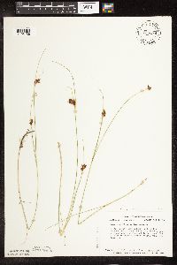 Rhynchospora fusca (L.) W.T. Aiton 726394[1105186]Smith, Welby 31931980-08-06 United States, Minnesota, Saint Louis, Between Co. Rd. 7 and 220, ca. 2 mi. N of Alborn.;;052N;18W;12, 47.004984 -92.565638 |
MIN:Plants | 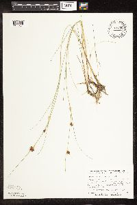 Rhynchospora fusca (L.) W.T. Aiton 781398[1105231]Smith, Welby 97191984-07-27 United States, Minnesota, Beltrami, Red Lake Peatlands, ca. 12 mi. NW of Waskish.;Red Lake Peatland Scientific Natural Area;156N;32W;36, 48.288757 -94.695736 |
MIN:Plants | 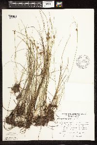 Rhynchospora fusca (L.) W.T. Aiton 794368[1105191]Glaser, Paul 11581980-07-03 United States, Minnesota, Saint Louis, Babbitt Fen, 10 mi. E of Babbitt on the S side of Tomahawk Trail, near the boundary of St. Louis and Lake Co. Releve' 5.. T060N R12W S13, 47.680441 -91.806543 |
MIN:Plants | 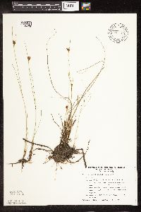 Rhynchospora fusca (L.) W.T. Aiton 794417[1105228]Glaser, Paul 11591980-07-03 United States, Minnesota, Saint Louis, Superior National Forest. Babbitt Fen,10 mi. E of Babbitt on the S side of Tomahawk Trail, near the boundary between St. Louis and Lake Co. Relev Babbitt Fen,10 mi. E of Babbitt on the S side of Tomahawk Trail, near the boundary between St. Louis and Lake Co. Releve' 5.. T060N R12W S13, 47.680441 -91.806543 |
MIN:Plants |  Rhynchospora fusca (L.) W.T. Aiton 834396[1105190]Smith, Welby 200401991-08-24 United States, Minnesota, Lake, Superior National Forest. Lake County...About 16 mi NW of Isabella and about 1 mi W of Hwy 1 on FR 424 (Denley Rd)...T60N R11W SW1/4 of SE1/4 of Sec 1.. 060N 11W 1, 47.7075005 -91.6619415 |
MIN:Plants |  Rhynchospora fusca (L.) W.T. Aiton 836291[1105230]Karns, K. 8239011982-08-12 United States, Minnesota, Saint Louis, N of a black spruce stand by approx. 100 meters; S of FR 424. Lake Co. 13 SENE T60N R12W [this is St. Loius Co.];Superior National Forest;060N;12W;13, 47.68044 -91.806543 |
MIN:Plants |  Rhynchospora fusca (L.) W.T. Aiton 909892[1105258]Milburn, Scott; et al. SAM08-0292008-07-15 United States, Minnesota, Lake, Lake County...Easting 591,249 Northing 5,283,641 - UTM 15. T 60N R 11W SW Sec 7;Superior National Forest;060N;11W;07, 47.6994444 -91.7838889 |
MIN:Plants |  Rhynchospora fusca (L.) W.T. Aiton 480928[1105246]Scott, P. 20132005-09-02 United States, Minnesota, Lake, LAKE CO ... Island in Kawishiwi River, BWCAW. T63N R6W sec.3 NWSWNW.;Boundary Waters Canoe Area Wilderness / Superior National Forest;063N;06W;03, 47.969177 -91.079423 |
MIN:Plants | 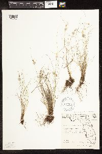 Rhynchospora floridensis (Britton) H. Pfeiffer 607998[1105183]Craighead, F.; et al. 262001963-08-13 United States, Florida, Dade, Dade county. Southwest of Homestead. Everglades National Park ... near the service drive.;Everglades National Park |
MIN:Plants | Rhynchospora capillacea Torrey 483999[1105161]Anderson, Craig United States, Minnesota, Becker, Detailed locality information protected. This is typically done to protect rare or threatened species localities. |
MIN:Plants | 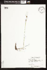 Rhynchospora fusca (L.) W.T. Aiton 438573[1105243]Perry, Ethan 20050292005-06-28 United States, Minnesota, Lake, Lake County...3.5 miles northwest of the Highway 2 boat landing on Greenwood Lake...T58N R11W NWNW2;Superior National Forest;058N;11W;02, 47.539336 -91.687675 |
MIN:Plants | 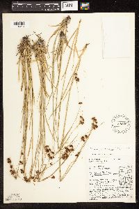 Rhynchospora globularis (Chapman) Small 528826[1105274]Umbach, L. 40161909-06-20 United States, Indiana, Porter, Northern Porter County ... Dune Park on Lake Michigan (7 mi. E. of Gary, Ind, SE of Chicago);Indiana Dunes National Lakeshore;;;, 41.663093 -87.032128 |
MIN:Plants | 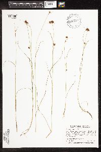 Rhynchospora fusca (L.) W.T. Aiton 490669[1105242]Shedd, M. S21996-08-20 United States, Minnesota, Lake, Superior National Forest. Lake County ... Superior National Forest, Kawishiwi Rd, Isabella. Just west of Bandana lake ... T60N R9W NE1/4 of NE1/4 of Sec 25. 060N 09W 25, 47.653491 -91.416607 |
MIN:Plants |  Rhynchospora fusca (L.) W.T. Aiton 498954[1105236]Anderson, Chel 20582004-08-06 United States, Minnesota, Cook, Cook County ... T62N R5W Sec.29 NE1/4 of SW1/4;Superior National Forest;062N;05W;29, 47.824151 -90.989323 |
MIN:Plants |  Rhynchospora fusca (L.) W.T. Aiton 490444[1105226]Gerdes, Lynden 48582004-07-07 United States, Minnesota, Lake, Superior National Forest. T58N R08W S21SWSW. Lake County...Superior National Forest. Approximately 2.81 miles SSW of Isabella, MN and 1.12 miles NNE of Crown Lake.. 058N 08W 21, 47.494443 -91.352677 |
MIN:Plants |  Rhynchospora fusca (L.) W.T. Aiton 918192[1105264]Anderson, Chel 21172009-08-28 United States, Minnesota, Cook, Cook County ... At south end of east arm of Copper Lake in BWCAW ... T64N R4W Sec.10 SE1/4 of NW1/4;Boundary Waters Canoe Area Wilderness / Superior National Forest;064N;04W;10, 48.041052 -90.82061 |
MIN:Plants |  Rhynchospora fusca (L.) W.T. Aiton 479337[1105233]Scott, P. 14162002-08-25 United States, Minnesota, Cook, COOK CO ... W end of Finn Lake, BWCAW. T64N R3W sec. 14 SENESW.;Boundary Waters Canoe Area Wilderness / Superior National Forest;064N;03W;14, 48.024908 -90.666569 |
MIN:Plants |  Rhynchospora fusca (L.) W.T. Aiton 480926[1105232]Scott, P. 14742003-07-28 United States, Minnesota, Cook, Cook County ... NW of Frost Lake, BWCAW. T64N R4W Sec.27 SESWNW.;Boundary Waters Canoe Area Wilderness / Superior National Forest;064N;04W;27, 47.997469 -90.820935 |
MIN:Plants |  Rhynchospora fusca (L.) W.T. Aiton 461956[1105229]Lee, Michael MDL26881999-08-10 United States, Minnesota, Lake, North Shore. Lake County ... Along Blesner Creek 6-1/2 miles northeast of Finland. along County Road 7, opposite its jct. with the Sonju Lake Forest Road ... T58N R6W SW1/4 of NE1/4 of NE1/4 Sec. 31. 058N 06W 31, 47.465115 -91.139684 |
MIN:Plants |  Rhynchospora nitens (Vahl) A. Gray 82640[1105277]Chase, Agnes 9201898-08-18 United States, Indiana, Porter, Dune Park;Indiana Dunes National Lakeshore;;;, 41.663093 -87.032128 |
MIN:Plants |  Rhynchospora alba (L.) Vahl 478109[1021628]Lee, Michael MDL24151998-08-26 United States, Minnesota, Morrison, Camp Ripley Military Reservation. Morrison County ... Camp Ripley National Guard Base ... 81/2 miles south of Pillager ... T132N R30W NE1/4 of NE1/4 Sec. 28, NW1/4 of NW1/4 Sec. 27. 132N 30W 28 &27, 46.238733 -94.454743 |
MIN:Plants | Rhynchospora capillacea Torrey 909930[1105167]Milburn, Scott; et al. United States, Minnesota, Polk, Detailed locality information protected. This is typically done to protect rare or threatened species localities. |
MIN:Plants | 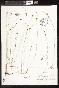 Rhynchospora fusca (L.) W.T. Aiton 427080[1105234]Gerdes, Lynden 53192006-09-05 United States, Minnesota, Lake, Superior National Forest. T59N R11W S05NWSENE. Lake County, MN. Superior National Forest. Finland State Forest. Approx. 10.21 miles SE of Babbit, MN and 2.27 miles ENE of Lake Culkin.. 059N 11W 5, 47.626467 -91.751007 |
MIN:Plants | 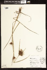 Rhynchospora macrostachya Torrey ex A. Gray 531660[1105275]Umbach, L. 15001906-09-04 United States, Indiana, Porter, Northern Porter County ... Dune Park on Lake Michigan (7 mi. E. of Gary, Ind, SE of Chicago);Indiana Dunes National Lakeshore;;;, 41.663093 -87.032128 |
MIN:Plants | 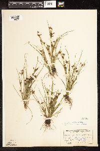 Rhynchospora nitens (Vahl) A. Gray 82645[1105276]Umbach, L. s.n.1899-09-12 United States, Indiana, Porter, Dune Park;Indiana Dunes National Lakeshore;;;, 41.663093 -87.032128 |
MIN:Plants | 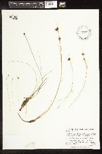 Rhynchospora fusca (L.) W.T. Aiton 515275[1105235]Zager, S. 1512001-08-01 United States, Minnesota, Cook, Superior National Forest. Cook County...Superior National Forest...one-forth mile south of Fox and Soda Lakes...near Picea mariana grove... T 60 N R 5 W NE 1/4 of SW 1/4 of SE 1/4 of Section 3. 060N 05W 3, 47.7044449 -90.9430542 |
MIN:Plants |  Rhynchospora alba (L.) Vahl 908463[1021629]Lee, Michael MDL42782006-06-29 United States, Minnesota, Becker, White Earth Indian Reservation / White Earth State Forest. Becker County...Two Inlets moraine, 6.5 miles northwest of Two Inlets, 9 miles north-northeast of Pine Point...small bog pond...northeast of Little Basswood Lake...T142N R37W SW1/4 of NW1/4 of NE1/4 Sec. 23...UTM: 5219478N 323418E. 142N 37W 23, 47.071639 -95.371262 |
MIN:Plants |  Rhynchospora alba (L.) Vahl 454393[1105086]Lee, Michael MDL28092000-07-14 United States, Minnesota, Lake, Finland State Forest. Lake County ... two miles north-northeast of Finland, near pump house for old Air Force Base ... T57N R7W NW1/4 of SE1/4 of NW1/4 Sec. 9. 057N 07W 9, 47.436496 -91.225047 |
MIN:Plants |  Rhynchospora fusca (L.) W.T. Aiton 480934[1105247]Scott, P. 20172005-09-03 United States, Minnesota, Lake, LAKE CO ... Island in Lake Polly, BWCAW. T63N R6W sec.28 SESENW;Boundary Waters Canoe Area Wilderness / Superior National Forest;063N;06W;28, 47.910705 -91.102333 |
MIN:Plants |  Rhynchospora alba (L.) Vahl 482133[1105103]Gerdes, Lynden; et al. 28131998-07-02 United States, Minnesota, Cook, Boundary Waters Canoe Area Wilderness / Superior National Forest. T65N R01E S25SENE. Cook County; Superior National Forest, BWCAW. South of portage between Clearwater & West Pike Lake along ponded stream.. 065N 01E 25, 48.084884 -90.266092 |
MIN:Plants | Rhynchospora capillacea Torrey 498944[1105173]Whitfeld, T.J.S. United States, Minnesota, Pope, Detailed locality information protected. This is typically done to protect rare or threatened species localities. |
MIN:Plants | 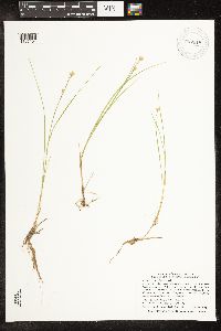 Rhynchospora alba (L.) Vahl 907018[1105104]Smith, Welby; et al. 310442008-07-24 United States, Minnesota, Saint Louis, Boundary Waters Canoe Area Wilderness / Superior National Forest. St. Louis County ... About 0.75 miles west of Fourtown Lake in the Boundary Waters Canoe Area Wilderness, Superior National Forest ... T65N R12W SW1/4 of SW1/4 of Sec 36. 065N 12W 36, 48.0669444 -91.8177778 |
MIN:Plants | 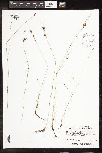 Rhynchospora fusca (L.) W.T. Aiton 463586[1105244]Carlson, Bruce Wypt 7722005-08-18 United States, Minnesota, Saint Louis, St. Louis County ... 5.3km east of Hoyt Lakes, 6.3km NW of Skibo, 0.6km NE of the railroad tracks ... T58N R14W NWSENE14;;058N;14W;14, 47.511163 -92.081465 |
MIN:Plants | 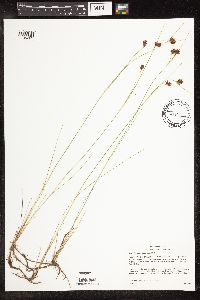 Rhynchospora fusca (L.) W.T. Aiton 437873[1105225]Gerdes, D. Lawson; et al. 6042004-08-11 United States, Minnesota, Lake, Superior National Forest. T60N R11W S13NWNESW Lake County ...Superior National Forest. Small unnamed lake, approximately 15.38 miles WNW of Slate Lake. South of Kelly Trail (FR 178).. 060N 11W 13, 47.683591 -91.665458 |
MIN:Plants | 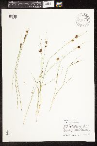 Rhynchospora fusca (L.) W.T. Aiton 914321[1105262]Scott, P. 31062008-08-06 United States, Minnesota, Cook, Cook County ... Gotter Lake, BWCAW. T65N R4W sec.31 NENWSE.;Boundary Waters Canoe Area Wilderness / Superior National Forest;065N;04W;31, 48.07034 -90.889498 |
MIN:Plants |  Rhynchospora fusca (L.) W.T. Aiton 454151[1105188]Lee, Michael MDL28082000-07-14 United States, Minnesota, Lake, Finland State Forest. Lake County ... two miles north-northeast of Finland, near pump house for old Air Force Base ... T57N R7W NW1/4 of SE1/4 of NW1/4 Sec. 9. 057N 07W 9, 47.436496 -91.225047 |
MIN:Plants |  Rhynchospora alba (L.) Vahl 507876[1105111]Suyker, A. AS-91992-09-05 United States, Minnesota, Itasca, Itasca County ... Found in Bog Lake ... at the Marcell Experimental Forest site.;Chippewa National Forest;;;, 47.512473 -93.485931 |
MIN:Plants |  Rhynchospora alba (L.) Vahl 690685[1105116]Shane, L. 76-31976-08-04 United States, Maine, Oxford, outlet margin of Black Pond, Sweden |
MIN:Plants |  Rhynchospora fusca (L.) W.T. Aiton 914787[1105259]Gerdes, Lynden; et al. 58312009-07-26 United States, Minnesota, Cook, Boundary Waters Canoe Area Wilderness / Superior National Forest. T64N R05W S10SWSWSWSW. Cook County. Superior National Forest. Boundary Waters Canoe Area Wilderness. Ecatasy Lake...southern end of lake.. 064N 05W 10, 48.035 -90.9611111 |
MIN:Plants |  Rhynchospora alba (L.) Vahl 438344[1105109]Whitfeld, T.J.S. 6352005-07-22 United States, Minnesota, Clearwater, Clearwater County...3/4 mile north of Sugar Bush Lake; 3/4 mile weest of Sugar Bush Lake Road...T143N R37W NENW3;White Earth Indian Reservation;143N;37W;03, 47.231197 -95.35013 |
MIN:Plants |  Rhynchospora fusca (L.) W.T. Aiton 918187[1105261]Anderson, Chel 21232009-08-02 United States, Minnesota, Cook, Cook County...north shore of Dent Lake...T63N R5W Sec. 5 NW1/4 of SE1/4;Boundary Waters Canoe Area Wilderness / Superior National Forest;063N;05W;05, 47.967897 -90.991359 |
MIN:Plants |  Rhynchospora colorata (L.) H. Pfeiffe 476515[1105182]Wagner, T. s.n.1981-04-22 United States, Texas, Kleberg, Kleberg Co. W side SPID at Padre Island National Seashore entrance;Padre Island National Seashore |
MIN:Plants |  Rhynchospora fusca (L.) W.T. Aiton 914813[1105260]Gerdes, Lynden; et al. 58092009-07-23 United States, Minnesota, Cook, Boundary Waters Canoe Area Wilderness / Superior National Forest. T65N R05W S36SENWNESE. Cook County. Superior National Forest. Boundary Waters Canoe Area Wilderness. Sandy point at far western end of Green Lake.. 065N 05W 36, 48.0691667 -90.9038889 |
MIN:Plants |  Rhynchospora fusca (L.) W.T. Aiton 918645[1105263]Holmstrom, R. 00712009-08-20 United States, Minnesota, Saint Louis, Superior National Forest. St. Louis County...Sturgeon River State Forest and Superior National Forest. Approximately 2 km southwest of Hwy 1 and Pfeiffer Lake State Forest Road (256) junction and about 1 km north of Pfeiffer Lake...T61N R17W S14 SW of SW. 061N 17W 14, 47.7588889 -92.4802778 |
MIN:Plants |  Rhynchospora fusca (L.) W.T. Aiton 432248[1105227]Gerdes, Lynden 48012003-07-24 United States, Minnesota, Lake, Superior National Forest. T60N R07W S33NWNE. Lake County...Superior National Forest. Approximately 6.41 miles ENE of Isabella, MN and 1.38 mile NW of Scott Lake. Bog pond 0.81 mile N of the Wanless Road.. 060N 07W 33, 47.63804 -91.224396 |
MIN:Plants | Rhynchospora capillacea Torrey 483928[1105160]Anderson, Craig United States, Minnesota, Pope, Detailed locality information protected. This is typically done to protect rare or threatened species localities. |
MIN:Plants |  Rhynchospora fusca (L.) W.T. Aiton 919967[1105265]Smith, Welby 258351995-08-12 United States, Minnesota, Cook, Boundary Waters Canoe Area Wilderness / Superior National Forest. Cook County...In the Boundary Waters Canoe Area Wilderness, Superior National Forest...east end of Duck Lake...T 63N R 5W SE1/4 of NE1/4 of Sec 11. 063N 05W 11, 47.9547222 -90.9183333 |
MIN:Plants |  Rhynchospora fusca (L.) W.T. Aiton 920911[1105253]Heep, Erin; et al. 2702010-06-22 United States, Minnesota, Saint Louis, St. Louis Co. ...unnamed pond in Boundary Waters Canoe Area Wilderness. On west end of pond...T63N R14W Section1 SE1/4;Boundary Waters Canoe Area Wilderness / Superior National Forest;063N;14W;01, 47.967985 -92.063426, 447m |
MIN:Plants |  Rhynchospora fusca (L.) W.T. Aiton 480929[1105248]Scott, P. 19752005-08-29 United States, Minnesota, Lake, LAKE CO ... Boulder Lake by portage to Ledge Lake, BWCAW. T64N R6W sec.20 NWSENE.;Boundary Waters Canoe Area Wilderness / Superior National Forest;064;06W;20, 48.014616 -91.12128 |
MIN:Plants |  Rhynchospora fusca (L.) W.T. Aiton 438246[1105245]Carlson, Bruce Wypt 6982005-07-28 United States, Minnesota, Saint Louis, Cloquet Valley State Forest. St. Louis County ...1.1km east of Berle Lake, 2.2km north of St. Louis Cnty Rd 49, 5.5km west of St. Louis Cnty Rd 4 ... T54N R14W NWSW 30. 054N 14W 30, 47.132715 -92.164232 |
MIN:Plants |  Rhynchospora alba (L.) Vahl 680181[1105115]Coffin, Barbara 3061976-07-12 United States, Wisconsin, Ashland, Presque Isle Point, Stockton Island, Apostle Islands National Lakeshore;Apostle Islands National Lakeshore;;;, 46.916326 -90.548792 |
MIN:Plants |  Rhynchospora fusca (L.) W.T. Aiton 488769[1105224]Gerdes, Lynden 48992004-08-09 United States, Minnesota, Lake, T60N R11W S36SESE. Lake County...Superior National Forest. Approximately 14.28 miles W of Isabella, MN.;Superior National Forest;060N;11W;36, 47.640097 -91.665677 |
MIN:Plants | Rhynchospora capillacea Torrey 909904[1105165]Gockman, Otto; et al. United States, Minnesota, Polk, Detailed locality information protected. This is typically done to protect rare or threatened species localities. |
MIN:Plants | Rhynchospora capillacea Torrey 909935[1105166]Gockman, Otto; et al. United States, Minnesota, Polk, Detailed locality information protected. This is typically done to protect rare or threatened species localities. |
MIN:Plants | 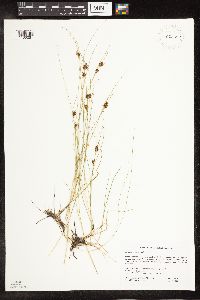 Rhynchospora fusca (L.) W.T. Aiton 925452[1105251]Gockman, Otto; Morantes, A. OTG000202009-07-19 United States, Minnesota, Lake, UTM: E622264 N5282398. NE1/4 of section;Superior National Forest;060N;08W;17, 47.6833333 -91.3708333 |
MIN:Plants | 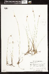 Rhynchospora fusca (L.) W.T. Aiton 923473[1105252]Holmstrom, R. 01202010-08-06 United States, Minnesota, Saint Louis, Approximately 4.2 km northwest of the Cty Rd 904 and Cty Rd 490 junction and about .6 km southeast of the se shoreline of Blueberry Lake. SE1/4 of SW1/4 of section;Bear Island State Forest;061N;13W;07, 47.7738889 -92.0447222 |
MIN:Plants | 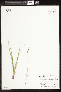 Rhynchospora fusca (L.) W.T. Aiton 926712[1105255]Anderson, Chel 21552010-09-09 United States, Minnesota, Cook, Ella Lake. UTM: 5303364 / 653457. NE1/4 of the SW1/4 of section;Boundary Waters Canoe Area Wilderness / Superior National Forest;062N;05W;10, 47.8652561 -90.948105 |
MIN:Plants | 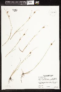 Rhynchospora fusca (L.) W.T. Aiton 923476[1105273]Gerdes, Lynden LBG62232010-09-15 United States, Minnesota, Cook, Small unnamed pond, approx. 8.25 miles N of Grand Marais, 1.6 miles W of Elbow Lake. SWNWNENE of section.;Superior National Forest;62N;01E;08, 47.8725 -90.3413889 |
MIN:Plants | 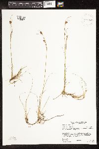 Rhynchospora fusca (L.) W.T. Aiton 923488[1105272]Gerdes, Lynden LBG62182010-09-14 United States, Minnesota, Cook, Approx. 7.25 miles N-NW of Grand Marais, .46 miles NW of Binagami Lake. NESW of section.;Superior National Forest;62N;01E;18, 47.8525 -90.3733333 |
MIN:Plants | 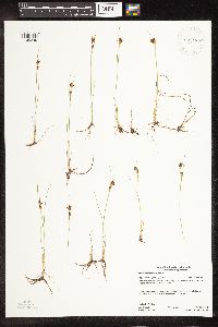 Rhynchospora fusca (L.) W.T. Aiton 923489[1105249]Gerdes, Lynden LBG60052010-06-14 United States, Minnesota, Cook, Approx. 11.42 miles N-NW of Lutsen, and .56 miles SE of Fleck Lake. SESWSESE of section.;Superior National Forest;62N;03W;31, 47.8036111 -90.7475 |
MIN:Plants | 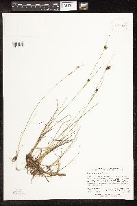 Rhynchospora fusca (L.) W.T. Aiton 923469[1105250]Holmstrom, R. RMH01172010-08-03 United States, Minnesota, Saint Louis, Approx. 5.1 km NW of Cty Rd 904 and Cty Rd 490 junction. SW of Square Lake about .4 km. SW of NW of section.;Bear Island State Forest;61N;14W;13, 47.7680556 -92.0683333 |
MIN:Plants | 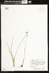 Rhynchospora fusca (L.) W.T. Aiton 926725[1105254]Anderson, Chel 21502010-09-09 United States, Minnesota, Cook, Ella Lake. UTM: 5303743/653739. SW1/4 of NE1/4 of section;Boundary Waters Canoe Area Wilderness / Superior National Forest;062N;05W;10, 47.8685964 -90.9442022 |
MIN:Plants |  Rhynchospora fusca (L.) W.T. Aiton 923466[1105203]Rowe, Erika; et al. ERR3542010-08-12 United States, Minnesota, Beltrami, 3 miles south of LOW/Beltrami County line; 6.35 miles west of Hwy 72; 13.5 miles NW of Waskish. NENE of section.;Beltrami Island State Forest / Red Lake Wildlife Management Area;156N;32W;24, 48.3218333 -94.692175 |
MIN:Plants |  Rhynchospora fusca (L.) W.T. Aiton 923467[1105202]Rowe, Erika; Aaseng, N. ERR3552010-08-11 United States, Minnesota, Lake of the Woods, 2 miles south of Rapid River Forest Road; 1 mile north of L.O.W./Beltrami County line; 20 miles NW of Waskish. NE of section.;Beltrami Island State Forest / Red Lake Indian Reservation;157N;33W;36, 48.3808139 -94.8299 |
MIN:Plants |  Rhynchospora fusca (L.) W.T. Aiton 928195[1105201]Gerdes, D. Lawson; Gerdes, Lynden 8842011-08-03 United States, Minnesota, Lake, Approx. 1.0 mi N of Comfort Lake. SENE of section.;Boundary Waters Canoe Area Wilderness / Superior National Forest;061N;07W;08, 47.7830556 -91.2383333 |
MIN:Plants |  Rhynchospora fusca (L.) W.T. Aiton 928651[1105268]Gerdes, Lynden; Smith, Welby 63622011-08-11 United States, Minnesota, Lake, Isabella Lake; Tiny island in the north central portion of lake. SENESWSW of section.;Boundary Waters Canoe Area Wilderness / Superior National Forest;062N;08W;25, 47.8183333 -91.2930556 |
MIN:Plants |  Rhynchospora fusca (L.) W.T. Aiton 928649[1105269]Gerdes, Lynden 64262011-09-06 United States, Minnesota, Lake, Approx. 0.41 mi N of Norway Lake. NENE of section.;Superior National Forest;061N;10W;03, 47.8019444 -91.5808333 |
MIN:Plants |  Rhynchospora fusca (L.) W.T. Aiton 928683[1105270]Anderson, Chel 21892011-08-12 United States, Minnesota, Lake, Ogishkemuncie Lake, SE-facing shore in northern reach of. UTM: 5327677 / 641590. NW1/4 of SE1/4 of section.;;065N;06W;13, 48.0866153 -91.0986742 |
MIN:Plants |  Rhynchospora fusca (L.) W.T. Aiton 928645[1105271]Rowe, Erika; et al. ERR4602011-08-17 United States, Minnesota, Beltrami, 7.5 mi W of Hwy 72; 13 NW of Waskish. NWSE of section.;Red Lake Peatland Scientific Natural Area;156N;32W;35, 48.2877472 -94.715025 |
Google Map
Google Maps is a web mapping service provided by Google that features a map that users can pan (by dragging the mouse) and zoom (by using the mouse wheel). Collection points are displayed as colored markers that when clicked on, displays the full information for that collection. When multiple species are queried (separated by semi-colons), different colored markers denote each individual species.