University of Minnesota
http://www.umn.edu/
612-625-5000
http://www.umn.edu/
612-625-5000
Minnesota Biodiversity Atlas
Bell Museum
Dataset: MIN-Plants
Taxa: Salicaceae
Search Criteria: excluding cultivated/captive occurrences
Bell Museum plants | |
 MIN:Plants | 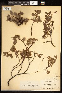 Salix arctica Pallas 95010[1206723]Collins, J.F. 61 Canada, Quebec |
MIN:Plants | 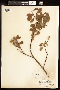 Salix arctica Pallas 95011[1206724]Waghorne, A.C. 3 Canada, Newfoundland and Labrador |
MIN:Plants | 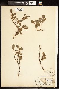 Salix arctica Pallas 95013[1206725]Bebb, M.S. s.n. Canada, Ontario |
MIN:Plants | 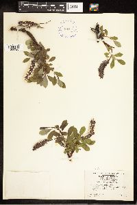 Salix arctica Pallas 398118[1206726]Harper, F. 2282 Canada, Nunavut |
MIN:Plants |  Salix arctica Pallas 538033[1206727]Abbe, E.C. 232 Canada, Newfoundland and Labrador |
MIN:Plants |  Salix arctica Pallas 95015[1206728]Waghorne, A.C. 63 Canada, Newfoundland and Labrador |
MIN:Plants |  Salix arctica Pallas 95014[1206729]Waghorne, A.C. 21 Canada, Newfoundland and Labrador |
MIN:Plants |  Salix arctica Pallas 948813[1226075]Eyerdam, W.J. 5220 United States, Alaska |
MIN:Plants |  Salix arctica Pallas 954993[1295268]Miller, Maynard M. 131948-00-00 United States, Alaska, Vicinity of Juneau, Juneau Icefield, station 2 |
MIN:Plants |  Salix arctica Pallas 954927[1295334]Miller, Maynard M. 1941948-00-00 United States, Alaska, St. Elias Mountains. Mt. Vancouver, site 11-4 |
MIN:Plants |  Salix arctica Pallas 954921[1295340]Miller, Maynard M. 2081948-00-00 United States, Alaska, St. Elias Mountains. Mt. Vancouver, vicinity of base camp, site GP13 |
MIN:Plants |  Salix interior Rowlee 499068[1091296]Capistrant, A. AMC12261998-04-30 United States, Minnesota, Carver, [no further data];;116N;23W;16, 44.855955 -93.591869 |
MIN:Plants |  Salix interior Rowlee 499319[1091294]Capistrant, A. AMC8561998-07-28 United States, Minnesota, Big Stone, [no further data];;123N;46W;22, 45.448927 -96.420592 |
MIN:Plants |  Salix interior Rowlee 462162[1091379]Smith, Welby 269651998-04-30 United States, Minnesota, Lac Qui Parle, Big Stone National Wildlife Refuge. Lac Qui Parle County ... Big Stone National Wildlife Refuge, about 3 miles south-southeast of Ortonville ... Minnesota River ... T 121N R 46W NW1/4 of SW1/4 of Sec 26. 121N 46W 26, 45.2591667 -96.4108333 |
MIN:Plants |  Salix interior Rowlee 919846[1091263]Smith, Welby 222461993-06-02 United States, Minnesota, Watonwan, Watline Wildlife Management Area. Watonwan County ... Watline State Wildlife Management Area, about 2 miles southwest of St. James ...T106N R32W NW1/4 of NE1/4 of Sec 34. 106N 32W 34, 43.9463889 -94.6686111 |
MIN:Plants |  Salix interior Rowlee 575755[1096985]Garton, C. 86531961-07-07 Canada, Ontario, Rainy River, Rainy River District...Rainy R. 4-1/2 mi. below Rainy R. Town, Wildland Reserve |
MIN:Plants | 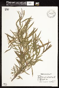 Salix interior Rowlee 918238[1091279]Smith, Welby 223611993-06-08 United States, Minnesota, Carver, about 5 miles west of Chanhassen. SE1/4 of NE1/4 of Sec;Carver Park Reserve County Park;116N;24W;11, 44.8716667 -93.6644444 |
MIN:Plants | 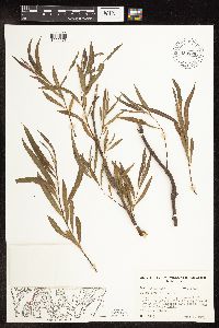 Salix interior Rowlee 653869[1096973]Sohmer, S. 75451973-06-06 United States, Wisconsin, Vernon, Co.: Vernon...Transect 8B, T14N R7W Sec. 6, Wis. Isl. 2;Upper Mississippi National Wildlife Refuge |
MIN:Plants | 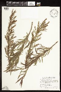 Salix interior Rowlee 508857[1091397]Smith, Welby 284392000-05-24 United States, Minnesota, Itasca, Chippewa National Forest. Itasca County ... Along Hwy 38, 0.5 mile south of jct with county road 49; about 5 miles south of Marcell ... T 58N T 26W SW1/4 of SE1/4 of Sec 4. 058N 26W 4, 47.5327778 -93.6466667 |
MIN:Plants | 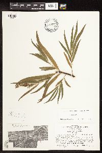 Salix interior Rowlee 699683[1096977]Ziegler, S.; Leykom, M. 20091975-07-24 United States, Wisconsin, La Crosse, Island 18; Mississippi River-mile #693.3; Island on E side of main channel;Upper Mississippi National Wildlife Refuge;014N;07W;32, 194m |
MIN:Plants | 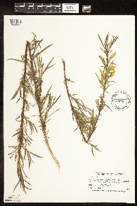 Salix interior Rowlee 478331[1091336]Smith, Welby 166021990-05-15 United States, Minnesota, Faribault, Fairbault [sic] County ... About 3.5 miles east-southeast of Huntley. On the floodplain of the Blue Earth River T 103N R 28W SW1/4 of SW1/4 of Sec 14. 103N 28W 14, 43.7194444 -94.1655556 |
MIN:Plants | 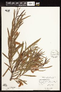 Salix interior Rowlee 575751[1096984]Garton, C. 87741961-07-17 Canada, Ontario, Rainy River, Rainy River District...Sable I, S. end of Lake of the Woods |
MIN:Plants | 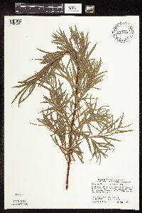 Salix interior Rowlee 472005[1091285]Smith, Welby 275861998-09-11 United States, Minnesota, Yellow Medicine, Yellow Medicine County ... About 8 miles west-southwest of Canby ... T114N R46W SW1/4 of SW1/4 of Sec 5;;114N;46W;05, 44.7044449 -96.4361115 |
MIN:Plants | 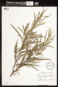 Salix interior Rowlee 915956[1091319]Smith, Welby 251431994-08-17 United States, Minnesota, Koochiching, Koochiching County...Along the Rainy River, about 12 miles west of Loman...T 160N R 26W NW1/4 of SE1/4 of Sec 36;;160N;26W;36, 48.6302778 -93.9122222 |
MIN:Plants |  Salix interior Rowlee 489222[1091298]Smith, Welby 269681998-04-30 United States, Minnesota, Traverse, Horman Wildlife Management Area. Traverse County ... Horman National Waterfowl Production Area, about 14 miles northeast of Browns Valley (town) ... T 126N R 47W NE1/4 of NE1/4 of Sec 33. 126N 47W 33, 45.6850014 -96.5763855 |
MIN:Plants |  Salix interior Rowlee 95849[1096969]Nelson, Aven; et al. 58661899-07-14 United States, Wyoming, Park, Yellowstone National Park...Soda Butte Creek;Yellowstone National Park |
MIN:Plants |  Salix interior Rowlee 478267[1091278]Smith, Welby 260401996-05-25 United States, Minnesota, Winona, Whitewater Wildlife Management Area. Winona County ... Whitewater State Wildlife Management Area, about 8 miles S-SW of Weaver ... along the Whitewater River ... T 108N R 10W SW1/4 of NE1/4 of Sec 27. 108N 10W 27, 44.1297226 -92.0077744 |
MIN:Plants |  Salix interior Rowlee 273981[1096983]Moore, John W. 4191924-07-00 United States, South Dakota, Custer, Wind Cave National Park, 43.580095 -103.439479 |
MIN:Plants |  Salix interior Rowlee 489425[1091291]Smith, Welby 269791998-05-04 United States, Minnesota, Polk, Winger Wildlife Area. Polk County ... Winger National Waterfowl Production Area, about 2 miles north-northeast of Winger (town) ... T147N R42W SE1/4 of SE1/4 of Sec 11. 147N 42W 11, 47.5577774 -95.964447 |
MIN:Plants |  Salix interior Rowlee 916869[1091264]Smith, Welby 224931993-06-18 United States, Minnesota, Douglas, about 6 miles north of Alexandria. SE1/4 of SW1/4 of section;Lake Carlos State Park;129N;37W;09, 45.9958333 -95.3469444 |
MIN:Plants |  Salix interior Rowlee 598811[1096981]Tryon, R. 28441936-09-07 United States, Indiana, Porter, Indiana Dunes State Park;Indiana Dunes National Lakeshore;;;, 41.66306 -87.03694 |
MIN:Plants |  Salix interior Rowlee 653858[1096975]Sohmer, S. 75001973-06-06 United States, Wisconsin, Vernon, Co.: Vernon...Transect 8B, T14N R4W Sec. 6, 1st Isl. on trnsct E of Channel;Upper Mississippi National Wildlife Refuge |
MIN:Plants |  Salix interior Rowlee 908383[1091297]Gerdes, Lynden 51192006-05-24 United States, Minnesota, Itasca, George Washington State Forest. T59N R25W S33SENW. Itasca County, MN. George Washington State Forest. Approximately 8.32 miles SE of Marcell, MN and 0.28 miles WNW of Three Island Lake.. 059N 25W 33, 47.552538 -93.52503 |
MIN:Plants |  Salix interior Rowlee 488979[1091282]Smith, Welby 155671989-07-04 United States, Minnesota, Freeborn, Halls Lake Wildlife Management Area. Freeborn County...Halls Lake National Waterfowl Production Area, about 3.5 miles NE of Alden...NW1/4 NE1/4 section 30, T103N R22W.. 103N 22W 30, 43.694869 -93.518532 |
MIN:Plants |  Salix interior Rowlee 461898[1091284]Smith, Welby 266621997-06-27 United States, Minnesota, Washington, William O'Brien State Park. Washington County ... William O'Brien State Park. In the St. Croix Valley, about 1.5 miles north of Marine ... T32N R19W SW1/4 of SW1/4 of Sec 30. 032N 19W 30, 45.2249985 -92.7600021 |
MIN:Plants |  Salix interior Rowlee 653843[1096970]Sohmer, S. 74571973-06-06 United States, Wisconsin, Vernon, Co.: Vernon...Transect 8B, T14N R4W Sec. 6, 1st Isl. on trnsct E of Channel;Upper Mississippi National Wildlife Refuge |
MIN:Plants | 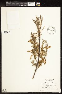 Salix interior Rowlee 585837[1096982]Porter, C.; et al. 93111963-06-20 United States, Wyoming, Teton, Teton County. Grand Teton National Park...along Pacific Creek near Moran.;Grand Teton National Park, 2042m |
MIN:Plants | 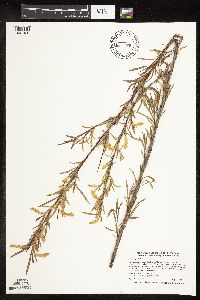 Salix interior Rowlee 462155[1091426]Smith, Welby 270401998-05-12 United States, Minnesota, Itasca, Itasca County ... Big Fork River, just east of the town of Big Fork ... T 61N R 26W NE1/4 of NE1/4 of Sec 27;;061N;26W;27, 47.7458344 -93.6555557 |
MIN:Plants | 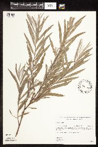 Salix interior Rowlee 489526[1091473]Gerdes, Lynden 38061999-08-13 United States, Minnesota, Cook, Superior National Forest. T65N R04W S26NESE Cook County ...Superior National Forest. Gravel/sand pit approximately .25 mile south east of the Gunflint Trail (Cty. 12) and Cross River intersection. Pit is on the south side of the Gunflint Trail.. 065N 04W 26, 48.08284 -90.803294 |
MIN:Plants | 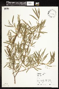 Salix interior Rowlee 616321[1091280]Juhnke, C. 218 CMJ FRO1999-05-14 United States, Minnesota, Goodhue, Frontenac State Park Goodhue County ... edge of woods south of interpretive area ... T112N R13W NESENE 3;Frontenac State Park;112N;13W;3, 44.534992 -92.358902 |
MIN:Plants | 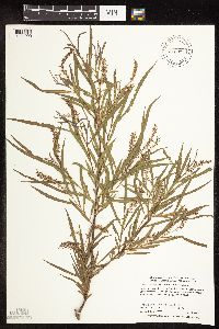 Salix interior Rowlee 488259[1091290]Smith, Welby 272521998-06-16 United States, Minnesota, Carlton, Carlton County ... At the west end of Hanging Horn Lake ... T 46N R 19W NW1/4 of SE1/4 of Sec 11;;046N;19W;11, 46.4805565 -92.7041702 |
MIN:Plants | 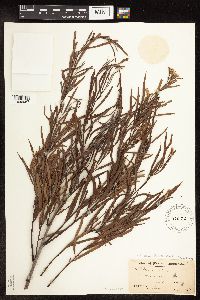 Salix interior Rowlee 96023[1096967]Moyer, Lycurgus 11811906-06-26 United States, South Dakota, Roberts, Manhattan Island, Big Stone Lake |
MIN:Plants | 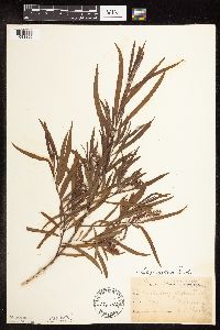 Salix interior Rowlee 180042[1091396]Sheldon, Edmund S6391891-06-00 United States, Minnesota, Waseca, Waseca.;;107N;22W;, 44.077741 -93.507443 |
MIN:Plants | 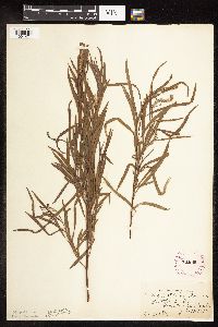 Salix interior Rowlee 261965[1091471]Cratty, R. 71927-07-27 United States, Minnesota, Martin, Tuttle Lake.;;101N;31W;, 43.5333 -94.6 |
MIN:Plants | 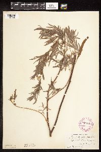 Salix interior Rowlee 264925[1091329]Pammel, L. s.n.1927-08-28 United States, Minnesota, Freeborn, Glenville;;N;;, 43.5714 -93.279773 |
MIN:Plants | 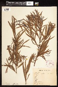 Salix interior Rowlee 265662[1091367]Anonymous 101912-07-29 United States, Minnesota, Kandiyohi, Willmar.;;119N;35W;, 45.121908 -95.043342 |
MIN:Plants | 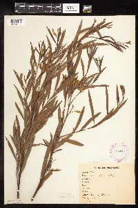 Salix interior Rowlee 267074[1091339]Stevenson, J. 1391912-07-11 United States, Minnesota, Beltrami, Bemidji;;N;;, 47.536341 -94.82277 |
MIN:Plants | 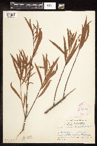 Salix interior Rowlee 276011[1091368]Grant, Martin 33631929-09-18 United States, Minnesota, Clearwater, Bank of the Mississippi [River]. NE1/4 SE1/4 T144N, R36W, Sec. 34.;Itasca State Park;144N;36W;34, 47.244749 -95.214843 |
MIN:Plants |  Salix interior Rowlee 332100[1091312]Moyle, J.; et al. 17481934-08-14 United States, Minnesota, Becker, Island Lake.;;140N;38W;, 46.929746 -95.5318 |
MIN:Plants |  Salix interior Rowlee 338151[1091446]Rosendahl, C.; Moyle, J. 22501936-07-18 United States, Minnesota, Beltrami, 8 mi. N of Waskish, near Lookout Tower.;;N;;, 48.279676 -94.508942 |
MIN:Plants |  Salix interior Rowlee 337576[1091479]Lakela, Olga 15771936-07-29 United States, Minnesota, Saint Louis, Sec. 19, Duluth. [other collections indicates this is in T49N R13W, Minnesota Point];Minnesota Point;049N;13W;19, 46.7833 -92.1 |
MIN:Plants |  Salix interior Rowlee 337638[1091484]Lakela, Olga 13761936-05-30 United States, Minnesota, Saint Louis, NE of the old lighthouse ruins, Sec. 20, U.S. Govt. Property, Duluth.;Minnesota Point;049N;13W;20, 46.7833 -92.1 |
MIN:Plants |  Salix interior Rowlee 348575[1091365]Cook, E. 811938-06-21 United States, Minnesota, Hennepin, River bank near tennis courts, University Campus, Minneapolis.;;N;;, 44.973408 -93.227959 |
MIN:Plants |  Salix interior Rowlee 348993[1091474]Nielsen, E. 29241934-08-16 United States, Minnesota, Lincoln, 1/4 mi. N of the inlet to Dead Coon Lake.;;N;;, 44.365826 -96.096396 |
MIN:Plants |  Salix interior Rowlee 349733[1091452]Hedman, H. 51938-06-00 United States, Minnesota, Hennepin, E shore of Tonka Bay, Lake Minnetonka.;;N;;, 44.90931 -93.592811 |
MIN:Plants |  Salix interior Rowlee 352705[1091467]Seim, A. 151937-07-03 United States, Minnesota, Ramsey, E edge of r.r. tracks, N of U.M.C.A, N of University Ave, Midway dist, St. Paul. Ramsey Co.;;029N;23W;, 44.958984 -93.175449 |
MIN:Plants |  Salix interior Rowlee 352706[1091317]Jukkola, E. 401937-06-24 United States, Minnesota, Hennepin, East River Road S of the Botany Building, Minneapolis.;;N;;, 44.967852 -93.225041 |
MIN:Plants |  Salix interior Rowlee 353415[1091307]Moyle, J. 5091931-07-09 United States, Minnesota, Clearwater, Shore of Lake Itasca. SW1/4 NW1/4 Sec. 2, T143N, R36W.;Itasca State Park;143N;36W;2, 47.231974 -95.201528 |
MIN:Plants |  Salix interior Rowlee 354292[1091477]Moyle, J. 13641934-07-14 United States, Minnesota, Becker, Ponsford Prairie.;;N;;, 46.96996 -95.383919 |
MIN:Plants |  Salix interior Rowlee 358519[1091431]Buell, Murray 17921939-06-25 United States, Minnesota, Beltrami, S shore of Red Lake, W of Ponemah, Red Lake Ind. Res.;Red Lake Indian Reservation;N;;, 47.876346 -95.01694 |
MIN:Plants | 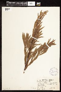 Salix interior Rowlee 360724[1091302]Rosendahl, C.; et al. 70701938-09-04 United States, Minnesota, Marshall, near rr track; 2 mi S of Holt;;;;, 48.26297 -96.192531 |
MIN:Plants | 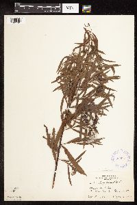 Salix interior Rowlee 360931[1091345]Horton, E. s.n.1936-08-12 United States, Minnesota, Saint Louis, Minnesota Point;Minnesota Point;049N;13W;18, 46.72833 -92.04778 |
MIN:Plants | 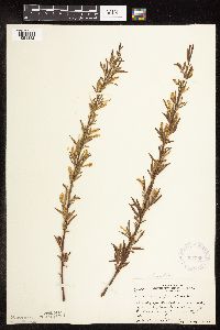 Salix interior Rowlee 367586[1091332]Moore, John; et al. 124161940-05-17 United States, Minnesota, Freeborn, NW1/4 Sec. 6, Manchester Twp. ...creek. Freeborn Co.;;103N;22W;06, 43.75131 -93.524322 |
MIN:Plants | 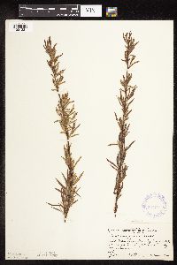 Salix interior Rowlee 367774[1091381]Moore, John; et al. 124411940-05-17 United States, Minnesota, Mower, Red Cedar River floodplain, SW1/4 Sec. 17, Lyle Twp. Mower Co.;;101N;18W;17, 43.547923 -93.013864 |
MIN:Plants |  Salix interior Rowlee 367794[1091331]Moore, John; et al. 125511940-05-25 United States, Minnesota, Wright, W edge of the town of Maple Lake. Wright Co.;;;;, 45.230296 -94.013178 |
MIN:Plants |  Salix interior Rowlee 367905[1091346]Moore, John; et al. 127811940-05-26 United States, Minnesota, Otter Tail, SE1/4 Sec 8, Effington Twp. Otter Tail Co.;;131N;38W;08, 46.173488 -95.491061 |
MIN:Plants |  Salix interior Rowlee 369690[1091356]Moore, John; et al. 139941941-05-24 United States, Minnesota, Pine, W shore of Cross Lake; Pine City. Pine Co.;;039N;21W;, 45.8394 -92.937708 |
MIN:Plants |  Salix interior Rowlee 369810[1091330]Moore, John; et al. 145431941-06-15 United States, Minnesota, Red Lake, Clearwater River; 1/2 mi. N of Plummer, on Hwy. 59. Red Lake Co.;;151N;42W;, 47.924071 -96.042608 |
MIN:Plants |  Salix interior Rowlee 370227[1091366]Moore, John; et al. 141841941-06-10 United States, Minnesota, Wilkin, W bank of the Rabbit River, SW1/4 Sec. 30, Champion Twp. Wilkin Co.;;130N;45W;30, 46.112016 -96.560908 |
MIN:Plants |  Salix interior Rowlee 370257[1091472]Moore, John; et al. 138231941-05-10 United States, Minnesota, Olmsted, Beside the r.r. tracks, 3/4 mi. SE of Marion. Olmsted Co.;;;;, 43.934657 -92.336956 |
MIN:Plants |  Salix interior Rowlee 381461[1091468]Moore, John; et al. 154541942-06-20 United States, Minnesota, Dodge, By roadside above the river, 1 mi. E [W?] of Berne, Concord Twp. Dodge Co.;;108N;17W;, 44.163573 -92.75917 |
MIN:Plants |  Salix interior Rowlee 381577[1091470]Moore, John; Harden, P. 142981942-05-16 United States, Minnesota, Pine, Crooked Creek, 18 mi. E of Hinckley.;;N;;, 45.98333 -92.51528 |
MIN:Plants | 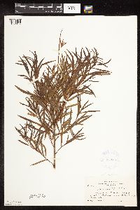 Salix interior Rowlee 381677[1091469]Moore, John 155611942-06-28 United States, Minnesota, Polk, 4 1/2 mi. W of Fertile on Beltrami Road.;;N;;, 47.536036 -96.376814 |
MIN:Plants | 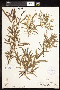 Salix interior Rowlee 383363[1091432]Moore, John 157221943-06-04 United States, Minnesota, Rice, Along the Straight River, Faribault.;;;;, 44.294964 -93.268827 |
MIN:Plants | 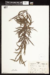 Salix interior Rowlee 386027[1091373]Moyle, J. 50531945-08-31 United States, Minnesota, Fillmore, Fillmore Co. Near Whalen. Along the Root River.;;103N;09W;, 43.732186 -91.926543 |
MIN:Plants | 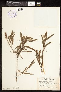 Salix interior Rowlee 392949[1091476]Lakela, Olga 64701946-06-26 United States, Minnesota, Saint Louis, Sandbar Island in Duluth Harbor, Duluth.;;N;;, 46.7833 -92.1 |
MIN:Plants |  Salix interior Rowlee 396787[1091360]Stevens, O. s.n.1947-07-11 United States, Minnesota, Clay, [no further data];Buffalo River State Park;139N;46W;10, 46.863699 -96.472855 |
MIN:Plants |  Salix interior Rowlee 396805[1091340]Stevens, O. 10511948-05-23 United States, Minnesota, Clay, near Buffalo State Park, Muskoda [historic RR station near Hawley];;139N;45W;00, 46.86404 -96.46709 |
MIN:Plants |  Salix interior Rowlee 412492[1091487]Moore, John; Moore, Marjorie 112141939-07-27 United States, Minnesota, Lake of the Woods, W bank of Harrison River, 1 mi. up from the mouth, Northwest Angle.;Northwest Angle;N;;, 49.095685 -94.94163 |
MIN:Plants |  Salix interior Rowlee 412882[1091486]Moore, John; Moore, Marjorie 114541939-08-05 United States, Minnesota, Roseau, Along the W shore of Muskeg Bay, N of Warroad.;;N;;, 48.948125 -95.315777 |
MIN:Plants | 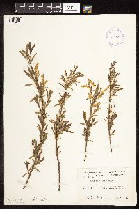 Salix interior Rowlee 413166[1091485]Moore, John; Moore, Marjorie 106581939-05-07 United States, Minnesota, Dakota, Minnesota River flats, 1 mi. S of Mendota.;Fort Snelling State Park;028N;23W;, 44.873018 -93.177778 |
MIN:Plants | 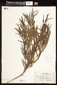 Salix interior Rowlee 420054[1091461]Lakela, Olga 112321950-08-08 United States, Minnesota, Saint Louis, Savanna River bank at Floodwood.;;051N;20W;, 46.92911 -92.919648 |
MIN:Plants | 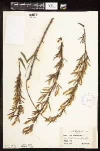 Salix interior Rowlee 420654[1091283]Lakela, Olga 101881950-06-04 United States, Minnesota, Saint Louis, Mission Creek terrace at Fond du Lac, Duluth.;;N;;, 46.7833 -92.1 |
MIN:Plants | 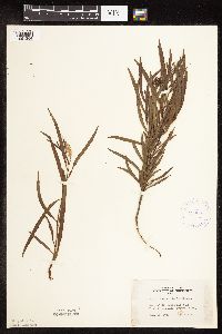 Salix interior Rowlee 420691[1091304]Lakela, Olga 113701950-08-14 United States, Minnesota, Saint Louis, St. Louis County ... Bank of the St. Louis River at Fond du Lac Park.;;048N;15W;, 46.659664 -92.273248 |
MIN:Plants | 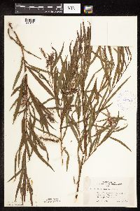 Salix interior Rowlee 421301[1091354]Lakela, Olga 111751950-08-08 United States, Minnesota, Saint Louis, Bank of the Savanna River, W of Floodwood, Hwy. 29.;;051N;20W;, 46.9167 -92.9167 |
MIN:Plants | 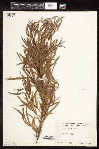 Salix interior Rowlee 425986[1091303]Moyle, J. s.n.1951-08-17 United States, Minnesota, Roseau, Noracres Swamp;;N;;, 48.777189 -95.819519 |
MIN:Plants | 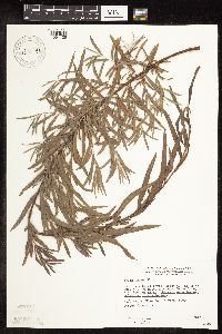 Salix interior Rowlee 430767[1091425]Wheeler, Gerald 112121988-07-19 United States, Minnesota, Big Stone, Barry Lake Wildlife Management Area. Big Stone Co.; Ca. 1 mi. NW of Barry, about 0.7 mi. E of Rte. 57; Barry Lake; W1/2 SE1/4 NE1/4 Sec. 8 T124N R47W (Toqua Township). 124N 47W 8, 45.567133 -96.579895 |
MIN:Plants | 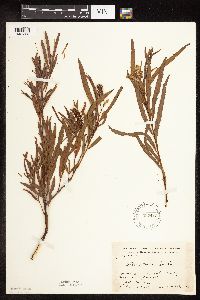 Salix interior Rowlee 437418[1091353]Moore, John; Hall, Robert 165531944-06-13 United States, Minnesota, Redwood, 1 mi. E of Revere on Hwy. 14. Redwood Co.;;109N;37W;, 44.223844 -95.344235 |
MIN:Plants | 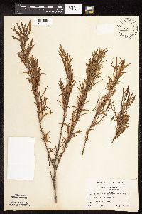 Salix interior Rowlee 440080[1091393]Spencer, O. s.n.1937-05-20 United States, Minnesota, Anoka, at Moore Lake, Minneapolis;;030N;24W;, 45.077013 -93.252399 |
MIN:Plants | 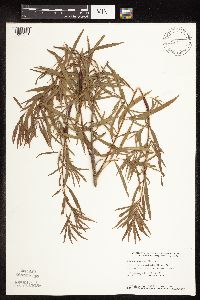 Salix interior Rowlee 440123[1091271]Smith, Welby 164111989-09-06 United States, Minnesota, Benton, Benton Co. On the E bank of the Mississippi River in Rice; NE1/4 NE1/4 sec.36, T38N R32W;;038N;32W;36, 45.748333 -94.2600021 |
MIN:Plants | 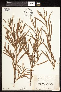 Salix interior Rowlee 441975[1091488]Moore, John; Huff, N. 184281945-10-19 United States, Minnesota, Rock, 3 1/2 mi. SW of Jasper.;;N;;, 43.814114 -96.448356 |
MIN:Plants | 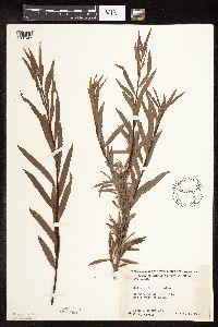 Salix interior Rowlee 441993[1091465]Moore, John; et al. 182281945-09-05 United States, Minnesota, Kittson, Kittson County...1 mi. NW of Halma.;;;;, 48.661089 -96.60032 |
MIN:Plants | 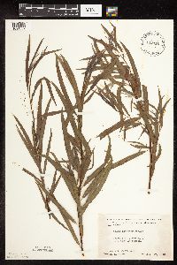 Salix interior Rowlee 442116[1091387]Moore, John; Huff, N. 190991946-08-17 United States, Minnesota, Swift, City park at Benson. Swift Co.;;121N;39W;, 45.31496 -95.600035 |
MIN:Plants | 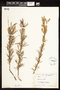 Salix interior Rowlee 444669[1091430]Moore, John; Huff, N. 195751947-06-14 United States, Minnesota, Itasca, 5 mi. S of Grand Rapids.;;N;;, 47.164788 -93.530214 |
MIN:Plants | 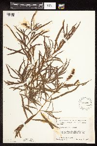 Salix interior Rowlee 445160[1091375]Moore, John; Huff, N. 197041947-08-07 United States, Minnesota, Morrison, Along the Crow Wing River, 6 mi. E of Hwy. 10.;;N;;, 46.066263 -94.340869 |
MIN:Plants | 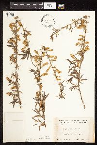 Salix interior Rowlee 446062[1091456]Moore, John 171721945-06-18 United States, Minnesota, Kittson, 1 mi. SE of Noyes.;;N;;, 48.968829 -97.2 |
MIN:Plants | 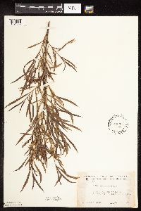 Salix interior Rowlee 446074[1091352]Moore, John 172191945-06-17 United States, Minnesota, Pennington, 5 mi. W of Thief River Falls.;;N;;, 48.153843 -96.187815 |
MIN:Plants | 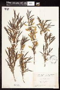 Salix interior Rowlee 446144[1091384]Moore, John; et al. 172871945-06-18 United States, Minnesota, Roseau, Roseau County...8 mi. S of Roseau.;;;;, 48.731585 -95.756243 |
MIN:Plants | 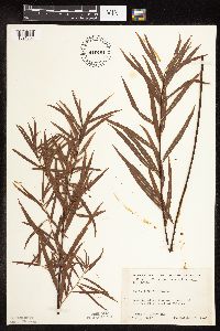 Salix interior Rowlee 446491[1091308]Moore, John; Huff, N. 183451945-10-06 United States, Minnesota, Mille Lacs, Along the W branch of the Rum River, W of Milaca.;;N;;, 45.644935 -93.557162 |
MIN:Plants | 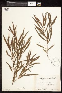 Salix interior Rowlee 448895[1091447]Moore, John; Hall, Robert 167241944-08-01 United States, Minnesota, Aitkin, 10 mi. NE of Aitkin.;;N;;, 46.664275 -93.531915 |
Google Map
Google Maps is a web mapping service provided by Google that features a map that users can pan (by dragging the mouse) and zoom (by using the mouse wheel). Collection points are displayed as colored markers that when clicked on, displays the full information for that collection. When multiple species are queried (separated by semi-colons), different colored markers denote each individual species.