University of Minnesota
http://www.umn.edu/
612-625-5000
http://www.umn.edu/
612-625-5000
Minnesota Biodiversity Atlas
Bell Museum
Dataset: MIN-Plants
Taxa: Saxifragaceae
Search Criteria: excluding cultivated/captive occurrences
Bell Museum plants | |
 MIN:Plants | 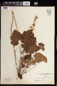 Heuchera richardsonii R. Brown 961493[1334961]Kramer, Leona 1927-00-00 United States, Minnesota, Mower |
MIN:Plants | 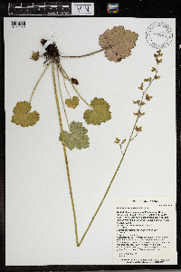 Heuchera richardsonii R. Brown 966303[1359142]T. J. S. Whitfeld 24972020-06-03 United States, Minnesota, Washington, Lost Valley Prairie Scientific and Natural Area, 2 miles east north east of intersection of State Highway 95 and 110th Street, at dead-end of Nyberg Avenue South, 44.798227 -92.825035, 279m |
MIN:Plants | 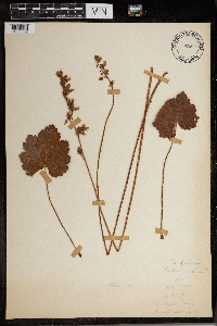 Heuchera richardsonii R. Brown 965896[1356652] 1948-06-17 United States, Minnesota, Anderson's Farm |
MIN:Plants | 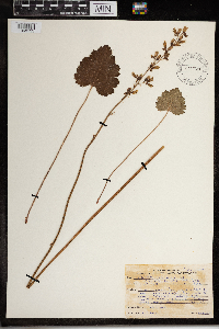 Heuchera richardsonii R. Brown 967606[1368133]Drew, L.A. s.n.1970-06-20 United States, Minnesota, Polk, 1.5 miles S Fertile; Fertile Dunes; T147N R44W sec. 32 W 1/2 NE 1/4, 47.510705 -96.288072 |
MIN:Plants | 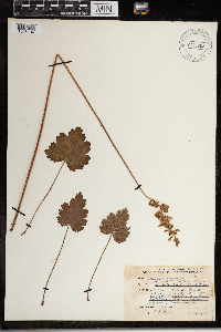 Heuchera richardsonii R. Brown 967605[1368134]Drew, L.A. s.n.1969-07-02 United States, Minnesota, Mahnomen, 8 miles E Mahnomen; T144N R40W sec. 5 NW NW 1/4; 47.322621 -95.781917, 47.322621 -95.781917 |
MIN:Plants | 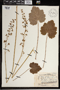 Heuchera richardsonii R. Brown 967604[1368135]Drew, L.A. s.n.1969-06-16 United States, Minnesota, Winona, Whitewater State Park; T107N %10W sec. 20 NE SE 1/4, 44.058451 -92.047229 |
MIN:Plants | 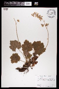 Heuchera richardsonii R. Brown 969656[1371245]Dunevitz, Hannah L. 7571992-06-10 United States, Minnesota, Wabasha, North-facing bluff on the south edge of Wabasha, just west of Highway 61., 44.43 -92.26 |
MIN:Plants | Heuchera richardsonii R. Brown []Timothy J. S. Whitfeld 37222023-07-07 United States, Minnesota, Marshall, Huntley Management Area, 0.5 miles northwest of right angle turn of 130th Avenue NE, 48.45447 -96.19626, 354m |
MIN:Plants | Heuchera richardsonii R. Brown []Kerstin Griffin 451964-05-29 United States, Minnesota, Scott, 4 miles southwest Shakopee along Highway 169. Old pasture. Found on dry ridge with sandy and gravelly soil., 44.757043 -93.584623 |
MIN:Plants | 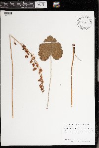 Heuchera richardsonii R. Brown 976397[1403111]Dunevitz, Hannah L. 5791991-06-24 United States, Minnesota, Winona, Steep southwest-facing bluff above Highway 61, about 1/2 mile north of County Road 3 and about 2 1/2 miles southeast of Lamoille., 43.98 -91.43 |
MIN:Plants | Suksdorfia ranunculifolia (Hooker) Engler 125150[]Piper, C. 20331895-08-00 United States, Washington, Pierce, Mt. Rainier;Mount Rainier National Park, 1981m |
MIN:Plants | Suksdorfia ranunculifolia (Hooker) Engler 657602[]Anderson, H.; et al. 1341963-07-24 United States, Montana, Glacier, Glacier National Park: Grinnell Glacier Trail;Glacier National Park |
MIN:Plants | Saxifraga mertensiana Bongard 380763[]Ownbey, Marion; et al. 22471940-07-15 United States, Washington, Jefferson, Jefferson Co. ...along Graves Creek at mouth of Success Creek, Olympic National Park.;Olympic National Park |
MIN:Plants | Saxifraga mertensiana Bongard 579264[]Kaul, R. 16561960-07-07 United States, Montana, Glacier National Park...Reynold's cirque;Glacier National Park |
MIN:Plants | Saxifraga mertensiana Bongard 124895[]Elmer, A.D.E. 26431900-07-00 United States, Washington, Clallam, Olympic Mts. [Olympic National Park], 47.83 -123.83 |
MIN:Plants | Saxifraga mertensiana Bongard 124894[]Conard, Henry 3901902-06-21 United States, Washington, Grays Harbor, Quiniault [sic] Falls;Olympic National Park;;;, 47.468093 -123.84669 |
MIN:Plants | Mitella nuda L. 913676[]Smith, Welby 243081994-07-02 United States, Minnesota, Polk, Polk County... Along the south side of the Sand Hill River, about 1.5 miles west of Fertile... T147N R44W NE1/4 of SW1/4 of Sec 19. 147N 44W 19, 47.5325 -96.3116667 |
MIN:Plants | Mitella nuda L. 490140[]Stevens, O. 12351951-05-27 United States, North Dakota, Pembina, Tonguw River. Akra (Pembina Co.) |
MIN:Plants | Mitella nuda L. 909970[]Smith, Welby 312022008-08-19 United States, Minnesota, Beltrami, Red Lake State Forest. Beltrami County...along the Tamarac River, near where it enters Upper Red Lake in Waskish...T 154N R 30W NW1/4 of NW1/4 of Sec 9. 154N 30W 9, 48.1755556 -94.5063889 |
MIN:Plants | Mitella nuda L. 472918[]Lee, Michael MDL16321997-05-20 United States, Minnesota, Stearns, Stearns Co.; on north side of Interstate 94 three miles northwest of Avon; T125N R30W SE1/4 of NW1/4 Sec. 19, NW1/4 etc.;;125N;30W;19, 45.622369 -94.500508 |
MIN:Plants | Mitella nuda L. 123310[]Wheeler, William 7611900-08-00 United States, Michigan, Keweenaw, Tobin's Harbor, Isle Royale;Isle Royale National Park |
MIN:Plants | Mitella nuda L. 456505[]Lee, Michael MDL21161998-06-09 United States, Minnesota, Benton, Benton Co.; Sartell Swamp, along Little Rock Creek 3-1/3 miles northeast of Rice; T38N R31W NE1/4 of SW1/4 Sec. 10;;038N;31W;10, 45.793965 -94.189626 |
MIN:Plants | Mitella nuda L. 575273[]Garton, C. 89571961-07-25 Canada, Ontario, Rainy River, Rainy River District...10 mi. N. of Rainy R. Town, on H. 600, Wildland Reserve |
MIN:Plants | Mitella nuda L. 355138[]Sandberg, John s.n.1889-06-00 United States, Michigan, Keweenaw, Isle Royal [sic];Isle Royale National Park |
MIN:Plants | Mitella nuda L. 123323[]Rosendahl, C. 12421903-05-23 United States, Minnesota, Hennepin, Near Purgatory Swamp.;;N;;, 44.86429 -93.499344 |
MIN:Plants | Mitella nuda L. 123324[]Rosendahl, C. R27281914-05-20 United States, Minnesota, Hennepin, 2 mi. W of Cedar Lake. [other Rosendahl collections indicated this was in Minneapolis];;118N;21W;, 44.959987 -93.3672 |
MIN:Plants | Mitella nuda L. 123325[]Butters, F.; et al. R27571914-06-11 United States, Minnesota, Morrison, N of Randall.;;130N;30W;06, 46.091077 -94.50362 |
MIN:Plants | Mitella nuda L. 123326[]Rosendahl, C. 37341918-08-23 United States, Minnesota, Clearwater, Floating Bog Bay, Itasca State Park.;Itasca State Park;143N;36W;, 47.197458 -95.201964 |
MIN:Plants | Mitella nuda L. 123327[]Rosendahl, C. 21461909-06-22 United States, Minnesota, Hennepin, Deephaven;;N;;, 44.928253 -93.524063 |
MIN:Plants | Mitella nuda L. 123328[]Rosendahl, C. 36821918-08-17 United States, Minnesota, Hubbard, Near La Salle Springs, Itasca State Park.;Itasca State Park;143N;35W;, 47.19592 -95.107697 |
MIN:Plants | Mitella nuda L. 123329[]Butters, F. s.n.1918-10-05 United States, Minnesota, Chisago, Taylor's Falls;;034N;19W;, 45.401187 -92.651766 |
MIN:Plants | Mitella nuda L. 484619[]Lee, Michael MDL24621998-09-10 United States, Minnesota, Mille Lacs, Mille Lacs Kathio State Park. Mille Lacs Co.; Mille Lacs - Kathio State Park. Along the Rum River 3-1/2 miles northwest of Onamia; T42N R27W W1/2 of NE1/4 Sec. 21, E1/2 of NW1/4 Sec. 21. 042N 27W 21, 46.160194 -93.757743 |
MIN:Plants | Mitella nuda L. 123330[]Sandberg, John 18491885-06-00 United States, Minnesota, Lake, Agate Bay;North Shore;052N;11W;01, 47.01954 -91.67918 |
MIN:Plants | Mitella nuda L. 123331[]Bergman, H. 31021914-08-26 United States, Minnesota, Hubbard, Benedict;Paul Bunyan State Forest;143N;32W;35, 47.15729 -94.6957 |
MIN:Plants | Mitella nuda L. 123332[]Rosendahl, C. 24731910-05-30 United States, Minnesota, Hennepin, Deephaven Swamp.;;N;;, 44.928253 -93.524063 |
MIN:Plants | Mitella nuda L. 123333[]Anderson, A. A6311893-07-00 United States, Minnesota, Cass, Gull Lake;;N;;, 46.446379 -94.35099 |
MIN:Plants | Mitella nuda L. 123334[]Arthur, J.; et al. B881886-07-19 United States, Minnesota, Saint Louis, Vermilion Lake;;;;, 47.891581 -92.366824 |
MIN:Plants | Mitella nuda L. 123335[]Herrick, C. s.n.1878-06-00 United States, Minnesota, Hennepin, Minneapolis;;N;;, 44.979965 -93.263836 |
MIN:Plants | Mitella nuda L. 123336[]Sandberg, John s.n.1885-06-00 United States, Minnesota, Saint Louis, Tower;;062N;15W;32, 47.80802 -92.27645 |
MIN:Plants | Mitella nuda L. 123337[]Sheldon, Edmund S45961893-06-00 United States, Minnesota, Saint Louis, Tower;;N;;, 47.805475 -92.274605 |
MIN:Plants | Mitella nuda L. 123338[]Campbell, E. C401896-06-00 United States, Minnesota, Stearns, St. Cloud;;N;;, 45.557693 -94.1603 |
MIN:Plants | Mitella nuda L. 123339[]Aiton, G. s.n.1891-07-00 United States, Minnesota, Clearwater, Lake Itasca;Itasca State Park;143N;36W;, 47.197458 -95.201964 |
MIN:Plants | Mitella nuda L. 123340[]Ballard, C. B16811893-07-00 United States, Minnesota, Cass, Upper Gull Lake;;135N;29W;, 46.446379 -94.35099 |
MIN:Plants | Mitella nuda L. 123341[]Sandberg, John s.n.1885-06-00 United States, Minnesota, Saint Louis, Tower;;062N;15W;32, 47.80802 -92.27645 |
MIN:Plants | Mitella nuda L. 123342[]Cheney, L. s.n.1891-06-16 United States, Minnesota, Saint Louis, Fond du Lac;;N;;, 46.659664 -92.273248 |
MIN:Plants | Mitella nuda L. 123343[]Roberts, Thomas s.n.1878-00-00 United States, Minnesota, Lake, Little Marais;;N;;, 47.410745 -91.110162 |
MIN:Plants | Mitella nuda L. 123344[]Sheldon, Edmund S47311893-06-00 United States, Minnesota, Lake, Two Harbors;;N;;, 47.022711 -91.670732 |
MIN:Plants | Mitella nuda L. 123345[]Arthur, J.; et al. B3881886-07-24 United States, Minnesota, Saint Louis, Mud Lake [other collections indicated this was near Lake Vermilion];;062N;14W;03, 47.881086 -92.104431 |
MIN:Plants | Mitella nuda L. 123346[]Juni, B. s.n.1878-07-00 United States, Minnesota, Lake Superior. North shore.;North Shore;;;, 47.402311 -91.017598 |
MIN:Plants | Mitella nuda L. 123347[]Roberts, Thomas s.n.1879-07-30 United States, Minnesota, Cook, Grand Marais;North Shore;061N;01E;, 47.750447 -90.334273 |
MIN:Plants | Mitella nuda L. 123348[]Sheldon, Edmund S49951893-06-00 United States, Minnesota, Lake, Marmata;;N;;, 47.658426 -91.379797 |
MIN:Plants | Mitella nuda L. 123349[]Sheldon, Edmund S20171892-06-00 United States, Minnesota, Crow Wing, Brainerd;;N;;, 46.358022 -94.200829 |
MIN:Plants | Mitella nuda L. 228949[]Bergman, H. 31021914-08-26 United States, Minnesota, Hubbard, Benedict;Paul Bunyan State Forest;143N;32W;35, 47.15729 -94.6957 |
MIN:Plants | Mitella nuda L. 228989[]Rosendahl, C.; Butters, F. 44951924-06-30 United States, Minnesota, Cook, Gorge of Caribou River, North Shore Lake Superior. Cook Co.;Superior National Forest;060N;03W;, 47.5833 -91.0167 |
MIN:Plants | Mitella nuda L. 229027[]Stork, H. 11991925-06-00 United States, Minnesota, Itasca, Bowstring;Chippewa National Forest;;;, 47.54306 -93.79639 |
MIN:Plants | Mitella nuda L. 262312[]Rosendahl, C. s.n.1927-09-11 United States, Minnesota, Cook, Brule River near bridge on Hwy. 1.;Judge Magney State Park / North Shore;061N;03E;, 47.816279 -90.050906 |
MIN:Plants | Mitella nuda L. 273242[]Rosendahl, C. 60141929-08-11 United States, Minnesota, Cook, W side of Grand Portage Bay.;Grand Portage Indian Reservation / North Shore;063N;06E;, 47.962387 -89.683423 |
MIN:Plants | Mitella nuda L. 276073[]Grant, Martin 27441929-07-11 United States, Minnesota, Clearwater, Itasca Park. Floating Bog Bay. SE1/4 NE1/4 Sec. 11, T143N, R36W.;Itasca State Park;143N;36W;11, 47.218013 -95.200853 |
MIN:Plants | Mitella nuda L. 276881[]Huff, N. 821914-07-05 United States, Minnesota, Lake, North Kawishiwi River.;Superior National Forest;N;;, 47.900775 -91.387134 |
MIN:Plants | Mitella nuda L. 277143[]Rosendahl, C. 43711923-06-29 United States, Minnesota, Clearwater, Near the N boundary, Itasca State Park.;Itasca State Park;143N;36W;, 47.195125 -95.225997 |
MIN:Plants | Mitella nuda L. 288177[]Meck, Carlton s.n.1914-05-23 United States, Minnesota, Chisago, St. Croix River.;;N;;, 45.436672 -92.652367 |
MIN:Plants | Mitella nuda L. 288351[]Piruerisal, F. s.n.1914-05-10 United States, Minnesota, Ramsey, Groveland [St. Paul neighborhood between Highland and Summit aves.];;028N;23W;, 44.93059 -93.185623 |
MIN:Plants | Mitella nuda L. 288577[]Jahnke, E. s.n.1914-05-23 United States, Minnesota, Chisago, St. Croix river bottom.;;N;;, 45.469065 -92.672794 |
MIN:Plants | Mitella nuda L. 301421[]Bergman, H. s.n.1909-05-30 United States, Minnesota, Becker, Wise Lake near Detroit.;;N;;, 46.83436 -95.839879 |
MIN:Plants | Mitella nuda L. 346186[]Rosendahl, C.; Moyle, J. 2143a1936-07-06 United States, Minnesota, Clearwater, 3 mi. N of Itasca State Park.;;;;, 47.255567 -95.203337 |
MIN:Plants | Mitella nuda L. 346199[]Rosendahl, C.; Moyle, J. 21431936-07-06 United States, Minnesota, Clearwater, 3 mi. N of Itasca State Park.;;;;, 47.240885 -95.201964 |
MIN:Plants | Mitella nuda L. 347970[]Buell, Murray; Buell, Helen 6851933-08-02 United States, Minnesota, Anoka, North of Decodon Pond.;Cedar Creek National History Area;034N;20W;27, 45.407304 -93.193857 |
MIN:Plants | Mitella nuda L. 350402[]Nielsen, E. 19641933-05-29 United States, Minnesota, Clearwater, Old beaver dam on Bohall Trail, Itasca State Park.;Itasca State Park;143N;36W;, 47.195125 -95.225997 |
MIN:Plants | Mitella nuda L. 351578[]Benner, F.; Benner, J. 5391929-07-29 United States, Minnesota, Cook, 2 mi. N of Grand Portage. W of old portage.;Grand Portage Indian Reservation / North Shore;064N;07E;, 47.992723 -89.684812 |
MIN:Plants | Mitella nuda L. 351976[]Nielsen, E. 24191934-05-23 United States, Minnesota, Anoka, Decodon Bog.;Cedar Creek National History Area;034N;23W;27, 45.407304 -93.193857 |
MIN:Plants | Mitella nuda L. 353332[]Lakela, Olga 27451938-08-16 United States, Minnesota, Saint Louis, Near Cloquet Valley Ranger Station, ca. 30 mi. N of Duluth.;Cloquet Valley State Forest;N;;, 47.217575 -92.106579 |
MIN:Plants | Mitella nuda L. 354213[]Lakela, Olga 20251937-06-29 United States, Minnesota, Saint Louis, 13 mi. N of Duluth on Vermilion Trail.;;N;;, 46.97147 -92.106579 |
MIN:Plants | Mitella nuda L. 356167[]Lakela, Olga 29101939-06-08 United States, Minnesota, Saint Louis, W of Haines Road, 40th Ave. W, Skyline Parkway, Duluth.;;N;;, 46.7833 -92.1 |
MIN:Plants | Mitella nuda L. 356200[]Lakela, Olga 29361939-06-09 United States, Minnesota, Saint Louis, Fond du Lac;;N;;, 46.659664 -92.273248 |
MIN:Plants | Mitella nuda L. 356907[]Stevenson, J. 1091912-07-01 United States, Minnesota, Beltrami, Bemidji;;N;;, 47.536341 -94.82277 |
MIN:Plants | Mitella nuda L. 357058[]Anonymous 721912-07-19 United States, Minnesota, Saint Louis, Meadowlands;;N;;, 47.071884 -92.732416 |
MIN:Plants | Mitella nuda L. 360675[]Lakela, Olga; Hero, C. 35191940-06-12 United States, Minnesota, Carlton, On Hwy. 23, ca. 3 mi. S of Blackhoof.;;N;;, 46.48929 -92.462138 |
MIN:Plants | Mitella nuda L. 361854[]Lakela, Olga 39441940-08-05 United States, Minnesota, Saint Louis, Vermilion Lake at Glenwood Lodge.;;N;;, 47.891581 -92.366824 |
MIN:Plants | Mitella nuda L. 362400[]Lakela, Olga 36401940-07-04 United States, Minnesota, Cook, Windigo Point, Sea Gull Lake.;Boundary Waters Canoe Area Wilderness / Superior National Forest;065N;05W;, 48.149256 -90.887916 |
MIN:Plants | Mitella nuda L. 368091[]Moore, John; et al. 127601940-05-26 United States, Minnesota, Douglas, 12.5 mi. N of Alexandria, on Hwy. 29. Douglas Co.;;;;, 46.078612 -95.32398 |
MIN:Plants | Mitella nuda L. 368270[]Moore, John; et al. 128081940-05-27 United States, Minnesota, Becker, Beside Hwy. 10, 1 1/2 mi. NW of Frazee. Becker Co.;;138N;40W;, 46.75957 -95.73192 |
MIN:Plants | Mitella nuda L. 368842[]Lakela, Olga 44341941-06-29 United States, Minnesota, Saint Louis, On Normanna Road, 14 mi. N of Duluth.;;N;;, 46.985947 -92.106579 |
MIN:Plants | Mitella nuda L. 370150[]Moore, John; et al. 141071941-05-24 United States, Minnesota, Pine, NW1/4 Sec. 28, Rock Creek Twp. Pine Co.;;T038N R21W S28, 45.751774 -92.970861 |
MIN:Plants | Mitella nuda L. 372437[]Lakela, Olga 46461941-07-29 United States, Minnesota, Lake, Creek gorge on Lake Superior, at of Loranger cabin, near Little Marais.;;N;;, 47.410745 -91.110162 |
MIN:Plants | Mitella nuda L. 382406[]Linnaean Club, U of M, 1111940-05-04 United States, Minnesota, Rice, Nerstrand Woods. Rice Co. Upstream above falls, left bank.;Nerstrand Woods State Park;110N;19W;, 44.341172 -93.111247 |
MIN:Plants | Mitella nuda L. 385878[]Lakela, Olga 55551944-06-16 United States, Minnesota, Saint Louis, 60 acre island in Island Lake, 20 mi. N of Duluth.;;053N;14W;, 47.018119 -92.16549 |
MIN:Plants | Mitella nuda L. 401079[]Dahl, A. 371945-06-16 United States, Minnesota, Cook, Near Poplar Lake. T64N, R01W, Sec. 6.;Superior National Forest;064N;01W;6, 48.046734 -90.508674 |
MIN:Plants | Mitella nuda L. 401080[]Dahl, A. 185C1945-06-21 United States, Minnesota, Cook, Above (So) Loon Lake.;Boundary Waters Canoe Area Wilderness / Superior National Forest;065N;03W;36, 48.081115 -90.692052 |
MIN:Plants | Mitella nuda L. 405376[]Lakela, Olga 80581949-05-21 United States, Minnesota, Saint Louis, Prairie Lake, SW St. Louis Co.;;050N;20W;, 46.79124 -92.904888 |
MIN:Plants | Mitella nuda L. 407338[]Lakela, Olga 81721949-06-11 United States, Minnesota, Saint Louis, Prairie Lake, SE St. Louis Co.;;050N;20W;, 46.79124 -92.904888 |
MIN:Plants | Mitella nuda L. 412743[]Moore, John; Moore, Marjorie 111021939-07-24 United States, Minnesota, Lake of the Woods, Angle Inlet;Northwest Angle;168N;34W;, 49.346587 -95.047469 |
MIN:Plants | Mitella nuda L. 412986[]Moore, John; Moore, Marjorie 118651939-08-18 United States, Minnesota, Koochiching, Koochiching Co. Along the south east shore of Tilson Bay, Rainy Lake.;;071N;23W;, 48.606604 -93.401815 |
MIN:Plants | Mitella nuda L. 413143[]Moore, John 106981939-05-27 United States, Minnesota, Clearwater, Floating Bog Bay, S of the Forestry School, Itasca State Park.;Itasca State Park;143N;36W;, 47.197458 -95.201964 |
MIN:Plants | Mitella nuda L. 419312[]Briggs, John De Q.; Briggs, Marjorie 831945-08-03 United States, Minnesota, Cook, Sawbill Lake. T62N, R4W.;Boundary Waters Canoe Area Wilderness / Superior National Forest;062N;04W;, 47.88583 -90.87778 |
MIN:Plants | Mitella nuda L. 419382[]Lakela, Olga 102161950-06-11 United States, Minnesota, Saint Louis, Near the shore of Lake Kabetogama, Herseth's Vacation Camp.;Voyageurs National Park;N;;, 48.470908 -93.008801 |
MIN:Plants | Mitella nuda L. 419911[]Lakela, Olga 103071950-06-11 United States, Minnesota, Saint Louis, Kabetogama State Forest, Lake Kabetogama.;Kabetogama State Forest;N;;, 48.470908 -93.008801 |
MIN:Plants | Mitella nuda L. 421523[]Ahlgren, Clifford 6411950-06-05 United States, Minnesota, Lake, Quetico-Superior Wilderness Research Center...Lake Co, Sec. 9, T64N, R10W.;Boundary Waters Canoe Area Wilderness / Superior National Forest;064N;10W;09, 48.03165 -91.61886 |
MIN:Plants | Mitella nuda L. 421876[]Dahl, A. s.n.1946-06-29 United States, Minnesota, Cook, Cook Co.; Along trail in woods along the Cascade River, North Shore of Lake Superior.;Cascade River State Park / North Shore;060N;02W;, 47.707049 -90.522413 |
MIN:Plants | Mitella nuda L. 424087[]Emanuel, J. 391946-06-14 United States, Minnesota, Itasca, County: Itasca. Locality: Nashwauk Township (Sucker Lake).;;057N;23W;00, 47.414479 -93.26409 |
MIN:Plants | Mitella nuda L. 426870[]Gonsoski, J. 131996-06-20 United States, Minnesota, Clearwater, NW NE Sec.33 T144N R36W Clearwater Co. In Iron Springs Bog south side of access road - 100m W of Sucker Creek;Iron Springs Bog Scientific Natural Area;144N;36W;33, 47.246103 -95.244665 |
Google Map
Google Maps is a web mapping service provided by Google that features a map that users can pan (by dragging the mouse) and zoom (by using the mouse wheel). Collection points are displayed as colored markers that when clicked on, displays the full information for that collection. When multiple species are queried (separated by semi-colons), different colored markers denote each individual species.