University of Minnesota
http://www.umn.edu/
612-625-5000
http://www.umn.edu/
612-625-5000
Minnesota Biodiversity Atlas
Bell Museum
Dataset: MIN-Plants
Taxa: Verbenaceae
Search Criteria: excluding cultivated/captive occurrences
Bell Museum plants | |
 MIN:Plants | 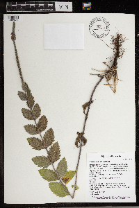 Verbena stricta Ventenat 966159[1356922]T. J. S. Whitfeld 26622020-07-17 United States, Minnesota, Washington, Lost Valley Prairie Scientific and Natural Area, 2 miles east north east of intersection of State Highway 95 and 110th Street, at dead-end of Nyberg Avenue South., 44.801097 -92.819314, 269m |
MIN:Plants | 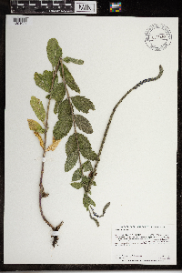 Verbena stricta Ventenat 968456[1391027]Dahlberg, Nathan B. NBD2292020-07-14 United States, Minnesota, Lac Qui Parle, Lac qui Parle 36-1 NPB. 710m North of 220th St; 1.5miles Southwest of Laq Qui Parle., 44.99 -95.88 |
MIN:Plants | Verbena stricta Ventenat []Timothy J. S. Whitfeld 33032022-07-06 United States, Minnesota, Swift, Appleton 18 Native Prairie Bank, 3.6 miles west of Appleton, 45.197618 -96.0968877, 294m |
MIN:Plants | 342076[]Sommer, T. s.n.1910-07-15 Czech Republic, Bohemia, Ortsplatz in Dereisen |
MIN:Plants | 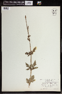 961428[1334889] Austria |
MIN:Plants | 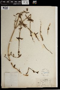 181018[1302640]Cook, Alice Carter 5691897-05-00 Spain, Gran Canaria |
MIN:Plants | Verbena x deamii Moldenke 180878[]Sheldon, Edmund S12181891-07-00 United States, Minnesota, Brown, New Ulm;;N;;, 44.315266 -94.452293 |
MIN:Plants | Verbena x perriana Moldenke 180877[]Upham, Warren s.n. United States, Minnesota, [no further data];;;;, 46 -94 |
MIN:Plants | Verbena x perriana Moldenke 181142[]Herrick, C. s.n.1877-07-17 United States, Minnesota, Hennepin, Minneapolis;;029N;24W;25, 44.979965 -93.263836 |
MIN:Plants | 897121[]Smith, Welby 275121998-08-11 United States, Minnesota, Koochiching, Pine Island State Forest. Koochiching County...Big Fork River, on the south side of Bigfork (correction: town is Grand Falls]...T 155N R 25W SE1/4 of SE1/4 of Sec 35. 155N 25W 35, 48.1972222 -93.8030556 |
MIN:Plants | 490493[]Juhnke, C. 103 CMJ FRO1998-09-04 United States, Minnesota, Goodhue, Frontenac State Park. Goodhue County ... between group camp and campgrounds ... T112N R13W SW NE NE 3;Frontenac State Park;112N;13W;03, 44.534992 -92.358902 |
MIN:Plants | 896392[]Gerdes, Lynden 41832000-08-02 United States, Minnesota, Lake, North Shore / Tettegouche State Park. T56N R08W S24NWNW Lake County ...Tettegouche State Park, vicinity of Silver Bay, MN. Cedar Creek, approximately 0.9 miles south of Lax Lake.. 056N 08W 24, 47.33958 -91.198054 |
MIN:Plants | 914979[]Smith, Welby 252251994-08-23 United States, Minnesota, Sibley, Vale Wildlife Management Area. Sibley County...Vale State Wildlife Management Area; about 3 miles northwest of Henderson. In wet springy meadow along High Island Creek...T 113N R 26W SE1/4 of NW 1/4 of Sec 27. 113N 26W 27, 44.5680556 -93.9413889 |
MIN:Plants | 510478[]Bright, R. 73-3701973-00-00 United States, Minnesota, Isanti, Isanti Co.;;;;, 45.561479 -93.295167 |
MIN:Plants | 510823[]Bright, R. 73-3711973-00-00 United States, Wisconsin, west-central [region] |
MIN:Plants | 477496[]Smith, Welby 175111990-07-29 United States, Minnesota, Steele, Rice Lake State Park. Steele County ... On the north side of Rice Lake, in Rice Lake State Park. About 7 miles east of Owatonna ... T 107N R 19W NW1/4 of SW1/4 of Sec 12. 107N 19W 12, 44.085556 -93.0655518 |
MIN:Plants | 431631[]Gerdes, Lynden; et al. 37701999-08-08 United States, Minnesota, Cook, Lower Stump River. SWNE of section;Superior National Forest;T064N R03E S22, 48.014674 -90.00009 |
MIN:Plants | 904587[]Smith, Welby 257461995-07-18 United States, Minnesota, Rock, Blue Mounds State Park. Rock County...Blue Mounds State Park, about 4 miles north-northeast of Luverne...Mound Creek...T103N R45W NW1/4 of NW1/4 of sec 24. 103N 45W 24, 43.7163889 -96.1897222 |
MIN:Plants | 180850[]Leonard, W. 141876-07-00 United States, Minnesota, Hennepin, City;;N;;, 44.979965 -93.263836 |
MIN:Plants | 180934[]Skinner, S. 2641902-07-01 United States, Minnesota, Jackson, Graham Lake, Heron Lake Region;;N;;, 43.794404 -95.322499 |
MIN:Plants | 180935[]Taylor, B. T7761891-07-00 United States, Minnesota, Pope, Glenwood;;N;;, 45.648982 -95.401248 |
MIN:Plants | 180936[]Ballard, C. B7261891-07-00 United States, Minnesota, Carver, Benton, Carver Co.;;115N;25W;, 44.776073 -93.781074 |
MIN:Plants | 180937[]G. & L. 81-11885-08-05 United States, Minnesota, Chippewa, Chippewa River;;;;, 44.934473 -95.733328 |
MIN:Plants | 180938[]Manning, Sara s.n.1883-07-28 United States, Minnesota, Wabasha, Lake City;;111N;12W;, 44.449412 -92.266844 |
MIN:Plants | 180939[]Moyer, Lycurgus s.n.1895-08-11 United States, Minnesota, Pope, Lake Minnewaska;;N;;, 45.617836 -95.450645 |
MIN:Plants | 180940[]Taylor, B. T5151891-06-00 United States, Minnesota, Blue earth, Mud Lake;;N;;, 44.167945 -93.817238 |
MIN:Plants | 180942[]Sheldon, Edmund S481891-06-00 United States, Minnesota, Le Sueur, Elysian;;109N;24W;, 44.198577 -93.673838 |
MIN:Plants | 180943[]Taylor, B. T6481891-07-00 United States, Minnesota, Faribault, Minnesota Lake;;N;;, 43.837621 -93.860827 |
MIN:Plants | 180944[]MacMillan, C.; et al. 301900-08-00 United States, Minnesota, Polk, Crookston;;150N;46W;30, 47.77414 -96.60812 |
MIN:Plants | 180945[]Ballard, C. 25021900-08-00 United States, Minnesota, Otter Tail, Fergus Falls;;N;;, 46.283015 -96.077558 |
MIN:Plants | 180946[]Burglehaus, F. s.n.1892-07-00 United States, Minnesota, Hennepin, near Minneapolis;;N;;, 44.963488 -93.258331 |
MIN:Plants | 180947[]Frost, W. s.n.1892-07-00 United States, Minnesota, Kandiyohi, Willmar;;N;;, 45.121908 -95.043342 |
MIN:Plants | 180948[]Sheldon, Edmund S28801892-07-00 United States, Minnesota, Kanabec, Mora, Kanabec Co.;;039N;24W;, 45.876903 -93.293835 |
MIN:Plants | 180949[]Sheldon, Edmund S7661891-07-00 United States, Minnesota, Brown, Sleepy Eye;;N;;, 44.297183 -94.72415 |
MIN:Plants | 180950[]Ballard, C. 26471900-08-00 United States, Minnesota, Kittson, St. Vincent;;163N;51W;, 48.9667 -97.2167 |
MIN:Plants | 180951[]Herrick, C. 103-21877-07-09 United States, Minnesota, Hennepin, Minneapolis;;N;;, 44.979965 -93.263836 |
MIN:Plants | 180952[]Ballard, C. 30991909-08-13 United States, Minnesota, Clay, Muskoda [historic RR station near Hawley], Red River Valley;;139N;45W;17, 46.854778 -96.396816 |
MIN:Plants | 180953[]Ballard, C. s.n.1901-08-09 United States, Minnesota, Clay, Moorhead, Red River Valley;;N;;, 46.873852 -96.767581 |
MIN:Plants | 180954[]Ainslie, G. 30591902-07-14 United States, Minnesota, Olmsted, Rochester;;106N;14W;, 43.97834 -92.49834 |
MIN:Plants | 180955[]Holzinger, John s.n1886-07-00 United States, Minnesota, Winona, Winona Co.;;N;;, 43.98685 -91.779129 |
MIN:Plants | 180956[]Aiton, G. s.n.1889-07-00 United States, Minnesota, Hennepin, [no further data];;;;, 45 -93.47 |
MIN:Plants | 180958[]Oestlund, O. s.n.1886-07-00 United States, Minnesota, Hennepin, Minneapolis;;N;;, 44.979965 -93.263836 |
MIN:Plants | 180959[]Kassube, J. s.n.1877-00-00 United States, Minnesota, Hennepin, Minneapolis;;N;;, 44.979965 -93.263836 |
MIN:Plants | 180960[]Sheldon, Edmund S29701892-07-00 United States, Minnesota, Mille Lacs, Milaca;;N;;, 45.755799 -93.654408 |
MIN:Plants | 180961[]Ballard, C. B2931891-06-00 United States, Minnesota, Scott, Jordan, Scott Co.;;114N;23W;, 44.66532 -93.627759 |
MIN:Plants | 180962[]Ballard, C. B5291891-07-00 United States, Minnesota, Scott, Cleary's Lake;;114N;21W;, 44.691509 -93.392626 |
MIN:Plants | 180963[]Sheldon, Edmund S30851892-07-00 United States, Minnesota, Mille Lacs, Milaca;;N;;, 45.755799 -93.654408 |
MIN:Plants | 180964[]Sheldon, Edmund s.n.1895-06-00 United States, Minnesota, Hennepin, Ft. Snelling;Fort Snelling Military Reservation;N;;, 44.890943 -93.184951 |
MIN:Plants | 180972[]Campbell, Jennie C661896-07-00 United States, Minnesota, Stearns, Rockville;;123N;29W;, 45.471909 -94.340827 |
MIN:Plants | 180973[]Campbell, Jennie C281896-07-00 United States, Minnesota, Stearns, St. Cloud;;N;;, 45.557693 -94.1603 |
MIN:Plants | 180974[]Wheeler, William 4031899-07-24 United States, Minnesota, Houston, Jefferson;Dorer Memorial Hardwood State Forest;101N;04W;35, 43.50806 -91.28287 |
MIN:Plants | 180975[]Campbell, Jennie s.n.1897-07-00 United States, Minnesota, Otter Tail, Girard;;133N;39W;, 46.326001 -95.592385 |
MIN:Plants | 180976[]Sandberg, John s.n.1886-08-00 United States, Minnesota, Goodhue, [no further data];;;;, 44.40976099 -92.72282341 |
MIN:Plants | 180978[]Ballard, C. B10951892-07-00 United States, Minnesota, Nicollet, Swan Lake, Nicollet Co.;;N;;, 44.30887 -94.262002 |
MIN:Plants | 180979[]Sandberg, John s.n.1890-07-00 United States, Minnesota, Hennepin, [no further data];;;;, 45 -93.47 |
MIN:Plants | 180980[]Sandberg, John s.n.1889-08-00 United States, Minnesota, Hennepin, [no further data];;;;, 45 -93.47 |
MIN:Plants | 264140[]Holzinger, John s.n.1901-07-00 United States, Minnesota, Winona, Winona Co.;;N;;, 43.98685 -91.779129 |
MIN:Plants | 265489[]Goldsmith, G. G611912-00-00 United States, Minnesota, Rice, Northfield;;N;;, 44.458298 -93.161604 |
MIN:Plants | 265620[]Stevenson, J. 1201912-07-05 United States, Minnesota, Beltrami, Bemidji;;N;;, 47.536341 -94.82277 |
MIN:Plants | 267042[]Stevenson, J. 2711912-08-02 United States, Minnesota, Beltrami, Bemidji;;N;;, 47.536341 -94.82277 |
MIN:Plants | 267051[]Stevenson, J. 2711912-08-02 United States, Minnesota, Beltrami, Bemidji;;N;;, 47.536341 -94.82277 |
MIN:Plants | 270002[]Wheeler, William 431893-07-00 United States, Minnesota, Houston, Winnebago Valley;Dorer Memorial Hardwood State Forest;N;;, 43.537379 -91.40119 |
MIN:Plants | 276151[]Grant, Martin 30731929-08-13 United States, Minnesota, Becker, Itasca Park. Becker Co.; De Soto Lake, NE-NE3 T142 R36.;Itasca State Park;142N;36W;3, 47.145259 -95.222784 |
MIN:Plants | 277418[]Rosendahl, C. 56111928-07-05 United States, Minnesota, Becker, De Soto Lake, Itasca Park;Itasca State Park;143N;36W;, 47.145259 -95.222784 |
MIN:Plants | 277619[]Hotchkiss, N.; et al. 2931930-07-18 United States, Minnesota, Watonwan, Watonwan Co. Kansas Lake;;105N;32W;, 43.9167 -94.7 |
MIN:Plants | 278286[]Roberts, Thomas s.n.1877-07-00 United States, Minnesota, Hennepin, Minneapolis;;N;;, 44.979965 -93.263836 |
MIN:Plants | 282694[]Swanson, Gustav s.n.1932-08-14 United States, Minnesota, Lake of the Woods, Northwest Angle;Northwest Angle;N;;, 49.345235 -94.970765 |
MIN:Plants | 284609[]Rosendahl, C. 6631902-07-01 United States, Minnesota, Houston, Spring Grove;;101N;07W;, 43.543165 -91.672028 |
MIN:Plants | 291847[]Fryklund, P. s.n.1925-07-12 United States, Minnesota, Roseau, [no further data];;;;, 48.791028 -95.795207 |
MIN:Plants | 306906[]Cottrell, R. s.n.1935-08-10 United States, Minnesota, Anoka, Fridley;;030N;24W;, 45.086076 -93.263282 |
MIN:Plants | 306928[]Cottrell, R. s.n.1935-08-10 United States, Minnesota, Anoka, Fridley region;;030N;24W;, 45.086076 -93.263282 |
MIN:Plants | 335535[]Lakela, Olga 18431936-09-06 United States, Minnesota, Saint Louis, U.S. Gov. Prop, near the N Breakwater, Duluth; Sec. 20;;N;;20, 46.7833 -92.1 |
MIN:Plants | 346733[]Lakela, Olga 21081937-08-01 United States, Minnesota, Saint Louis, At the jnc of Snively Boulevard and Jean Du Luth Road, Duluth;;N;;, 46.7833 -92.1 |
MIN:Plants | 347256[]Grant, Martin 68071936-08-19 United States, Minnesota, Becker, Itasca Park. Becker Co. De Soto Lake;Itasca State Park;142N;36W;3, 47.145259 -95.222784 |
MIN:Plants | 348140[]Jukkola, E. 1201937-07-17 United States, Minnesota, Anoka, Moore Lake;;030N;24W;, 45.077013 -93.252399 |
MIN:Plants | 348974[]Nielsen, E. 751930-07-23 United States, Minnesota, Beltrami, Near outlet of Cass Lake into Mississippi River;Chippewa National Forest / Leech Lake Indian Reservation;N;;, 47.452852 -94.485786 |
MIN:Plants | 350711[]Hedman, H. 741938-07-00 United States, Minnesota, Hennepin, N shore Brown's Bay, L. Minnetonka;;N;;, 44.954978 -93.545517 |
MIN:Plants | 360237[]Lakela, Olga 41701940-08-31 United States, Minnesota, Saint Louis, Shore of Sand Lake, Virginia Lodge, hwy 61;;N;;, 48.483546 -92.838098 |
MIN:Plants | 360306[]Lakela, Olga 39821940-08-11 United States, Minnesota, Saint Louis, Near Interstate Bridge, 16th Ave. W, Rice Point, Duluth;;N;;, 46.7833 -92.1 |
MIN:Plants | 361807[]Lakela, Olga 38001940-07-29 United States, Minnesota, Saint Louis, St. Louis River terrace at Fond du Lac;;048N;15W;, 46.659664 -92.273248 |
MIN:Plants | 365001[]Buell, Murray 20191940-08-19 United States, Minnesota, Becker, De Soto Lake, Itasca Park;Itasca State Park;142N;36W;, 47.145259 -95.222784 |
MIN:Plants | 367265[]Moore, John; Moore, Marjorie 103681938-08-29 United States, Minnesota, Lake of the Woods, Rapid River, Clementson;;N;;, 48.6833 -94.4333 |
MIN:Plants | 369739[]Lakela, Olga 46781941-08-07 United States, Minnesota, Saint Louis, Above Skyline Parkway, 38th Ave. W, Duluth;;N;;, 46.7833 -92.1 |
MIN:Plants | 369765[]Lakela, Olga 48501941-08-23 United States, Minnesota, Lake, Gooseberry River above the lower falls;Gooseberry Falls State Park / North Shore;054N;09W;22, 47.146872 -91.463229 |
MIN:Plants | 372539[]Moore, John; et al. 147671941-07-07 United States, Minnesota, Otter Tail, E shore of West Lost Lake, 7.2 mi N of Underwood. Otter Tail Co.;;;;, 46.389479 -95.870885 |
MIN:Plants | 372981[]Moore, John; et al. 146121941-07-05 United States, Minnesota, Wright, 1 mi NW of Annandale. Wright Co.;;;;, 45.272981 -94.138975 |
MIN:Plants | 375101[]Lakela, Olga 51961942-08-30 United States, Minnesota, Pine, Pine Co. Near Askov, hwy 23;;043N;19W;, 46.186614 -92.78242 |
MIN:Plants | 375172[]Lakela, Olga 51551942-08-18 United States, Minnesota, Saint Louis, At Sparta;;N;;, 47.467427 -92.477406 |
MIN:Plants | 381776[]Moore, John 156851942-09-10 United States, Minnesota, Washington, Washington Co.; small lake south side of road, 1/2 mi west of Maple Island Station;;031N;20W;17, 45.174254 -92.865655 |
MIN:Plants | 385887[]Lakela, Olga 58141944-08-21 United States, Minnesota, Lake, near Gooseberry River on the interior road from Beaver Bay to Stewart River.;;N;;, 47.2577 -91.300444 |
MIN:Plants | 396778[]Stevens, O. s.n.1947-07-18 United States, Minnesota, Clay, [no further data];Buffalo River State Park;139N;46W;10, 46.863699 -96.472855 |
MIN:Plants | 405009[]Benson, Robert 1401941-08-20 United States, Minnesota, Kandiyohi, Kandiyohi Co.; State Game Refuge - New London; T121 R33. [prob. Dietrich Lange Wildlife Management Area];Dietrich Lange Wildlife Management Area;121N;33W;, 45.301076 -94.944177 |
MIN:Plants | 405036[]Benson, Robert 61941-07-29 United States, Minnesota, Anoka, Carlos Avery Refuge; T33N R22W Sec. 34;Carlos Avery Wildlife Management Area;033N;22W;34, 45.304461 -93.070943 |
MIN:Plants | 407449[]Lakela, Olga 96161949-09-01 United States, Minnesota, Saint Louis, Shore of small island in Lake Kabetogama;Voyageurs National Park;N;;, 48.470908 -93.008801 |
MIN:Plants | 407558[]Lakela, Olga 91271949-07-20 United States, Minnesota, Saint Louis, Prairie Lake;;050N;20W;, 46.79124 -92.904888 |
MIN:Plants | 412324[]Moore, John; Moore, Marjorie 116411939-08-10 United States, Minnesota, Kittson, Along the North Branch of Two River; Sec. 6 Cannon Twp.;;162N;46W;6, 48.88299 -96.655949 |
MIN:Plants | 412993[]Moore, John; Moore, Marjorie 120281939-08-22 United States, Minnesota, Lake of the Woods, Shore at the mouth of the Rapid River, Clementson;;N;;, 48.6833 -94.4333 |
MIN:Plants | 413590[]Moore, John; Moore, Marjorie 109771939-07-19 United States, Minnesota, Lake of the Woods, Near Pine Creek, Angle Inlet;Northwest Angle;N;;, 49.353711 -95.002845 |
MIN:Plants | 416777[]Lakela, Olga 94371949-08-27 United States, Minnesota, Saint Louis, Shore of Lake Kabetogama, near Park Point Resort;Voyageurs National Park;N;;, 48.470908 -93.008801 |
MIN:Plants | 419579[]Lakela, Olga 109471950-07-00 United States, Minnesota, Saint Louis, On Swan River Road, near Duluth Airport, Duluth;;N;;, 46.7833 -92.1 |
Google Map
Google Maps is a web mapping service provided by Google that features a map that users can pan (by dragging the mouse) and zoom (by using the mouse wheel). Collection points are displayed as colored markers that when clicked on, displays the full information for that collection. When multiple species are queried (separated by semi-colons), different colored markers denote each individual species.