University of Minnesota
http://www.umn.edu/
612-625-5000
http://www.umn.edu/
612-625-5000
Minnesota Biodiversity Atlas
Bell Museum
Dataset: MIN-Plants
Taxa: Cornus
Search Criteria: excluding cultivated/captive occurrences
Bell Museum plants | |
 MIN:Plants | 508783[]Kaul, R. 74041996-06-25 United States, Minnesota, Rice, Rice County ... Hunt's Lake, east side;;110N;22W;, 44.326687 -93.464039 |
MIN:Plants | Cornus alternifolia L. f. 398768[]Kaul, R.; et al. 69521991-05-26 United States, Minnesota, Steele, Steele County ... along Maple Creek at Mineral Springs.;;107N;20W;, 44.066112 -93.226071 |
MIN:Plants | Cornus racemosa Lamarck 455515[]Smith, Welby 279451999-06-29 United States, Minnesota, Pine, Pine County ... Banning State Park, about 3 miles SW of Askov ... T 43N R 20W NE1/4 of SW1/4 of Sec 35;Banning State Park;043N;20W;35, 46.1630556 -92.8383333 |
MIN:Plants | 488288[]Smith, Welby 287622000-07-18 United States, Minnesota, Ramsey, Ramsey County ... Battle Creek County Park, in St. Paul ... T 28N R 22W SE1/4 of SE1/4 of Sec 3;Battle Creek County Park;028N;22W;03, 44.9361111 -93.0280556 |
MIN:Plants | Cornus rugosa Lamarck 508890[]Smith, Welby 288312000-07-26 United States, Minnesota, Aitkin, Savanna Portage State Park. Aitkin County ... Savanna Portage State Park; about one mile west of Shumway Lake ... T 50N R 22W SW1/4 of SE1/4 of Sec 7.. 050N 22W 7, 46.8286111 -93.1744444 |
MIN:Plants | 485025[]Lee, Michael MDL22611998-07-20 United States, Minnesota, Wright, Wright County ... Stanley Eddy County Park 3-1/2 miles south-southwest of South Haven ...T120N R28W NW1/4 of NW1/4 Sec 5;Stanley Eddy County Park;120N;28W;5, 45.232465 -94.226148 |
MIN:Plants | Cornus rugosa Lamarck 918201[]Smith, Welby 223721993-06-08 United States, Minnesota, Dakota, Dakota County...On the south side of Highway 54, about 3 miles east of Hastings, in the Mississippi River valley... T 115N R 16W NW1/4 of SW1/4 of Sec 31. 115N 16W 31, 44.7216667 -92.7919444 |
MIN:Plants | Cornus alternifolia L. f. 472006[]Juhnke, C. 270 CMJ FRO1999-05-21 United States, Minnesota, Goodhue, Frontenac State Park Goodhue County ... along Hill Ave, south of Ratttlesnake Bluff .. T112N R13W NW NE SE 5;Frontenac State Park;112N;13W;05, 44.535196 -92.399973 |
MIN:Plants | Cornus racemosa Lamarck 520824[]Smith, Welby 288772000-08-02 United States, Minnesota, Goodhue, Frontenac State Park. Goodhue County ... Frontenac State Park, about 2 miles N-NE of Frontenac (town) ... On NE-facing bluff overlooking he Mississippi River ... T 112N R 13W NW1/4 of SE1/4 of Sec 2. 112N 13W 2, 44.5341667 -92.335 |
MIN:Plants | 473320[]Lee, Michael MDL17781997-07-26 United States, Minnesota, Stearns, On the south side of the city of Waite Park. SE1/4 of NW1/4 of NW1/4 Sec.;Quarry Park Nature Preserve & Scientific Natural Area;124N;28W;29, 45.522725 -94.229615 |
MIN:Plants | 462050[]Smith, Welby 271791998-06-01 United States, Minnesota, Mille Lacs, Kunkel Wildlife Management Area. Mille Lacs County ... Kunkel State Wildlife Management Area, about 4.5 miles west of Princeton ... T 36N R 27W SW1/4 of NE1/4 of Sec 26. 036N 27W 26, 45.5841667 -93.6638889 |
MIN:Plants | 461796[]Husveth, J. 96-1811996-07-01 United States, Minnesota, Hennepin, Hennepin Co, T118N R23W SW1/4 of the NE1/4 of S27;Wolsfeld Woods SNA;118N;23W;27, 44.999919 -93.573712 |
MIN:Plants | Cornus alternifolia L. f. 477449[]Smith, Welby 174141990-07-23 United States, Minnesota, Steele, Steele County ... Kaplan Woods City Park, on the south side of Owatonna ... T 107N R 20W NE1/4 of NW1/4 of Sec 21;;107N;20W;21, 44.0644444 -93.235 |
MIN:Plants | Cornus racemosa Lamarck 511011[]Smith, Welby 287012000-07-11 United States, Minnesota, Aitkin, Rice Lake National Wildlife Refuge. Aitkin County ... Rice Lake National Wildlife Refuge; about 5 miles S-SW of McGregor ... T 47N R 24W SE1/4 of SW1/4 of Sec 23. 047N 24W 23, 46.5388889 -93.3422222 |
MIN:Plants | 489022[]Smith, Welby 259431995-09-06 United States, Minnesota, Mower, Lake Louise State Park. Mower County ... Lake Louise State Park, about 1.5 miles north-northwest of LeRoy ... along the Upper Iowa River ... T 101N R 14W SE1/4 of SW1/4 of sec 21. 101N 14W 21, 43.527551 -92.521092 |
MIN:Plants | 461800[]Schik, K. 96-1001996-06-25 United States, Minnesota, Wilkin, Red River. SW1/4 of SE1/4 of section;;133N;47W;33, 46.290504 -96.59596 |
MIN:Plants | 510236[]US Nat. Arboretum staff 491974-00-00 Canada, New Brunswick, Albert Cnty |
MIN:Plants | Cornus alternifolia L. f. 435779[]Smith, Welby 151821989-05-30 United States, Minnesota, Kanabec, Mille Lacs Wildlife Management Area. Kanabek [sic] Co.; Mille Lacs State Wildlife Management Area, about 9 miles northwest of Mora; SW1/4 SW1/4 sec. 16 T 40N R 25W. 040N 25W 16, 45.9511111 -93.4711111 |
MIN:Plants | Cornus alternifolia L. f. 912487[]Smith, Welby 228401993-07-14 United States, Minnesota, Sibley, Vale Wildlife Management Area. Sibley County...Vale State Wildlife Management Area, ca 2.5 miles N-NW of Henderson; in the valley of High Island Creek, ca 2.5 miles SW of its confluence with the Minn R...T 113N R 26W NE1/4 of SW1/4 of Sec 27. 113N 26W 27, 44.5625 -93.9427778 |
MIN:Plants | Cornus racemosa Lamarck 511736[]Smith, Welby 290622000-08-31 United States, Minnesota, Anoka, Carlos Avery Wildlife Management Area. Anoka County ... Carlos Avery State Wildlife Management Area. On the west side of Linwood lake, about 4.5 miles west of Wyoming (town). T 33N R 22W SE1/4 of NW1/4 of Sec 16. 033N 22W 16, 45.3491667 -93.0969444 |
MIN:Plants | 508769[]Kaul, R.; et al. 69801991-06-24 United States, Minnesota, Cook, Cook County ... Near the mouth of the Onion River gorge, Lutsen, where it opens to Lake Superior.;North Shore / Superior National Forest;059N;04W;, 47.599359 -90.844189 |
MIN:Plants | 907569[]Lee, Michael MDL42052006-06-01 United States, Minnesota, Wadena, Wadena County...On the west side of the Crow Wing River four miles south-southwest of Oylen one mile south of Knob Hill campground...T135N R33W W1/2 of SW1/4 of SW1/4 Sec. 11...UTM: 5152879N 360336E. 135N 33W 11, 46.520782 -94.811002 |
MIN:Plants | 510336[]US Nat. Arboretum staff 661975-00-00 United States, Minnesota, Crow Wing, Crow Wing Co.;;;;, 46.482372 -94.070879 |
MIN:Plants | Cornus rugosa Lamarck 428926[]Smith, Welby 279631999-07-01 United States, Minnesota, Washington, Afton State Park. Washington County ... Afton State Park; about 7 miles NE of Hastings ... bluff overlooking St. Croix River ... T 27N R 20W NE1/4 of NW1/4 of Sec 11. 027N 20W 11, 44.8466667 -92.7705556 |
MIN:Plants | Cornus rugosa Lamarck 477253[]Lee, Michael MDL15991996-09-19 United States, Minnesota, Kandiyohi, Sibley State Park. Kandiyohi County ... Along the south side of Timber Lake 8 miles northwest of New London ... T122N R35W SE1/4 SW1/4 SE1/4 Sec. 35. 122N 35W 35, 45.33294 -95.03988 |
MIN:Plants | 912789[]Smith, Welby 241791994-05-30 United States, Minnesota, Itasca, Itasca County...At Bowstring Lodge; on the north side of Bowstring Lake...T 147N R 25W SW1/4 of SW1/4 of Sec 6;Chippewa National Forest;147N;25W;06, 47.5716667 -93.9030556 |
MIN:Plants | Cornus racemosa Lamarck 510327[]Arboretum, Cary 73-281973-00-00 United States, District of Columbia, USNA [Nat. Arboretum] |
MIN:Plants | Cornus alternifolia L. f. 906123[]Clancy, J.; et al. 72008-09-27 United States, Minnesota, Hennepin, Minnehaha Falls Park. Hennepin County, Minnehaha Falls Park, approximately 0.25 miles south east of the falls ...Minnehaha Creek, 100 feet south of Den Pen Area Bridge. 1/4 SE of 1/4 NE of Section 18, Township 28N, Range 23W.. 028N 23W 18, 44.9147222 -93.2097222 |
MIN:Plants | Cornus amomum Miller 456174[]Smith, Welby 281651999-08-20 United States, Minnesota, Freeborn, Myre Big Island State Park. Freeborn County ... Helmer Myrre State Park, about 4 miles southeast of Alber Lea ... Albert Lea Lake ... T102N R20W SW1/4 of NW1/4 of Sec 19. 102N 20W 19, 43.6258333 -93.2861111 |
MIN:Plants | Cornus rugosa Lamarck 480855[]Smith, Welby 244881994-06-27 United States, Minnesota, Stearns, Stearns County ... Birch Lake State Forest, about 4 miles south of Grey Eagle ... T127N R33W NE1/4 of NE1/4 of Sec 36;Birch Lakes State Forest;127N;33W;36, 45.7730556 -94.7705556 |
MIN:Plants | Cornus racemosa Lamarck 898316[]Smith, Welby 280281999-07-19 United States, Minnesota, Nicollet, Fort Ridgely State Park. Nicollet County...Fort Ridgely State Park, about 10 miles north of Sleepy Eye...along a small tributary of the Minnesota River...T 111N R 32W NE1/4 of NE1/4 of Sec 6. 111N 32W 6, 44.4538889 -94.735 |
MIN:Plants | 482405[]Wheeler, Gerald 169591997-08-07 United States, Minnesota, Swift, Swift Co.; Ca. 9 mi. N of Murdock on Rte. 33, E of road; NW1/4 NE1/4 Sec. 30 T122N R37W (Kerkhoven 30);Camp Kerk Wildlife Management Area;122N;37W;30, 45.347311 -95.368095 |
MIN:Plants | 540021[]Tester, John s.n.1957-05-22 United States, Minnesota, Mahnomen, 3-4 miles w. and 1 mile s. of Waubun. ;Waubun Prairie Wildlife Management Area / White Earth Indian Reservation;143N;42W;33, 47.158904 -96.00743 |
MIN:Plants | 905209[]Smith, Welby 294822004-08-19 United States, Minnesota, Aitkin, Aitkin County...At the north end of Beauty Bay of Cedar Lake...T47N R27W SW1/4 of NE1/4 of Sec 31;;047N;27W;31, 46.5141667 -93.7980556 |
MIN:Plants | 509371[]DeMink, L. 22422001-10-05 United States, Minnesota, Sherburne, Sherburne National Wildlife Refuge ... NW 1/4 13-34-27;Sherburne National Wildlife Refuge;034N;27W;13, 45.436474 -93.642941 |
MIN:Plants | Cornus alternifolia L. f. 509066[]Smith, Welby 287352000-07-12 United States, Minnesota, Mille Lacs, Mille Lacs Kathio State Park. Mille Lacs County ... Mille Lacs Kathio State Park, about 8 miles northwest of Onamia ... T 42N R 27W SW1/4 of SE1/4 of Sec 5. 042N 27W 5, 46.1286111 -93.7725 |
MIN:Plants | 508074[]Gerdes, Lynden 25501998-06-01 United States, Minnesota, Cook, Superior National Forest. T65N R04W S26SWSENE. Cook County ... Superior National Forest, gravel pit area just north of the Gunflint Trail (Cty. 12) / FR 1347 junction.. 065N 04W 26 |
MIN:Plants | 915995[]Smith, Welby 251971994-08-19 United States, Minnesota, Pine, Banning State Park. Pine County ... Banning State Park, about 3 miles north-northwest of Sandstone ... Kettle River ... T43N R20W NW1/4 of SW1/4 of Sec 35. 043N 20W 35, 46.1625 -92.8402778 |
MIN:Plants | 510330[]Arboretum, Cary 73-271973-00-00 United States, New York, Dutchess, Dutchess County |
MIN:Plants | 508089[]Smith, Welby 284842000-05-31 United States, Minnesota, Houston, Houston County ... About 3 miles south of Houston (town) ... T 103N R 6W NW1/4 of NE1/4 of Sec 16.;Dorer Memorial Hardwood State Forest;103N;06W;16, 43.7316667 -91.5583333 |
MIN:Plants | 479986[]Wheeler, Gerald 189361998-06-06 United States, Minnesota, Redwood, Redwood Co.; Ca. 4.5 mi. NE of Belview, 0.4 mi. E of jct. of Rte(s). 19 and 58; NE1/4 NE1/4 NW1/4 Sec. 27 T114N R37W (Swedes Forest 27). 114N 37W 27, 44.650505 -95.289332 |
MIN:Plants | 509342[]Kaul, R.; et al. 69751991-06-24 United States, Minnesota, Cook, Cook County ... Near the mouth of the Onion River gorge, where it opens to Lake Superior.;North Shore / Superior National Forest;059N;04W;, 47.599359 -90.844189 |
MIN:Plants | Cornus racemosa Lamarck 453473[]Nation, R. 94-2771994-07-18 United States, Minnesota, Mower, Lake Louise State Park. Mower Co.; Tract 1B. T101N R14W W1/2 SE1/4 of Sec. 21;Lake Louise State Park;101N;14W;21, 43.536578 -92.519043 |
MIN:Plants | 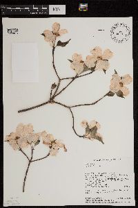 428041[1299475]Raven, Peter; Raven, Tamra Engelhorn 277841989-04-30 United States, Missouri, Jefferson, Jefferson County. 6.5 mi (10.5 km) W of DeSoto. T 39N. R 3E. Sec 11 ... along Mammoth Creek, ca. 0.3 mi (500 m) NE of its confluence with Big River. Crossing MC at road.. 039N 03E 11, 38.125 -90.675, 170m |
MIN:Plants | Cornus racemosa Lamarck 918208[]Smith, Welby 224471993-06-18 United States, Minnesota, Grant, Grant County ... South side of Ask Lake, about 1.5 miles east-southeast of Ashby ... T130N R41W NW1/4 of SW1/4 of Sec 12;;130N;41W;12, 46.0847222 -95.7886111 |
MIN:Plants | Cornus rugosa Lamarck 478280[]Smith, Welby 286972000-07-11 United States, Minnesota, Aitkin, Rice Lake National Wildlife Refuge. Aitkin County ... Rice Lake National Wildlife Refuge; about 5 miles S-SW of McGregor ... T 47N R 24W SE1/4 of SW1/4 of Sec 23. 047N 24W 23, 46.538887 -93.3422241 |
MIN:Plants | Cornus alternifolia L. f. 919981[]Smith, Welby 221871993-05-20 United States, Minnesota, Otter Tail, Inman Wildlife Management Area. Otter Tail County...Inman State Wildlife Management Area, about 7 miles south of Deer Creek (town)...T133N R37W SE1/4 of SE1/4 of Sec 33. 133N 37W 33, 46.2847222 -95.3463889 |
MIN:Plants | 427223[]Smith, Welby 231201993-07-28 United States, Minnesota, Grant, National Waterfowl Production Area. At the northwest end of Lee Lake, about six miles east of Elbow Lake (town).;Redhead Slough Wildlife Management Area;129N;41W;8, 45.9938889 -95.8583298 |
MIN:Plants | 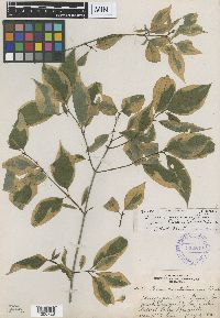 Cornus racemosa f. nielsenii John W. Moore 352542[1000728]Nielsen, E. 21161933-07-05 United States, Minnesota, Becker, Northwest of Long Lake. Detroil Lakes.;;139N;42W;, 46.847753 -95.985356 |
MIN:Plants | Cornus racemosa Lamarck 489000[]Smith, Welby 290332000-08-23 United States, Minnesota, Le Sueur, Le Sueur County ... Sakatah Lake State Park; about 2 miles east of Waterville ... T109N R23W NW1/4 of NE1/4 of Sec 25;Sakatah Lake State Park;109N;23W;25, 44.2241669 -93.5294418 |
MIN:Plants | Cornus racemosa Lamarck 493551[]Smith, Welby 272251998-06-07 United States, Minnesota, Redwood, Cedar Rock Wildlife Management Area. Redwood County ... Cedar Rock State Wildlife Management Area, in the Minnesota River Valley, about 5 miles north-northwest of Redwood Falls ... T 113 R 36W NE1/4 of NW1/4 of Sec 11. 113N 36W 11, 44.6136093 -95.1541672 |
MIN:Plants | Cornus racemosa Lamarck 904206[]Smith, Welby 279791999-07-09 United States, Minnesota, Swift, Swift County...Monson Lake State Park, about 9 miles north of Kerkhoven...T 121N R 37W NE1/4 of NW1/4 of Sec 1;Monson Lake State Park;121N;37W;01, 45.3236111 -95.2688889 |
MIN:Plants | Cornus alternifolia L. f. 453994[]Anderson, Chel 99672000-05-19 United States, Minnesota, Cook, Cook Co.; Spring Beauty Hardwoods SNA; T62N R04E SW1/4 of SW1/4 of Sec. 6;North Shore / Spring Beauty Northern Hardwoods Scientific Natural Area;062N;04E;6, 47.881641 -89.986351 |
MIN:Plants | 912418[]Smith, Welby 231201993-07-28 United States, Minnesota, Grant, National Waterfowl Production Area. At the northwest end of Lee Lake, about six miles east of Elbow Lake (town).;Redhead Slough Wildlife Management Area;129N;41W;08, 45.9938889 -95.8583333 |
MIN:Plants | Cornus racemosa Lamarck 462116[]Smith, Welby 157181989-07-17 United States, Minnesota, Benton, Benlacs Wildlife Management Area. Benton County ... Benlacs State Wildlife Management Area, about 7 miles southeast of Foley ... SE1/4 SE1/4 section 12, T 36N R 28W. 036N 28W 12, 45.6208344 -93.7630539 |
MIN:Plants | 477542[]Bright, R. 73-2201973-00-00 United States, Idaho, Franklin, [no further data] |
MIN:Plants | Cornus rugosa Lamarck 911041[]Smith, Welby 244881994-06-27 United States, Minnesota, Stearns, Stearns County... In Birch Lake State Forest, about 4 miles south of Grey Eagle... T127N R33W NE1/4 of NE1/4 of Sec 36;Birch Lakes State Forest;127N;33W;36, 45.7730556 -94.7705556 |
MIN:Plants | Cornus racemosa Lamarck 474200[]Swanson, Gary 13171999-06-14 United States, Minnesota, Sherburne, Sherburne National Wildlife Refuge; SENW 22-35-27; FQURU1-01;Sherburne National Wildlife Refuge;035N;27W;22, 45.508655 -93.685329 |
MIN:Plants | Cornus racemosa Lamarck 897917[]Scott, P. 17592004-07-21 United States, Minnesota, Cook, Cook Co. ... by Magnetic Rock Tr. T65N R4W sec. 22 NWSESE.;Superior National Forest;065N;04W;22, 48.098653 -90.825702 |
MIN:Plants | Cornus alternifolia L. f. 437927[]Lee, Michael MDL29242001-06-07 United States, Minnesota, Lake, Superior National Forest. Lake County ... Superior National Forest ... Between Paccini and Nine Mile Lakes, 2 1/4 miles north-northwest of Cramer ... T59N R6W SE1/4 of SE1/4 of SW1/4 Sec. 27. 059N 06W 27, 47.565886 -91.075765 |
MIN:Plants | 480913[]Kaul, R.; et al. 57761987-05-25 United States, Minnesota, Rice, Rice County ... Hunt's Lake;;110N;22W;, 44.326687 -93.464039 |
MIN:Plants | Cornus alternifolia L. f. 493440[]Smith, Welby 288682000-08-01 United States, Minnesota, Carlton, Carlton County ... Along the Willard Munger State Trail, about 1/4 mile east of Carlton ... T 48N R 16W NW1/4 of NE1/4 of Sec 7. 048N 16W 7, 46.6622238 -92.4161148 |
MIN:Plants | 510335[]US Nat. Arboretum staff 791978-00-00 United States, Montana, Flathead, Flathead Co. |
MIN:Plants | Cornus racemosa Lamarck 912490[]Smith, Welby 229731993-07-20 United States, Minnesota, Sibley, Sibley County ... Between T.H. 5 and the adjacent railroad tracks; about one mile northeast of Arlington ... T113N R27W SE1/4 of NE1/4 of Sec 3. 113N 27W 3, 44.6272222 -94.0519444 |
MIN:Plants | 904513[]Smith, Welby 267481997-08-06 United States, Minnesota, Kanabec, Kanabec County...Fish Lake, about 4 miles south-southwest of Mora...T 39N R 24W SW1/4 of SW1/4 of Sec 34;;039N;24W;34, 45.8205556 -93.3255556 |
MIN:Plants | Cornus rugosa Lamarck 455349[]Cholewa, A. 26152002-08-08 United States, Minnesota, Clearwater, Clearwater Co. Itasca State Park. Road to Ozawindib Lake. T143N R36W Sec. 5.;Itasca State Park;143N;36W;5, 47.231426 -95.265784 |
MIN:Plants | 510325[]US Nat. Arboretum staff 531974-00-00 United States, District of Columbia, Washington |
MIN:Plants | Cornus racemosa Lamarck 510328[]US Nat. Arboretum staff 511974-00-00 United States, District of Columbia, USNA [Nat. Arboretum] |
MIN:Plants | 499751[]Whitfeld, T.J.S. 4272003-06-20 United States, Minnesota, Douglas, Douglas County ... 2 miles north of Spruce Center; 1 mile east County Hwy. 3; 1/2 mile south of the Douglas/Otter Tail county line ... T130N R36W SWNW 3. 130N 36W 3, 46.099598 -95.198038 |
MIN:Plants | 461891[]Smith, Welby 156471989-07-11 United States, Minnesota, Kanabec, Kanabek [sic] County ... on the northeast side of Highway 65, about 7.5 miles south of Mora ... NE1/4 SE1/4 section 30, T 38N R 23W. 038N 23W 30, 45.7519455 -93.2508316 |
MIN:Plants | 485018[]Lee, Michael; et al. MDL23421998-08-04 United States, Minnesota, Wright, Wright County ... In old channel of Crow River 3-1/2 miles south-southwest of St. Michael ... T120N R24W NW1/4 of SE1/4 Sec. 35. 120N 24W 35, 45.153353 -93.66832 |
MIN:Plants | 508790[]Kaul, R. 71521992-08-06 United States, Minnesota, Saint Louis, St. Louis County ... north of Hibbing, near the Hull-Rust-Mahoning iron mine.;;;;, 47.449099 -92.972133 |
MIN:Plants | 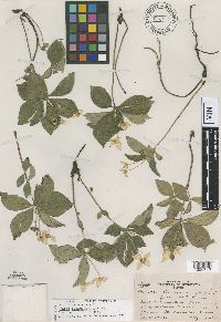 520564[1000712]Lakela, Olga 69331947-07-20 United States, Minnesota, Saint Louis, railroad tracks, 1 mi. N.E. of Palmers;North Shore;051N;12W;02, 46.932236 -91.825361 |
MIN:Plants | Cornus racemosa Lamarck 509395[]Swanson, Gary 22382001-10-05 United States, Minnesota, Sherburne, Sherburne National Wildlife Refuge ... NW 1/4 13-34-27;Sherburne National Wildlife Refuge;034N;27W;13, 45.436474 -93.642941 |
MIN:Plants | Cornus amomum Miller 427014[]Smith, Welby 271791998-06-01 United States, Minnesota, Mille Lacs, Kunkel Wildlife Management Area. Mille Lacs County ...Kunkel State Wildlife Management Area, about 4.5 miles west of Princeton ... T36N R27W SW1/4 of NE1/4 of Sec 26. 036N 27W 26, 45.5841667 -93.6638889 |
MIN:Plants | Cornus alternifolia L. f. 510520[]Smith, Welby 287582000-07-18 United States, Minnesota, Ramsey, Ramsey County ... Battle Creek County Park, in St. Paul ... T 28N R 22W SE1/4 of SE1/4 of Sec 3;Battle Creek County Park;028N;22W;03, 44.9361111 -93.0280556 |
MIN:Plants | Cornus racemosa Lamarck 898326[]Smith, Welby 278891999-06-14 United States, Minnesota, Polk, Polk County...Bee Lake State Wildlife Management Area, about 2 miles SW of Erskine...T148N R42W NE1/4 of SE1/4 of Sec 7;Bee Lake Wildlife Management Area;148N;42W;07, 47.6513889 -96.0494444 |
MIN:Plants | 488047[]Smith, Welby 288052000-07-22 United States, Minnesota, Anoka, Anoka County ... In the City of Blaine, just south of 95th street & east of I35W ... T31N R23W SW1/4 of SW1/4 of Sec 26;;031N;23W;26, 45.1399994 -93.1713867 |
MIN:Plants | Cornus alternifolia L. f. 905455[]Gerdes, Lynden 44712001-08-23 United States, Minnesota, Lake, North Shore / Wolf Ridge Environmental Center. T57N R07W S27NWSW. Lake County...Wolf Ridge Environmental Learning Center. Finland, MN. Approx. 0.25 mile N of the Baptism River...wetland (drainage) to Sawmill Creek. 057N 07W 27, 47.393404 -91.203744 |
MIN:Plants | Cornus rugosa Lamarck 510662[]US Nat. Arboretum staff 771978-00-00 United States, Minnesota, Crow Wing, Crow Wing Co.;;;;, 46.482372 -94.070879 |
MIN:Plants | 480914[]Kaul, R. 64271989-06-19 United States, Minnesota, Clearwater, Clearwater County ... along the east shore of Lake Itasca, just north of the biological Station.;Itasca State Park;143N;36W;, 47.19557 -95.233216 |
MIN:Plants | 917256[]Smith, Welby 223111993-06-03 United States, Minnesota, Sibley, Vale Wildlife Management Area. Sibley County ... Vale State Wildlife Management Area; in the valley of High Island Creek, about 2.5 miles southwest its confluence with the Minnesota River ... T113N R26W NE1/4 of SW1/4 of Sec 27. 113N 26W 27, 44.5625 -93.9427778 |
MIN:Plants | 485034[]Lawrence, Donald s.n.1953-08-22 United States, Alaska, Glacier Bay National Park. Beartrack Cove in Glacier Bay.;Glacier Bay National Park;;;, 58.797428 -136.838127 |
MIN:Plants | Cornus alternifolia L. f. 912969[]Smith, Welby 241881994-05-31 United States, Minnesota, Itasca, Itasca County... In Scenic State Park, about 9 miles south-southest of Effie...T 60N R 25W SW1/4 of SW1/4 of Sec 6;Scenic State Park;060N;25W;06, 47.7027778 -93.5733333 |
MIN:Plants | 476898[]Smith, Welby 289162000-08-08 United States, Minnesota, Lake, Lake County ... Tettegouche State Park, about one mile west of Illgen City ... T 56N R 7W NW1/4 of SE1/4 of Sec 10;North Shore / Tettegouche State Park;056N;07W;10, 47.3463898 -91.2050018 |
MIN:Plants | Cornus racemosa Lamarck 488076[]Smith, Welby 285862000-06-17 United States, Minnesota, Becker, Becker County ... About 0.5 mile west of Ogema ... T 142N R 41W NE1/4 of NE1/4 of Sec 24;White Earth Indian Reservation;142N;41W;24, 47.106945 -95.9349976 |
MIN:Plants | 477356[]Lee, Michael; et al. MDL13481996-07-03 United States, Minnesota, Houston, Upper Mississippi National Wildlife Refuge. Houston County ... Reno Bottoms. Mississippi River floodplain 2 miles southeast of Reno ... T101N R4W SE1/4 NE1/4 SW1/4 Sec. 1. 101N 04W 1, 43.579801 -91.262964 |
MIN:Plants | 601171[]Munns, C. 4541966-06-23 United States, Alaska, Wonder Lake, McKinley National Park;Denali National Park;;;, 63.45884 -150.86412 |
MIN:Plants | Cornus rugosa Lamarck 499271[]Mason, Harriet; et al. NSP98-451998-06-06 United States, Minnesota, Rice, North of west electric transformer almost up to the sight of house (lath stake). SWcorner of section;Nerstrand Woods State Park;110N;19W;16, 44.334371 -93.111203 |
MIN:Plants | Cornus alternifolia L. f. 916530[]Smith, Welby 223181993-06-03 United States, Minnesota, Sibley, Vale Wildlife Management Area. Sibley County ... Vale State Wildlife Management Area; in the valley of High Island Creek, about 2.5 miles southwest its confluence with the Minnesota River ... T113N R26W NE1/4 of SW1/4 of Sec 27. 113N 26W 27, 44.5625 -93.9427778 |
MIN:Plants | 461784[]Little Jr., Elbert 427541991-07-21 United States, Minnesota, Cook, N shore of Lake Superior, Hovland, 20 mi NE of Grand Marais;Grand Portage State Forest / North Shore;062N;04E;00, 47.86684 -89.94788, 186m |
MIN:Plants | Cornus alternifolia L. f. 510242[]US Nat. Arboretum staff s.n.1981-00-00 United States, West Virginia, Mineral, Mineral Co. |
MIN:Plants | Cornus alternifolia L. f. 489004[]Smith, Welby 272781998-06-25 United States, Minnesota, Anoka, Anoka County ... Rum River North County Park, about 7 miles NW of East Bethel ... T134N R24W NW1/4 of NE1/4 of Sec 32;Rum River County Park;134N;24W;32, 45.3902779 -93.3550034 |
MIN:Plants | Cornus alternifolia L. f. 498942[]Whitfeld, T.J.S. 3282002-05-22 United States, Minnesota, Pope, Pope County ... 9 miles east of Glenwood; 1/2 mile east County Hwy 33; 3/4 mile south of 180th St ... T125N R36W NESE14;;125N;36W;14, 45.635807 -95.170489 |
MIN:Plants | 912428[]Smith, Welby 230851993-07-22 United States, Minnesota, Carver, Carver County...At the northwest end of Lake St. Joe, about 2 mi north of Chaska...T 116N R 23W NE1/4 of NE1/4 of sec 7;;116N;23W;07, 44.875 -93.625 |
MIN:Plants | 477547[]Bright, R. 71-71971-00-00 United States, Idaho, Franklin, [no further data] |
MIN:Plants | 493660[]Gerdes, Lynden 33661999-05-30 United States, Minnesota, Cook, Superior National Forest. T65N R04W S26SENE Cook County ...Superior National Forest; east of the Cross River and north of Cty. 12 at edge of power line clearing.. 065N 04W 26, 48.084497 -90.803753 |
MIN:Plants | Cornus rugosa Lamarck 509080[]Smith, Welby 288942000-08-02 United States, Minnesota, Goodhue, Frontenac State Park. Goodhue County ... Frontenac State Park, about 2 miles N-NE of Frontenac (town) ... bluff overlooking the Mississippi River ... T 112N R 13W NW1/4 of SE1/4 of Sec 2. 112N 13W 2, 44.5341682 -92.3349991 |
MIN:Plants | Cornus racemosa Lamarck 493773[]Smith, Welby 279451999-06-29 United States, Minnesota, Pine, Pine county ... Banning State Park, about 3 miles SW of Askov ... T43N R20W NE1/4 of SW1/4 of Sec 35;Banning State Park;043N;20W;35, 46.1630554 -92.8383331 |
MIN:Plants | Cornus rugosa Lamarck 897131[]Smith, Welby 273131998-06-29 United States, Minnesota, Itasca, Itasca County...About 9.5 miles west-northwest of Deer River (town)...T 145N R 26W NW1/4 of SW1/4 of sec 3;Chippewa National Forest / Leech Lake Indian Reservation;145N;26W;03, 47.4033333 -93.9652778 |
Google Map
Google Maps is a web mapping service provided by Google that features a map that users can pan (by dragging the mouse) and zoom (by using the mouse wheel). Collection points are displayed as colored markers that when clicked on, displays the full information for that collection. When multiple species are queried (separated by semi-colons), different colored markers denote each individual species.