University of Minnesota
http://www.umn.edu/
612-625-5000
http://www.umn.edu/
612-625-5000
Minnesota Biodiversity Atlas
Bell Museum
Dataset: MIN-Plants
Taxa: Dulichium
Search Criteria: excluding cultivated/captive occurrences
Bell Museum plants | |
 MIN:Plants | 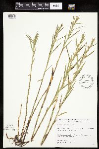 483688[1019673]Gerdes, Lynden; et al. 29011998-07-09 United States, Minnesota, Cook, T64N R03E S03SWNW. Cook County; Superior National Forest, Little John Lake.;Superior National Forest;064N;03E;3, 48.057476 -90.04601 |
MIN:Plants | 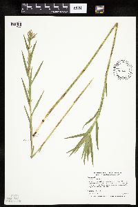 454607[1019637]Myhre, K. 68701997-07-08 United States, Minnesota, Carlton, Carlton County ... Cole Lake. Located 2 miles southwest of the town of Wright. Plants occur along the northwest bays of lake. T48N R21W SE1/4 of NE1/4 of Sec 7. 048N 21W 7, 46.658395 -93.053682 |
MIN:Plants | 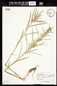 473381[1019725]Lee, Michael MDL18601997-07-22 United States, Minnesota, Stearns, Stearns Co.; Birch Lakes State Forest 4 miles south-southwest of Grey Eagle; T127N R33W NW1/4 of SW1/4 of NE1/4 Sec. 36;Birch Lakes State Forest;127N;33W;36, 45.766948 -94.777658 |
MIN:Plants | 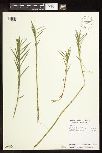 910479[1102493]Loso, Stephanie; et al. 15592006-08-15 United States, Minnesota, Cass, County: Cass, Lake ID: 11041300, Lake: Ten Mile...T140, R30W, Sec6, Southeast shore of Long Bay...DNR Site # 4 - 14;Foothills State Forest;140N;30W;06, 46.972471 -94.522077 |
MIN:Plants | 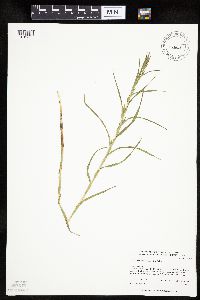 477663[1019638]Whitfeld, T.J.S. 2622001-07-28 United States, Minnesota, Kandiyohi, Sibley State Park. Kandiyohi County ... Sibley State Park. 1/2 mile east of County 48; 1/4 mile south of State Hwy. 9 ... T 122 N R 35 W SW1/4 of SW1/4 of SE1/4 of Section 35. 122N 35W 35, 45.332937 -95.039883 |
MIN:Plants | 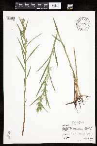 904369[1019704]Gerdes, Lynden 54432007-06-27 United States, Minnesota, Itasca, Chippewa National Forest / Leech Lake Indian Reservation. T146N R29W S17 NESE Itasca County ... Leech Lake Reservation. Chippewa National Forest. Bowstring State Forest. Approximately 5.30 miles SE of Pennington, MN and 0.41 miles north of the Third River Road (FR 2171) ... NAD 83 / 396552 / 5257602. 146N 29W 17, 47.4636111 -94.3725 |
MIN:Plants | 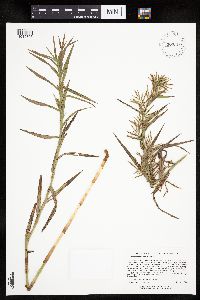 907209[1019706]Lee, Michael MDL39062004-09-29 United States, Minnesota, Otter Tail, Folden Woods Marsh Wildlife Management Area. Ottertail County...Folden Woods State Wildlife Management Area, five miles southwest of Almora...on the east side of Snow Lakes...T132N R38W NW1/4 of SE1/4 Sec. 34. 132N 38W 34, 46.202041 -95.449888 |
MIN:Plants | 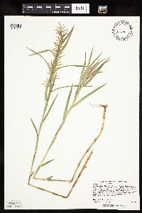 262010[1019728]Lee, Michael MDL22401998-07-08 United States, Minnesota, Carver, Carver Co.; Marsh Lake Hunting Club 2-1/2 miles south of Victoria; T116N R24W SE1/4 of SE1/4 Sec. 26;;116N;24W;26, 44.826982 -93.672449 |
MIN:Plants | 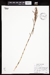 896909[1019707]Haferman, J. 3061996-09-22 United States, Minnesota, Scott, Approximately 0.25 miles east of State Highway 13 and 0.5 miles south of County Road 42. Site lies directly under transmission lines. SW of NW of section;;115N;21W;20, 44.753698 -93.369033 |
MIN:Plants | 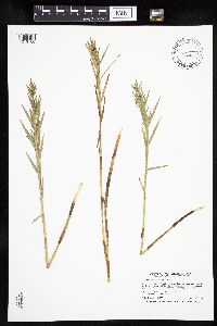 540905[1019708]Smith, Welby 262991996-08-01 United States, Minnesota, Wright, Wright County ... Nixon Lake, about 7 miles north-northeast of Annandale ... T122N R27W SE1/4 of SE1/4 of Sec 22;;122N;27W;22, 45.3569444 -94.0577778 |
MIN:Plants | 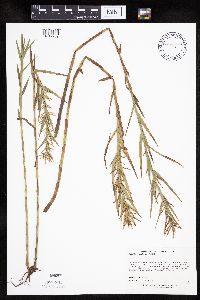 437923[1019709]Lee, Michael MDL31042001-08-21 United States, Minnesota, Lake, Lake County ... On the western shore of Balsam Lake eight miles north-northeast of Finland ... T58N R7W NW1/4 Sec. 3;Finland State Forest;058N;07W;03, 47.537227 -91.20423 |
MIN:Plants | 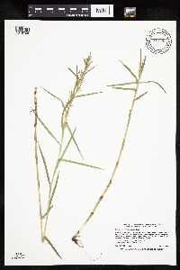 913591[1019705]Smith, Welby 230831993-07-22 United States, Minnesota, Carver, Carver County... At the northwest end of St. Joe, about 2 miles north of Chaska...T116N R23W NE1/4 of NE1/4 of Sec 7;;116N;23W;07, 44.875 -93.625 |
MIN:Plants | 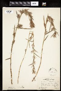 220778[1019661]Rosendahl, C.; Rydberg, P. s.n.1926-09-15 United States, Minnesota, Washington, Pine Tree Lake;;030N;21W;, 45.079652 -92.9239 |
MIN:Plants | 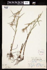 275904[1019675]Grant, Martin 30671929-08-13 United States, Minnesota, Clearwater, Itasca State Park. Morrison Lake. NW-SW Sec. 36 T143 R36.;Itasca State Park;143N;36W;, 47.19557 -95.233216 |
MIN:Plants | 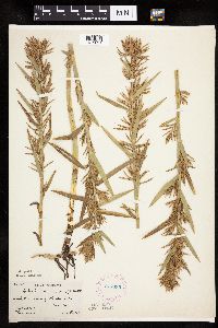 277635[1019691]Hotchkiss, N.; et al. 4451930-08-28 United States, Minnesota, Cass, About 5 mi S of Thunder Lake. Cass Co.;;140N;26W;, 46.933787 -93.965399 |
MIN:Plants | 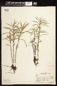 282227[1102486]Butters, F.; et al. 63521930-08-29 United States, Minnesota, Cook, Pond s of Hungry Jack Lake;Superior National Forest;064N;01W;, 48.019271 -90.447457 |
MIN:Plants | 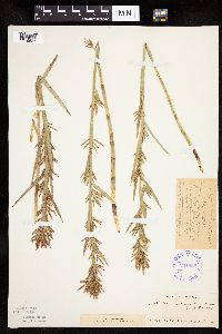 291938[1019687]Hotchkiss, N.; et al. 41071930-09-04 United States, Minnesota, Crow Wing, NE end of Molly Lake, NW of Merrifield. Crow Wing Co.;;;;, 46.48646 -94.19729 |
MIN:Plants | 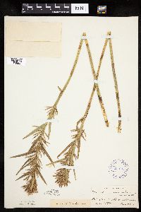 291995[1019692]Hotchkiss, N.; et al. 40751930-08-28 United States, Minnesota, Cass, Bet. Big Thunder and Roosevelt Lakes. Cass Co.;Land O Lakes State Forest;;;, 46.865286 -93.945561 |
MIN:Plants | 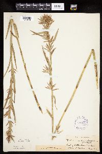 292010[1019646]Hotchkiss, N.; et al. 40371930-08-14 United States, Minnesota, Becker, E of Cotton Lake. Becker Co.;;;;, 46.846968 -95.731393 |
MIN:Plants | 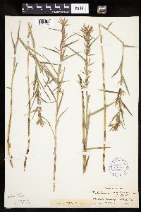 292014[1019685]Hotchkiss, N.; et al. 40201930-08-10 United States, Minnesota, Otter Tail, Star Lake Township. Otter Tail Co.;;135N;41W;, 46.499146 -95.84333 |
MIN:Plants | 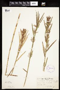 307090[1019643]Oosting, H. 291061929-08-27 United States, Minnesota, Anoka, Ham Lake.;;032N;23W;, 45.254503 -93.203833 |
MIN:Plants | 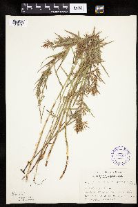 307321[1019678]Grant, Martin 66361935-08-16 United States, Minnesota, Clearwater, Itasca Park; W side Itasca Lake; SW-NE 10, T143, R36;Itasca State Park;143N;36W;10, 47.217267 -95.223034 |
MIN:Plants | 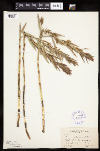 338158[1019716]Moyle, J. 22741936-08-05 United States, Minnesota, Dakota, 4 1/2 mi n of Rosemount;;N;;, 44.804579 -93.125772 |
MIN:Plants | 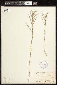 347987[1102488]Buell, Murray; Buell, Helen s.n.1933-08-01 United States, Minnesota, Anoka, Decodon Pond;Cedar Creek National History Area;034N;23W;27, 45.406779 -93.193727 |
MIN:Plants |  354027[1019697]Lakela, Olga 24161938-07-29 United States, Minnesota, Saint Louis, Shore of a small lake, Hwy. 4, at the Johnson farm, Palo.;;057N;15W;, 47.415324 -92.239713 |
MIN:Plants |  360332[1019690]Rosendahl, C.; Butters, F. 68441937-08-25 United States, Minnesota, Cass, Hattie Lake, Cass Co.;;139N;29W;, 46.848739 -94.343108 |
MIN:Plants |  360385[1102490]Lakela, Olga 40901940-08-18 United States, Minnesota, Carlton, Moosehead Lake;;046N;19W;, 46.46166 -92.740742 |
MIN:Plants |  360545[1019688]Lakela, Olga 42401940-09-08 United States, Minnesota, Saint Louis, Muddy shore of a drying lake, S of Alden Lake on Barr's Road.;;N;;, 47.061295 -92.031286 |
MIN:Plants | 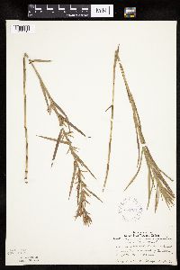 361051[1019715]Lakela, Olga 40051940-08-13 United States, Minnesota, Carlton, Chubb Lake, about 5 mi s of Carlton;;N;;, 46.634652 -92.49158 |
MIN:Plants | 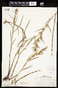 361129[1019657]Lakela, Olga 38381940-08-01 United States, Minnesota, Saint Louis, Shore of Sand Lake, on Hwy. 53.;Superior National Forest;N;;, 47.648931 -92.635203 |
MIN:Plants | 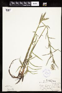 361136[1019689]Lakela, Olga 42201940-09-08 United States, Minnesota, Saint Louis, Shore of the Little Cloquet River, above the Dam on Barrs Road.;;N;;, 47.137423 -91.933768 |
MIN:Plants | 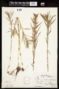 367051[1019658]Moore, John; Moore, Marjorie 103541938-08-27 United States, Minnesota, Saint Louis, NW arm of Auto Lake on its N shore.;Superior National Forest;060N;18W;, 47.674124 -92.625906 |
MIN:Plants | 369089[]Lakela, Olga 45491941-07-23 United States, Minnesota, Saint Louis, In the "Narrows" of Elbow Lake, on the road to Crane Lake.;Kabetogama State Forest;064N;18W;, 48.020818 -92.633942 |
MIN:Plants | 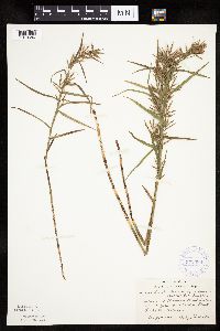 372396[1019686]Lakela, Olga 47071941-08-09 United States, Minnesota, Lake, Homestead Lake, on Tofte-Isabella Road;;N;;, 47.643859 -91.170237 |
MIN:Plants | 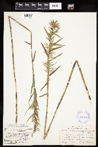 375351[1019667]Lakela, Olga 51531942-08-18 United States, Minnesota, Saint Louis, Half Moon Lake 6 mi s of Eveleth;;N;;, 47.38356 -92.51008 |
MIN:Plants | 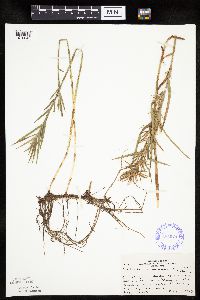 385976[1019649]Lakela, Olga 58011944-08-03 United States, Minnesota, Saint Louis, Small lake, n of Sturgeon Lake Observation Tower. St. Louis Co.;;060N;21W;, 47.675918 -92.996803 |
MIN:Plants | 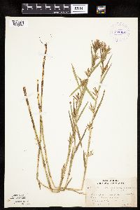 391989[1019666]Lakela, Olga 65911946-08-11 United States, Minnesota, Saint Louis, Burntside Lake, North Arm;Superior National Forest;064N;13W;00, 48.020193 -91.99005 |
MIN:Plants |  393381[1019656]Lakela, Olga 70981947-07-29 United States, Minnesota, Saint Louis, Shore of St. Louis River on Mooseline Road,;;N;;, 47.49298 -92.24844 |
MIN:Plants |  393392[1019702]Lakela, Olga 70481947-07-29 United States, Minnesota, Saint Louis, Near Skibo.;;N;;, 47.501646 -91.985085 |
MIN:Plants |  407104[1019698]Lakela, Olga 89931949-07-14 United States, Minnesota, Saint Louis, Fenske Lake, Echo Trail, N of Ely.;Superior National Forest;064N;12W;, 47.994422 -91.904667 |
MIN:Plants |  407390[1019699]Lakela, Olga 92491949-08-06 United States, Minnesota, Saint Louis, Shore of Everett Lake, Echo Trail, N of ELy.;Superior National Forest;N;;, 47.983579 -91.918711 |
MIN:Plants | 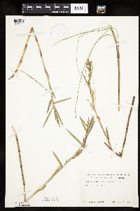 419160[1019722]Ahlgren, Clifford 4381949-07-13 United States, Minnesota, Lake, Lake Co. Sec. 20 T64 R10.;Boundary Waters Canoe Area Wilderness / Superior National Forest;064N;10W;20, 48.002267 -91.639633 |
MIN:Plants | 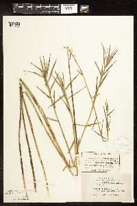 420727[1102487]Lakela, Olga 116001950-08-21 United States, Minnesota, Saint Louis, Shore of Crooked Lake, near Curtain Falls;Boundary Waters Canoe Area Wilderness / Superior National Forest;066N;12W;, 48.186787 -91.869968 |
MIN:Plants | 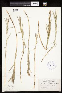 421049[1019695]Lakela, Olga 113531950-08-13 United States, Minnesota, Saint Louis, Rose Lake, 30 mi. N of Duluth.;;N;;, 47.109863 -92.416602 |
MIN:Plants | 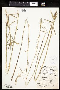 421662[1019669]Ahlgren, Clifford 10471950-08-22 United States, Minnesota, Saint Louis, Bay 1/4 mi SW of Curtain Falls, Crooked Lake;Boundary Waters Canoe Area Wilderness / Superior National Forest;066N;12W;, 48.186787 -91.869968 |
MIN:Plants | 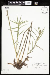 428172[1019635]Smith, Welby 188951991-06-21 United States, Minnesota, Aitkin, Hill River State Forest. Aitkin Co.; along the N side of Washburn Lake, about 6 mi E of Hill City; T52N R25W NW1/ Aitkin Co.; along the N side of Washburn Lake, about 6 mi E of Hill City; T52N R25W NW1/4 of SW1/4 of Sec 24. 052N 25W 24, 46.980278 -93.4599991 |
MIN:Plants | 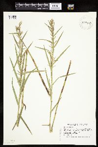 430640[1019628]Smith, Welby 194161991-07-10 United States, Minnesota, Koochiching, Koochiching State Forest. Koochiching Co.; On the north side of Moose Lake, about 6 miles east of Little Fork; Koochiching Co.; On the north side of Moose Lake, about 6 miles east of Little Fork; T 68N R 24W SE1/4 of SE1/4 of Sec 9. 068N 24W 9, 48.396215 -93.431487 |
MIN:Plants | 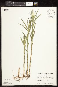 439903[1102489]Smith, Welby 143151988-06-24 United States, Minnesota, Kanabec, Kanabec Co. At the NW end of Pomroy Lake, about 6 mi N of Quamba. NE1/4 SW1/4 sec 24, T41N R23W;;141N;23W;24, 46.0155563 -93.1944427 |
MIN:Plants | 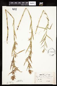 443079[1019700]Lakela, Olga 137191951-09-03 United States, Minnesota, Saint Louis, Shore of Esquagama Lake, 6 mi. S of Biwabik.;;N;;, 47.467001 -92.356147 |
MIN:Plants | 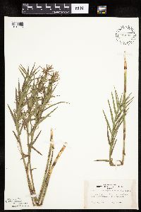 443204[1019663]Lakela, Olga 138181951-09-14 United States, Minnesota, Saint Louis, Echo Lake, on Crane Lake Road; north St. Louis Co.;Superior National Forest;066N;17W;, 48.193023 -92.519333 |
MIN:Plants | 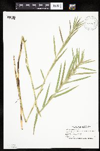 444407[1019729]Smith, Welby 196511991-07-17 United States, Minnesota, Itasca, Scenic State Park. Itasca Co.; Scenic State Park, about 4.5 miles southeast of Bigfork; Coon Lake (west side). Itasca Co.; Scenic State Park, about 4.5 miles southeast of Bigfork; Coon Lake (west side). T 60N R 25W SE1/4 of NW1/4 of Sec 6. 060N 25W 6, 47.7166672 -93.5716629 |
MIN:Plants | 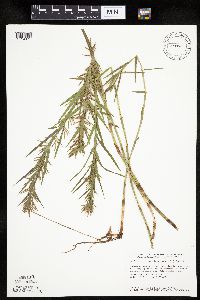 455962[1019674]Smith, Welby 147001988-08-04 United States, Minnesota, Benton, Wisneski Wildlife Area. Benton County...Wisneski State Wildlife Management Area; about 5 miles due east of Rice. SE1/4 SE1/4 section 30, T 38N R 30W. 038N 30W 30, 45.7533333 -94.1166667 |
MIN:Plants | 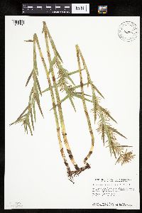 460885[1019730]Smith, Welby 145991988-07-25 United States, Minnesota, Pine, Nemadji State Forest. Pine County...Along the west shore of Pickeral Lake, about 5 miles south-southwest of Holyoke...SE1/4 SW1/4 section 1, T 45N R 17W. 045N 17W 1, 46.4047222 -92.4394444 |
MIN:Plants | 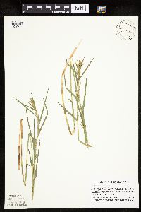 477979[1019710]Boe, J.; Dahle, R.; Butler, Cindy 980708101998-07-08 United States, Minnesota, Aitkin, Aitkin Co.; Little Dam Lake northeast of Dam Lake & <.5 mile west of Rice Lake National Wildlife Refuge; T47N R25W NW1/4 Aitkin Co.; Little Dam Lake northeast of Dam Lake & <.5 mile west of Rice Lake National Wildlife Refuge; T47N R25W NW1/4 of NE1/4 of Sec 36. 047N 25W 36, 46.512415 -93.442626 |
MIN:Plants | 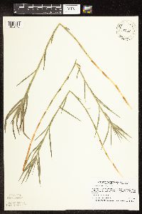 477980[1102478]Boe, J.; Butler, Cindy 980623021998-06-23 United States, Minnesota, Aitkin, Aitkin Co.; Little Prairie Lake in Savanna State Forest east of Savanna Portage State Park; T50N R22W E1/2 of Sec 15;Savanna State Forest;050N;22W;15, 46.817008 -93.113765 |
MIN:Plants | 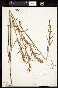 491737[1019683]Lakela, Olga 169301953-09-02 United States, Minnesota, Saint Louis, Trout Lake, n of Vermilion Lake;Boundary Waters Canoe Area Wilderness / Superior National Forest;N;;, 47.96483 -92.317289 |
MIN:Plants | 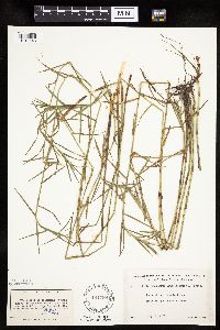 491799[1019648]Lakela, Olga 165921953-08-06 United States, Minnesota, Saint Louis, Bay, Lac La Croix, s of Lac La Croix Resort;Boundary Waters Canoe Area Wilderness / Superior National Forest;N;;, 48.335852 -92.124151 |
MIN:Plants | 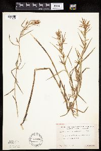 492801[1019668]Lakela, Olga 171151953-09-05 United States, Minnesota, Saint Louis, Trout Lake, n shore n of Vermilion Lake;Boundary Waters Canoe Area Wilderness / Superior National Forest;N;;, 47.96483 -92.317289 |
MIN:Plants | 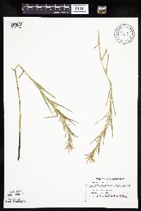 518964[1019627]Boe, J.; et al. 940822031994-08-22 United States, Minnesota, Cass, Cass County...Nushka Lake...T145N R27W NE1/4 of SE1/4 of Sec 33;Chippewa National Forest / Leech Lake Indian Reservation;145N;27W;33, 47.332682 -94.105632 |
MIN:Plants | 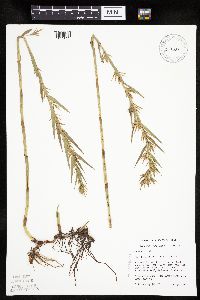 519327[1019629]Mensing, D. 95-28041995-08-08 United States, Minnesota, Carlton, Carlton Co, T48N R17W NW1/4 of the SW1/4 of S35; Hay Lake;;048N;17W;35, 46.598228 -92.459506 |
MIN:Plants | 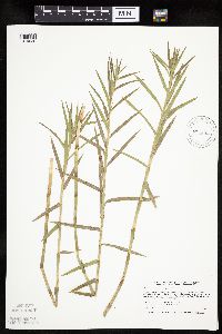 520678[1019636]Smith, Welby 211631992-07-31 United States, Minnesota, Le Sueur, Le Sueur Co.; at the S end of the Fish Lake, about 2 miles N of Elysian; T109N R24W SE1/4 of SE1/4 of Sec 23;;109N;24W;23, 44.2272224 -93.6699982 |
MIN:Plants | 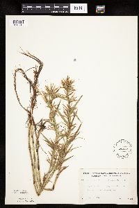 526089[1019719]Lakela, Olga 190461955-08-03 United States, Minnesota, Saint Louis, Shores of the river, the outlet from Johnson's Lake to Namakan Lake.;Voyageurs National Park;N;;, 48.370281 -92.608053 |
MIN:Plants | 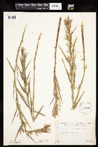 526105[1019659]Lakela, Olga 191221955-08-09 United States, Minnesota, Saint Louis, In a small lake S of Gilbert.;;N;;, 47.434966 -92.451859 |
MIN:Plants | 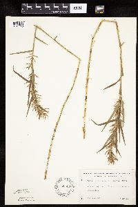 526683[1019645]Lakela, Olga 182431954-08-14 United States, Minnesota, Saint Louis, Turtle River, S of Friday Bay, Crooked Lake.;Boundary Waters Canoe Area Wilderness / Superior National Forest;;;, 48.167528 -91.806553 |
MIN:Plants | 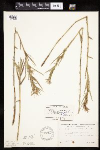 526910[1019684]Lakela, Olga 179821954-07-24 United States, Minnesota, Saint Louis, St. Louis County...Moose Lake at the portage from Gun Lake, N of Ely, Superior National Forest.;Boundary Waters Canoe Area Wilderness / Superior National Forest;065N;12W;13, 48.114818 -91.809779 |
MIN:Plants | 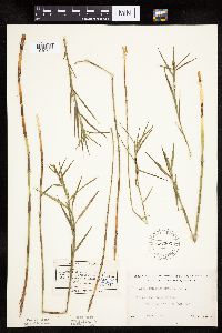 527303[1019703]Lakela, Olga 175481954-07-13 United States, Minnesota, Saint Louis, Tamarack River, W end of Burntside Lake, Ely.;Superior National Forest;063N;13W;36, 47.90238 -92.069539 |
MIN:Plants | 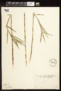 527369[1102484]Lakela, Olga 177421954-07-03 United States, Minnesota, Saint Louis, Dark Lake s of Iron Lake;Boundary Waters Canoe Area Wilderness / Superior National Forest;066N;13W;11, 48.211941 -91.965085 |
MIN:Plants | 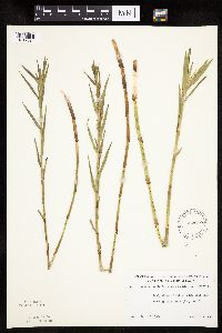 532610[1019694]Lakela, Olga 203741956-07-10 United States, Minnesota, Saint Louis, Shore of Island Lake, W side S of Hibbing, Hwy. 73.;;055N;21W;, 47.239418 -93.002014 |
MIN:Plants | 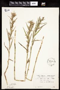 532683[1019644]Lakela, Olga 206751956-08-07 United States, Minnesota, Saint Louis, St. Louis County...Between Bullet Lakes, N of Ely.;Boundary Waters Canoe Area Wilderness / Superior National Forest;065N;12W;12, 48.12918 -91.809522 |
MIN:Plants | 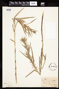 536275[1019679]Bennett, H. s.n.1947-08-02 United States, Minnesota, Clearwater, Floating [Bog] Bay - Itasca State Park;Itasca State Park;143N;36W;, 47.19557 -95.233216 |
MIN:Plants | 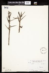 539612[1019693]Krefting, L. 691937-07-00 United States, Minnesota, Cook, East Pope Lake, Rosebush Twp;Superior National Forest;065N;02W;, 48.086772 -90.580816 |
MIN:Plants | 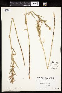 542913[1019701]Lakela, Olga 221081957-08-19 United States, Minnesota, Lake, Stony River, Hwy. 1.;Superior National Forest;N;;, 47.68778 -91.640301 |
MIN:Plants | 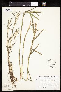 543017[1019714]Lakela, Olga; Davidson, Donald 216201957-07-25 United States, Minnesota, Lake, Lake County...Phoebe River at the bridge on Tomahawk Trail, eastern Lake Co.;Boundary Waters Canoe Area Wilderness / Superior National Forest;063N;06W;00, 47.933219 -91.087921 |
MIN:Plants | 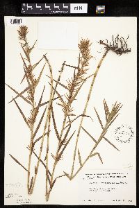 550176[1019647]Moore, John 221251954-09-16 United States, Minnesota, Sherburne, W of Eagle Lake;;N;;, 45.38719 -93.744622 |
MIN:Plants | 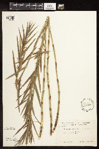 568807[1102492]Moore, John 252881960-09-21 United States, Minnesota, Isanti, Along the W shore of Fish Lake.;Cedar Creek National History Area;034N;23W;, 45.428063 -93.203997 |
MIN:Plants | 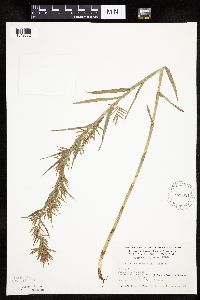 575051[1019682]Wertman, Freida 2801960-08-21 United States, Minnesota, Anoka, Cedar Creek National History Area. Cedar Creek Natural History Area; Fish Lake, W side; Sec 26, County Road 76; Athens Twp. Sect 26; Coordinates 878.9-2212 Cedar Creek Natural History Area; Fish Lake, W side; Sec 26, County Road 76; Athens Twp. Sect 26; Coordinates 878.9-2212.6. 034N 23W 26, 45.406901 -93.173147 |
MIN:Plants | 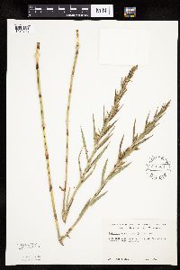 576802[1019723]Isaak, Daniel 51960-07-29 United States, Minnesota, Isanti, Horseshoe Lake. Sec. 2 and 11, T34 R22.;;034N;22W;, 45.427323 -93.081077 |
MIN:Plants | 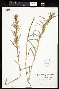 607594[1019662]Westkaemper, Remberta s.n.1967-08-00 United States, Minnesota, Stearns, Stearns Co.; island in Island Lake, Collegeville;;124N;29W;, 45.543642 -94.322053 |
MIN:Plants | 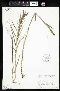 611450[1019681]Lammers, Roberta s.n.1968-08-17 United States, Minnesota, Isanti, SE of Beckman Lake, Cedar Creek Natural History Area;Cedar Creek National History Area;034N;23W;, 45.428063 -93.203997 |
MIN:Plants | 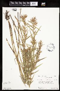 616822[1019652]Moore, John; Moore, Marjorie 4731969-09-02 United States, Minnesota, Crow Wing, E shore of Chandler Lake.;Crow Wing Natural Area;044N;28W;, 46.27899 -93.863336 |
MIN:Plants | 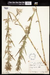 618898[1019672]Lehnert, W. s.n.1958-08-10 United States, Minnesota, Anoka, W of Moore's Lake;;030N;24W;, 45.080985 -93.255535 |
MIN:Plants | 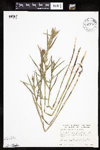 669835[1019718]Wheeler, Gerald s.n.1975-07-07 United States, Minnesota, Saint Louis, 3 mi. SE of the jct. of the main road to Dunka Mine (Erie Mining Co.) and the Reserve Mining Co. railroad tracks; near B 3 mi. SE of the jct. of the main road to Dunka Mine (Erie Mining Co.) and the Reserve Mining Co. railroad tracks; near Babbitt.. N , 47.65706 -91.81832 |
MIN:Plants | 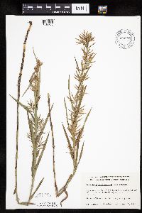 669864[1019736]Wheeler, Gerald s.n.1974-08-08 United States, Minnesota, Sherburne, NW side of Clitty Lake; SE of St. Cloud on Hwy. 10 (ca. 5 mi. from St. Cloud).;;N;;, 45.415596 -93.885152 |
MIN:Plants | 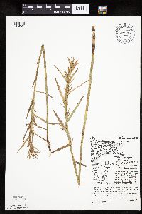 670196[1019724]Hansen, B.; Hansen, JoAnn 36551975-08-28 United States, Minnesota, Cook, 12 mi. N of Lutsen at the outlet of Tait Lake (SE most end). Forest around lodge area. T62N, R3W, Sec. 34.;Superior National Forest;062N;03W;34, 47.810157 -90.692057 |
MIN:Plants | 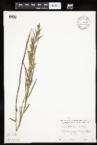 672627[1019737]Wheeler, Gerald s.n.1973-08-19 United States, Minnesota, Sherburne, Ca. 1 mi. SE of Santiago. Adjacent to a pond.;;035N;28W;, 45.516 -93.820644 |
MIN:Plants | 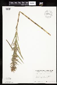 672634[1019738]Wheeler, Gerald s.n.1973-08-16 United States, Minnesota, Sherburne, Sherburne National Wildlife Refuge; W shore of Rice Lake.;Sherburne National Wildlife Refuge;035N;27W;, 45.516017 -93.696361 |
MIN:Plants | 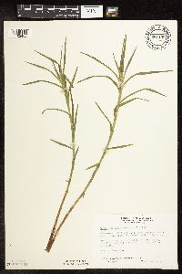 687158[1102485]Wheeler, Gerald; Glaser, Paul 15861977-06-04 United States, Minnesota, Itasca, Coll. Site No. 42; SW1/4 SE1/4 Sec. 18 T57N R25W; approx. 12.5 mi N-NW of Grand Rapids; Coll. Site No. 42;Chippewa National Forest;057N;25W;18, 47.421972 -93.567645 |
MIN:Plants | 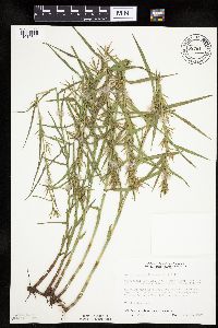 687611[1019641]Wheeler, Gerald; Glaser, Paul 20561977-07-12 United States, Minnesota, Itasca, SW1/4 NE1/4 Sec.6 T56N R26W; approx. 10 mi n-nw of Grand Rapids; sedge meadow located between Bass Lake and Deer Lake.;;056N;26W;6, 47.3631 -93.692249 |
MIN:Plants | 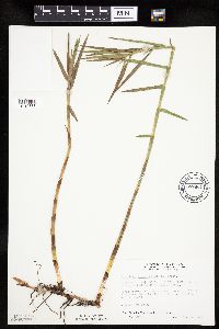 687661[1019633]Wheeler, Gerald; Glaser, Paul 21061977-07-15 United States, Minnesota, Itasca, Coll. Site No. 119; SW1/4 NW1/4 Sec. 13 T54N R27W; approx. 9.5 mi SW of Grand Rapids; marash near the edge of Little Sis Coll. Site No. 119; SW1/4 NW1/4 Sec. 13 T54N R27W; approx. 9.5 mi SW of Grand Rapids; marash near the edge of Little Sisebakwet Lake (ne shore). 054N 27W 13, 47.159756 -93.714153 |
MIN:Plants | 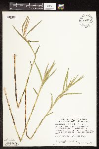 698173[1102477]Wheeler, Gerald; Glaser, Paul 29731978-06-20 United States, Minnesota, Beltrami, S1/2 SE1/4 Sec. 32 T156N R32W; approx. 15.5 mi nw of the Waskish Airport; Ovoid Islands Area; Hilman Lake; on the southe S1/2 SE1/4 Sec. 32 T156N R32W; approx. 15.5 mi nw of the Waskish Airport; Ovoid Islands Area; Hilman Lake; on the southern edge of the lake; coll. site no. 13. 156N 32W 32, 48.288497 -94.784577 |
MIN:Plants | 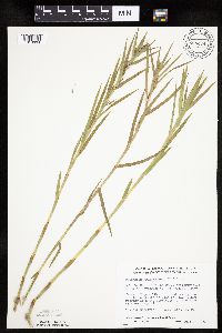 698474[1019634]Wheeler, Gerald; Glaser, Paul 32751978-07-16 United States, Minnesota, Beltrami, SW1/4 SW1/4 Sec 15 T156N R32W; approx. 16 mi NW of the Waskish Airport; W edge of Ovoid Islands Area; about 1 mi sw of C SW1/4 SW1/4 Sec 15 T156N R32W; approx. 16 mi NW of the Waskish Airport; W edge of Ovoid Islands Area; about 1 mi sw of Camp No. II.; Coll. Site No. 70. 156N 32W 15, 48.332043 -94.742064 |
MIN:Plants | 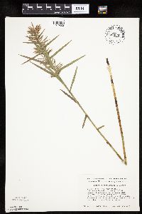 704609[1019660]Smith, Welby 16601979-08-16 United States, Minnesota, Wabasha, 150 Meters due W of Co. Rd. 84.;;109N;09W;18, 44.243599 -91.939111 |
MIN:Plants | 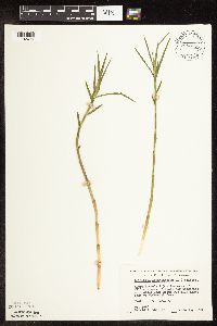 708875[1102476]Wheeler, Gerald 38631979-06-13 United States, Minnesota, Pine, Pine Co. Approx. 2.5 mi e of Willow River; small lake about 0.5 mi ne of McCormick Lake; T44N R19W Sec.5;General C C Andrews State Forest;044N;19W;5, 46.324244 -92.772254 |
MIN:Plants |  709831[1019717]Wheeler, Gerald 48491979-09-07 United States, Minnesota, Itasca, Approx. 8.5 mi n-nw of Grand Rapids; T56N R26W Sec.1;;056N;26W;1, 47.362785 -93.587218 |
MIN:Plants |  722611[1019642]Lustig, K. 7571979-07-18 United States, Minnesota, Anoka, Anoka County...Boot Lake SNA: 18 mi. SE of Cambridge; Sec. 17, 18, 19, 20, T33N, R22W;Boot Lake Scientific Natural Area;033N;22W;00, 45.340658 -93.081463 |
MIN:Plants |  745958[1019720]Smith, Welby 57571981-09-13 United States, Minnesota, Wright, Wright Co.; Cedar Lake, about 5 mi. SW of Monticello. NW1/4 NE1/4 Sec. 30, T121N R25W.;;121N;25W;30, 45.259775 -93.880013 |
MIN:Plants |  759188[1019727]Smith, Welby 70281982-07-31 United States, Minnesota, Wright, Wright Co.; about 6 mi S-SE of Clearwater; NW1/4 NW1/4 section 31, T122N R26W;;122N;26W;31, 45.33288 -94.003872 |
MIN:Plants | 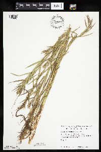 774137[1019696]Monson, Paul 52501982-08-11 United States, Minnesota, Saint Louis, Voyageurs National Park. R19W, T69N, NE1/4, S18. Agnes Lake, Kabetogama Peninsula. SW end of lake.;Voyageurs National Park;069N;19W;18, 48.462279 -92.820057 |
MIN:Plants | 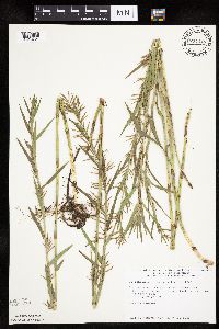 774448[1019721]Monson, Paul 56971983-07-30 United States, Minnesota, Saint Louis, Voyageurs National Park. R18W, T68N, SW1/4, S4. Nett Lake. N end of the lake.;Voyageurs National Park;068N;18W;4, 48.40461 -92.661405 |
MIN:Plants | 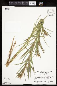 780387[1019735]Ownbey, Gerald 70331985-07-18 United States, Minnesota, Aitkin, Aitkin County ... Just NE of Dam Lake, Kimberly Twp. In and un-named lake.;;047N;25W;36, 46.512415 -93.442626, 373m |
Google Map
Google Maps is a web mapping service provided by Google that features a map that users can pan (by dragging the mouse) and zoom (by using the mouse wheel). Collection points are displayed as colored markers that when clicked on, displays the full information for that collection. When multiple species are queried (separated by semi-colons), different colored markers denote each individual species.