University of Minnesota
http://www.umn.edu/
612-625-5000
http://www.umn.edu/
612-625-5000
Minnesota Biodiversity Atlas
Bell Museum
Dataset: MIN-Plants
Taxa: Fraxinus
Search Criteria: excluding cultivated/captive occurrences
Bell Museum plants | |
 MIN:Plants |  Fraxinus pennsylvanica Marshall 497606[1033811]Smith, Welby 286932000-07-11 United States, Minnesota, Aitkin, Aitkin County ...Rice Lake National Wildlife Refuge; about 5 miles S-SW of McGregor...T47N R24W SE1/4 of SW1/4 of Sec 23;Rice Lake National Wildlife Refuge;047N;24W;23, 46.5388889 -93.3422222 |
MIN:Plants |  Fraxinus pennsylvanica Marshall 509921[1034007]Smith, Welby 287742000-07-21 United States, Minnesota, Pine, Pine County ... St. Croix State Park; where Sand Creek joins the St. Croix River ...T 40N R 18W SE1/4 of SW1/4 of Sec 19;Saint Croix State Park;040N;18W;19, 45.9322222 -92.64 |
MIN:Plants |  Fraxinus pennsylvanica Marshall 511735[1033958]Smith, Welby 290612000-08-31 United States, Minnesota, Anoka, Carlos Avery Wildlife Management Area. Anoka County ... Carlos Avery State Wildlife Management Area. On the west side of Linwood lake, about 4.5 miles west of Wyoming (town). T 33N R 22W SE1/4 of NW1/4 of Sec 16. 033N 22W 16, 45.3491667 -93.0969444 |
MIN:Plants |  Fraxinus pennsylvanica Marshall 904559[1034031]Smith, Welby 257051995-06-27 United States, Minnesota, Mille Lacs, Father Hennepin State Park. Mille Lacs County ... Father Hennepin State Park. On the south shore of Mille Lacs Lake, about one mile west- northwest of the town of Isle ... T42N R25W NE1/4 of SW1/4 of Sec 4. 042N 25W 4, 46.1477778 -93.4972222 |
MIN:Plants |  Fraxinus pennsylvanica Marshall 509708[1033967]Smith, Welby 286682000-07-09 United States, Minnesota, Ramsey, Ramsey County ... Swede's Hollow City Park, in St. Paul ... T29N R22W SE1/4 of NW1/4 of Sec 32 T 29N R 22W SE1/4 of NW1/4 of Sec 32. 029N 22W 32, 44.9577778 -93.0763889 |
MIN:Plants | 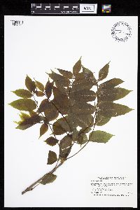 Fraxinus nigra Marshall 436824[1033753]Smith, Welby 167542000-05-30 United States, Minnesota, Olmsted, Whitewater Wildlife Management Area. Olmsted County...In the Whitewater State Wildlife Management Area, about 4 miles southeast of Plainview...Whitewater River...T 107N R 11W SE1/4 of NW1/4 of Sec 3. 107N 11W 3, 44.1016667 -92.1338889 |
MIN:Plants | 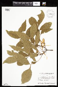 Fraxinus pennsylvanica Marshall 920661[1033790]Smith, Welby 117891986-06-14 United States, Minnesota, Olmsted, Olmsted County...Oxbow County Park, about three miles north of Byron...Zumbro River...NW1/4 NW1/4 section 17 T107N R15W;Oxbow County Park;107N;15W;17, 44.0769444 -92.6538889 |
MIN:Plants | 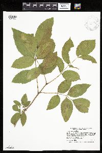 Fraxinus pennsylvanica Marshall 913178[1033777]Smith, Welby 227501993-07-08 United States, Minnesota, Rock, Blue Mounds State Park. Rock County...Blue Mounds State Park, about 4 miles north-northeast of Luverne...T 103N R 45W NW1/4 of SW1/4 of Sec 25 of NW1/4 of Sec 24. 103N 45W 25, 43.6944444 -96.1888889 |
MIN:Plants | 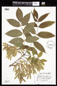 Fraxinus nigra Marshall 429085[1033634]Smith, Welby 271481998-05-26 United States, Minnesota, Pine, Banning State Park. Pine County ... Banning State Park, about 2.5 mi north-northeast of Sandstone ... along the Kettle River ... T 43N R 20W SW1/4 of NE1/4 of Sec 35. 043N 20W 35, 46.1658333 -92.8327778 |
MIN:Plants |  Fraxinus nigra Marshall 474185[1033685]Moore, John 6131971-09-24 United States, Minnesota, Sherburne, SE1/4 S-14 Santiago Tshp. [ Sherburne Wildlife Refuge];Sherburne National Wildlife Refuge;035N;27W;14, 45.52313 -93.66503 |
MIN:Plants |  Fraxinus pennsylvanica Marshall 913237[1033778]Smith, Welby 242591994-07-02 United States, Minnesota, Polk, Polk County... On Nancy Sather's farm, about 1.25 miles west of Polk-Clearwater County line... T147N R39W NE1/4 of SE1/4 of Sec 11. 147N 39W 11, 47.5633333 -95.5802778 |
MIN:Plants |  Fraxinus nigra Marshall 916532[1033679]Smith, Welby 223061993-06-03 United States, Minnesota, Sibley, Vale Wildlife Management Area. Sibley County ... Vale State Wildlife Management Area; in the valley of High Island Creek, about 2.5 miles southwest its confluence with the Minnesota River ... T113N R26W NE1/4 of SW1/4 of Sec 27. 113N 26W 27, 44.5625 -93.9427778 |
MIN:Plants |  Fraxinus nigra Marshall 899087[1033659]Myhre, K. 19381992-05-26 United States, Minnesota, Cass, Cass County...Located on the west side of Jack Lake...T 141N R 30W NE1/4 of SE1/4 of Sec 3;Chippewa National Forest / Leech Lake Indian Reservation;141N;30W;03, 47.05941 -94.45966 |
MIN:Plants |  Fraxinus pennsylvanica Marshall 909130[1034009]Smith, Welby 247431994-07-14 United States, Minnesota, Koochiching, Koochiching State Forest. Koochiching County...Along the Big Fork River, about 15 miles south of the town of Big Fork...T 63N R 27W NW1/4 of NE1/4 of Sec 14. 063N 27W 14, 47.9538889 -93.755 |
MIN:Plants |  Fraxinus nigra Marshall 899483[1033739]Smith, Welby 292432001-08-01 United States, Minnesota, Washington, William O'Brien State Park. Washington County...William O'Brien State Park, about 1.5 miles north of Marine on St. Croix...T32N R19W NW1/4 of NE1/4 of Sec 31. 032N 19W 31, 45.2233333 -92.7613889 |
MIN:Plants |  Fraxinus pennsylvanica Marshall 509645[1033760]Smith, Welby 288282000-07-26 United States, Minnesota, Aitkin, Aitkin County ... Savanna Portage State Park; about one mile west of Shumway Lake ... T50N R22W SW1/4 of SE1/4 of Sec 7;Savanna Portage State Park;050N;22W;07, 46.8286111 -93.1744444 |
MIN:Plants |  Fraxinus pennsylvanica Marshall 436774[1034046]McNaughton, Lynn 1542003-09-23 United States, Minnesota, Waseca, Maplewood Park: Waseca County ... SE1/4 of SW1/4 of Sect. 9, T107N, R22W.;Maplewood County Park;107N;22W;09, 44.08766 -93.47676 |
MIN:Plants | 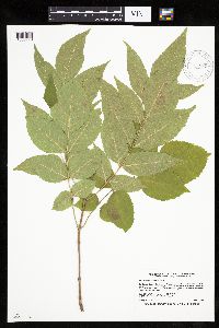 Fraxinus pennsylvanica Marshall 913182[1033776]Smith, Welby 227321993-07-02 United States, Minnesota, Becker, Dunton County Park. Becker County...Dunton County Park, about 3 miles southwest of Detroit Lakes...northwest end of Muskrat Lake... T 138N R 41W SE1/4 of NE1/4 of Sec 8. 138N 41W 8, 46.7825 -95.8816667 |
MIN:Plants | Fraxinus caroliniana Miller 477472[]US Nat. Arboretum staff 1491978-00-00 United States, Virginia, Surry, Surry Co. |
MIN:Plants | 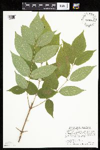 Fraxinus pennsylvanica Marshall 462308[1033982]Smith, Welby 288932000-08-02 United States, Minnesota, Goodhue, Frontenac State Park. Goodhue County ... Frontenac State Park, about 2 miles N-NE of Frontenac (town) ... on NE-facing bluff overlooking the Mississippi River ... T112N R13W NW1/4 of SE1/4 of Sec 2. 112N 13W 2, 44.5341682 -92.3349991 |
MIN:Plants | 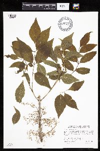 Fraxinus pennsylvanica Marshall 898324[1033957]Smith, Welby 278201999-05-28 United States, Minnesota, Marshall, Marshall County...Along the Middle River on the west side of Newfolden...T156N R44W NE1/4 of NW1/4 of Sec 8;;156N;44W;08, 48.3563889 -96.3380556 |
MIN:Plants |  Fraxinus pennsylvanica Marshall 477430[1033805]Smith, Welby 205861992-06-25 United States, Minnesota, Redwood, Redwood County ... In Alexander Ramsey city park in Redwood Falls; in the Redwood River Valley ... T113N R36W NW1/4 of SE1/4 of Sec 36. 113N 36W 36, 44.5480537 -95.1244431 |
MIN:Plants | 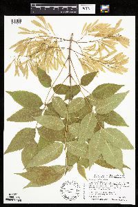 Fraxinus pennsylvanica Marshall 509611[1033756]Smith, Welby 271801998-06-01 United States, Minnesota, Mille Lacs, Kunkel Wildlife Management Area. Mille Lacs County ... Kunkel State Wildlife Management Area, about 4.5 miles west of Princeton ... T 36N R 27W SW1/4 of NE1/4 of Sec 26. 036N 27W 26, 45.5841667 -93.6638889 |
MIN:Plants | 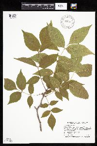 Fraxinus pennsylvanica Marshall 916910[1034047]Smith, Welby 223411993-06-08 United States, Minnesota, Carver, Carver County...Carver Park Reserve; about 5 miles west of Chanhassen...T 116N R 24W SE1/4 of NE1/4 of Sec 11;Carver Park Reserve County Park;116N;24W;11, 44.8716667 -93.6644444 |
MIN:Plants | 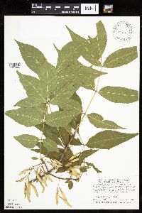 Fraxinus pennsylvanica Marshall 480638[1033980]Smith, Welby 286622000-07-08 United States, Minnesota, Wright, Wright County ... On the east side of Clearwater Lake, about 3 miles N-NE of Annandale ... T121N R27W NW1/4 of SW1/4 of Sec 9. 121N 27W 9, 45.3011093 -94.0911102 |
MIN:Plants | 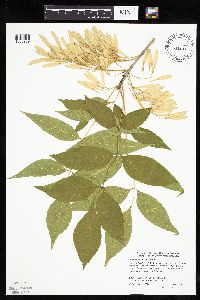 Fraxinus pennsylvanica Marshall 454825[1033969]Smith, Welby 272141998-06-06 United States, Minnesota, Anoka, Lamprey Pass Wildlife Management Area. Anoka County ... Lamprey Pass State Wildlife Management Area, about 2 miles southwest of Forest Lake (town) ... T32N R22W SW1/4 of NE1/4 of Sec 13. 032N 22W 13, 45.2619444 -93.0294444 |
MIN:Plants | 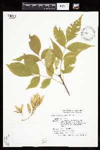 Fraxinus pennsylvanica Marshall 435721[1033953]Smith, Michael 2961996-08-28 United States, Minnesota, Koochiching, Voyageurs National Park. Koochiching County ... Plot name: Voya 32 DNR # 5790 [this locale is not within the Park];Koochiching State Forest;070N;23W;, 48.5338898 -93.2241669 |
MIN:Plants |  Fraxinus pennsylvanica Marshall 477401[1033803]Smith, Welby 254881994-09-11 United States, Minnesota, Goodhue, Frontenac State Park. About one mile north-northwest of the town of Frontenac. SE1/4 of NW1/4 of secton SE1/4 of NW1/4 of sec 2. 112N 13W 2, 44.5383333 -92.3397222 |
MIN:Plants |  Fraxinus pennsylvanica Marshall 477400[1033968]Smith, Welby 225361993-06-22 United States, Minnesota, Stevens, About 6.5 miles west-northwest of Donnelly. NW1/4 of NW1/4 of section;Boekholt Grove Wildlife Management Area;126N;44W;14, 45.73 -96.17 |
MIN:Plants |  488904[1033596]Smith, Welby 155051989-06-30 United States, Minnesota, Chisago, Chisago County ... Interstate State Park in Taylors Falls, in the St. Croix Valley ... SW1/4 SE1/4 section 25, T34N R19W;Interstate State Park;034N;19W;25, 45.40474 -92.66223 |
MIN:Plants | 511376[]US Nat. Arboretum staff 1291975-00-00 United States, District of Columbia, Washington |
MIN:Plants |  Fraxinus pennsylvanica Marshall 493829[1033983]Smith, Welby 282121999-08-25 United States, Minnesota, Hubbard, Hubbard County ... About 5 miles southwest of Laporte ... T 143N R 33W SW1/4 of SW1/4 of Sec 36;Paul Bunyan State Forest;143N;33W;36, 47.1530571 -94.8111115 |
MIN:Plants |  Fraxinus pennsylvanica Marshall 480599[1033773]Smith, Welby 171021990-06-28 United States, Minnesota, Waseca, Waseca County ... At the north end of Buffalo Lake, about 3 miles south of Janesville ... T 107N R 24W NE1/4 of NE1/4 of Sec 20. 107N 24W 20, 44.065834 -93.7300034 |
MIN:Plants |  Fraxinus nigra Marshall 459526[1033658]Smith, Welby 273691998-07-10 United States, Minnesota, Otter Tail, Bluff Creek Wildlife Management Area. Otter Tail County...Bluff Creek State Wildlife Management Area, about 11 miles west of Sebeka...T136N R37W NE1/4 of NW1/4 of Sec 2. 136N 37W 2, 46.6286125 -95.3144455 |
MIN:Plants |  Fraxinus pennsylvanica Marshall 477437[1033802]Smith, Welby 288412000-07-27 United States, Minnesota, Winona, Whitewater Wildlife Management Area. Winona County ... Whitewater State Wildlife Management Area; about 5 miles SW of Weaver ... T 108N R 10W NE1/4 of NE1/4 of Sec 15. 108N 10W 15, 44.1597214 -92.0027771 |
MIN:Plants |  Fraxinus pennsylvanica Marshall 454326[1033900]Smith, Welby 287432000-07-14 United States, Minnesota, Ramsey, Ramsey County ... Battle Creek County Park, in St. Paul ... T 28N R 22W SE1/4 of SE1/4 of Sec 3;Battle Creek County Park;028N;22W;3, 44.9361115 -93.0280533 |
MIN:Plants | 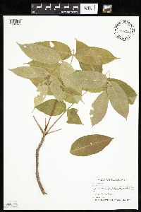 Fraxinus nigra Marshall 477286[1033655]Smith, Welby 205401992-06-24 United States, Minnesota, Brown, Boesch Wildlife Management Area. Brown County ... Boesch State Wildlife Management Area, about 3 miles northwest of New Ulm, in the Minnesota River Valley ... T 110N R 31W SW1/4 of NW1/4 of Sec 3. 110N 31W 3, 44.3624992 -94.5494461 |
MIN:Plants | 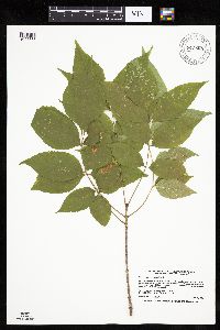 Fraxinus pennsylvanica Marshall 913888[1033833]Smith, Welby 226171993-06-29 United States, Minnesota, Swift, Swift County... In Lake Monson State Park, about 17 miles northwest of Wilmar... T121N R37W SW1/4 of NW1/4 of Sec 1;Monson Lake State Park;121N;37W;01, 45.3236111 -95.2688889 |
MIN:Plants | 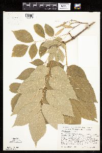 367981[1033616]Morley, T. 11101966-07-20 United States, Minnesota, Houston, Houston County...4.6 mi. S of S edge of Brownsville; T 102N, R 4W, Sec. 24.;Dorer Memorial Hardwood State Forest;102N;04W;24, 43.62315 -91.27054 |
MIN:Plants | 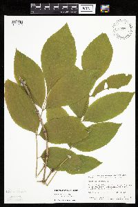 506832[1033613]Smith, Welby 129421987-06-11 United States, Minnesota, Fillmore, Root River Valley, about 3 mi SW of Peterson. SW1/4 SE1/4 of section;Dorer Memorial Hardwood State Forest;104N;09W;35, 43.76755 -91.88003 |
MIN:Plants | 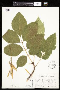 601248[1033599]Morley, T. 11101966-07-20 United States, Minnesota, Houston, Houston Co. 4.6 mi. S of S edge of Brownsville; T102N, R4W, Sec. 24.;Dorer Memorial Hardwood State Forest;102N;04W;24, 43.62315 -91.27054 |
MIN:Plants | 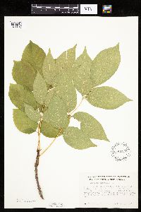 601249[1033615]Morley, T. 11111966-07-20 United States, Minnesota, Winona, Winona Co. Above hwy, 2.2 mi. S of S edge of Dakota; T105N, R4W, SE1/4 Sec. 20.;;105N;04W;20, 43.88323 -91.33121 |
MIN:Plants | 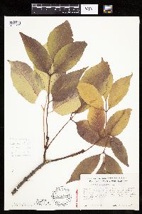 601250[1033602]Morley, T. 11121966-09-25 United States, Minnesota, Fillmore, Fillmore Co. S edge of Preston, near hilltop S of the Root River, E side of co. rd. 17. T102N, R10W, S1/4 Sec. 6 near i Fillmore Co. S edge of Preston, near hilltop S of the Root River, E side of co. rd. 17. T102N, R10W, S1/4 Sec. 6 near its center.. 102N 10W , 43.66665 -92.07947 |
MIN:Plants | 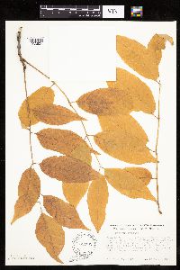 601251[1033624]Morley, T. 11131966-09-25 United States, Minnesota, Fillmore, Ca. 3 mi WNW of Wykoff. NE1/4 NE1/4 of section;;103N;13W;24, 43.7106 -92.33914 |
MIN:Plants | 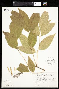 601256[1033630]Morley, T. 11151966-09-25 United States, Minnesota, Olmsted, Dorer Memorial Hardwood State Forest. Olmsted Co. About 1 mi W of Cummingsville; T105N, R12W, W1/2 Sec. 28, SE side of road, ca. 3/4 of the way up the hill f Olmsted Co. About 1 mi W of Cummingsville; T105N, R12W, W1/2 Sec. 28, SE side of road, ca. 3/4 of the way up the hill from the valley.. 105N 12W 28, 43.86938 -92.26855 |
MIN:Plants | 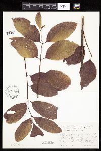 601258[1033626]Morley, T. 11161966-09-25 United States, Minnesota, Goodhue, 5 mi. S of S edge of Cannon Falls on road to Rochester, 200 yds. E of hwy. T111N, R17W, SE1/4 Sec. 8 (Leon Twp.);;111N;17W;8, 44.43501 -92.88094 |
MIN:Plants | 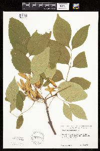 602335[1033612]Johnson, Albert s.n.1966-08-04 United States, Minnesota, Pine, Pine Co. Along Hwy. 48, SE1/4 SE1/4 Sec. 23, Ogema Twp. T41N, R17W.;;041N;17W;23, 46.01981 -92.45705 |
MIN:Plants | 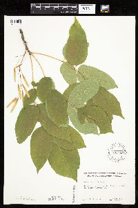 602342[1033595]Johnson, Albert s.n.1966-07-31 United States, Minnesota, Chisago, 2 mi. N of Taylors Falls on Hwy. 71.;;;;, 45.4309 -92.65222 |
MIN:Plants |  602343[1033600]Johnson, Albert s.n.1966-07-31 United States, Minnesota, Chisago, Along Hwy 16, Shafer Twp, T34N, R19W, SE1/2 Sec. 13.;;034N;19W;13, 45.43371 -92.66217 |
MIN:Plants |  602344[1033619]Johnson, Albert s.n.1966-08-24 United States, Minnesota, Pine, Pine Co. 3 mi W of the St. Croix River, Hwy. 70, T41N, Sec. 16, Rock Creek Twp.;Saint Croix State Forest;041N;17W;16, 46.03384 -92.49857 |
MIN:Plants |  603793[1033604]Moore, John; et al. 269651966-07-30 United States, Minnesota, Houston, Houston County...Bluffs of the Mississippi River, 2 mi. N of Reno;;102N;04W;, 43.63008 -91.275 |
MIN:Plants |  603833[1033608]Moore, John; et al. 272311967-09-20 United States, Minnesota, Olmsted, Olmsted County...Bluffs of the White Water River, Sec. 2, Quincy Twp.;;107N;11W;, 44.06444 -92.14639 |
MIN:Plants |  603973[1033605]Moore, John; et al. 269661966-07-30 United States, Minnesota, Houston, Houston County...Bluffs of the Mississippi River along the River Road, 2 mi. N of Reno;Dorer Memorial Hardwood State Forest;102N;04W;, 43.63008 -91.275 |
MIN:Plants |  621990[1033607]Johnson, Albert s.n.1968-09-11 United States, Minnesota, Pine, Pine Co. E side of Hwy. 35. 2 1/2 mi. N of Hinckley.;;;;, 46.04035 -92.94417 |
MIN:Plants |  621991[1033629]Johnson, Albert s.n.1966-08-04 United States, Minnesota, Pine, Pine Co. SE1/4 of SE1/4 Sec. 23, T41N, R17W, Ogema Twp.;;041N;17W;23, 46.01981 -92.45705 |
MIN:Plants |  621992[1033617]Johnson, Albert s.n.1971-09-11 United States, Minnesota, Pine, Pine Co. E side of Hwy. 35. 2 1/2 mi. N of Hinckley;;;;, 46.04035 -92.94417 |
MIN:Plants | 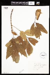 621993[1033610]Johnson, Albert s.n.1970-09-09 United States, Minnesota, Pine, Pine Co. E side of Hwy. 35. 2 1/2 mi. N of Hinckley.;;;;, 46.04035 -92.94417 |
MIN:Plants | 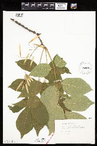 621998[1033603]Johnson, Albert s.n.1966-07-03 United States, Minnesota, Chisago, 1 1/2 mi. N of Taylors Falls on Hwy. 16;;;;, 45.4309 -92.65222 |
MIN:Plants | 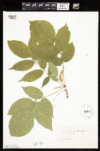 622002[1033606]Johnson, Albert s.n.1966-07-31 United States, Minnesota, Chisago, Along Hwy. 71, 2 mi. N of Taylors Falls;;;;, 45.4309 -92.65222 |
MIN:Plants | 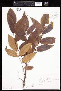 622007[1033618]Johnson, Albert s.n.1971-10-01 United States, Minnesota, Kanabec, Kanabec Co. 3 mi SW of Ogilvie, on the r.r. grade, N side of Hwy. 23. NW1/4 SW1/4 Sec. 5, T38N, R25W.;;038N;25W;5, 45.81353 -93.48305 |
MIN:Plants |  622008[1033601]Johnson, Albert s.n.1971-10-01 United States, Minnesota, Mille Lacs, Roadside, Co. 31, E edge of village of Isle. SW1/4 SW1/4 Sec. 1, T42N, R25W.;;042N;25W;1, 46.14689 -93.44215 |
MIN:Plants |  622009[1033609]Johnson, Albert s.n.1971-10-01 United States, Minnesota, Kanabec, Kanabec Co. 2 mi N of Ogilvie. NW1/4 NW1/4 Sec. 14, T39N, R25W;;039N;25W;14, 45.86832 -93.42163 |
MIN:Plants |  622010[1033598]Johnson, Albert s.n.1971-09-27 United States, Minnesota, Mille Lacs, E side of Hwy. 47 ca. 1/4 mi. N of the village of Isle. Lot 7. Sec. 35, T43N, R25W.;;043N;25W;35, 46.16125 -93.46237 |
MIN:Plants |  622012[1033614]Johnson, Albert s.n.1971-10-01 United States, Minnesota, Mille Lacs, On th N side of Hwy. 27, between Isle and Wahkon. NE1/4 SW1/4 of section;;042N;25W;09, 46.13274 -93.50455 |
MIN:Plants |  622013[1033623]Johnson, Albert s.n.1971-10-01 United States, Minnesota, Mille Lacs, Along Co. Rd. 41 NE of Isle. SW1/4 NW1/4 Sec. 36, T43N, R25W.;;043N;25W;36, 46.16108 -93.44153 |
MIN:Plants |  622014[1033625]Johnson, Albert s.n.1971-10-01 United States, Minnesota, Mille Lacs, Mille Lacs Co. Near Indian house on W side of Hwy. 169, Mille Lacs Indian Reservation. SE1/4 SE1/4 Sec. 17, T43N, R27W.;Mille Lacs Indian Reservation;043N;27W;17, 46.20704 -93.77753 |
MIN:Plants |  622015[1033631]Johnson, Albert s.n.1971-10-01 United States, Minnesota, Mille Lacs, N side of Co. Rd. 41, NE of Isle. SW1/4 of NW1/4 Sec. 35, T43N, R25W.;;;;, 46.16125 -93.46237 |
MIN:Plants |  Fraxinus pennsylvanica Marshall 622016[1033813]Johnson, Albert s.n.1971-10-01 United States, Minnesota, Mille Lacs, On railroad grade north side of Highway 23 between Milaca and Ogilvie ... NW1/4 SE1/4 Sec. 19 T38N R26W. Borgholm Twp.;;038N;26W;19, 45.77146 -93.62831 |
MIN:Plants |  622018[1033622]Johnson, Albert s.n.1971-10-01 United States, Minnesota, Mille Lacs, N side of Co. Rd. 41 NE of Isle. SW1/4 NW1/4 Sec. 35, T43N, R25W.;;043N;25W;35, 46.16125 -93.46237 |
MIN:Plants |  622042[1033611]Johnson, Albert s.n.1971-09-27 United States, Minnesota, Mille Lacs, E side of hwy. N of Isle; T42N, R25W, Sec. 2;;042N;25W;2, 46.14698 -93.46296 |
MIN:Plants |  644894[1033620]Neese, E. 11321973-12-30 United States, Minnesota, Ramsey, Ramsey Co.; Beside Lake Judy, Shoreview;;030N;23W;, 45.07917 -93.14694 |
MIN:Plants |  817415[1033628]Delaney, B. 890231989-06-15 United States, Minnesota, Isanti, Cranberry Wildlife Management Area, N border Isanti Co. SW1/4 SW1/4 Sec. 4, T37N, R24W.;;037N;24W;4, 45.72368 -93.33798 |
MIN:Plants |  831461[1033627]Cloutier, H. s.n.1943-07-20 United States, Minnesota, Itasca, Itasca Co, Coleraine, Trout Lake vicinity;;;;, 47.25722 -93.40222 |
MIN:Plants |  833532[1033597]Juhnke, C. 1431991-06-24 United States, Minnesota, Fillmore, Forestville State Park. Fillmore Co. T102N R12W Sec.20 NE NE SE; near Mystery Cave II;Forestville State Park;102N;12W;20, 43.62366 -92.2986 |
MIN:Plants |  Fraxinus pennsylvanica Marshall 834842[1033791]Juhnke, C. 366 CMJ1993-09-04 United States, Minnesota, Fillmore, Along bridge on E bank of South Branch of Root River near Mystery Cavea entrance I. SE SE SE of section;Forestville State Park;102N;12W;19, 43.62369 -92.31898 |
MIN:Plants |  Fraxinus nigra Marshall 171560[1033640]Rosendahl, C.; et al. 44261924-05-04 United States, Minnesota, Goodhue, West of Frontenac. Goodhue County;Frontenac State Park;112N;13W;00, 44.51111 -92.35639 |
MIN:Plants |  Fraxinus nigra Marshall 171561[1283375]Oestlund, O. s.n.1888-08-00 United States, Minnesota, Hennepin, [no further data];;;;, 45 -93.47 |
MIN:Plants |  Fraxinus nigra Marshall 171562[1033726]Sheldon, Edmund S28681892-07-00 United States, Minnesota, Kanabec, Mora;;039N;24W;, 45.86068 -93.32753 |
MIN:Plants |  Fraxinus nigra Marshall 171564[1033693]Nelson, N.L.T. s.n.1893-05-00 United States, Minnesota, Goodhue, Cannon Falls;;;;, 44.50694 -92.90528 |
MIN:Plants |  Fraxinus nigra Marshall 171565[1283372]Holzinger, John s.n.1901-04-00 United States, Minnesota, Winona, Winona Co.;;N;;, 44.049963 -91.639315 |
MIN:Plants |  Fraxinus nigra Marshall 171566[1033729]Butters, F.; et al. 35321918-06-22 United States, Minnesota, Wabasha, Zumbro Valley, near Kellogg;;;;, 44.30861 -91.99556 |
MIN:Plants |  Fraxinus nigra Marshall 171567[1033741]Arthur, J.; et al. B3461886-07-23 United States, Minnesota, Saint Louis, St. Louis River [prob St. Louis Co. as the area where these collectors mostly worked];;;;, 46.743557 -92.141756 |
MIN:Plants |  Fraxinus nigra Marshall 171568[1033665]Bergman, H. 28621913-07-13 United States, Minnesota, Otter Tail, Dent;;;;, 46.55361 -95.71611 |
MIN:Plants |  Fraxinus nigra Marshall 171569[1283376]Butters, F.; et al. 42571922-06-00 United States, Minnesota, Houston, [Notes on exact locality lost];;;;, 43.680438 -91.482666 |
MIN:Plants |  Fraxinus nigra Marshall 171570[1033734]Holzinger, John s.n.1897-05-00 United States, Minnesota, Winona, Bear Creek, Winona Co.;;;;, 44.07528 -91.84667 |
MIN:Plants |  Fraxinus nigra Marshall 229645[1033670]Rosendahl, C. 53761927-08-14 United States, Minnesota, Houston, On flood plain of Root River, 1 mi E of Houston;;;;, 43.76333 -91.54827 |
MIN:Plants |  Fraxinus nigra Marshall 276904[1033737]Huff, N. 1191914-07-08 United States, Minnesota, Lake, Shores, North Kawishiwi River;Boundary Waters Canoe Area Wilderness / Superior National Forest;;;, 47.90556 -91.71722 |
MIN:Plants |  Fraxinus nigra Marshall 282534[1033708]Stevens, O. s.n.1933-09-04 United States, Minnesota, Clay, Along old river bed (just W of station), Muskoda [historic RR station near Hawley];;139N;45W;18, 46.85442 -96.41411 |
MIN:Plants |  Fraxinus nigra Marshall 288048[1033707]Lakela, Olga s.n.1934-04-09 United States, Minnesota, Hennepin, Terrace E of Milwaukee rr Bridge N of the road, Minneapolis;;;;, 44.98 -93.26361 |
MIN:Plants |  Fraxinus nigra Marshall 348014[1033745]Buell, Murray 17771938-06-23 United States, Minnesota, Clearwater, Itasca Park;Itasca State Park;143N;36W;, 47.19557 -95.2332161 |
MIN:Plants |  Fraxinus nigra Marshall 351339[1033717]Benner, F.; Benner, J. 4991929-07-27 United States, Minnesota, Cook, Old trail going N from Grand Portage;Grand Portage National Monument / North Shore;063N;06E;, 47.95847 -89.70358 |
MIN:Plants |  Fraxinus nigra Marshall 358524[1033740]Buell, Murray 18111939-07-05 United States, Minnesota, Clearwater, W side of Lake Itasca;Itasca State Park;143N;36W;, 47.19557 -95.23322 |
MIN:Plants |  Fraxinus nigra Marshall 363161[1033748]Beach, W. 731913-05-11 United States, Minnesota, Ramsey, N end of the Snelling car-line bridge, St. Paul;;;;, 44.9441 -93.0852 |
MIN:Plants |  Fraxinus nigra Marshall 367221[1033680]Moore, John; Butters, F. 134881940-09-04 United States, Minnesota, Carlton, 1/4 mi W of the state line, road E of Barker;;;;, 46.59941 -92.37595 |
MIN:Plants |  Fraxinus nigra Marshall 367603[1033669]Moore, John; et al. 123821940-05-16 United States, Minnesota, Steele, S edge of Owatonna. Steele Co.;;;;, 44.06008 -93.22552 |
MIN:Plants |  Fraxinus nigra Marshall 372172[1033662]Moore, John; et al. 149861941-08-07 United States, Minnesota, Kanabec, NE shore of Knife Lake;;041N;24W;, 46.02597 -93.36921 |
MIN:Plants | 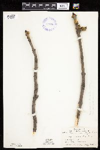 Fraxinus nigra Marshall 373572[1033721]Lakela, Olga 48961942-04-27 United States, Minnesota, Saint Louis, Amity Creek, Duluth;;;;, 46.83889 -92.00667 |
MIN:Plants | 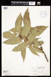 Fraxinus nigra Marshall 373745[1033644]Moore, John; et al. 150661941-08-08 United States, Minnesota, Cass, Cass County...10 mi N of Walker;Chippewa National Forest / Leech Lake Indian Reservation;;;, 47.10284 -94.58694 |
MIN:Plants | 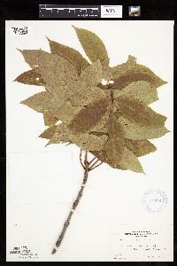 Fraxinus nigra Marshall 373803[1033699]Moore, John; et al. 150781941-08-09 United States, Minnesota, Beltrami, Beltrami County...W shore of Lake Bemidji;;;;, 47.47194 -94.87611 |
MIN:Plants | 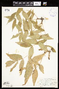 Fraxinus nigra Marshall 396872[1033698]Stevens, O. s.n.1948-09-12 United States, Minnesota, Clay, By old channel, W of N.P. Ry. Sta, Muskoda [historic RR station near Hawley];;139N;45W;18, 46.85442 -96.41411 |
Google Map
Google Maps is a web mapping service provided by Google that features a map that users can pan (by dragging the mouse) and zoom (by using the mouse wheel). Collection points are displayed as colored markers that when clicked on, displays the full information for that collection. When multiple species are queried (separated by semi-colons), different colored markers denote each individual species.