University of Minnesota
http://www.umn.edu/
612-625-5000
http://www.umn.edu/
612-625-5000
Minnesota Biodiversity Atlas
Bell Museum
Dataset: MIN-Plants
Taxa: Matteuccia
Search Criteria: excluding cultivated/captive occurrences
Bell Museum plants | |
 MIN:Plants | 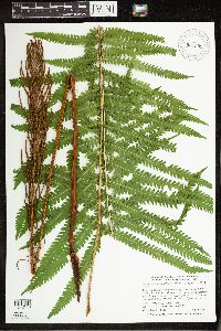 Matteuccia struthiopteris var. pensylvanica (Willdenow) C.V. Morton 907599[1342146]Smith, Welby 286822000-07-11 United States, Minnesota, Aitkin, Aitkin County...Rice Lake National Wildlife Refuge; about 5 miles SW of McGregor...T 47N R 24W SE1/4 of SW1/4 of Sec 23;Rice Lake National Wildlife Refuge;047N;24W;23, 46.5388889 -93.3422222 |
MIN:Plants | 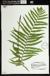 Matteuccia struthiopteris var. pensylvanica (Willdenow) C.V. Morton 914182[1342232]Smith, Welby 226981993-07-01 United States, Minnesota, Otter Tail, Otter Tail County...Maplewood State Park, about 5 mi E-SE of Pelican Rapids...T 135N R 42W SE1/4 of NE1/4 of Sec 9;Maplewood State Park;135N;42W;09, 46.5225 -95.9727778 |
MIN:Plants | 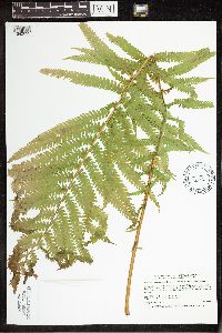 Matteuccia struthiopteris var. pensylvanica (Willdenow) C.V. Morton 463571[1342092]Smith, Welby 167211990-05-29 United States, Minnesota, Dodge, Dodge County ... About 1/2 mile east of Mantorville ... South Branch Middle Fork Zumbro River ... T107N R16W NE1/4 NE1/4 of Sec 21. 107N 16W 21, 44.0630556 -92.7416667 |
MIN:Plants | 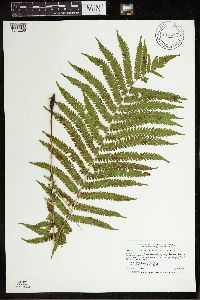 Matteuccia struthiopteris var. pensylvanica (Willdenow) C.V. Morton 913972[1342233]Smith, Welby 252211994-08-19 United States, Minnesota, Pine, Pine County... In Banning State Park, about 3 miles NNW of Sandstone...Kettle River...T43N R20W NW1/4 of SW1/4 of Sec 35;Banning State Park;043N;20W;35, 46.1625 -92.8402778 |
MIN:Plants | 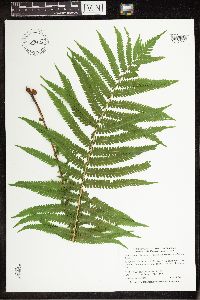 Matteuccia struthiopteris var. pensylvanica (Willdenow) C.V. Morton 897477[1342091]Smith, Welby 292142001-06-27 United States, Minnesota, Lake, Lake County ... Crosby-Manitou State Park, about 3 air miles from Lake Superior ... T58N R6W NW1/4 of SW1/4 of Sec 28;Crosby Manitou State Park / North Shore;058N;06W;28, 47.4772222 -91.105 |
MIN:Plants | 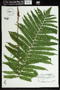 Matteuccia struthiopteris var. pensylvanica (Willdenow) C.V. Morton 909800[1342234]Smith, Welby 245431994-07-02 United States, Minnesota, Scott, Scott County ... In the Minnesota Valley, about 7.5 miles north of Jordan ... T115N R23W SE1/4 of NW1/4 of Sec. 9;;115N;23W;09, 44.77986 -93.58992 |
MIN:Plants | 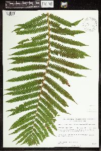 Matteuccia struthiopteris var. pensylvanica (Willdenow) C.V. Morton 431775[1342093;1342094]Gerdes, Lynden 36091999-07-22 United States, Minnesota, Cook, Boundary Waters Canoe Area Wilderness / Superior National Forest. T65N R02E S22SWNWSW Cook County ... Superior National Forest, BWCAW. Forest at base of east-facing cliff feature; approximately 0.5 mile north of the West Pike Lake area.. T065N R02E S22, 48.100223 -90.177463 |
MIN:Plants | 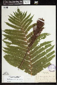 Matteuccia struthiopteris var. pensylvanica (Willdenow) C.V. Morton 295337[1342293]Benner, F.; Benner, J. 1091928-08-03 United States, Wisconsin, Polk, 3 mi N. of St. Croix Falls. River Road;Saint Croix National Riverway;;;, 45.090547 -92.4333 |
MIN:Plants | 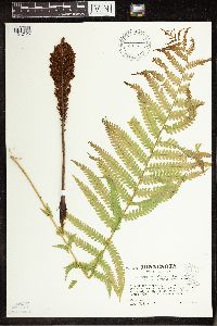 Matteuccia struthiopteris var. pensylvanica (Willdenow) C.V. Morton 508162[1342125]Kaul, Robert B. 67351990-05-24 United States, Minnesota, Steele, Steele Co. ... above Maple Creek ... Mineral Springs;107N;20W, 44.094946 -93.228484 |
MIN:Plants | 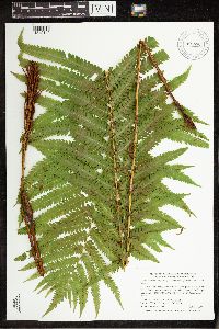 Matteuccia struthiopteris var. pensylvanica (Willdenow) C.V. Morton 907705[1342142]Smith, Welby 287652000-06-21 United States, Minnesota, Pine, Pine County ... St. Croix State Park; where Sand Creek joins the St. Croix River ... T40N R18W SE1/4 of SW1/4 of Sec 19;Saint Croix State Park;040N;18W;19, 45.9322222 -92.64 |
MIN:Plants | 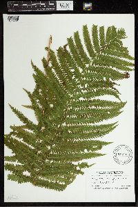 Matteuccia struthiopteris var. pensylvanica (Willdenow) C.V. Morton 915998[1342231]Smith, Welby 251911994-08-18 United States, Minnesota, Beltrami, Lake Bemidji State Park. Beltrami County...On the northeast side of Lake Bemidji, in Lake Bemidji State Park...T147 N R 33W SW1/4 of NE1/4 of Sec 23. 147N 33W 23, 47.5347222 -94.8311111 |
MIN:Plants | 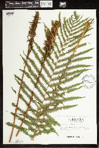 Matteuccia struthiopteris var. pensylvanica (Willdenow) C.V. Morton 507991[1342124]Kaul, R. 25621982-07-31 United States, Minnesota, Clearwater, Clearwater County, 47.577653 -95.379024 |
MIN:Plants | 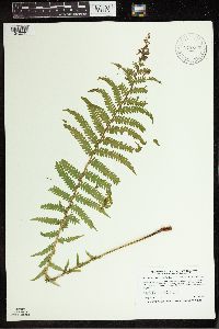 Matteuccia struthiopteris var. pensylvanica (Willdenow) C.V. Morton 912699[1342235]Smith, Welby 241551994-05-30 United States, Minnesota, Itasca, Itasca County...Scenic State Park; about 9 miles south-southeast of Effie...T 60N R 26W NE1/4 of NE1/4 of Sec 1;Scenic State Park;060N;26W;01, 47.7186111 -93.5808333 |
MIN:Plants | 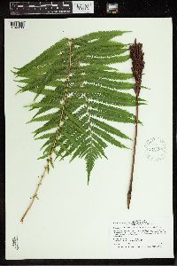 Matteuccia struthiopteris var. pensylvanica (Willdenow) C.V. Morton 910085[1342236]Smith, Welby 246861994-07-13 United States, Minnesota, Polk, Polk County ... About 5 miles southwest of Erskine ... T148N R43W NE1/4 of NW1/4 of Sec 25;;148N;43W;25, 47.6094444 -96.0797222 |
MIN:Plants | 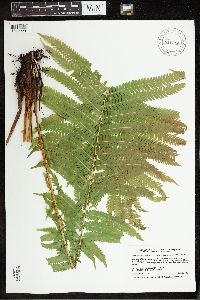 Matteuccia struthiopteris var. pensylvanica (Willdenow) C.V. Morton 916864[1342228]Smith, Welby 223201993-06-03 United States, Minnesota, Sibley, Vale Wildlife Management Area. Sibley County ... Vale State Wildlife Management Area; in the valley of High Island Creek, about 2.5 miles southwest of its confluence with the Minnesota River ... T113N R26W NE1/4 of SW1/4 of Sec 27. 113N 26W 27, 44.5625 -93.9427778 |
MIN:Plants | 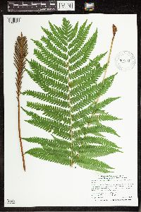 Matteuccia struthiopteris var. pensylvanica (Willdenow) C.V. Morton 908431[1342151]Smith, Welby 311312008-08-18 United States, Minnesota, Beltrami, Beltrami County...About 12 miles north-northeast of Bemidji...T 148 R 33 SW1/4 of NE1/4 of Sec 12;Buena Vista State Forest;148N;33W;12, 47.6522222 -94.8072222 |
MIN:Plants | 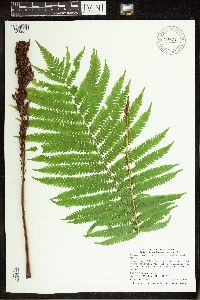 Matteuccia struthiopteris var. pensylvanica (Willdenow) C.V. Morton 907713[1342087]Smith, Welby 308802008-06-12 United States, Minnesota, Benton, Sartell Wildlife Management Area. Benton County ... Sartell State Wildlife Management Area, about 5 miles southeast of Royalton ... T38N R31W NW1/4 of SW1/4 of Sec 15. 038N 31W 15, 45.7838889 -94.1927778 |
MIN:Plants | 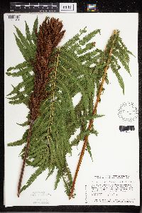 Matteuccia struthiopteris var. pensylvanica (L.) Todaro 439896[1311349]Smith, Welby 129891987-06-16 United States, Minnesota, Washington, Washington Co. On the E side of Highway 4, about 1/2 mi NW of Marine on St. Croix. SW1/4 NE1/4 sec 1, T31N R20W;;031N;20W;1, 45.204481 -92.781863 |
MIN:Plants | 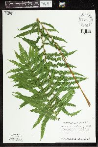 Matteuccia struthiopteris var. pensylvanica (L.) Todaro 440227[1342272]Smith, Welby 128511987-06-04 United States, Minnesota, Mille Lacs, Mille Lacs Co. Mille Lacs State Wildlife Management Area; about 11 mi N of Bock. SE1/4 NE1/4 sec 24, T40N R26W;Mille Lacs Wildlife Management Area;040N;26W;24, 45.9472237 -93.5199966 |
MIN:Plants | 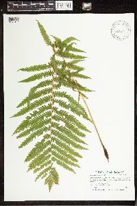 Matteuccia struthiopteris var. pensylvanica (L.) Todaro 445642[1342149]Smith, Welby 191991991-07-08 United States, Minnesota, Koochiching, Franz Jevne State Park. Koochiching Co.; Franz Jevne State Park, in the Rainy River Valley, about 2 miles northeast of Birchdale; T 160N R 27W SW1/4 of SW1/4 of sec 26. 160N 27W 26, 48.6427765 -94.078331 |
MIN:Plants | 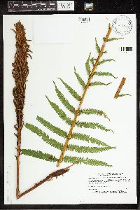 Matteuccia struthiopteris var. pensylvanica (L.) Todaro 459042[1342271]Lee, Michael MDL2371993-07-14 United States, Minnesota, Dakota, Dakota Co.; Lebanon Hills Regional Park, Holland Lake; T27N R19W [Holland Lake is in R23W] NE1/4 of NE1/4 of sEc 34;Lebanon Hills County Park;027N;23W;34, 44.788135 -93.149391 |
MIN:Plants | 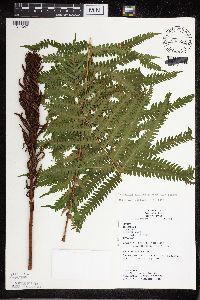 Matteuccia struthiopteris var. pensylvanica (L.) Todaro 833590[1311347]Juhnke, C. 2401991-08-08 United States, Minnesota, Fillmore, Forestville State Park. Fillmore Co. T102N R12W Sec.13 SW NE SW;Forestville State Park;102N;12W;13, 43.637724 -92.219269 |
MIN:Plants | 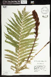 Matteuccia struthiopteris var. pensylvanica (L.) Todaro 835635[1342273]Cholewa, A.; Engels, A. 21691995-06-23 United States, Minnesota, Aitkin, Aitkin Co. Savanna Portage State Park, about 17 mi NE of McGregor, SW end of Wolf Lake, T50N R22W S6 NE1/4;Savanna Portage State Park;050N;22W;6, 46.848872 -93.172213 |
MIN:Plants | 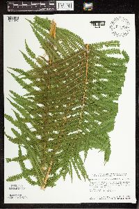 Matteuccia struthiopteris var. pensylvanica (L.) Todaro 841338[1342172]Smith, Welby 133551987-07-07 United States, Minnesota, Washington, Washington Co. Island in the St. Croix River, about 2 mi NE of Scandia; SE1/4 SE1/4 sec.7, T32N R19W;;032W;19W;7, 45.2675018 -92.7555542 |
MIN:Plants |  Matteuccia struthiopteris var. pensylvanica (Willdenow) C.V. Morton 220392[1342275]Rosendahl, C.; Butters, F. 46671924-07-07 United States, Minnesota, Cook, At Kimball Creek near Grand Marais. Cook Co.;North Shore / Superior National Forest;061N;02E;, 47.857542 -90.247186 |
MIN:Plants |  Matteuccia struthiopteris var. pensylvanica (Willdenow) C.V. Morton 275784[1342259]Moyle, J. 1221930-07-01 United States, Minnesota, Clearwater, Itasca Park. Clearwater Co. Garrison Pt. SW NW 15 T143 R36;Itasca State Park;143N;36W;15, 47.202782 -95.222917 |
MIN:Plants |  Matteuccia struthiopteris var. pensylvanica (Willdenow) C.V. Morton 276912[1342200]Huff, N. 951914-07-05 United States, Minnesota, Lake, North Kawishiwi River, Lake Co.;Superior National Forest;N;;, 47.583104 -91.421915 |
MIN:Plants |  Matteuccia struthiopteris var. pensylvanica (Willdenow) C.V. Morton 281428[1342248]Roberts, Thomas s.n.1884-07-13 United States, Minnesota, Ramsey, St. Paul;;;;, 44.960694 -93.076799 |
MIN:Plants | 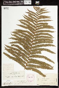 Matteuccia struthiopteris var. pensylvanica (Willdenow) C.V. Morton 281434[1342178]Roberts, Thomas s.n.1884-07-13 United States, Minnesota, Ramsey, St. Paul;;;;, 44.960694 -93.076799 |
MIN:Plants | 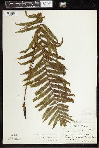 Matteuccia struthiopteris var. pensylvanica (Willdenow) C.V. Morton 281877[1342274]Rosendahl, C. 63341930-08-27 United States, Minnesota, Cook, Grand Portage Harbor;Grand Portage Indian Reservation / North Shore;061N;01E;, 47.959234 -89.821113 |
MIN:Plants | 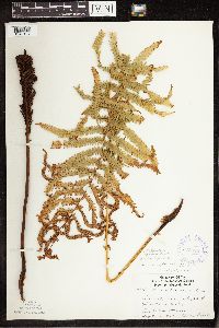 Matteuccia struthiopteris var. pensylvanica (Willdenow) C.V. Morton 345529[1342127]Lakela, Olga 23481937-09-04 United States, Minnesota, Saint Louis, SE slope of Hunter's Hill, Duluth;N, 46.783273 -92.106579 |
MIN:Plants | 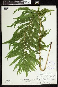 Matteuccia struthiopteris var. pensylvanica (Willdenow) C.V. Morton 347279[1342190]Lakela, Olga 20301937-07-03 United States, Minnesota, Saint Louis, U.S. Gov. Prop, Sec.20;;N;;, 47.59195 -92.438477 |
MIN:Plants | 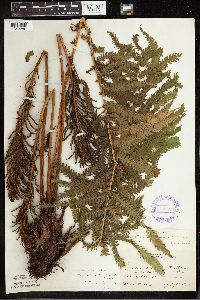 Matteuccia struthiopteris var. pensylvanica (Willdenow) C.V. Morton 352529[1342280]Nielsen, E. 221928-07-22 United States, Minnesota, Beltrami, Shrain's [?] Point, Cass Lake;Chippewa National Forest / Leech Lake Indian Reservation;N;;, 47.37193 -94.610062 |
MIN:Plants | 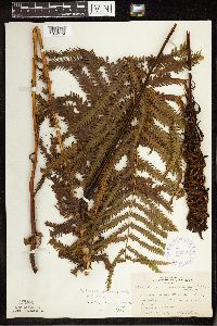 Matteuccia struthiopteris var. pensylvanica (Willdenow) C.V. Morton 353884[1342134]Lakela, Olga 28131938-09-18 United States, Minnesota, Saint Louis, Haines Rd. at Skyline Parkway, 40th Ave. W, Duluth;;N;;, 46.946808 -92.345765 |
MIN:Plants | 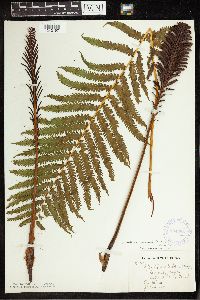 Matteuccia struthiopteris var. pensylvanica (Willdenow) C.V. Morton 354388[1342197]Barrows, Vera F. 781939-07-09 United States, Minnesota, Saint Louis, E end of Echo Trail, Ely;Superior National Forest;N, 48.116014 -92.14764 |
MIN:Plants | 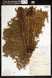 Matteuccia struthiopteris var. pensylvanica (Willdenow) C.V. Morton 358782[1342180]Anonymous 911912-09-10 United States, Minnesota, Saint Louis, Meadowlands;;N;;, 47.071884 -92.732416 |
MIN:Plants | 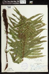 Matteuccia struthiopteris var. pensylvanica (Willdenow) C.V. Morton 362877[1342191]Butters, F.K. 135841940-09-18 United States, Minnesota, Chisago, 3 mi N of Taylors Falls, Chisago Co.;;N;;, 45.445347 -92.652429 |
MIN:Plants | 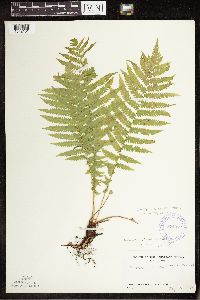 Matteuccia struthiopteris var. pensylvanica (Willdenow) C.V. Morton 374082[1342131]Linnaean Club, U of M, 301939-05-21 United States, Minnesota, Rice, Nerstrand Woods, Rice Co.;Nerstrand Woods State Park;110N;19W;, 44.344855 -93.11056 |
MIN:Plants | 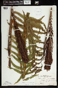 Matteuccia struthiopteris var. pensylvanica (Willdenow) C.V. Morton 381138[1342244]Moore, John; Moore, Marjorie 152691942-06-11 United States, Minnesota, Isanti, NW1/4, Sec.32, Stanchfield Twp, Isanti Co.;;037N;23W;32, 45.654722 -93.23796 |
MIN:Plants | 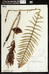 Matteuccia struthiopteris var. pensylvanica (Willdenow) C.V. Morton 387474[1342209]Schuster, R.M. s.n.1947-07-00 United States, Minnesota, Lake, Lake Co. Gooseberry Falls State Park;Gooseberry Falls State Park / North Shore;054N;09W;00, 47.669689 -91.416748 |
MIN:Plants | 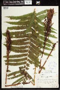 Matteuccia struthiopteris var. pensylvanica (Willdenow) C.V. Morton 387475[1342279]Burns, G.; Hendrickson, M. 1891938-07-19 United States, Minnesota, Cook, Cook Co. Cliff 1/2 mi SW of W end of West Pike Lake, T65N R2E;Boundary Waters Canoe Area Wilderness / Superior National Forest;065N;02E;, 48.10737 -90.224172 |
MIN:Plants | 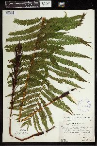 Matteuccia struthiopteris var. pensylvanica (Willdenow) C.V. Morton 387476[1342245]Butters, F.; et al. 1491938-07-13 United States, Minnesota, Cook, Between Mountain and Pike Lakes.;Boundary Waters Canoe Area Wilderness / Superior National Forest;065N;02E;, 47.765692 -90.591554 |
MIN:Plants | 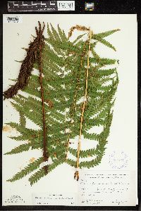 Matteuccia struthiopteris var. pensylvanica (Willdenow) C.V. Morton 387477[1342213]Moore, John W. 192021946-08-31 United States, Minnesota, Morrison, Morrison Co. 1 mi S of "Snow" School-house, Parker Twp.;;130N;31W;00, 46.007122 -94.278687 |
MIN:Plants | 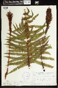 Matteuccia struthiopteris var. pensylvanica (Willdenow) C.V. Morton 387478[1342211]Moore, John W. 180951945-08-02 United States, Minnesota, Pine, Pine Co. St. Croix River, 1/2 mi S of Danbury Rd.;Saint Croix State Park;041N;16W;26, 46.120767 -92.74127 |
MIN:Plants | 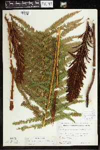 Matteuccia struthiopteris var. pensylvanica (Willdenow) C.V. Morton 387479[1342198]Moore, John W. 179991945-07-25 United States, Minnesota, Morrison, Morrison Co. Railroad tracks near Little Hillman Creek at Central Valley;;N;;, 46.007122 -94.278687 |
MIN:Plants | 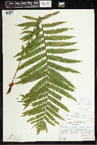 Matteuccia struthiopteris var. pensylvanica (Willdenow) C.V. Morton 387480[1342276]Butters, F.; Abbe, E. 1951936-06-30 United States, Minnesota, Cook, Cook Co. About 2 mi W of hwy. from the border to Mineral Center, T63N R5E;Grand Portage Indian Reservation / North Shore;063N;05E;, 47.966692 -89.809933 |
MIN:Plants | 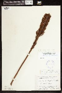 Matteuccia struthiopteris var. pensylvanica (Willdenow) C.V. Morton 387481[1342132]Holzinger, John s.n.1905-10-01 United States, Minnesota, Winona, Winona Co. La Moille Cave;;106N;05W;, 44.197 -91.941562 |
MIN:Plants | 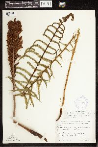 Matteuccia struthiopteris var. pensylvanica (Willdenow) C.V. Morton 387482[1342098]Moore, John 171331945-06-09 United States, Minnesota, Morrison, Morrison Co. 1 mi S of Motley;;N;;, 46.007122 -94.278687 |
MIN:Plants | 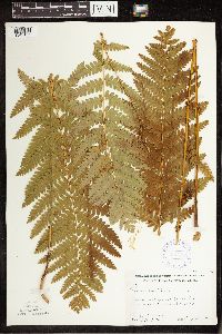 Matteuccia struthiopteris var. pensylvanica (Willdenow) C.V. Morton 387726[1342165]Moore, John W. 167921946-08-03 United States, Minnesota, Itasca, Itasca Co. Beside Hwy.2, 1 mi W of Grand Rapids;;N;;, 47.237164 -93.551534 |
MIN:Plants | 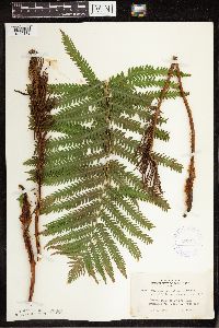 Matteuccia struthiopteris var. pensylvanica (Willdenow) C.V. Morton 407661[1342179]Lakela, Olga 90561949-07-20 United States, Minnesota, Saint Louis, Prairie Lake, SW St. Louis Co.;;050N;20W;, 46.7833 -92.9 |
MIN:Plants | 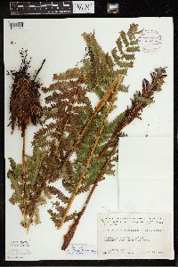 Matteuccia struthiopteris var. pensylvanica (Willdenow) C.V. Morton 411986[1342250]Moore, John; Moore, Marjorie 111961939-07-27 United States, Minnesota, Lake of the Woods, Lake of the Woods Co. W side of Harrison River, Northwest Angle;Northwest Angle;N;;, 49.059039 -94.920086 |
MIN:Plants | 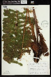 Matteuccia struthiopteris var. pensylvanica (Willdenow) C.V. Morton 437103[1342253]Moore, John; Moore, Marjorie 122141939-08-29 United States, Minnesota, Lake of the Woods, Lake of the Woods Co. W shore of Four Mile Bay, Lake of the Woods;;162N;32W;, 49.059039 -94.920086 |
MIN:Plants |  Matteuccia struthiopteris var. pensylvanica (Willdenow) C.V. Morton 442292[1342196]Lakela, Olga 136891951-09-02 United States, Minnesota, Saint Louis, Pike Lake #53, N of Duluth;;N;;, 46.85 -92.3 |
MIN:Plants |  Matteuccia struthiopteris var. pensylvanica (Willdenow) C.V. Morton 442707[1342189]Lakela, Olga 130061951-07-10 United States, Minnesota, Saint Louis, Namakan Lake, Kettle Falls, St. Louis Co.;Voyageurs National Park;070N;18W;, 48.49944 -92.63889 |
MIN:Plants |  Matteuccia struthiopteris var. pensylvanica (Willdenow) C.V. Morton 443000[1342136]Lakela, Olga 13318a1951-07-17 United States, Minnesota, Saint Louis, Ash River about 2 mi downstream from the Frontier Lodge. St. Louis Co.;Kabetogama State Forest;068N;19W;00, 48.1667 -92.6833 |
MIN:Plants |  Matteuccia struthiopteris var. pensylvanica (Willdenow) C.V. Morton 446161[1342170]Moore, John W. 173321945-06-20 United States, Minnesota, Red Lake, Red Lake County...1 mi E of Red Lake Falls;;151N;44W;, 47.88219 -96.272056 |
MIN:Plants | 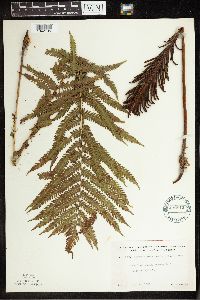 Matteuccia struthiopteris var. pensylvanica (Willdenow) C.V. Morton 492812[1342195]Lakela, Olga 169031953-08-25 United States, Minnesota, Saint Louis, St. Louis Co. Swan River woods, hwy.#5, N of Toivola;;N;;, 47.1667 -92.8667 |
MIN:Plants | 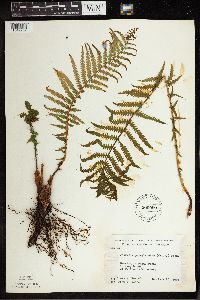 Matteuccia struthiopteris var. pensylvanica (Willdenow) C.V. Morton 500059[1342252]Rustad, Orwin 121946-06-10 United States, Minnesota, Rice, Rice Co. At Faribault;;N;;, 44.294964 -93.268827 |
MIN:Plants | 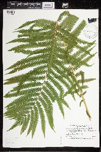 Matteuccia struthiopteris var. pensylvanica (Willdenow) C.V. Morton 514773[1311343]Smith, Welby 189651991-06-25 United States, Minnesota, Todd, Grey Eagle Wildlife Management Area. Todd Co.; Grey Eagle State Wildlife Management Area, about 3 mi W of Grey Eagle; T127N R33W SW1/4 of SE1/4 of Sec 10 Todd Co.; Grey Eagle State Wildlife Management Area, about 3 mi W of Grey Eagle;T127N R33W SW1/4 of SE1/4 of Sec 10. 127N 33W 10, 45.8191681 -94.815834 |
MIN:Plants | 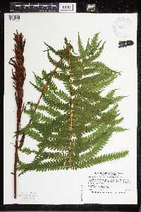 Matteuccia struthiopteris var. pensylvanica (Willdenow) C.V. Morton 519972[1311351]Smith, Welby 193861991-07-10 United States, Minnesota, Koochiching, Grand Mound Historical Site. Koochiching County...Grand Mound Historic Site, about 18 miles W of International Falls; floodplain of the Rainy River...T70N R26W NW1/4 of NE1/4 of Sec 32. 070N 26W 32, 48.5158333 -93.7083333 |
MIN:Plants | 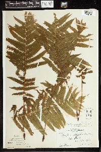 Matteuccia struthiopteris var. pensylvanica (Willdenow) C.V. Morton 52655[1342186]Skinner, S. 2471902-06-28 United States, Minnesota, Murray, Lake Shetek, Heron Lake region;Lake Shetek State Park;N;;, 44.124433 -95.693123 |
MIN:Plants | 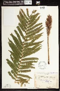 Matteuccia struthiopteris var. pensylvanica (Willdenow) C.V. Morton 53112[1342174]Sheldon, Edmund S8101891-07-00 United States, Minnesota, Brown, Siegel Twp, Brown Co.;;109N;31W;, 44.240385 -94.550839 |
MIN:Plants | 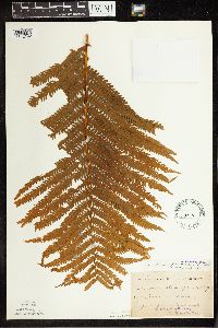 Matteuccia struthiopteris var. pensylvanica (Willdenow) C.V. Morton 53159[1342192]Taylor, B. T2591891-06-00 United States, Minnesota, Waseca, Janesville;;N;;, 44.116078 -93.708004 |
MIN:Plants | 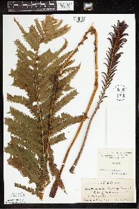 Matteuccia struthiopteris var. pensylvanica (Willdenow) C.V. Morton 53880[1342269]MacMillan, C.; et al. 21621894-07-26 United States, Minnesota, Lake of the Woods, Lake of the Woods. Island No.4;;;;, 49.059039 -94.920086 |
MIN:Plants | 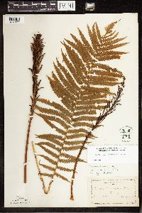 Matteuccia struthiopteris var. pensylvanica (Willdenow) C.V. Morton 53882[1342133]Manning, Sara s.n.1883-06-30 United States, Minnesota, Wabasha, Lake City;N, 44.449412 -92.266844 |
MIN:Plants | 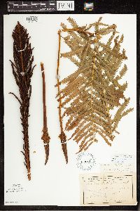 Matteuccia struthiopteris var. pensylvanica (Willdenow) C.V. Morton 53884[1342175]Anderson, A. A6541893-07-00 United States, Minnesota, Cass, Gull Lake, Cass Co.;N, 46.446379 -94.35099 |
MIN:Plants | 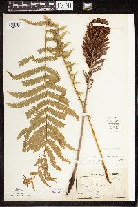 Matteuccia struthiopteris var. pensylvanica (Willdenow) C.V. Morton 53885[1342153]Sheldon, Edmund S21911892-06-00 United States, Minnesota, Mille Lacs, Mille Lacs Lake;;N;;, 45.938041 -93.630083 |
MIN:Plants | 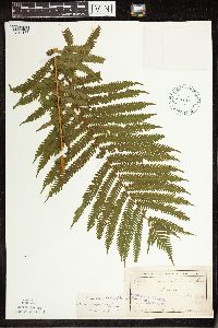 Matteuccia struthiopteris var. pensylvanica (Willdenow) C.V. Morton 53889[1342137]Sheldon, Edmund S28511892-07-00 United States, Minnesota, Kanabec, Mora, Kanabec Co.;039N;24W, 45.805189 -93.190895 |
MIN:Plants | 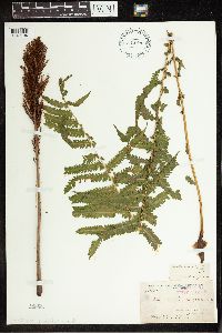 Matteuccia struthiopteris var. pensylvanica (Willdenow) C.V. Morton 53890[1342194]Arthur, J.C. 165A1886-07-24 United States, Minnesota, Saint Louis, Vermilion Lake;;;;, 47.89167 -92.36667 |
MIN:Plants | 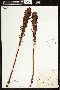 Matteuccia struthiopteris var. pensylvanica (Willdenow) C.V. Morton 53891[1342162]Oestlund, O. s.n.1886-08-00 United States, Minnesota, Hennepin, Minneapolis;;N;;, 44.979965 -93.263836 |
MIN:Plants | 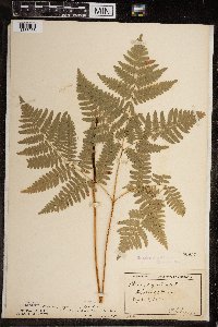 Matteuccia struthiopteris var. pensylvanica (Willdenow) C.V. Morton 53957[1383068]Lyon, H. 5021899-09-02 United States, Minnesota, Dakota, Hastings;;115N;17W;, 44.743301 -92.852427 |
MIN:Plants | 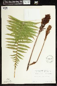 Matteuccia struthiopteris var. pensylvanica (Willdenow) C.V. Morton 552520[1342210]Partch, M. s.n.1958-08-10 United States, Minnesota, Mahnomen, Mahnomen Co. Oakland Twp, Balsam Beach;White Earth Indian Reservation;143N;40W;, 47.321111 -95.966111 |
MIN:Plants | 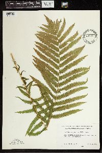 Matteuccia struthiopteris var. pensylvanica (Willdenow) C.V. Morton 553657[1342243]Mielke, Walter 1961958-06-23 United States, Minnesota, Itasca, Itasca Co. Across the road from the Trout Lake Concentrator;;N;;, 47.259755 -93.404884 |
MIN:Plants | 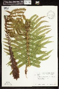 Matteuccia struthiopteris var. pensylvanica (Willdenow) C.V. Morton 558571[1342163]Moore, John 237461958-05-27 United States, Minnesota, Blue Earth, Blue Earth Co. River at Garden City;;N;;, 44.047186 -94.164958 |
MIN:Plants | 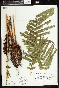 Matteuccia struthiopteris var. pensylvanica (Willdenow) C.V. Morton 565230[1342264]Cotter, Shirley 3081948-07-27 United States, Minnesota, Clearwater, Along road to gravel pit from University of Minnesota Biological Station, Itasca Park, Clearwater Co.;Itasca State Park;143N;36W;, 47.197458 -95.201964 |
MIN:Plants | 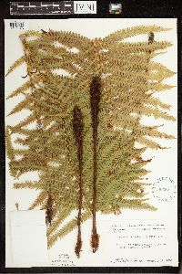 Matteuccia struthiopteris var. pensylvanica (Willdenow) C.V. Morton 566357[1342173]Moore, John W. 242761958-09-18 United States, Minnesota, Blue Earth, Blue Earth Co. 5 mi N of Mankato;;N;;, 44.235994 -93.9994 |
MIN:Plants | 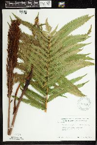 Matteuccia struthiopteris var. pensylvanica (Willdenow) C.V. Morton 568684[1342188]Moore, John 250621960-06-20 United States, Minnesota, Kittson, Kittson Co. Along the river 10 mi E of Hallock;;N;;, 48.774218 -96.726855 |
MIN:Plants | 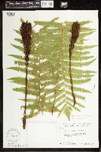 Matteuccia struthiopteris var. pensylvanica (Willdenow) C.V. Morton 574507[1342128]Moore, John W. 248331959-09-18 United States, Minnesota, Kittson, Kittson County...along the river below the dam SE of Lake Bronson;Lake Bronson State Park;161N;46W;, 48.7247 -96.603374 |
MIN:Plants | 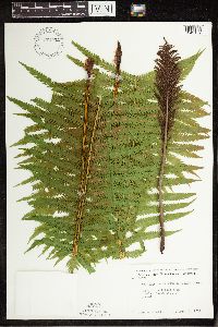 Matteuccia struthiopteris var. pensylvanica (Willdenow) C.V. Morton 574552[1342152]Moore, John 245581959-06-03 United States, Minnesota, Blue Earth, Blue Earth Co. 5 mi SE of Mankato;N, 44.112349 -93.928017 |
MIN:Plants | 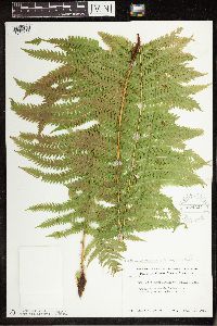 Matteuccia struthiopteris var. pensylvanica (Willdenow) C.V. Morton 574624[1342129]Moore, John W. 247201959-07-29 United States, Minnesota, Kittson, Kittson Co. Below the dam at Bronson State Park;Lake Bronson State Park;161N;46W;, 48.7247 -96.603374 |
MIN:Plants | 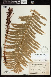 Matteuccia struthiopteris var. pensylvanica (Willdenow) C.V. Morton 59408[1342249]Lyon, H. 2081899-07-10 United States, Minnesota, Houston, Mayville, Houston Co.;;102N;05W;, 43.631001 -91.43252 |
MIN:Plants | 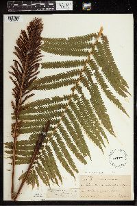 Matteuccia struthiopteris var. pensylvanica (Willdenow) C.V. Morton 59832[1342255]Taylor, B. T9111891-07-00 United States, Minnesota, Pope, Glenwood;;N;;, 45.650239 -95.389758 |
MIN:Plants | 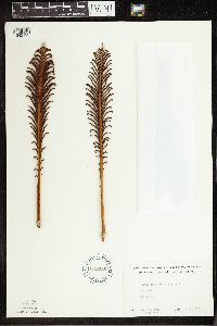 Matteuccia struthiopteris var. pensylvanica (Willdenow) C.V. Morton 602256[1342193]Westkaemper, Remberta s.n.1965-09-00 United States, Minnesota, Stearns, Stearns Co. CSB [College of St. Benedict] woods, St. Joseph;;124n;29W;, 45.55 -94.3167 |
MIN:Plants | 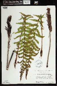 Matteuccia struthiopteris var. pensylvanica (Willdenow) C.V. Morton 616608[1342254]Moore, John; Moore, Marjorie 411969-05-23 United States, Minnesota, Crow Wing, Crow Wing Natural History Area. Crow Wing Co. Creek, E of Chandler Lake, SW1/4, Sec.22, Garrison Twp.;Crow Wing Natural Area;044N;28W;22, 46.278961 -93.86289 |
MIN:Plants | 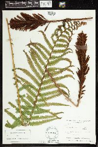 Matteuccia struthiopteris var. pensylvanica (Willdenow) C.V. Morton 631561[1342187]Richards, Donald 16081971-06-04 United States, Minnesota, Itasca, Itasca County...Near shore of lake; Deer Lake, 18 mi NW of Grand Rapids, 47.37852 -93.66181 |
MIN:Plants | 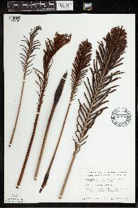 Matteuccia struthiopteris var. pensylvanica (Willdenow) C.V. Morton 669884[1342246]Grimm, Eric 451974-07-20 United States, Minnesota, Hennepin, Hennepin County...YMCA Camp Ihduhapi, Loretto. Hidden Lake;;118N;24W;12, 45.053772 -93.636014 |
MIN:Plants | 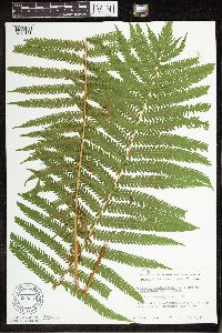 Matteuccia struthiopteris var. pensylvanica (Willdenow) C.V. Morton 669941[1342161]Grimm, Eric 431974-07-20 United States, Minnesota, Hennepin, Hennepin County...YMCA Camp Ihduhapi, Loretto; Hidden Lake;;118N;24W;12, 45.053772 -93.636014 |
MIN:Plants | 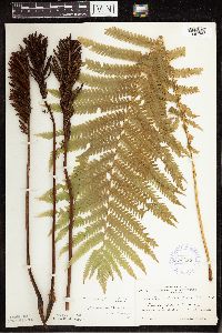 Matteuccia struthiopteris var. pensylvanica (Willdenow) C.V. Morton 674255[1342177]Zeck, Otto 1061933-09-17 United States, Minnesota, Becker, Sec.36, Detroit Twp, Detroit Lakes, Becker Co.;;139N;41W;36, 46.725367 -95.80321 |
MIN:Plants | 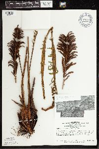 Matteuccia struthiopteris var. pensylvanica (Willdenow) C.V. Morton 681373[1342277]Swanson, Steven 25011976-04-00 United States, Minnesota, Houston, Mississippi River (Navigation Pool #8). Houston Co, site 42;Upper Mississippi National Wildlife Refuge;N;;, 43.575557 -91.264979 |
MIN:Plants | 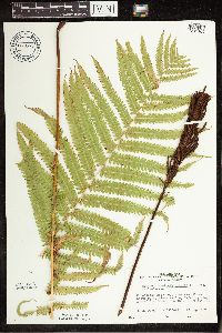 Matteuccia struthiopteris var. pensylvanica (Willdenow) C.V. Morton 681655[1342169]Peck, J.H. 770910131977-09-10 United States, Minnesota, Rice, Rice Co, Nerstrand Woods State Park; T-110N, R-19W sec.9;Nerstrand Woods State Park;110N;19W;9, 44.344855 -93.11056 |
MIN:Plants | 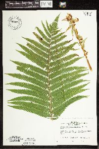 Matteuccia struthiopteris var. pensylvanica (Willdenow) C.V. Morton 681677[1342130]Peck, J.H. 770910311977-09-10 United States, Minnesota, Winona, Winona Co. Whitewater State Park;Whitewater State Park;107N;10W;, 44.058297 -92.058773 |
MIN:Plants | 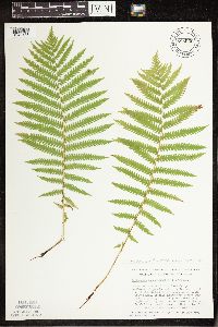 Matteuccia struthiopteris var. pensylvanica (Willdenow) C.V. Morton 685050[1342138]Stassen, Carol 1031977-06-16 United States, Minnesota, Lyon, Camden State Park. Lyon Co. Camden State Park; T110N R42W Sec.5. NE slope adjacent to spring near trail (Chief Whitelodge) which begins at Lyon Co. Camden State Park; T110N R42W Sec.5. NE slope adjacent to spring near trail (Chief Whitelodge) which begins at the South Picnic area.. 110N 42W 5, 44.360726 -95.924697 |
MIN:Plants | 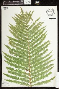 Matteuccia struthiopteris var. pensylvanica (Willdenow) C.V. Morton 685157[1342121;1342122;1342123]Stassen, Carol 2261977-07-30 United States, Minnesota, Lyon, Camden State Park. Lyon County ... Camden State Park; T110N R42W Sec.5 SW1/4. Along Chief Whitelodge Trail (which begins at the South Picnic Ground).. 110N 42W 5, 44.359254 -95.931993 |
MIN:Plants | 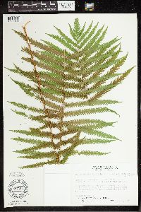 Matteuccia struthiopteris var. pensylvanica (Willdenow) C.V. Morton 687211[1342270]Wheeler, Gerald; Glaser, Paul 16391977-06-06 United States, Minnesota, Itasca, Itasca Co. Coll. Site 35. SE1/4 SW1/4 Sec.13 T53N R26W; approx. 11 mi S-SW of Grand Rapids; between Hwy.169 and the NW s Itasca Co. Coll. Site 35. SE1/4 SW1/4 Sec.13 T53N R26W; approx. 11 mi S-SW of Grand Rapids; between Hwy.169 and the NW shore of Hennessey Lake. 053N 26W 13, 47.074211 -93.58569 |
MIN:Plants | 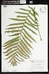 Matteuccia struthiopteris var. pensylvanica (Willdenow) C.V. Morton 692727[1342278]Smith, Welby 6051978-05-24 United States, Minnesota, Wright, Wright Co. T122N R25W N1/2 sec.32. On bank of Mississippi River, about 3 mi NW of Monticello on state hwy.75;;122N;25W;32, 45.331908 -93.860001 |
MIN:Plants | 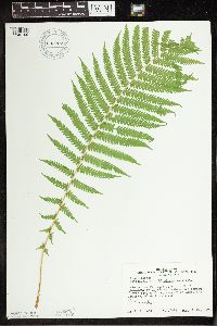 Matteuccia struthiopteris var. pensylvanica (Willdenow) C.V. Morton 692767[1342199]Peck, J. 78-251978-05-31 United States, Minnesota, Fillmore, Fillmore Co.: 2 mi E of Lanesboro on US 16; along Root River;Dorer Memorial Hardwood State Forest;N;;, 43.731685 -91.92365 |
MIN:Plants | 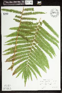 Matteuccia struthiopteris var. pensylvanica (Willdenow) C.V. Morton 694800[1342159]Wagner, W. 731661973-08-09 United States, Minnesota, Clearwater, Clearwater Co.: 0.9 mi S intersect. Rt.9 & 5, Sec.7, R37W, T149N;;149N;37W;7, 47.738932 -95.441475 |
MIN:Plants | 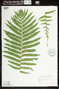 Matteuccia struthiopteris var. pensylvanica (Willdenow) C.V. Morton 694810[1342167]Peck, J.H. 75415P1975-08-03 United States, Minnesota, Lake of the Woods, Lake of the Woods Co.: 4 mi W of Williams on Minn. 11, 49.059039 -94.920086 |
MIN:Plants | 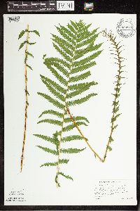 Matteuccia struthiopteris var. pensylvanica (Willdenow) C.V. Morton 694811[1342171]Wagner, W. 753431975-07-26 United States, Minnesota, Lake of the Woods, Lake of the Woods Co.: Rt.72, 2 mi N of Beltrami Co. line, R30W, T157N;;157N;30W;, 49.059039 -94.920086 |
MIN:Plants | 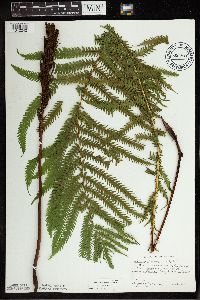 Matteuccia struthiopteris var. pensylvanica (Willdenow) C.V. Morton 694815[1342242]Wagner, W.; et al. 11973-08-10 United States, Minnesota, Polk, Polk Co.: T147N, R44W, Sec.28;;147N;44W;28, 47.521445 -96.270058 |
Google Map
Google Maps is a web mapping service provided by Google that features a map that users can pan (by dragging the mouse) and zoom (by using the mouse wheel). Collection points are displayed as colored markers that when clicked on, displays the full information for that collection. When multiple species are queried (separated by semi-colons), different colored markers denote each individual species.