University of Minnesota
http://www.umn.edu/
612-625-5000
http://www.umn.edu/
612-625-5000
Minnesota Biodiversity Atlas
Bell Museum
Dataset: MIN-Plants
Taxa: Trifolium
Search Criteria: excluding cultivated/captive occurrences
Bell Museum plants | |
 MIN:Plants |  920682[1079427]Smith, Welby 93571984-06-27 United States, Minnesota, Jackson, Kilen Woods State Park. Jackson County...Kilen Woods State Park, about 8 miles north-northwest of Jackson...Des Moines River Valley. SW1/4 NE1/4 section 17, T 103N R 35W. 103N 35W 17, 43.7248138 -95.0646485 |
MIN:Plants |  491631[1079265]Bosch, T. 432001-06-17 United States, Minnesota, Big Stone, Big Stone County ... T120N R45W sec.1-2 ... Approx. 0.5 mile east of Hwy.75 and 2 miles south of Hwy.7.;;120N;45W;01, 45.2325 -96.23654 |
MIN:Plants |  913174[1078998]Scott, P. 26292006-07-25 United States, Minnesota, Lake, Lake County ... Near Nickel Lake, SNF. T62N R10W sec.29 SESWNW.;Superior National Forest;062N;10W;29, 47.8266734 -91.6289786 |
MIN:Plants |  912958[1079479]Smith, Welby 243801994-06-14 United States, Minnesota, Yellow Medicine, Upper Sioux Agency State Park. Yellow Medicine County...Upper Sioux Agency State Park; In the Minnesota Valley about seven miles southwest of Sacred Heart...T 115N R 38W SE1/4 of SE1/4 of Sec 29. 115N 38W 29, 44.735 -95.4425 |
MIN:Plants |  493120[1079121]Juhnke, C. 304 CMJ FRO1999-06-02 United States, Minnesota, Goodhue, Frontenac State Park Goodhue County ... Along trail heading SW to walk-in campsites ... T112N R 13W SW SW NE 2;Frontenac State Park;112N;13W;02, 44.5350723 -92.3391578 |
MIN:Plants |  480665[1079234]Hammer, W. s.n.2002-07-08 United States, Minnesota, Ramsey, Ramsey County, Arden Hills. Twin Cities Army Ammunition Plant-Arden Hills Army Training Site. Grass management unit 19. East side of NE 1/4, NW 1/4, section 15, T.30 N, R.23W ... from North of split in restoration.. 030N 23W 15, 45.0864512 -93.1575501 |
MIN:Plants |  489146[1079174]Smith, Welby 157491989-07-17 United States, Minnesota, Benton, Benlacs Wildlife Management Area. Benton County ... Benlacs State Wildlife Management Area, about 7 miles SE of Foley ... SE1/4 SE1/4 section 12, T36N R 28W. 036N 28W 12, 45.6258528 -93.7706844 |
MIN:Plants |  915869[1079271]Smith, Welby 224811993-06-18 United States, Minnesota, Grant, Grant County...On the south side of Ask Lake, about 1.5 miles east-southest of Ashby...T 130N R 41W NW1/4 of SW1/4 of Sec 12. 130N 41W 12, 46.0847222 -95.7886111 |
MIN:Plants |  431975[1079266]Cully, Anne; et al. s.n.1997-08-10 United States, Minnesota, Houston, Houston County, Mound Prairie Scientific and Natural Area T103N, R5W, nw!/4 [sic] Section 3;Mound Prairie Scientific Natural Area;103N;05W;03, 43.7533038 -91.4225152 |
MIN:Plants |  Trifolium bolanderi A. Gray 236992[1079025]Congdon, J. s.n.1885-06-30 United States, California, Mariposa, Peregoy's south of Yosemite, Mariposa County;Yosemite National Park |
MIN:Plants |  913531[1079270]Smith, Welby 227341993-07-02 United States, Minnesota, Becker, Dunton County Park. Becker County... In Dunton County Park, about 3 miles southwest of Detroit Lakes...Muskrat Lake...T138N R41W SE1/4 of NE1/4 of Sec 8. 138N 41W 8, 46.7825 -95.8816667 |
MIN:Plants |  453919[1078968]Smith, Welby 156701989-07-11 United States, Minnesota, Kanabec, Mille Lacs Wildlife Management Area. Kanabek County ... Mille Lacs State Wildlife Management Area, about 9 miles northwest of Mora ...SW1/4 SW1/4 section 16, T40N R25W. 040N 25W 16, 45.9511111 -93.4711111 |
MIN:Plants |  918237[1079272]Smith, Welby 223631993-06-08 United States, Minnesota, Carver, Carver County...Carver Park Reserve; about 5 miles west of Chanhassen...T 116N R 24W SE1/4 of NE1/4 of Sec 11;Carver Park Reserve County Park;116N;24W;11, 44.8716667 -93.6644444 |
MIN:Plants |  Trifolium breweri S. Watson 236910[1079027]Congdon, J. s.n.1885-06-30 United States, California, Mariposa, Glacier Pint Turnpike, Mariposa County;Yosemite National Park;;;, 37.82714 -119.53674 |
MIN:Plants |  509332[1079257]Roitsch, C. 5162000-08-01 United States, Minnesota, Morrison, [no further data];Crane Meadows National Wildlife Refuge;;;, 45.9667 -94.3667 |
MIN:Plants |  898396[1078969]Lee, Michael MDL40712005-08-10 United States, Minnesota, Becker, Two Inlets State Forest. Becker County...moraine west of Hungry Man Lakes, two miles north of Two Inlets...along logging road...T141N R36W NW1/4 of NW1/4 Sec. 2. 141N 36W 2, 47.06285 -95.209194 |
MIN:Plants |  920684[1079344]Smith, Welby 94101984-06-27 United States, Minnesota, Jackson, Sioux Valley Wildlife Management Area. Jackson County...Sioux Valley State Wildlife Management Area, about one mile south-southeast of Sioux Valley (town). NE1/4 NE1/4 section 29, T 101N R 37W. 101N 37W 29, 43.522292 -95.3046432 |
MIN:Plants |  Trifolium breweri S. Watson 236797[1079028]Congdon, J. s.n.1896-07-09 United States, California, Tuolumne, Tioga Road, Tuolumne Co.;Yosemite National Park |
MIN:Plants |  477148[1079382]Hammer, W. s.n.2002-07-12 United States, Minnesota, Ramsey, Ramsey County, Arden Hills. Twin Cities Army Ammunition Plant-Arden Hills Army Training Site. Grass management unit 32. Central part of N 1/2, NE 1/4, section 16, T.30 N, R.23W. 030N 23W 16, 45.0863818 -93.1779838 |
MIN:Plants |  478916[1078961]Swanson, Scott 21222001-08-09 United States, Minnesota, Sherburne, Sherburne National Wildlife Refuge;Sherburne National Wildlife Refuge;;;, 45.515 -93.71028 |
MIN:Plants |  Trifolium breweri S. Watson 236922[1079026]Congdon, J. s.n.1891-07-21 United States, California, Mariposa, Big Tree Grove, Mariposa County;Yosemite National Park;;;, 37.51 -119.60111 |
MIN:Plants |  493696[1078965]Juhnke, C. 051 CMJ FRO1998-08-27 United States, Minnesota, Goodhue, Frontenac State Park. Goodhue County ... main park road ... T 112N R 13W NW NW SW 2;Frontenac State Park;112N;13W;02, 44.49871 -92.36985 |
MIN:Plants |  914570[1079390]Smith, Welby 225121993-06-18 United States, Minnesota, Douglas, Douglas County...Lake Carlos State Park, about 6 miles north of Alexandria... T129N R 37W SE1/4 of SW 1/4 of Sec 9;Lake Carlos State Park;129N;37W;09, 45.9958333 -95.3469444 |
MIN:Plants |  Trifolium microcephalum Pursh 794908[1079200]Schaaf, J. 1891982-08-16 United States, Nevada, Humboldt, Pine Canyon, Santa Rosa Mts.;;;;, 41.498286 -117.774892, 1585m |
MIN:Plants |  911139[1079269]Smith, Welby 218581992-09-03 United States, Minnesota, Watonwan, Watonwan County...At the public access on the north side of Fedji Lake, about 2 miles northeast of Madelia...T 107N R 30W SW1/4 of SW1/4 of Sec 12. 107N 30W 12, 44.0816667 -94.3880556 |
MIN:Plants |  435618[1079320]Nation, R. 94-0771994-06-08 United States, Minnesota, Mower, Lake Louise State Park. Mower Co.; Tract #3A. T101N R14W NW1/4 of SW1/4 of Sec. 21;Lake Louise State Park;101N;14W;21, 43.53658 -92.51904 |
MIN:Plants |  435200[1079149]Nation, R. 94-1171994-06-21 United States, Minnesota, Mower, Lake Louise State Park. Mower Co.; Tract #13N. T101N R14W NE1/4 of SE1/4 of Sec. 21;Lake Louise State Park;101N;14W;21, 43.53658 -92.51904 |
MIN:Plants |  432074[1078950]DeMink, L. 3661999-08-19 United States, Minnesota, Morrison, Crane Meadows National Wildlife Refuge; NWNE 30-T40N-R31W;Crane Meadows National Wildlife Refuge;040N;31W;30, 45.9338958 -94.2515644 |
MIN:Plants | 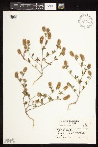 453875[1078962]Kaul, R. 71481992-08-06 United States, Minnesota, Saint Louis, St. Louis Co.; on US 53 near Eveleth.;;058N;18W;, 47.466258 -92.524285 |
MIN:Plants | 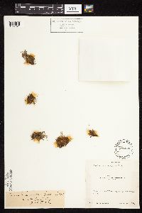 Trifolium variegatum Nuttall 236085[1079524]Congdon, J. s.n.1883-06-05 United States, California, Mariposa, Turnpike out of Yosemite, Mariposa County;Yosemite National Park |
MIN:Plants | 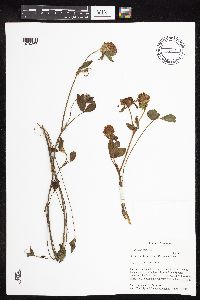 438203[1079267]Paulin, Amy; et al. s.n.1998-06-23 United States, Minnesota, Rock, Rock County, Bluemound [sic] State Park UTM 0725126N 4841790E;Blue Mounds State Park;103N;45W;24, 43.7105053 -96.1827905 |
MIN:Plants | 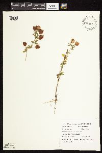 Trifolium campestre Schreber 508845[1079049]Roitsch, C. 4742000-07-31 United States, Minnesota, Morrison, Crane Meadows NWR;Crane Meadows National Wildlife Refuge;;;, 45.934941 -94.248903 |
MIN:Plants | 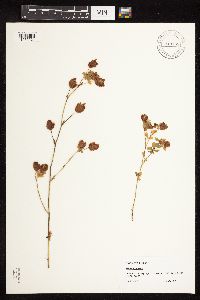 Trifolium aureum Pollich 913168[1079024]Scott, P. 26282006-07-25 United States, Minnesota, Lake, Lake County ... Near Nickel Lake, SNF. T62N R10W sec.29 NWSW.;Superior National Forest;062N;10W;29, 47.8266734 -91.6289786 |
MIN:Plants | 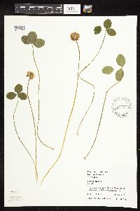 484258[1079386]Juhnke, C. 305 CMJ FRO1999-06-02 United States, Minnesota, Goodhue, Frontenac State Park Goodhue County ... Along trail SE to walk-in campsites ... T112N R13W SW SW NE 2;Frontenac State Park;112N;13W;02, 44.5350723 -92.3391578 |
MIN:Plants | 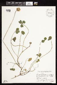 920663[1079428]Smith, Welby 117141986-06-12 United States, Minnesota, Pipestone, Prairie Coteau Scientific Natural Area. Pipestone County...Prairie Coteau State Scientific and Natural Area (Aetna Prairie); on the northwest side of State Highway 23, about 2-1/2 miles northeast of Holland...NW1/4 SE1/4 section 32, T 108N R 44W. 108N 44W 32, 44.1152778 -96.1522222 |
MIN:Plants | 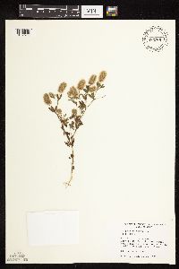 435843[1078960]Judziewicz, E. 107721993-09-10 United States, Minnesota, Pine, Pine Co.; at HQ. St. Croix State Park. T40N-R18W, sec. 21, NW; near headquarters, on bluff above St. Croix River.;Saint Croix State Park;040N;18W;21, 45.9430274 -92.6017754 |
MIN:Plants |  Trifolium campestre Schreber 834869[1079038]Juhnke, C. 360 CMJ1993-08-17 United States, Minnesota, Fillmore, Forestville State Park. Forestville State Park. Fillmore County...T102N R12W Sec.20 NE NE SE. Along trail from parking lot to Mystery Cave entrance 2. 102N 12W 20, 43.6236562 -92.2986037 |
MIN:Plants |  Trifolium aureum Pollich 52133[1283064]Scott, P. A. 38102013-07-23 United States, Minnesota, Cook, Superior National Forest. Gravel road (FS313) off of Shoe Lake Road. T63N R2E sec. 6 NWSWNW., 47.9689382 -90.2428791 |
MIN:Plants |  143146[1078991]Campbell, Jennie c691896-07-00 United States, Minnesota, Stearns, St. Cloud;;N;;, 45.5582 -94.181183 |
MIN:Plants |  419820[1078993]Lakela, Olga 109801950-07-30 United States, Minnesota, Saint Louis, Hwy #2 near Floodwood;;N;;, 46.92911 -92.919648 |
MIN:Plants |  426007[1078989]Moyle, J. s.n.1955-08-17 United States, Minnesota, Morrison, along hwy at Ft. Ripley;;N;;, 46.145257 -94.352158 |
MIN:Plants |  435014[1078949]Porupsky, A. 921999-07-15 United States, Minnesota, Morrison, Crane Meadows National Wildlife Refuge; NWSE 30-40-31; Near mailbox;Crane Meadows National Wildlife Refuge;040N;31W;30, 45.9338958 -94.2515644 |
MIN:Plants |  435023[1078956]Harris, Fred 941601994-07-28 United States, Minnesota, Olmsted, Olmsted Co.; Chester Woods County Park; SW1/4 of NE1/4 of NE1/4 Sect. 18 T106N R12W;Chester Woods County Park;106N;12W;18, 43.9848602 -92.3088434 |
MIN:Plants |  440181[1078947]Myhre, K. 40741993-07-08 United States, Minnesota, Pine, Pine Co. Located 4 mi NW of Head of the Rapids Landing on the St. Croix River; T40N R19W NE1/4 of NE1/4 of SEc 17;Saint Croix State Park;040N;19W;17, 45.9536826 -92.7431049 |
MIN:Plants |  444405[1078957]Smith, Welby 196711991-07-17 United States, Minnesota, Itasca, Itasca Co.; Scenic State Park, about 5 miles southeast of Big Fork; T 60W R 25W SW1/4 of SW1/4 of sec 6;Scenic State Park;060N;25W;6, 47.7036095 -93.5733337 |
MIN:Plants |  445827[1078984]Moore, John; Huff, N. 179591945-07-25 United States, Minnesota, Morrison, 6 1/2 mi E of Little Falls;;N;;, 45.976275 -94.227081 |
MIN:Plants |  448374[1078986]Moore, John; Huff, N. 189141946-08-02 United States, Minnesota, Morrison, 3 mi S of Little Falls;;N;;, 45.932918 -94.362502 |
MIN:Plants |  505270[1078958]Smith, Welby 207911992-07-13 United States, Minnesota, Wadena, Dry Sand Lake Wildlife Management Area. Wadena County...In Dry Sand Lake State Wildlife Management Area, on the west side of CSAH 30, about 2.5 miles south of Oylen...T 135N R 33W NW1/4 of SW1/4 of Sec 1. 135N 33W 1, 46.5338889 -94.7980556 |
MIN:Plants |  553640[1078983]Ownbey, Gerald 25981958-07-20 United States, Minnesota, Hubbard, hwy 71-92 near where it crosses Kabekona Creek, ca 16 mi S of Bemidji;;N;;, 47.240449 -94.876758 |
MIN:Plants |  592011[1078985]Moore, John 267961965-10-15 United States, Minnesota, Isanti, house site, NE1/4 S16, Athens Twp, Cedar Creek Natural History Area;Cedar Creek National History Area;034N;23W;16, 45.4357238 -93.2148194 |
MIN:Plants |  592390[1078990]Westkaemper, Remberta s.n.1964-06-00 United States, Minnesota, Stearns, Stearns Co. St. Joseph;;124N;29W;, 45.564083 -94.30917 |
MIN:Plants |  603638[1078992]Moore, John; Moore, Marjorie 269561966-07-22 United States, Minnesota, Isanti, old house site NE1/4 Sec.;Cedar Creek Ecosystem Preserve;034N;23W;16, 45.4357238 -93.2148194 |
MIN:Plants |  606891[1078994]Morley, T. 12191968-07-29 United States, Minnesota, Pine, Pine Co.; N outskirts of Willow River;;N;;, 46.325318 -92.83901 |
MIN:Plants |  607467[1078982]Ownbey, Gerald; Hsi, Yu-tseng [Eugene] 42031968-08-19 United States, Minnesota, Aitkin, Aitkin Co. McGregor;;N;;, 46.606615 -93.313842 |
MIN:Plants |  616415[1078987]Moore, John; Moore, Marjorie 4311969-08-08 United States, Minnesota, Crow Wing, Crow Wing Natural History Area; W line of the NW1/4 S7, Garrison Twp;Crow Wing Natural Area;044N;28W;7, 46.3085901 -93.9264425 |
MIN:Plants |  630439[1078976]Thieret, J. 448541973-08-17 United States, Minnesota, Clearwater, Biological Station, Lake Itasca, Itasca State Park;Itasca State Park;143N;36W;, 47.226173 -95.194392 |
MIN:Plants |  631578[1078975]Richards, Donald; et al. 21361972-06-28 United States, Minnesota, Itasca, Itasca County...along co hwy 19, N shore of Deer Lake, 18 mi NW of Grand Rapids;;;;, 47.37852 -93.66181 |
MIN:Plants |  635054[1078971]Lindayen, T. 1011972-07-25 United States, Minnesota, Washington, T32N, R21W, NE1/4 S20, ca 1/2 mifrom jnc of hwy 97 & 61 (due S of Hwy 61);;032N;21W;20, 45.2467108 -92.988587 |
MIN:Plants |  687287[1078978]Wheeler, Gerald; Glaser, Paul 17161977-06-27 United States, Minnesota, Itasca, Coll. site no. 59. NW1/4 SW1/4 S22, T55N, R25W; Grand Rapids, near entrance to Grand Rapids Forestry Station;;055N;25W;22, 47.2318503 -93.5013975 |
MIN:Plants |  689988[1078977]Ownbey, Gerald 57011977-07-26 United States, Minnesota, Hubbard, E side of US Rte 71, 2.3-2.5 mi S of its jnc with Minn Rte 34 in Park Rapids;;N;;, 46.885521 -95.060692 |
MIN:Plants |  700936[1078979]Dorio, J. 5771977-07-19 United States, Minnesota, Morrison, Lake Alexander, ca 7 mi N Randall on co rd 6, near lake, T131N, R30W, S6;;131N;30W;6, 46.1870677 -94.5062348 |
MIN:Plants |  701076[1078980]Dorio, J. 3771977-06-27 United States, Minnesota, Morrison, Ripley Esker, ca 3 mi NE of Camp Ripley jnc, T42N, R31W, S19;Ripley Esker Scientific Natural Area;042N;31W;19, 46.1062834 -94.30299 |
MIN:Plants |  701481[1078981]Dorio, J. 4651977-07-07 United States, Minnesota, Morrison, Co.: Morrison ... Sandhill Crane Meadow, 4.5 mi W of Buckman on Hwy 34, T39N, R31W, S3 & 4;Crane Meadows National Wildlife Refuge;039N;31W;, 45.904403 -94.1885788 |
MIN:Plants |  717846[1078988]Lustig, K. 301977-08-09 United States, Minnesota, Anoka, Anoka Co. hwy 60, 1/2 mi E of Hwy 65, T32N, R23W, S16, 17;;032N;23W;, 45.2625236 -93.2141124 |
MIN:Plants | 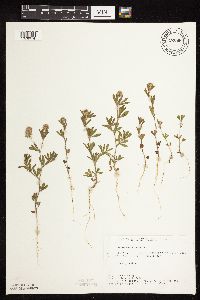 722668[1078974]Lustig, K. 6251979-07-05 United States, Minnesota, Anoka, 18 mi SE of Cambridge;Boot Lake Scientific Natural Area;033N;22W;, 45.34066 -93.08146 |
MIN:Plants | 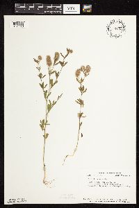 725002[1078973]Smith, Welby 30141980-07-26 United States, Minnesota, Anoka, Anoka Co. T33N, R22W; SE1/4 S34, Carlos Avery Wildlife Management Area;Carlos Avery Wildlife Management Area;033N;22W;34, 45.2180874 -93.0704007 |
MIN:Plants | 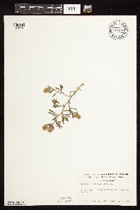 737259[1078996]Kachman, R. 3211980-07-27 United States, Minnesota, Mower, Along hwy 56 ca 3 mi W of Adams;;N;;, 43.577168 -92.774172 |
MIN:Plants | 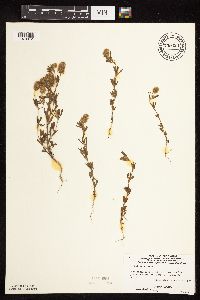 739323[1078972]Stackler, S. 17601976-07-02 United States, Minnesota, Carlton, Skunk Creek Basin, both sides of hwy 106, near roads edge, ca 6 mi E 1/4 mi N Barnum (T46N, R18W, S36 & R17W, S31);;;;, 46.425336 -92.5637492 |
MIN:Plants |  758701[1078959]Smith, Welby 7118A1982-08-07 United States, Minnesota, Wright, ca 1.25 mi S of Hasty, on the shoulder of co hwy 8, NW1/4 NW1/4 S28, T122N, R26W;;122N;26W;28, 45.3475816 -93.9629269 |
MIN:Plants |  772224[1078995]Boe, J. 17481980-07-29 United States, Minnesota, Lake of the Woods, Path to Brown's Lake due S of old Forestry house; S4, R35W, T159N (E section line);;159N;35W;4, 48.6197049 -95.1591975 |
MIN:Plants |  774520[1078997]Monson, Paul 56781983-07-26 United States, Minnesota, Saint Louis, Voyageurs National Park, R20W, T68N, S11; Ash Trail ca 1.3 mi W of VNP road;Voyageurs National Park;068N;20W;11, 48.3904455 -92.8649865 |
MIN:Plants |  829212[1078954]Myhre, K. 26591992-07-09 United States, Minnesota, Cass, Cass Co. Located along the shore of Tadpole Lake; T141N R28W NE/14 of SW1/4 of Sec 22;Chippewa National Forest / Leech Lake Indian Reservation;141N;28W;22, 47.0153931 -94.2152168 |
MIN:Plants |  831039[1078955]Cholewa, A. 20581992-06-00 United States, Minnesota, Aitkin, Aitkin Co. Savanna State Park, along highway to park, just SW of headquarters. T50N R22 Sec.18.;Savanna Portage State Park;050N;22W;18, 46.8169926 -93.177937 |
MIN:Plants |  831060[1078948]Cholewa, A. 21141993-06-01 United States, Minnesota, Anoka, Anoka Co. Carlos Avery Wildlife Management Area, vicinity of Wiregrass Marsh, ca. 2 mi S of Administration bldg.;Carlos Avery Wildlife Management Area;;;, 45.238544 -93.124721 |
MIN:Plants |  833077[1078951]Myhre, K. 24071992-06-29 United States, Minnesota, Cass, Cass Co. Located 1 mi NW of the town of Pine River; T138N R30W SE1/4 of SE1/4 of sec.26;;138N;30W;26, 46.7402609 -94.4407642 |
MIN:Plants |  834146[1078952]Smith, Welby 197581991-07-19 United States, Minnesota, Todd, Staples Wildlife Management Area. Todd Co. Staples State Wildlife Management Area, about 4 mi S of Staples (town). In gravel parking area; Todd Co. Staples State Wildlife Management Area, about 4 mi S of Staples (town). In gravel parking area; T133N R33W SWNE Sec 36.. 133N 33W 36, 46.2936096 -94.7861099 |
MIN:Plants |  836136[1078953]Smith, Welby 172711990-07-17 United States, Minnesota, Morrison, Camp Ripley Military Reservation. Camp Ripley Military Reservation Morrison Co. Along East Boundary Road, about 2.5 km N of the airfield. UTM: 394700E 510 Camp Ripley Military Reservation Morrison Co. Along East Boundary Road, about 2.5 km N of the airfield. UTM: 394700E 5107700N T131N R30W SE1/4 of NW1/4 of Sec 32. 131N 30W 32, 46.1145839 -94.4846274 |
MIN:Plants |  Trifolium aureum Pollich 136655[1079020]Oestlund, O. s.n.1875-00-00 United States, Minnesota, Hennepin, Minneapolis;;N;;, 44.970736 -93.268643 |
MIN:Plants |  Trifolium aureum Pollich 143060[1079007]Moyer, Lycurgus 189 United States, Minnesota, western Minnesota;;;;, 46.219745 -96.735645 |
MIN:Plants |  Trifolium aureum Pollich 143505[1079008]Lugger, O. s.n.1891-07-25 United States, Minnesota, Ramsey, St. Anthony Park [St. Paul neighborhood near U of M];;029N;23W;, 44.983574 -93.195102 |
MIN:Plants |  Trifolium aureum Pollich 143506[1079022]Lugger, O. s.n.1891-07-25 United States, Minnesota, Ramsey, St. Anthony Park [St. Paul neighborhood near U of M];;029N;23W;, 44.983574 -93.195102 |
MIN:Plants |  Trifolium aureum Pollich 16572[1079001]Dahlke, L. 391971-07-07 United States, Minnesota, Becker, Itasca State park, along state hwy 113, 2.6 mi W of its jnc with US hwy71;Itasca State Park;142N;36W;, 47.15285 -95.203282 |
MIN:Plants |  Trifolium aureum Pollich 306654[1079011]Stevenson, J. 2851912-08-11 United States, Minnesota, Itasca, Grand Rapids;;N;;, 47.225976 -93.523348 |
MIN:Plants |  Trifolium aureum Pollich 347252[1079021]Osevskey, J. s.n.1938-07-07 United States, Minnesota, Carlton, Holyoke;;N;;, 46.467443 -92.388528 |
MIN:Plants |  Trifolium aureum Pollich 353820[1079009]Lakela, Olga 25691938-07-15 United States, Minnesota, Saint Louis, between high hills, 32nd Ave W at Skyline Parkway, Duluth;;N;;, 46.765565 -92.150778 |
MIN:Plants |  Trifolium aureum Pollich 360117[1079017]Alaspa, E.; Alaspa, H. s.n1940-07-27 United States, Minnesota, Carlton, 4 mi N of Cloquet;;N;;, 46.760706 -92.46073 |
MIN:Plants |  Trifolium aureum Pollich 362873[1079018]Moyle, J. 34641940-07-18 United States, Minnesota, Lake, near Split Rock R.;;N;;, 47.194403 -91.383102 |
MIN:Plants |  Trifolium aureum Pollich 391771[1079013]Lakela, Olga 60231945-07-08 United States, Minnesota, Saint Louis, small island in Duluth Harbor, Duluth;;N;;, 46.755054 -92.0901 |
MIN:Plants |  Trifolium aureum Pollich 392931[1079014]Lakela, Olga; et al. 64771946-07-01 United States, Minnesota, Saint Louis, Sandbar Island in Duluth Harbor, Duluth;;N;;, 46.771987 -92.096966 |
MIN:Plants |  Trifolium aureum Pollich 395234[1079019]Loula, E. 91938-07-11 United States, Minnesota, Cook, T61N, R1W, S32, between Cascade and Grand Marais;North Shore / Superior National Forest;061N;01W;32, 47.7242882 -90.4795152 |
MIN:Plants |  Trifolium aureum Pollich 421048[1079016]Lakela, Olga 105781950-07-01 United States, Minnesota, Saint Louis, Hwy No.2 E of St. Louis River bridge;;N;;, 46.736238 -92.159012 |
MIN:Plants |  Trifolium aureum Pollich 428168[1079002]Myhre, K. 23151992-06-22 United States, Minnesota, Cass, Cass Co. Located 1.2 mi E of Pulvers Lake; T135N R32W NW1/4 of SW1/4 of Sec 26;;135N;32W;26, 46.4777142 -94.6856679 |
MIN:Plants |  Trifolium aureum Pollich 436477[1078999]Smith, Welby 195421991-07-16 United States, Minnesota, Koochiching, Koochiching State Forest. Koochiching County...On the north side of TH 65, aobut 18 miles northwest of Silverdale... T 65N R 24W SE1/4 of NE1/4 of Sec 3. 065N 24W 3, 48.1500015 -93.4186096 |
MIN:Plants |  Trifolium aureum Pollich 446383[1079015]Moore, John; Huff, N. 187381946-07-17 United States, Minnesota, Pine, Pine Co. along the Kettle River at Sandstone;Banning State Park;N;;, 46.145255 -92.860815 |
MIN:Plants |  Trifolium aureum Pollich 478443[1079005]Smith, Welby 171441990-07-04 United States, Minnesota, Pine, Pine Co.; On the Hinckly [sic] Bike Trail where it crosses CSAH 26 at Friesland; T 42N R 21W SE1/4 of SE1/4 of Sec 25;;042N;21W;25, 46.085556 -92.9327774 |
MIN:Plants |  Trifolium aureum Pollich 506766[1079000]Smith, Welby 188841991-06-21 United States, Minnesota, Aitkin, Hill River State Forest. Aitkin Co.; abut 3 mi E of Hill City; along Trunk Highway 200; T52N R25W SE1/4 of NE1/4 Aitkin Co.; abut 3 mi E of Hill City; along Trunk Highway 200; T52N R25W SE1/4 of NE1/4 of Sec 17. 052N 25W 17, 46.9949989 -93.5311127 |
MIN:Plants |  Trifolium campestre Schreber 508568[1079031]Myhre, K. 42361993-07-22 United States, Minnesota, Pine, Pine County...Located 1 mi NW of Cedar Lake...by Cedar Creek...T40N R20W SE1/4 of NE1/4 of Sec 30;;040N;20W;30, 45.9250921 -92.8882055 |
MIN:Plants |  Trifolium aureum Pollich 543197[1079010]Lakela, Olga; Davidson, Donald 215411957-07-24 United States, Minnesota, Cook, Lake Co, ridge above creek bed, end of trail, S35, T63, R5 [this actually in Cook Co.];Boundary Waters Canoe Area Wilderness / Superior National Forest;063N;05W;35, 47.9018236 -89.7757529 |
MIN:Plants |  Trifolium aureum Pollich 583564[1079012]Kellner, H. 1261956-06-29 United States, Minnesota, Lake, Lake Co, Station 5, near top of Lafayette Bluff [this is near mouth of Encampment River];North Shore;053N;10W;11, 47.09341 -91.57419 |
MIN:Plants |  Trifolium aureum Pollich 616725[1079023]Moore, John; Moore, Marjorie 2131969-07-01 United States, Minnesota, Crow Wing, along path, E shore Chandler Lake, SW1/4 S22, Garrison Twp;Crow Wing Natural Area;044N;28W;22, 46.2789902 -93.8633363 |
Google Map
Google Maps is a web mapping service provided by Google that features a map that users can pan (by dragging the mouse) and zoom (by using the mouse wheel). Collection points are displayed as colored markers that when clicked on, displays the full information for that collection. When multiple species are queried (separated by semi-colons), different colored markers denote each individual species.