University of Minnesota
http://www.umn.edu/
612-625-5000
http://www.umn.edu/
612-625-5000
Minnesota Biodiversity Atlas
Bell Museum
Dataset: MIN-Plants
Taxa: Viburnum
Search Criteria: excluding cultivated/captive occurrences
Bell Museum plants | |
 MIN:Plants | Viburnum rafinesquianum J.S. Schultes 477476[]Smith, Welby 291682001-06-02 United States, Minnesota, Wright, Wright County ... Harry Larson County Forest, about 7 miles W-NW of Monticello ... T 122N R 26W SW1/4 of SW1/4 of Sec 35;Harry Larson County Forest;122N;26W;35, 45.3352778 -93.9280556 |
MIN:Plants | 462043[]Smith, Welby 259351995-09-04 United States, Minnesota, Steele, About 4 miles northwest of Claremont. NW1/4 of NW1/4 of section;Rice Lake State Park;107N;19W;12, 44.0897222 -93.0647222 |
MIN:Plants | Viburnum edule (Michaux) Rafinesque 907605[]Smith, Welby; et al. 309522008-06-19 United States, Minnesota, Cook, Cook County...About 3 miles south of McFarland Lake, in Grand Portage State Forest...T 64N R 3E NW1/4 of NW1/4 of Sec 27;Grand Portage State Forest;064N;03E;27, 48.0030556 -90.0505556 |
MIN:Plants | Viburnum nudum var. cassinoides (L.) Torrey & A. Gray 510382[]US Nat. Arboretum staff 1974-281974-00-00 Canada, Nova Scotia, Queens Cnty |
MIN:Plants | 510370[]Arboretum, Cary 73-171973-00-00 United States, New York, Dutchess, Dutchess Co. |
MIN:Plants | 480624[]Smith, Welby 174021990-07-23 United States, Minnesota, Steele, Steele County ... Kaplan Woods City Park, on the south side of Owatonna ... T107N R20W NE1/4 of NW1/4 of Sec 21;;107N;20W;21, 44.0644444 -93.235 |
MIN:Plants | 439225[]Cochran, Philip; et al. s.n.2002-10-10 United States, Minnesota, Winona, Winona Co, Farmer's Community Park, near Garvin Brook (T107N,R8W,S8);Dorer Memorial Hardwood State Forest;107N;08W;08, 44.0851132 -91.810374 |
MIN:Plants | 429270[]Smith, Welby 285302000-06-15 United States, Minnesota, Otter Tail, Almora Wildlife Management Area. Otter Tail County ... Almora State Wildlife Management Area, about 0.75 mile west of Almora ... T 132N R 37W SW1/4 of NE1/4 of Sec 18. 132N 37W 18, 46.2466667 -95.3786111 |
MIN:Plants | Viburnum rafinesquianum J.S. Schultes 920214[]Smith, Welby 258421995-08-13 United States, Minnesota, Cook, Boundary Waters Canoe Area Wilderness / Superior National Forest. Cook County ... Boundary Waters Canoe Area Wilderness, Superior National Forest ... West end of Chaser Lake ... T63N R5W NE1/4 of SW1/4 of Sec 4. 063N 05W 4, 47.9655556 -90.9716667 |
MIN:Plants | Viburnum edule (Michaux) Rafinesque 918172[]Gerdes, Lynden 59572009-07-14 United States, Minnesota, Cook, Superior National Forest. T64N R04E S28NWNWNENE. Cook County, MN. Superior National Forest. Pigeon River Purchase Unit. Approximately 0.35 miles southwest of the Pigeon River and Swamp River confluence...NAD 83 / 728689 / 5320831. 064N 04E 28, 47.9997222 -89.9341667 |
MIN:Plants | 439223[]Cochran, Philip; et al. s.n.2002-10-10 United States, Minnesota, Winona, Winona Co, Farmer's Community Park, near Garvin Brook (T107N,R8W,S8);Dorer Memorial Hardwood State Forest;107N;08W;08, 44.0851132 -91.810374 |
MIN:Plants | 510374[]US Nat. Arboretum staff 1976-511976-00-00 United States, New Jersey, Burlington, Burlington Co. |
MIN:Plants | 910984[]Smith, Welby 244931994-06-27 United States, Minnesota, Stearns, Stearns County... In Birch Lake State Forest, about 4 miles south of Grey Eagle... T127N R33W NE1/4 of NE1/4 of Sec 36;Birch Lakes State Forest;127N;33W;36, 45.7730556 -94.7705556 |
MIN:Plants | Viburnum rafinesquianum J.S. Schultes 913091[]Smith, Welby 241091994-05-17 United States, Minnesota, Le Sueur, Chamberlain Woods Scientific Natural Area. Le Sueur County...In Chamberlain Woods State Scientific and Natural Area; about one mile north of Ottawa...T 111N R26W SW1/4of SW1/4 of Sec 22. 111N 26W 22, 44.4008333 -93.9472222 |
MIN:Plants | Viburnum rafinesquianum J.S. Schultes 386940[]Cholewa, A. 25782006-06-07 United States, Minnesota, Beltrami, Chippewa National Forest. Beltrami County, Chippewa National Forest, South Twin Lake boat access, about 4 miles north of County Road 20 on forest road. T147N R31W Sec 2 NW1/4 of NE1/4.. 147N 31W 2, 47.5772972 -94.5780033 |
MIN:Plants | 510369[]US Nat. Arboretum staff s.n.1981-00-00 United States, Maryland, Allegany, Alleghany Co. |
MIN:Plants | 490480[]Smith, Welby 266071997-06-12 United States, Minnesota, Itasca, Itasca County ... Along Hwy 1 where it crosses the Big Fork River ... T 62N R 25W SE1/4 of SW1/4 of Sec 23;Leech Lake Indian Reservation;062N;25W;23, 47.8408333 -93.5027778 |
MIN:Plants | 762201[]Smith, Welby 294972005-05-31 United States, Minnesota, Freeborn, Freeborn County ... Big Island State Park, about 3 miles southeast of Albert Lea ... T102N R21W NE1/4 of NE1/4 of Sec 23;Big Island Scientific Natural Area;102N;21W;23, 43.6272222 -93.3125 |
MIN:Plants | 477408[]Lee, Michael MDL12841996-06-12 United States, Minnesota, Dakota, Pine Bend Bluffs Scientific Natural Area. Dakota County ... Along the Mississippi River at Pine Bend ... bluffs immediately above the river ... T27N R22W SW1/4 SW1/4 NW1/4 Sec. 35. 027N 22W 35, 44.7809705 -93.0216457 |
MIN:Plants | 493436[]Smith, Welby 273041998-06-29 United States, Minnesota, Itasca, Itasca County...At the northwest end of Island Lake, about 3 mi south of Northome...T 150N R 28W SW1/4 of SW1/4 of sec 5;Chippewa National Forest;150N;28W;05, 47.8316667 -94.2625 |
MIN:Plants | 479195[]Kaul, R. 72811994-05-30 United States, Minnesota, Steele, Steele Co.; along Straight River south of Morehouse Park.;;107N;20W;, 44.0661118 -93.2260713 |
MIN:Plants | Viburnum rafinesquianum J.S. Schultes 914597[]Smith, Welby 225041993-06-18 United States, Minnesota, Douglas, Douglas County...Lake Carlos State Park, about 6 miles north of Alexandria... T129N R 37W SE1/4 of SW 1/4 of Sec 9;Lake Carlos State Park;129N;37W;09, 45.9958333 -95.3469444 |
MIN:Plants |  475270[1334372]Smith, Welby 278511999-05-30 United States, Minnesota, Ramsey, Ramsey County ... Snail Lake County Park in Shoreview ... T 30N R 23W SW1/4 of SE1/4 of Sec 24;Snail Lake Vadnais Lake County Park;030N;23W;24, 45.0633333 -93.1161111 |
MIN:Plants | 479217[]Kaul, R. 72921994-07-16 United States, Minnesota, Steele, Steele Co.; near Straight River south of Morehouse Park, Owatonna.;;107N;20W;, 44.0661118 -93.2260713 |
MIN:Plants |  462312[1334376]Juhnke, C. 269 CMJ FRO1999-05-21 United States, Minnesota, Goodhue, Frontenac State Park. Goodhue County ... along Hill Ave, south of Rattlesnake Bluff;Frontenac State Park;112N;13W;05, 44.5351964 -92.3999731 |
MIN:Plants | 904594[]Smith, Welby 260891996-06-03 United States, Minnesota, Rock, Rock County ... Blue Mounds State Park, about 3 miles N-NE of Luverne... Rock Creek...T103N R45W NW1/4 of NW1/4 of Sec24;Blue Mounds State Park;103N;45W;24, 43.7163889 -96.1897222 |
MIN:Plants | 914560[]Smith, Welby 225181993-06-18 United States, Minnesota, Douglas, Douglas County...Lake Carlos State Park, about 6 miles north of Alexandria... T129N R 37W SE1/4 of SW 1/4 of Sec 9;Lake Carlos State Park;129N;37W;09, 45.9958333 -95.3469444 |
MIN:Plants |  Viburnum edule (Michaux) Rafinesque 462045[1329977]Smith, Welby 274871998-08-04 United States, Minnesota, Cook, Cook County ... On the north side of Big Susie Island in Lake Superior ... T 64N R 7E SE1/4 of SE1/4 of Sec 32;North Shore / Susie Islands, The Nature Conservancy;063N;07E;32, 47.9783325 -89.5741653 |
MIN:Plants |  Viburnum rafinesquianum var. rafinesquianum J.S. Schultes 456134[1334390]Smith, Welby 288262000-07-26 United States, Minnesota, Aitkin, Aitkin County ... Savanna Portage State Park; about 1 mile west of Shumway Lake ... T 50N R 22W SW1/4 of SE1/4 of Sec 7;Savanna Portage State Park;050N;22W;07, 46.8286111 -93.1744444 |
MIN:Plants | 913128[]Scott, P. 27022006-08-24 United States, Minnesota, Lake, Lake Co. ...S. Kawishiwi River, SNF. T62N R11W sec. 23 SENE.;Superior National Forest;062N;11W;23, 47.8413189 -91.6937992 |
MIN:Plants | 475271[]Smith, Welby 288272000-07-26 United States, Minnesota, Aitkin, Aitkin County ... Savanna Portage State Park; about one mile west of Shumway Lake ... T50N R22W SW1/4 of SE1/4 of Sec 7;Savanna Portage State Park;050N;22W;07, 46.8286095 -93.1744461 |
MIN:Plants | Viburnum rafinesquianum J.S. Schultes 463585[]Lee, Michael MDL30762001-07-26 United States, Minnesota, Cook, North Shore / Superior National Forest. Cook County ... Superior National forest. On Leveaux Mountain three miles northeast of Tofte ... T59N R4W SW1/4 of SW1/4 Sec.1. 059N 04W 1, 47.6230333 -90.7774343 |
MIN:Plants | 477353[]Lee, Michael MDL11871996-05-28 United States, Minnesota, Winona, Winona County ... upper reaches of small valley three miles north of Rushford ... T105N R8W NW1/4 SW1/4 Sec. 26;Dorer Memorial Hardwood State Forest;105N;08W;26, 43.8683871 -91.7497521 |
MIN:Plants | 510378[]US Nat. Arboretum staff 77-611977-00-00 United States, Maryland, Montgomery, Montgomery Co. |
MIN:Plants | 540873[]Smith, Welby 249001994-07-26 United States, Minnesota, Aitkin, Aitkin County ... Savanna Portage State Park; about one mile west of Shumway Lake ... T 50N R 22W SW1/4 of SE1/4 of Sec;Savanna Portage State Park;050N;22W;07, 46.8286095 -93.1744461 |
MIN:Plants | 910709[]Rowe, Erika ERR2852007-08-30 United States, Minnesota, Hubbard, Hubbard County...3 miles NNE of Laporte; 1.85 miles east of Cty Rd 36; 85 meters east of old railroad bed turned snowmobile trail...T144N R32W SENE S30. 144N 32W 30, 47.2608333 -94.7736111 |
MIN:Plants | 904516[]Smith, Welby 256701995-06-12 United States, Minnesota, Le Sueur, Le Sueur County ... About one mile north of Ottawa ... T111N R26W SW1/4 of SW1/4 of Sec 22;;111N;26W;22, 44.3911111 -93.9438889 |
MIN:Plants | Viburnum nudum var. cassinoides (L.) Torrey & A. Gray 510381[]US Nat. Arboretum staff 77-601977-00-00 Canada, Quebec, Parc de la Verendrye |
MIN:Plants | 510380[]US Nat. Arboretum staff 1974-291974-00-00 United States, Maryland, Anne Arundel, [no further data] |
MIN:Plants | 919222[]Gerdes, Lynden; et al. 59062009-08-25 United States, Minnesota, Cook, Boundary Waters Canoe Area Wilderness / Superior National Forest. T66N R05W S12SWNENWSW. Cook County, MN. Superior National Forest. Boundary Waters Canoe Area Wilderness. Saganaga Lake. Munker Island.. 066N 05W 12, 48.2151183 -90.9125223 |
MIN:Plants | 515408[]Scott, P. 13142001-08-10 United States, Minnesota, Cook, COOK CO ... Voyageur Island, Saganaga Lake, BWCAW. T66N R5W sec.1 SENESW.;Boundary Waters Canoe Area Wilderness / Superior National Forest;066N;05W;01, 48.2286502 -90.910713 |
MIN:Plants | 439224[]Cochran, Philip; et al. s.n.2002-09-09 United States, Minnesota, Winona, Winona Co, Saint Mary's University campus (T107N,R7W,S29)...bluff along east side of Yon's Road.;;107N;07W;29, 44.0415032 -91.6901248 |
MIN:Plants | 510375[]US Nat. Arboretum staff 77-631977-00-00 United States, Maryland, Montgomery, Montgomery Co. |
MIN:Plants | 498986[]Smith, Welby 266031997-06-12 United States, Minnesota, Beltrami, Beltrami County ... Along Hwy 71 about 3 miles SE of Funkley ... T149N R30W NE1/4 of NE1/4 of Sec 4;;149N;30W;04, 47.7577778 -94.4861111 |
MIN:Plants | 567994[]Gerdes, Lynden 51072006-05-23 United States, Minnesota, Itasca, George Washington State Forest. T62N R24W S08SWSWSW Itasca County ... George Washington State Forest. Approximately 9.09 miles ENE of Effie, MN and 0.03 mile E of Cty. Rd. 525.. 062N 24W 8, 47.873022 -93.4337424 |
MIN:Plants | 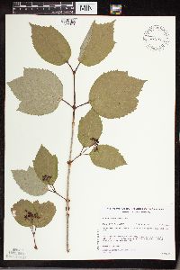 Viburnum edule (Michaux) Rafinesque 482141[1329976]Gerdes, Lynden 25411998-05-29 United States, Minnesota, Cook, Boundary Waters Canoe Area Wilderness / Superior National Forest. T65N R01W S34NWNW. Cook County; Superior National Forest, BWCAW, Caribou Rock Hiking Trail vicinity of Duncan Lake.. 065N 01W 34, 48.06986 -90.43821 |
MIN:Plants | 461870[]Kaul, R. 62321988-08-24 United States, Minnesota, Steele, Steele Co.; along the Straight River near the Lemond Road.;;107N;20W;, 44.0661118 -93.2260713 |
MIN:Plants | Viburnum rafinesquianum J.S. Schultes 920174[]Smith, Welby 221841993-05-20 United States, Minnesota, Otter Tail, Inman Wildlife Management Area. Otter Tail County...Inman State Wildlife Management Area, about 7 miles south of Deer Creek (town)...T133N R37W SE1/4 of SE1/4 of Sec 33. 133N 37W 33, 46.2847222 -95.3463889 |
MIN:Plants | 473163[]Lee, Michael MDL22591998-07-19 United States, Minnesota, Wabasha, Dorer Memorial Hardwood State Forest. Wabasha Co.; Upper reaches of West Indian Creek 3-1/2 miles north-northeast of Plainview; north-facing bluff below dolomite cliffs; T109N R11W NW1/4 of NW1/4 of SE1/4 Sec. 28. 109N 11W 28, 44.2149758 -92.1397725 |
MIN:Plants | 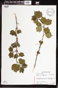 Viburnum edule (Michaux) Rafinesque 918169[1329974]Gerdes, Lynden 57212009-06-03 United States, Minnesota, Cook, T64N R03E S12SWNENWSW. Cook County, MN. Superior National Forest. South Fowl Cliff...NAD 83 / 723097 / 5325377;Superior National Forest;064N;03E;12, 48.0425 -90.0066667 |
MIN:Plants | 915832[]Whitfeld, T.J.S. 6652006-05-25 United States, Minnesota, Hubbard, Hubbard County...1/2 mi S of Blacksmith Lake; 2 mi SE of Coon Lake Forest Road...UTM (NAD83): E344327 N5218696;;142N;35W;24, 47.1033333 -95.0516667 |
MIN:Plants | 510377[]Arboretum, Cary 73-161973-00-00 United States, New York, Dutchess, Dutchess Co. |
MIN:Plants | 493670[]Smith, Welby 266061997-06-12 United States, Minnesota, Koochiching, Koochiching County ... On the north side of Hwy 1, about 3 mi east of Northome ... T 151N R 28W SW1/4 of SW1/4 of Sec 24;;151N;28W;24, 47.875 -94.1861115 |
MIN:Plants | 453133[]Smith, Welby 290432000-08-24 United States, Minnesota, Sherburne, Sherburne National Wildlife Refuge. Sherburne County ... Sherburne National Wildlife Refuge. Along the Mahnomen Trail on the north side of Rice Lake ... T 35N R 27W NW1/4 of NW1/4 of Sec 26. 035N 27W 26, 45.4980545 -93.6511078 |
MIN:Plants | 489623[]Smith, Welby 270481998-05-12 United States, Minnesota, Koochiching, Koochiching County...Where County Road 5 crosses the Big Fork River at Craigville...T 63N R 26W SE1/4 of NW1/4 of Sec 36;Koochiching State Forest;063N;26W;36, 47.9069443 -93.6108322 |
MIN:Plants | 479196[]Kaul, R. 63941989-06-15 United States, Minnesota, Clearwater, Clearwater Co.; east side of Lake Itasca just north of the biological station.;Itasca State Park;143N;36W;, 47.19557 -95.2332161 |
MIN:Plants | 906148[]Clancy, J.; et al. 52008-09-27 United States, Minnesota, Hennepin, Minnehaha Falls Park. Hennepin County, Minnehaha Falls Park, approximately 0.25 miles south east of Falls, along...Minnehaha Creek, 100 feet south of Den Pen Area Bridge. 1/2SE of 1/4NE of Section 18, Township 28N, Range 23W.. 028N 23W 18, 44.9147222 -93.2097222 |
MIN:Plants | 493284[]Smith, Welby 266041997-06-12 United States, Minnesota, Itasca, Itasca County ... along Hwy 71 about 4 miles NE of Funkley ... T 150N R 29W NW1/4 of NW1/4 of sec 9;;150N;29W;09, 47.8294449 -94.3694458 |
MIN:Plants | 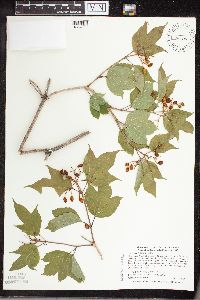 505598[1334365]Smith, Welby 287052000-07-11 United States, Minnesota, Aitkin, Rice Lake National Wildlife Refuge. Aitkin County ... Rice Lake National Wildlife Refuge; about 5 miles S-SW of McGregor ... T 47N R 24W SE1/4 of SW1/4 of Sec 23. 047N 24W 23, 46.538887 -93.3422241 |
MIN:Plants | 920324[]Smith, Welby 240001993-09-21 United States, Minnesota, Winona, Winona County ... About 3 miles west of Winona ... T107N R8W NE1/4 of NW1/4 of Sec 24;;107N;08W;24, 44.0622222 -91.7313889 |
MIN:Plants | 461866[]Kaul, R.; et al. 71051992-05-19 United States, Minnesota, Steele, Steele County...along Straight River south of Morehouse Park.;;107N;20W;, 44.0661118 -93.2260713 |
MIN:Plants | 438983[]Smith, Welby 278261999-05-28 United States, Minnesota, Beltrami, Beltrami County...About 3 miles west of Fourtown...T 155N R 37W NW1/4 of NW1/4 of Sec 3;Red Lake Indian Reservation;155N;37W;03, 48.2805556 -95.3994444 |
MIN:Plants | 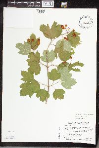 429056[1334375]Smith, Welby 280271999-07-19 United States, Minnesota, Nicollet, Nicollet County ... Fort Ridgely State Park, about 10 miles north of Sleepy Eye ... T111N R32W NE1/4 of NE1/4 of Sec 6;Fort Ridgely State Park;111N;32W;06, 44.4538879 -94.7350006 |
MIN:Plants |  Viburnum rafinesquianum var. rafinesquianum J.S. Schultes 456126[1334393]Smith, Welby 244111994-06-17 United States, Minnesota, Anoka, Rum River County Park. Anoka County ... In Rum River North Regional Park, on the east bank of the Rum River about 4 miles west-southwest of Bethel ... T 34N R 24W NW1/4 of SE1/4 of Sec 32. 034N 24W 32, 45.3897222 -93.3561111 |
MIN:Plants | 453129[]Lake, Roger 99-41999-07-03 United States, Minnesota, Saint Louis, St. Louis County ... Near south-facing bank of Sturgeon River ... T 60N R 21W SE1/4 of NE1/4 of Sec 25;Sturgeon River State Forest;060N;21W;25, 47.6537885 -92.9425476 |
MIN:Plants | 505428[]Smith, Welby 272611998-06-17 United States, Minnesota, Cook, Boundary Waters Canoe Area Wilderness / Superior National Forest. Cook County ... Boundary Waters Canoe Area Wilderness, Superior National Forest, along the Cross River ... T65N R4W SW1/4 of SE1/4 of Sec 27. 065N 04W 27, 48.0802778 -90.7380556 |
MIN:Plants | Viburnum rafinesquianum J.S. Schultes 433644[]US Nat. Arboretum staff 1978-631978-00-00 United States, Minnesota, Crow Wing, Crow Wing Co.;;;;, 46.482374 -94.070874 |
MIN:Plants | Viburnum rafinesquianum J.S. Schultes 489484[]Gerdes, Lynden; et al. 34281999-06-12 United States, Minnesota, Cook, Boundary Waters Canoe Area Wilderness / Superior National Forest. T65N R02E S23SENE Cook County ... Superior National Forest, BWCAW. At the far eastern end of Mountain Lake; on the south side of Moose Mountain.. 065N 02E 23, 48.1001037 -90.1554939 |
MIN:Plants | 920263[]Smith, Welby 222671993-06-03 United States, Minnesota, Sibley, Vale Wildlife Management Area. Sibley County...Vale State Wildlife Management Area; in the valley of High Island Creek, about 2.5 miles southwest of its confluence with the Minnesota River...T 113N R 26W NE1/4 of SW1/4 of Sec 27. 113N 26W 27, 44.5625 -93.9427778 |
MIN:Plants |  Viburnum rafinesquianum var. rafinesquianum J.S. Schultes 482180[1334391]Gerdes, Lynden 28831998-07-08 United States, Minnesota, Cook, T65N R02E S34SENE. Cook County...Superior National Forest, BWCAW. Along Border Route Trail, approx. .25 mile west etc.;Boundary Waters Canoe Area Wilderness / Superior National Forest;065N;02E;34, 48.0710487 -90.1768767 |
MIN:Plants | Viburnum rafinesquianum J.S. Schultes 915758[]Smith, Welby; et al. 313242009-06-29 United States, Minnesota, Cook, Boundary Waters Canoe Area Wilderness / Superior National Forest. Cook County...Boundary Waters Canoe Area Wilderness, Superior National Forest...portage between Gasket Lake and Cam Lake...T 63N R 3W NE1/4 of SE1/4 of sec 6. 063N 03W 6, 47.9647222 -90.7486111 |
MIN:Plants | 456384[]Husveth, J. 95-23051995-09-14 United States, Minnesota, Olmsted, Olmsted Co, T107N R14W NE1/4 of the NE1/4 of S23; along channelized Zumbro River.;;107N;14W;23, 44.0578804 -92.468703 |
MIN:Plants | 429189[]Smith, Welby 271061998-05-18 United States, Minnesota, Hennepin, Hennepin County ... on the north side of State Highway 55, about 4 miles east-southeast of Rockford ... T119N R24W NW1/4 of SW1/4 of Sec 36. 119N 24W 36, 45.0702782 -93.6630554 |
MIN:Plants | Viburnum rafinesquianum J.S. Schultes 904562[]Smith, Welby 26177A1996-06-19 United States, Minnesota, Douglas, Douglas County ... Lake Carlos State Park, about 6.5 miles north of Alexandria ... T129N R37W NE1/4 of NW1/4 of Sec 9;Lake Carlos State Park;129N;37W;09, 46.0022222 -95.3466667 |
MIN:Plants | 690694[]Shane, L. 77-341977-07-11 United States, Maine, Oxford, Oxford County ... at summit of Mt. Sabattus, Lovell Township, 390m |
MIN:Plants | Viburnum rafinesquianum J.S. Schultes 896917[]Smith, Welby 292952002-06-11 United States, Minnesota, Wright, Wright County...Harry Larson County Forest, about 7 miles W-NW of Monticello...T 122N R 26W SW1/4 of SW1/4 of Sec 35;Harry Larson County Forest;122N;26W;35, 45.3352778 -93.9280556 |
MIN:Plants | 477528[]Smith, Welby 172091990-07-12 United States, Minnesota, Fillmore, Fillmore County ... On the southwest side of State Highway 63, about 6 miles northeast of LeRoy ... T101N R13W NW1/4 of NW1/4 of Sec 15. 101N 13W 15, 43.5558319 -92.3866653 |
MIN:Plants | 440850[]Cholewa, A. 24781996-06-05 United States, Minnesota, Washington, Washington Co. Warner Nature Center, approx. 3 air-mi SW from Marine on St. Croix, T31N R20W Sec 15;Warner Nature Center;031N;20W;15, 45.1741873 -92.8250054 |
MIN:Plants | Viburnum edule (Michaux) Rafinesque 196039[]Cheney, L. s.n.1891-06-20 United States, Minnesota, Cook, Grand Marais;North Shore;060N;01E;, 47.750447 -90.334273 |
MIN:Plants | Viburnum edule (Michaux) Rafinesque 196040[]Rosendahl, C. 26341912-08-26 United States, Minnesota, Cook, Along the North shore Kimball Creek. Cook Co.;Grand Portage Indian Reservation / North Shore;061N;02E;, 47.7906709 -90.2059909 |
MIN:Plants | Viburnum edule (Michaux) Rafinesque 225012[]Rosendahl, C.; Butters, F. 44881924-06-30 United States, Minnesota, Cook, In gorge of Caribou River, North Shore, Lake Superior. Cook Co.;North Shore / Superior National Forest;060N;03W;, 47.6774443 -90.7068914 |
MIN:Plants | Viburnum edule (Michaux) Rafinesque 225013[]Rosendahl, C.; Butters, F. 45321924-07-01 United States, Minnesota, Cook, Near mouth of Brule River. Cook Co.;Judge Magney State Park / North Shore;062N;03E;, 47.8498363 -90.0649488 |
MIN:Plants | Viburnum edule (Michaux) Rafinesque 273240[]Rosendahl, C. 59951929-08-10 United States, Minnesota, Cook, Along the W side of Hat Point, Grand Portage Bay;Grand Portage Indian Reservation / North Shore;N;;, 47.9621 -89.650704 |
MIN:Plants | Viburnum edule (Michaux) Rafinesque 294508[]Butters, F.; Buell, Murray 4031932-07-12 United States, Minnesota, Cook, S side of Clearwater Lake. T65N, R1E;Boundary Waters Canoe Area Wilderness / Superior National Forest;065N;01E;, 48.0810547 -90.3151891 |
MIN:Plants | Viburnum edule (Michaux) Rafinesque 351290[]Benner, F.; Benner, J. 6321929-08-21 United States, Minnesota, Cook, 2 mi. E of Grand Portage, on road to Hat Point.;Grand Portage Indian Reservation / North Shore;N;;, 47.963768 -89.641581 |
MIN:Plants | Viburnum edule (Michaux) Rafinesque 351590[]Benner, F.; Benner, J. 5541929-07-27 United States, Minnesota, Cook, 1 mi. E of Grand Portage;Grand Portage Indian Reservation / North Shore;063N;06E;, 47.9584678 -89.7035757 |
MIN:Plants | Viburnum edule (Michaux) Rafinesque 371706[]Lakela, Olga 47851941-08-17 United States, Minnesota, Cook, Shore of Lake Superior at Lutsen. Cook Co.;North Shore / Superior National Forest;060N;03W;, 47.6774443 -90.7068914 |
MIN:Plants | Viburnum edule (Michaux) Rafinesque 393277[]Ownbey, Gerald; et al. 10781948-08-14 United States, Minnesota, Cook, Cook County...East end of Little Brick Island, Susie Islands near Grand Portage.;Grand Portage Indian Reservation / North Shore;063N;07E;, 47.973776 -89.568422 |
MIN:Plants | Viburnum edule (Michaux) Rafinesque 393952[]Butters, F.; Abbe, E. 9461944-08-06 United States, Minnesota, Cook, Cliff 2B, Clearwater Lake. T65N, R1E.;Boundary Waters Canoe Area Wilderness / Superior National Forest;065N;01E;, 48.0810547 -90.3151891 |
MIN:Plants | Viburnum edule (Michaux) Rafinesque 393953[]Butters, F.; Abbe, E.; Abbe, L. 2931937-07-05 United States, Minnesota, Cook, At E end of Mountain Lake. T65N, R2E.;Boundary Waters Canoe Area Wilderness / Superior National Forest;065N;02E;, 48.0861239 -90.1864827 |
MIN:Plants | Viburnum edule (Michaux) Rafinesque 393954[]Butters, F.; et al. s.n.1935-06-30 United States, Minnesota, Cook, Hat Point, Grand Portage. T63N, R6E.;Grand Portage Indian Reservation / North Shore;063N;06E;, 47.9584678 -89.7035757 |
MIN:Plants | Viburnum edule (Michaux) Rafinesque 393955[]Burns, G.; Hendrickson, M. 3941938-08-07 United States, Minnesota, Cook, At the base of cliff on the E side of Little Caribou Lake. T65N, R1E;Boundary Waters Canoe Area Wilderness / Superior National Forest;065N;01E;, 48.0810547 -90.3151891 |
MIN:Plants | Viburnum edule (Michaux) Rafinesque 393956[]Butters, F.; et al. 101938-07-03 United States, Minnesota, Cook, Cliff 2b, S side of Clearwater Lake. ;Boundary Waters Canoe Area Wilderness / Superior National Forest;065N;01E;, 48.0810547 -90.3151891 |
MIN:Plants | Viburnum edule (Michaux) Rafinesque 393957[]Burns, G.; Hendrickson, M. 3131938-07-27 United States, Minnesota, Cook, Gorge of Pigeon River just below outlet of South Fowl Lake. T64N, R3E. Cook Co.;Pigeon River Cliffs, The Nature Conservancy / Superior National Forest;064N;03E;12, 48.044201 -90.0032544 |
MIN:Plants | Viburnum edule (Michaux) Rafinesque 393958[]Butters, F.; Burns, G. 108241939-07-02 United States, Minnesota, Cook, Above Pigeon River at lower end of South Fowl Lake. T64N, R3E. Cook Co.;Pigeon River Cliffs, The Nature Conservancy / Superior National Forest;064N;03E;12, 48.044201 -90.0032544 |
MIN:Plants | Viburnum edule (Michaux) Rafinesque 393959[]Butters, F.; Burns, G. 7371940-07-06 United States, Minnesota, Cook, N shore of Morrison's Bay, Pigeon Point. T64N, R7E.;Grand Portage Indian Reservation / North Shore;064N;07E;, 47.9940093 -89.5751116 |
MIN:Plants | Viburnum edule (Michaux) Rafinesque 393960[]Dahl, A. 1231945-06-19 United States, Minnesota, Cook, Alongside cliff 2B on N shore of Clearwater Lake;Boundary Waters Canoe Area Wilderness / Superior National Forest;065N;01E;28, 48.0848591 -90.335202 |
MIN:Plants | Viburnum edule (Michaux) Rafinesque 405102[]Rosendahl, C. 78711947-09-21 United States, Minnesota, Cook, West of stockade, Grand Portage. Cook Co.;Grand Portage National Monument / North Shore;063N;06E;, 47.9584678 -89.7035757 |
MIN:Plants | Viburnum edule (Michaux) Rafinesque 583237[]Kellner, H. 5161956-06-14 United States, Minnesota, Cook, Cook Co.; On the N-facing side of Rose Mt, Grand Portage;Grand Portage National Monument / North Shore;063N;06E;, 47.9584678 -89.7035757 |
MIN:Plants | Viburnum edule (Michaux) Rafinesque 590224[]Voss, E. 101181961-07-18 United States, Minnesota, Cook, Cook Co.; Near mouth of Pigeon River;Grand Portage Indian Reservation / North Shore;064N;07E;, 47.9940093 -89.5751116 |
Google Map
Google Maps is a web mapping service provided by Google that features a map that users can pan (by dragging the mouse) and zoom (by using the mouse wheel). Collection points are displayed as colored markers that when clicked on, displays the full information for that collection. When multiple species are queried (separated by semi-colons), different colored markers denote each individual species.