University of Minnesota
http://www.umn.edu/
612-625-5000
http://www.umn.edu/
612-625-5000
Minnesota Biodiversity Atlas
Bell Museum
Dataset: MIN-Plants
Taxa: Zannichellia
Search Criteria: excluding cultivated/captive occurrences
Bell Museum plants | |
 MIN:Plants | 905670[]Vanderbosch, Dana 142005-08-16 United States, Minnesota, Hennepin, Long Lake; NE1/4 of Sec 34 T 118N R23W. Hennepin County;;118N;23W;34, 44.986489 -93.561757 |
MIN:Plants | 905289[]Myhre, K. 098722007-07-12 United States, Minnesota, Rice, Rice County...Kelly Lake. Located 6.5 miles northwest of the town of Faribault...east end of the lake...T110N R21W NE1/4 of NE1/4 of Sec 8. 110N 21W 8, 44.3525 -93.3672222 |
MIN:Plants | 905021[]Myhre, K. 098752007-07-12 United States, Minnesota, Le Sueur, Le Sueur County ... Francis Lake ... 12 miles south of the town of Le Center ... T109N R24W SW1/4 of SW1/4 of Sec 28;;109N;24W;28, 44.2122222 -93.7258333 |
MIN:Plants | 588948[]Mason, Charles; et al. 16761958-04-10 United States, Arizona, Pima, stream leading from spring to Quitobaquito Pond, Organ Pipe Cactus National Monument. Pima County;Organ Pipe Cactus National Monument |
MIN:Plants | 220558[]Holzinger, John s.n.1901-08-01 United States, Minnesota, Winona, Buck's Spring, S shore of Lake Winona. Winona Co.;;107N;07W;, 44.0333 -91.6333 |
MIN:Plants | 337949[]Moyle, J. 23111936-08-11 United States, Minnesota, Big Stone, Big Stone co. Big Stone Lake, 6 mi N of Ortonville.;Big Stone Lake State Park;122N;47W;, 45.304687 -96.444779 |
MIN:Plants | 345419[]Moyle, J. 27661937-07-27 United States, Minnesota, Kandiyohi, Norway Lake, Kandiyohi Co.;;N;;, 45.320377 -95.121252 |
MIN:Plants | 346233[]Moyle, J. 32231938-09-23 United States, Minnesota, Swift, Swift Co. Lake Drywood (Griffin).;;122N;43W;, 45.391764 -96.086826 |
MIN:Plants | 346243[]Fudine, G. 32611938-08-26 United States, Minnesota, Lincoln, Lincoln Co. Lake Shaokotan.;;111N;46W;, 44.404779 -96.358106 |
MIN:Plants | 346250[]Moyle, J. 32491938-09-23 United States, Minnesota, Kandiyohi, Kandiyohi Co. Crow River at New London.;;121N;34W;, 45.301076 -94.944177 |
MIN:Plants | 346255[]Moyle, J. 32621938-09-23 United States, Minnesota, Kandiyohi, Kandiyohi Co. George Lake;;121N;34W;, 45.242742 -94.985011 |
MIN:Plants | 347582[]Moyle, J. 31611938-07-15 United States, Minnesota, Kandiyohi, Big Kandiyohi Lake.;;118N;34W;00, 44.994479 -94.9376 |
MIN:Plants | 347599[]Moyle, J. 31391938-07-21 United States, Minnesota, Douglas, Douglas Co. Lake Miltona.;;N;;, 46.042937 -95.372976 |
MIN:Plants | 347707[]Moyle, J. 29211937-08-20 United States, Minnesota, Martin, Martin Co. Cystal Lake on Iowa line;;N;;, 43.674362 -94.55107 |
MIN:Plants | 347708[]Moyle, J. 30001937-08-27 United States, Minnesota, Traverse, Traverse Co.; Lake Traverse;;N;;, 45.704158 -96.731415 |
MIN:Plants | 347719[]Moyle, J. 31461938-07-20 United States, Minnesota, Pope, Pope Co. Lake Minnewaska.;;N;;, 45.612829 -95.457553 |
MIN:Plants | 350596[]Moyle, J. 32641938-09-30 United States, Minnesota, Ramsey, Ramsey Co. McCarron's Lake.;;029N;23W;, 44.996717 -93.11407 |
MIN:Plants | 364702[]Holzinger, John s.n.1901-08-00 United States, Minnesota, Winona, Buck's Spring, S shore of Lake Winona. Winona Co.;;107N;07W;, 44.0333 -91.6333 |
MIN:Plants | 385726[]Moyle, J. 40191945-08-03 United States, Minnesota, Freeborn, Freeborn Co. Lake Geneva.;;104N;20W;, 43.79361 -93.2725 |
MIN:Plants | 412955[]Moore, John; Moore, Marjorie 114571939-08-05 United States, Minnesota, Roseau, Roseau Co. Growing along the W shore of Muskeg Bay, N of Warroad.;;N;;, 48.948125 -95.315777 |
MIN:Plants | 413731[]Moore, John; et al. 100641937-07-28 United States, Minnesota, Kandiyohi, Kandiyohi Co.; along the N shore of Norway Lake.;;122N;36W;, 45.320377 -95.121252 |
MIN:Plants | 424268[]Fassett, N.; et al. 43431927-08-26 United States, Minnesota, Wabasha, Wabasha Co.; mouth of Pickeral Run. Sec. 18, T110N, R9W. Kellogg.;Upper Mississippi National Wildlife Refuge;T110N R09W S18, 44.330317 -91.938671 |
MIN:Plants | 440728[]Smith, Welby 149961988-08-30 United States, Minnesota, Washington, Washington County ... About 2 mi NE of Stillwater. Backwater of the St. Croix River ... NE1/4 NW1/4 sec.14, T30N R20W;Saint Croix National Riverway;030N;20W;14, 45.090515 -92.777225 |
MIN:Plants | 460139[]Smith, Welby 172391990-07-13 United States, Minnesota, Ramsey, Ramsey Co.; At the southeast end of Snail Lake, in Shoreview; T 30N R 23W SW1/4 of SW1/4 of Sec 24;Snail Lake Vadnais Lake County Park;030N;23W;24, 45.0683327 -93.1227798 |
MIN:Plants | 500693[]Harris, S. 3721953-07-15 United States, Minnesota, Marshall, Marshall Co. Plot 38. Growing in M. CCC Pool, Mud Lake National Wildlife Refuge.;Agassiz National Wildlife Refuge;N;;, 48.313302 -96.01363 |
MIN:Plants | 500727[]Harris, S. 3141953-06-21 United States, Minnesota, Marshall, Marshall Co. Plot 4; Thief River Control at Mud Lake, Mud Lake National Wildlife Refuge.;Agassiz National Wildlife Refuge;156N;42W;, 48.313302 -96.01363 |
MIN:Plants | 507169[]Moore, John 208121950-09-13 United States, Minnesota, Big Stone, Big Stone co.; along the E shore of Big Stone Lake at Ortonville;;121N;46W;, 45.377082 -96.499711 |
MIN:Plants | 507350[]Moore, John 209501950-09-28 United States, Minnesota, Murray, Murray Co.; along the S shore of Lime Lake.;;106N;40W;, 43.949998 -95.663254 |
MIN:Plants | 519781[]Winkelman, J.; Hoffmann, J. 1002UM1996-07-05 United States, Minnesota, Washington, Upper Mississippi River Corridor...Washington Co.; Pool 2...UTM E500793 N4961325.;;027N;21W;00, 44.8 -92.9833333 |
MIN:Plants | 519809[]Winkelman, J.; Hoffmann, J. 1000UM1996-07-05 United States, Minnesota, Washington, Upper Mississippi River Corridor...Washington Co.; Pool 2...UTM E501926 N4959385.;;027N;21W;00, 44.7833333 -92.9666667 |
MIN:Plants | 519836[]Winkelman, J.; et al. 1036UM1996-06-24 United States, Minnesota, Goodhue, Upper Mississippi River Corridor...Goodhue Co.; Pool 3 River Mile 805.7...UTM E521785 N4948193. Upper Sharp Muskrat Lake;Gores Pool Wildlife Management Area;114N;16W;10, 44.6833333 -92.7166667 |
MIN:Plants | 519850[]Winkelman, J.; Hoffmann, J. 1058UM1996-07-24 United States, Minnesota, Winona, Upper Mississippi River Corridor...Winona Co.; Pool 5A, River mile 728.7...UTM E604787 N4881601. Upper McNally Landing;Upper Mississippi National Wildlife Refuge;;;, 44.0833321 -91.6833344 |
MIN:Plants | 52527[]Anderson, A. An9351894-09-00 United States, Minnesota, Goodhue, Near Red Wing.;;113N;15W;, 44.562468 -92.533801 |
MIN:Plants | 526313[]Moore, John 212711951-08-08 United States, Minnesota, Wilkin, Wilkin Co.; 6 mi S of Rothsay.;;134N;45W;, 46.388094 -96.280619 |
MIN:Plants | 534543[]Morley, T. 9061954-07-10 United States, Minnesota, Polk, Polk Co. S edge of Oak Lake;;148N;42W;, 47.661628 -95.953646 |
MIN:Plants | 541484[]Scharf, J. s.n.1956-07-12 United States, Minnesota, Murray, Nelson Marsh. State owned wetland 13 mi. N and 1 mi. W of Lake Wilson.;;N;;, 44.18492 -95.972994 |
MIN:Plants | 552248[]Moyle, J. 42171946-10-25 United States, Minnesota, Scott, stream flowing into Fisher L, Scott Co.;Minnesota Valley National Wildlife Refuge;115N;22W;1, 44.795496 -93.412809 |
MIN:Plants | 554047[]Moore, John 225891955-07-16 United States, Minnesota, Pipestone, Pipestone National Monument.;Pipestone National Monument;106N;46W;, 44.013519 -96.324755 |
MIN:Plants | 566670[]Moore, John; Bernardini, J. 242841958-09-18 United States, Minnesota, Blue Earth, Blue Earth County...Growing along the south shore of Ballantyne Lake.;;109N;25W;33, 44.203154 -93.838496 |
MIN:Plants | 574516[]Moore, John 246681959-07-28 United States, Minnesota, Kittson, Kittson Co.; at Noyes.;;064N;51W;, 48.9833 -97.2 |
MIN:Plants | 574667[]Moore, John 247581959-07-30 United States, Minnesota, Kittson, Kittson Co.; river; E of Hallock.;;161N;48W;, 48.774426 -96.946447 |
MIN:Plants | 69719[]Skinner, S. 2541902-00-00 United States, Minnesota, Nobles, Lake Graham; Heron Lake Region. [Nobles Co. pencilled on label later];;104N;39W;, 43.804217 -95.507568 |
MIN:Plants | 697886[]Ownbey, Gerald 55091976-09-03 United States, Minnesota, Washington, Washington Co. 0.5 mi N of Afton Village at mouth of Valley Branch (creek), T28N, R20W, SW1/4 SW1/4, Sec. 14.;;028N;20W;14, 44.907364 -92.778718 |
MIN:Plants | 825740[]Sanford, J. s.n.1948-08-00 United States, Minnesota, Clearwater, Itasca State Park;Itasca State Park;143N;36W;, 47.197458 -95.201964 |
MIN:Plants | 829268[]Delaney, B. 902071990-08-16 United States, Minnesota, Isanti, Spectacle Lake Wildlife Management Area. Isanti Co. Growing in channel 0.5 mi SE of Green Lake and S of Spectacle Lake; Spectacle Lake Wildlife Mgmt Area. SW1/4 Isanti Co. Growing in channel 0.5 mi SE of Green Lake and S of Spectacle Lake; Spectacle Lake Wildlife Mgmt Area. SW1/4 SE1/4 sec.35, T36N, R25W. 036N 25W 35, 45.560638 -93.419205 |
MIN:Plants | 832188[]Moyle, J. 37591941-09-22 United States, Minnesota, Fillmore, Filmore [sic] Co. Tabor Pond near Spring Valley;;N;;, 43.686908 -92.389059 |
MIN:Plants | 834042[]Smith, Welby 157071989-07-12 United States, Minnesota, Mille Lacs, Mille Lacs County ... On the S side of Silver Lake, about 1 mi E of Princeton ... SE1/4 NE1/4 sec.34, T36N R26W;;036N;26W;34, 45.5680542 -93.5527802 |
MIN:Plants | 841231[]Smith, Welby 145041988-07-07 United States, Minnesota, Washington, Washington County...Baldwin Lake in the Mississippi River bottoms, about 4 mi SW of Cottage Grove. SW1/4 SE1/4 sec.26, T27N R22W. 027N 22W 26, 44.7866667 -93.0133333 |
MIN:Plants | 841586[]Smith, Welby 150761988-09-10 United States, Minnesota, Washington, Saint Croix National Riverway. Washington County ... St. Croix Valley, about 2 mi S of Marine on St. Croix ... NW1/4 SE1/4 sec. 18 T31N R19W. 031N 19W 18, 45.1730537 -92.7624969 |
MIN:Plants | 905291[]Myhre, K. 098772007-07-12 United States, Minnesota, Le Sueur, Le Sueur County...Roemhildts Lake. Located 22 miles southwest of the town of Faribault...west shore of the lake... T 109N R 24W SW1/4 of SW1/4 of Sec 9. 109N 24W 9, 44.2552778 -93.7230556 |
MIN:Plants | 61903[]Anderson, A. 7941893-08-00 United States, Minnesota, Goodhue, Cannon River, Burnside Typ [now part of Red Wing township];;;;, 44.585648 -92.557156 |
MIN:Plants | 519844[]Winkelman, J. S. 1077UM1996-06-13 United States, Wisconsin, Trempealeau, Trempeleau National Wildlife Refuge. Pool 6, River Mile 719.3. UTM E618509 N4877223., 44.066667 -91.866667 |
MIN:Plants | 519707[]Winkelman, J. S. 1077UM1996-06-13 United States, Wisconsin, Trempealeau, Trempeleau National Wildlife Refuge. Pool 6, River Mile 719.3. UTM E618509 N4877223., 44.066667 -91.866667 |
MIN:Plants |  968333[1368906]Millaway, Courtney L. CLM1512018-09-25 United States, Minnesota, Kandiyohi, 1 mile northeast of Willmar., 45.13064 -95.03107 |
MIN:Plants |  968332[1368907]Millaway, Courtney L. CLM1522018-09-06 United States, Minnesota, Kandiyohi, 5.5 miles southeast of Spicer., 45.1973 -94.83334 |
MIN:Plants |  968331[1368908]Millaway, Courtney L. CLM1532018-08-20 United States, Minnesota, Stearns, 6 miles east of Paynesville., 45.38307 -94.59093 |
MIN:Plants |  968330[1368909]Millaway, Courtney L. CLM1542018-06-25 United States, Minnesota, Meeker, 4 miles southwest of Litchfield., 45.07372 -94.56041 |
MIN:Plants | 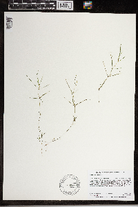 968329[1368910]Millaway, Courtney L. CLM1552018-06-20 United States, Minnesota, Wright, 3 miles northeast of Cokato., 45.11081 -94.1581 |
MIN:Plants | 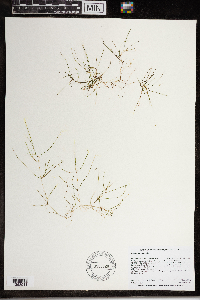 968328[1368911]Millaway, Courtney L. CLM1572018-06-19 United States, Minnesota, Wright, 3 miles southwest of Buffalo., 45.13965 -93.90865 |
MIN:Plants | 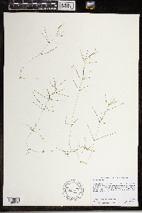 968327[1368912]Millaway, Courtney L. CLM1582018-06-19 United States, Minnesota, Wright, 3 miles southwest of Buffalo., 45.1418 -93.91566 |
MIN:Plants | 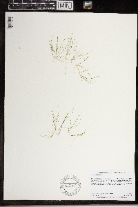 968326[1368913]Millaway, Courtney L. CLM1592018-06-12 United States, Minnesota, Wright, 1 mile northeast of the town of Howard Lake., 45.07665 -94.0639 |
MIN:Plants |  968325[1368914]Millaway, Courtney L. CLM1602018-06-13 United States, Minnesota, Wright, 5 miles southwest of Waverly., 45.02442 -94.0545 |
MIN:Plants |  968324[1368915]Millaway, Courtney L. CLM1612018-06-05 United States, Minnesota, Hennepin, 3 miles southeast of Rockford., 45.06427 -93.67571 |
MIN:Plants |  968323[1368916]Millaway, Courtney L. CLM1622017-09-11 United States, Minnesota, Wright, 0.5 miles north of Annandale., 45.26813 -94.12775 |
MIN:Plants |  968322[1368917]Millaway, Courtney L. CLM1632017-08-15 United States, Minnesota, Pope, 2 miles south of Glenwood., 45.62563 -95.40365 |
MIN:Plants |  968321[1368918]Millaway, Courtney L. CLM1642017-10-04 United States, Minnesota, Kandiyohi, 4.5 miles southwest of Spicer., 45.19009 -95.00678 |
MIN:Plants |  968320[1368919]Millaway, Courtney L. CLM1652017-08-24 United States, Minnesota, Kandiyohi, 12 miles east-southeast of Willmar., 45.07249 -94.81029 |
MIN:Plants |  968319[1368920]Millaway, Courtney L. CLM1662017-08-24 United States, Minnesota, Kandiyohi, 11 miles southeast of Willmar., 44.99662 -94.91113 |
MIN:Plants |  968318[1368921]Millaway, Courtney L. CLM1672017-08-31 United States, Minnesota, Stearns, 4 miles north of Annandale., 45.32178 -94.14713 |
MIN:Plants |  968317[1368922]Millaway, Courtney L. CLM1682017-09-06 United States, Minnesota, Stearns, 13 miles south of Glenwood., 45.46684 -95.35425 |
MIN:Plants |  968316[1368923]Millaway, Courtney L. CLM1692017-08-31 United States, Minnesota, Wright, 2.5 miles northeast of Annandale., 45.27729 -94.0778 |
MIN:Plants |  968373[1368954]Millaway, Courtney L. CLM2132018-06-15 United States, Minnesota, Wright, 3.5 miles southwest of Annandale., 45.21708 -94.15808 |
MIN:Plants |  968365[1368962]Millaway, Courtney L. CLM2252019-07-26 United States, Minnesota, Pope, 1 mile southwest of the town of Villard., 45.70523 -95.28904 |
MIN:Plants |  968364[1368963]Millaway, Courtney L. CLM2262019-07-22 United States, Minnesota, Stearns, 2 miles southwest of Cold Spring., 45.44011 -94.46212 |
MIN:Plants |  968363[1368964]Millaway, Courtney L. CLM2272019-07-23 United States, Minnesota, Stearns, 1.5 miles southwest of Cold Spring., 45.44003 -94.44673 |
MIN:Plants |  968358[1368969]Millaway, Courtney L. CLM2322019-07-16 United States, Minnesota, Stearns, 2.5 miles southwest of Cold Spring., 45.43666 -94.47419 |
MIN:Plants |  968357[1368970]Millaway, Courtney L. CLM2332019-07-15 United States, Minnesota, Stearns, 1.5 miles southeast of Richmond., 45.44078 -94.4941 |
MIN:Plants |  968356[1368971]Millaway, Courtney L. CLM2342019-07-17 United States, Minnesota, Stearns, 2 miles east-southeast of Richmond., 45.44676 -94.47527 |
MIN:Plants |  968353[1368974]Millaway, Courtney L. CLM2372019-07-10 United States, Minnesota, Stearns, 1.5 miles south of Richmond., 45.42923 -94.52099 |
MIN:Plants |  968352[1368975]Millaway, Courtney L. CLM2382019-07-02 United States, Minnesota, Stearns, 4 miles south of Richmond., 45.39253 -94.5211 |
MIN:Plants |  968351[1368976]Millaway, Courtney L. CLM2392019-07-11 United States, Minnesota, Stearns, 1.5 miles southeast of Richmond., 45.44027 -94.49942 |
MIN:Plants |  968346[1368981]Millaway, Courtney L. CLM2442019-08-12 United States, Minnesota, Todd, 2 miles south of Grey Eagle., 45.79511 -94.75068 |
MIN:Plants |  968345[1368982]Millaway, Courtney L. CLM2452019-08-13 United States, Minnesota, Pope, 3 miles south-southwest of Villard., 45.67337 -95.28991 |
MIN:Plants |  975726[1404719]Perleberg, Donna J. DJP2002.0531-012002-05-31 United States, Minnesota, Rice, Cedar Lake (66005200), 44.2959 -93.4305 |
MIN:Plants |  975725[1404718]Brown, Nicole L. s.n.2004-05-27 United States, Minnesota, Meeker, Spring Lake (47003200) SE shore, 45.0914 -94.3017 |
MIN:Plants |  975724[1404717]Perleberg, Donna J. DJP2007.0828-062007-08-28 United States, Minnesota, Pope, Minnewaska Lake (61013000) Starbuck Marina, 45.6073 -95.5246 |
MIN:Plants |  975723[1404716]Perleberg, Donna J. DJP2017.0630-042017-06-30 United States, Minnesota, Lyon, Cottonwood Lake (42001400) swim beach, 44.61338 -95.66933 |
MIN:Plants |  975722[1404715]Perleberg, Donna J. DJP2018.0614-012018-06-14 United States, Minnesota, Lyon, School Grove Lake (42000200) public access on northwest shore off 350th St., 44.55739 -95.92454 |
MIN:Plants |  975721[1404714]Perleberg, Donna J. DJP2018.0628-102018-06-28 United States, Minnesota, Swift, Shible Lake (76014100) public access on southeast shore in State of MN Wildlife Management Area, 45.24921 -96.04392 |
MIN:Plants |  975720[1404713]Perleberg, Donna J. DJP2018.0919-032018-09-19 United States, Minnesota, Clay, Silver Lake (14010000) public boat ramp on northwest shore off Co Rd 32, 46.83228 -96.32645 |
MIN:Plants |  976810[1402419]Perleberg, Donna J. DJP2009.0728-032009-07-28 United States, Minnesota, Kandiyohi, Florida Lake (34021700), 45.2441 -95.064 |
MIN:Plants |  976818[1402427]Perleberg, Donna J. DJP2013.0708-022013-07-08 United States, Minnesota, Isanti, Long Lake (30007200) |
MIN:Plants |  976812[1402421]Perleberg, Donna J. DJP2014.0715-022014-07-15 United States, Minnesota, Waseca, St. Olaf Lake (81000300) east shore, 43.90186 -93.41155 |
MIN:Plants |  976809[1402418]Perleberg, Donna J. DJP2015.0709-082015-07-09 United States, Minnesota, Lincoln, Shaokotan Lake (41008900) |
MIN:Plants |  976819[1402428]Perleberg, Donna J. DJP2017.1017-022017-10-17 United States, Minnesota, Douglas, Geneva Lake (21005200) at public boat ramp, 45.91484 -95.32793 |
MIN:Plants |  976816[1402425]Perleberg, Donna J. DJP2018.0613-042018-06-13 United States, Minnesota, Lincoln, Hendricks Lake (41011000) 500 ft south of boat ramp on northeast shore; at outlet to Lac Qui Parle River, 44.50481 -96.43528 |
MIN:Plants |  976814[1402423]Perleberg, Donna J. DJP2018.0613-062018-06-13 United States, Minnesota, Lincoln, Steep Bank Lake (41008200) 150 ft west of public access on southeast shore, 44.53501 -96.32385 |
MIN:Plants |  976815[1402424]Perleberg, Donna J. DJP2018.0613-072018-06-13 United States, Minnesota, Lincoln, Benton Lake (41004300) public access on southwest shore, 44.26406 -96.28508 |
MIN:Plants |  976813[1402422]Perleberg, Donna J. DJP2018.0614-042018-06-14 United States, Minnesota, Lyon, Lady Slipper Lake (42002000) public access on east shore off 330th Avenue, 44.57204 -95.62099 |
MIN:Plants |  976811[1402420]Perleberg, Donna J. DJP2018.0614-052018-06-14 United States, Minnesota, Yellow Medicin, Wood Lake (87003000) public access on north shore off 557 St., 44.69503 -95.52456 |
Google Map
Google Maps is a web mapping service provided by Google that features a map that users can pan (by dragging the mouse) and zoom (by using the mouse wheel). Collection points are displayed as colored markers that when clicked on, displays the full information for that collection. When multiple species are queried (separated by semi-colons), different colored markers denote each individual species.