University of Minnesota
http://www.umn.edu/
612-625-5000
http://www.umn.edu/
612-625-5000
Minnesota Biodiversity Atlas
Bell Museum
Dataset: MIN-Plants
Taxa: Typhaceae
Search Criteria: excluding cultivated/captive occurrences
Bell Museum plants | |
 MIN:Plants |  Typha NULL 444670[1154484]Moore, John; Tryon, R. 176201945-07-09 United States, Minnesota, Nobles, 5 mi NW of Reading;;;;, 43.754764 -95.783906 |
MIN:Plants |  Typha NULL 835440[1154482;1154483]Myhre, K. 39641993-06-27 United States, Minnesota, Pine, 3 mi N of Mallard Lake. NE1/4 of NE1/4 of section;Saint Croix State Forest;042N;16W;33, 46.074492 -92.378805 |
MIN:Plants |  Typha NULL 229314[1189756]Trask, B. 37 United States, California |
MIN:Plants |  Typha x glauca Godron 906960[1154616]Smith, Welby 311082008-08-13 United States, Minnesota, Le Sueur, About 4 miles northwest of Waterville. SE1/4 of SW1/4 of section;Murphy Wildlife Management Area [Le Sueur County];109N;23W;05, 44.2713889 -93.6197222 |
MIN:Plants |  Typha x glauca Godron 456212[1154614]Bissonnette, K.; Dorn, K. KB10022006-10-08 United States, Minnesota, Ramsey, Falcon Heights Community Park (Cleveland Ave & Roselawn St.) Ramsey County;;;;, 44.998 -93.1868333, 303m |
MIN:Plants |  Typha x glauca Godron 338382[1154601]Breckenridge, Walter s.n.1937-10-23 United States, Minnesota, Ramsey, Birch Lake;;030N;22W;, 45.085264 -93.03805 |
MIN:Plants |  Typha x glauca Godron 459446[1154602]Myhre, K. 42381993-07-22 United States, Minnesota, Pine, Located 1 mi NW of Cedar Lake. Plants occur in the road ditch by Cedar Creek. SE1/4 of NE1/4 of section;;040N;20W;30, 45.924724 -92.872271 |
MIN:Plants |  Typha x glauca Godron 508682[1154603]Lee, Michael MDL10281995-06-20 United States, Minnesota, Wabasha, ridgetop along Hwy 60 E of Zumbro Falls 2 1/4 mi. SWSE of section;Dorer Memorial Hardwood State Forest;110N;13W;33, 44.2833 -92.422126 |
MIN:Plants |  Typha x glauca Godron 516004[1154615]Smith, Welby 181751990-08-29 United States, Minnesota, Dodge, About 2.5 mi W-SW of Mantorville. SW1/4 of SE1/4 of section;Pheasants Forever Wildlife Management Area;107N;17W;24, 44.0530548 -92.9300003 |
MIN:Plants |  Typha x glauca Godron 542534[1154612]Moore, John 213411951-08-09 United States, Minnesota, Grant, 3/4 mi NE of Elbow Lake;;;;, 46.015062 -95.995729 |
MIN:Plants |  Typha x glauca Godron 696496[1154609]Smith, Welby 6791978-07-19 United States, Minnesota, Wright, 1/4 mi W of state aid road 6. NE1/4 of secton;;121N;27W;28, 45.264522 -94.082048 |
MIN:Plants |  Typha x glauca Godron 730440[1154599]Cross-Cella, J. 3461980-08-12 United States, Minnesota, Wilkin, 8 mi N of Rothsay. NE1/4 SE1/4 of section;Western Prairie North, The Nature Conservancy;136N;45W;17, 46.59078 -96.280619 |
MIN:Plants |  Typha x glauca Godron 735619[1154626;1154627]Benson, Douglas 3691981-08-06 United States, Minnesota, Wilkin, Foxhome Prairie. E edge of preserve. NE1/4 NE1/4 S.24. T133N R45W. [Foxhome Prairie, The Nature Conservancy], 46.318653 -96.290714 |
MIN:Plants |  Typha x glauca Godron 735880[1154617;1154618]Benson, Douglas 4541981-09-01 United States, Minnesota, Wilkin, Along W border of preserve. SW1/4 NW1/4 of section;Kettledrummer Prairie, The Nature Conservancy;T133N R45W S12, 46.347907 -96.290981 |
MIN:Plants |  Typha x glauca Godron 749563[1154610]Bonnewell, V.; et al. s.n.1978-07-22 United States, Minnesota, Beltrami, Waskish. NE1/4 of section;Red Lake State Forest;154N;30W;08, 48.1717 -94.509235 |
MIN:Plants |  Typha x glauca Godron 840294[1154595]Myhre, K. 42841993-08-03 United States, Minnesota, Pine, West of Oak Lake. NE1/4 of SW1/4 of section;;045N;18W;15, 46.387289 -92.594817 |
MIN:Plants |  Typha x glauca Godron 551685[1154600]Tusler, W. s.n.1958-00-00 United States, Minnesota, Hennepin, Priest's Bay, W end of Lake Minnetonka;;;;, 44.919734 -93.677354 |
MIN:Plants |  Typha x glauca Godron 386084[1154598]Moyle, J. 40001945-08-01 United States, Minnesota, Freeborn, Albert Lea L, S shore;;N;;, 43.610738 -93.306811 |
MIN:Plants |  Typha x glauca Godron 429986[1154588]Husveth, J. 95-3061995-08-21 United States, Minnesota, Ramsey, NW1/4 of the NW1/4 of S2;;030N;23W;02, 45.121575 -93.143942 |
MIN:Plants |  Typha x glauca Godron 430072[1154589]Lehtinen, R. 95-24001995-09-08 United States, Minnesota, Yellow Medicine, SW1/4 of the NE1/4 of section [collector provided incorrect Range value];Sioux Nationalion Wildlife Management Area;114N;46W;17, 44.683815 -96.4272 |
MIN:Plants |  Typha x glauca Godron 454215[1154605]Kaul, R. 65491989-07-03 United States, Minnesota, Hubbard, small lake, west side of Minn. 200, ca 1 km N of the east entrance to Itasca park.;Itasca State Park;143N;35W;, 47.19592 -95.107697 |
MIN:Plants |  Typha x glauca Godron 475621[1154590]Lehtinen, R. 95-18031995-08-21 United States, Minnesota, Lyon, NE1/4 of the NW1/4 of section;Lyons Wildlife Management Area;110N;42W;34, 44.290277 -95.886639 |
MIN:Plants |  Typha x glauca Godron 475636[1154585]Lehtinen, R. 95-27091995-08-26 United States, Minnesota, Jackson, SE1/4 of the NW1/4 of section;;104N;34W;15, 43.638066 -95.023697 |
MIN:Plants |  Typha x glauca Godron 475751[1154619]Smith, Welby 206401992-06-30 United States, Minnesota, Rice, On the east side of Caron Lake, about 8 miles west of Faribault. SE1/4 of NE1/4 of section;;110N;22W;28, 44.3030548 -93.4683304 |
MIN:Plants |  Typha x glauca Godron 560813[1154621]Ownbey, Gerald; Ownbey, Findley 22701955-07-11 United States, Minnesota, Norman, 10.4 mi W and 1.6 mi S of Mahnomen;;;;, 47.291864 -96.190707 |
MIN:Plants |  Typha x glauca Godron 560898[1154613]Ownbey, Gerald; Anderson, Henry 28241959-07-12 United States, Minnesota, Clearwater, SW shore of Lower Red Lake. SE1/4 of section;Red Lake Indian Reservation;151N;36W;22, 47.881016 -95.249516 |
MIN:Plants |  Typha x glauca Godron 568967[1154586]Moore, John; et al. 251511960-07-14 United States, Minnesota, Anoka, Across the road, north shore of Fish Lake;Cedar Creek National History Area;034N;23W;26, 45.411844 -93.168902 |
MIN:Plants |  Typha x glauca Godron 730093[1154596;1154597]Cutler, S. 1881980-07-25 United States, Minnesota, Chisago, 7 miles west-southwest of Rush City. E1/2 SW1/4 of section;Rush Lake Island Scientific Natural Area;037N;22W;21, 45.674496 -93.095066 |
MIN:Plants |  Typha x glauca Godron 749558[1154620]Bonnewell, V.; Glass, A. s.n.1978-08-04 United States, Minnesota, Cottonwood, NW1/4 of section;Talcot Lake Wildlife Management Area;105N;38W;17, 43.902015 -95.435851 |
MIN:Plants |  Typha x glauca Godron 749562[1154622]Bonnewell, V.; et al. s.n.1978-07-19 United States, Minnesota, Anoka, [no further data];Carlos Avery Wildlife Management Area;032N;22W;19, 45.247476 -93.131875 |
MIN:Plants |  Typha x glauca Godron 749564[1154623]Bonnewell, V.; et al. s.n.1978-07-21 United States, Minnesota, Roseau, SW1/4 of section;Roseau River Wildlife Management Area;T163N R42W S01, 48.919535 -96.032351 |
MIN:Plants |  Typha x glauca Godron 749565[1154624]Bonnewell, V.; Glass, A. s.n.1978-08-03 United States, Minnesota, Big Stone, NE1/4 of secton;Lac Qui Parle Wildlife Management Area;120N;44W;07, 45.221809 -96.202323 |
MIN:Plants |  Typha x glauca Godron 749566[1154625]Bonnewell, V.; et al. s.n.1978-07-26 United States, Minnesota, Sherburne, SE1/4 of section;Sherburne National Wildlife Refuge;T032N R27W S07, 45.490813 -93.721671 |
MIN:Plants |  Typha x glauca Godron 749569[1154607]Bonnewell, V.; et al. s.n.1978-07-20 United States, Minnesota, Becker, Along dike road across Tamarac Lake. SE1/4 of section;Tamarac National Wildlife Refuge;140N;40W;25, 46.909179 -95.668869 |
MIN:Plants |  Typha x glauca Godron 749572[1154608]Bonnewell, V.; et al. s.n.1978-07-21 United States, Minnesota, Marshall, Mud River Pool;Agassiz National Wildlife Refuge;156N;41W;, 48.351836 -95.933132 |
MIN:Plants |  Typha x glauca Godron 898983[1154593]Smith, Welby 257241995-07-09 United States, Minnesota, Isanti, At Mud Lake. NW1/4 of NE1/4 of section;Crooked Road Wildlife Management Area;035N;25W;33, 45.485 -93.4575 |
MIN:Plants |  Typha x glauca Godron 477775[1154604]Smith, Welby 171131990-06-28 United States, Minnesota, Waseca, At the north end of Buffalo Lake, about 3 miles south of Janesville. NE1/4 of NE1/4 of section;;107N;24W;20, 44.065834 -93.7300034 |
MIN:Plants |  Typha x glauca Godron 438080[1154628]Juhnke, C. 308 CMJ FRO2000-09-29 United States, Minnesota, Goodhue, In Pleasant Valley Lakelet just off north shore toward the west. SW SW SW of section;Frontenac State Park;112N;13W;11, 44.513528 -92.348349 |
MIN:Plants |  Typha x glauca Godron 913777[1154606]Smith, Welby 229881993-07-20 United States, Minnesota, Sibley, At the southeast end of Silver Lake, about 5 miles east of Arlington... NW1/4 of NW1/4 of section;;113N;26W;09, 44.6130556 -93.9686111 |
MIN:Plants |  Typha x glauca Godron 914208[1154611]Smith, Welby 228951993-07-14 United States, Minnesota, Sibley, On the north side of Indian Lake, about 4 miles west of Gaylord. NW1/4 of SW1/4 of section;;113N;29W;21, 44.5791667 -94.3341667 |
MIN:Plants |  Typha x glauca Godron 925094[1154592]Cholewa, A. 28392011-08-26 United States, Minnesota, Anoka, City of Blaine, just west of Anoka County Airport, Goodhue St NE at 93rd Lane NE.;;031N;23W;32, 45.1408333 -93.2261111 |
MIN:Plants |  Typha x glauca Godron 925095[1154591]Cholewa, A. 28382011-08-26 United States, Minnesota, Ramsey, Falcon Heights Community Park, corner of Roselawn and Cleveland avenues. West side of park just north of open-water pond.;;029N;23W;16, 44.9975 -93.1866667 |
MIN:Plants |  Typha x glauca Godron 924692[1154587]Cholewa, A. 28222011-07-08 United States, Minnesota, Anoka, Linwood Lake, boat launch.;Martin-Island-Linwood Lakes County Park;033N;22W;09, 45.3575 -93.0972222 |
MIN:Plants |  Typha x glauca Godron 479441[1154630]Gernes, Mark 0032012-06-26 United States, Minnesota, Lincoln, Just west of Township Rd 243; approx. 8.3 km NE of Tyler. UTM: 14N, 732488, 4913930;Coon Creek Wildlife Area;;;, 44.341335 -96.0834658 |
MIN:Plants |  Typha x glauca Godron 481036[1154629]Gernes, Mark 0022012-07-02 United States, Minnesota, Steele, Approx. 7.5 km NE of Ellendale. Approx. 1733 m E of County Road 45 and 224 m N of SE 138th Street. UTM: 15N, 483562, 4860109;;;;, 43.8939 -93.2046644 |
MIN:Plants |  Typha x glauca Godron 942089[1189753]Smith, Welby R. 319352010-07-29 United States, Minnesota, Koochiching, Small roadside marsh about 2 miles west of Gemmell. NE of SE of section;;152N;28W;24, 47.9666664 -94.1705556 |
MIN:Plants |  Typha x glauca Godron 388244[1189851]Fassett, N. C. s.n. United States, Wisconsin, Dane |
MIN:Plants |  Typha x glauca Godron 364788[1189852]Hayden, A. 9324 United States, Iowa, Clay |
MIN:Plants |  Typha x glauca Godron 364663[1189853]Hayden, A. 9324 United States, Iowa, Clay |
MIN:Plants |  Typha x glauca Godron 605516[1189854]Boivin, B. 12946 Canada, Manitoba, Provencher |
MIN:Plants |  Typha x glauca Godron 388245[1189855]Fassett, N. C. s.n. United States, Wisconsin, Dane |
MIN:Plants |  Typha x glauca Godron 424426[1189856]Hayden, A. 8606 United States, Iowa, Clay |
MIN:Plants |  Typha x glauca Godron 714450[1189857]Ahles, H. E. 86963 United States, Massachusetts, Hampshire |
MIN:Plants |  Typha x glauca Godron 944917[1283080]Nee, M. 613912014-07-30 United States, Wisconsin, Richland, Richland Center, southeastern part along Hwy. 14, between businesses. T10N; R1E; SW1/4 NE1/4 sect. 27, 43.317222 -90.359444 |
MIN:Plants |  Typha x glauca Godron 953233[1291737]Gernes, Mark C. s.n.2016-08-10 United States, Minnesota, Kittson, Skull Lake Wildlife Management Area. MPCA wetland monitoring site 11KITT068, 48.936346 -96.697513 |
MIN:Plants |  Typha x glauca Godron 953232[1291736]Gernes, Mark C. s.n.2016-06-21 United States, Minnesota, Douglas, Less than 1 mile south of Quam Lake. MPCA wetland monitoring stie 11DOUG140, 45.876624 -95.654936 |
MIN:Plants |  Typha x glauca Godron 953231[1291735]Knight, Mary s.n.2016-06-22 United States, Minnesota, Hennepin, Edina, Braemar Golf Course, MPCA wetland monitoring site 11HENN178, 44.871059 -93.387739 |
MIN:Plants |  Typha x glauca Godron 955935[1295490]Gernes, Mark C. s.n.2017-07-24 United States, Minnesota, Douglas, Approx. 2 miles E of Nelson. MPCA wetland monitoring site 17DOUG141, 45.89249715 -95.22028116 |
MIN:Plants |  Typha x glauca Godron 955933[1295491]Gernes, Mark C. s.n.2017-06-26 United States, Minnesota, Polk, Approx. 5 miles S of McIntosh. MPCA wetland monitoring site 17POLK260, 47.56081123 -95.89912425 |
MIN:Plants |  Typha x glauca Godron 955932[1295486]Bourdaghs, Michael s.n.2017-06-26 United States, Minnesota, Swift, Approx. 4 miles NE of Benson, Bench Wildlife Managemetn Area. MPCA wetland monitoring site 08SWIF186, 45.33357423 -95.5200336 |
MIN:Plants |  Typha x glauca Godron 966673[1359348]Whitfeld, T.J.S., Weiblen, G.D., Yang, Y., & Lee, A.K. 2800a2021-06-28 United States, Minnesota, Crow Wing, Cross Lake Recreation Area; Big Trout Lake; shoreline, 46.723222 -94.130089 |
MIN:Plants | Typha x glauca Godron []Timothy J. S. Whitfeld 33672022-07-07 United States, Minnesota, Yellow medicine, Mounds Spring Prairie Scientific and Natural Area, 8.75 miles northwest of Canby, 44.76874 -96.444074, 515m |
MIN:Plants | Typha x glauca Godron []Timothy J. S. Whitfeld 36532023-07-07 United States, Minnesota, Marshall, New Maine Wildlife Management Area, 0.3 miles north northeast of intersection of 390th St NW and Center Ave N., 48.4464 -96.2803, 341m |
MIN:Plants |  912363[1154571]Smith, Welby 230191993-07-21 United States, Minnesota, Meeker, At the north end of Little Swan Lake, about 3 miles north of Dassel. SW1/4 of NW1/4 of section;;119N;29W;11, 45.1344444 -94.2919444 |
MIN:Plants |  919792[1154520]Smith, Welby 258191995-08-01 United States, Minnesota, Pope, Glacial Lakes State Park. Pope County...Glacial Lakes State Park, about 5 miles south of Starbuck...west east of Signalness Lake...T124N R39W NE1/4 of NE1/4 of Sec 23. 124N 39W 23, 45.5394444 -95.5222222 |
MIN:Plants |  905590[1154514]Gerdes, Lynden 45642002-07-10 United States, Minnesota, Lake, Superior National Forest. T56N R09W S19NENW. Lake County...Approx. 21.25 miles ENE of Two Harbors, MN and 0.17 mile NW of Water Tank Lake. Small, dug out pond just north off FR 107.. 056N 09W 19, 47.325945 -91.52614 |
MIN:Plants | 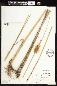 454448[1154490]Miklovic, Stefanie s.n.2001-09-10 United States, Minnesota, Hennepin, Hopkins. Northwest cloverleaf of I-394 and I-94;;117N;22W;03, 44.927638 -93.40162 |
MIN:Plants | 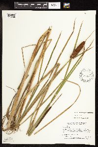 454336[1154569]Myhre, K. 71291997-08-08 United States, Minnesota, Kanabec, Pomroy Lake. Located 10 miles northeast of the town of Mora. Plants occur along the southeast bay of the lake. NW1/4 of NW1/4 of section;;T041N R22W S30, 46.003483 -93.170462 |
MIN:Plants | 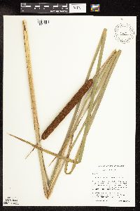 460010[1154521]Lehtinen, R. 95-9051995-08-15 United States, Minnesota, Pope, Pope Co, T124N R38W NE1/4 of the NW1/4 of S28; Nelson Lake;;124N;38W;28, 45.4667 -95.2833 |
MIN:Plants | 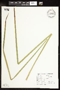 456054[1154559]DeMink, L. 3611999-08-20 United States, Minnesota, Morrison, Crane Meadows National Wildlife Refuge; NENE 30-T40N-R31W;Crane Meadows National Wildlife Refuge;040N;31W;30, 45.933896 -94.251565 |
MIN:Plants |  280957[1189752]Harris, J. Arthur C293241929-07-31 United States, Utah, Washington, near base of Great White Throne;Zion National Park |
MIN:Plants |  120028[1154573]Smith, Welby 175071990-07-29 United States, Minnesota, Steele, Rice Lake State Park. Steele Co.; On the north side of Rice Lake, in Rice Lake State Park. About 7 miles east of Owatonna; Steele Co.; On the north side of Rice Lake, in Rice Lake State Park. About 7 miles east of Owatonna; T 107N R 19W NW1/4 of SW1/4 of SEc 12. 107N 19W 12, 44.085556 -93.0655518 |
MIN:Plants |  347559[1154493]Moyle, J. 31921938-08-19 United States, Minnesota, Kandiyohi, Lake Calhoun.;;;;, 45.273154 -94.832425 |
MIN:Plants |  347704[1154570]Moyle, J. 31431938-07-14 United States, Minnesota, Murray, Vahlialla Bay, Lake Shetek;;;;, 44.124433 -95.693123 |
MIN:Plants |  347799[1154544]Moyle, J. 29381937-08-19 United States, Minnesota, Martin, School Section Lake near Fairmont;;;;, 43.652178 -94.461083 |
MIN:Plants |  363264[1154499]Moyle, J. 34251940-08-31 United States, Minnesota, Hubbard, Shallow Lake;;N;;, 46.967769 -94.876132 |
MIN:Plants |  381453[1154498]Moore, John; et al. 154461942-06-20 United States, Minnesota, Dodge, By roadside above river, 1 mi E [W?] of Berne, Concord Twp. Dodge Co.;;108N;17W;, 44.163573 -92.75917 |
MIN:Plants |  391731[1154494]Lakela, Olga 61461945-08-24 United States, Minnesota, Saint Louis, Superior Bay shore of Oatka Beach Addition. Minnesota Point, Duluth.;Minnesota Point;049N;13W;18, 46.7833 -92.1 |
MIN:Plants |  392991[1154515]Lakela, Olga 65251946-07-27 United States, Minnesota, Saint Louis, St. Louis River marsh, New Duluth, Duluth;;N;;, 46.7833 -92.1 |
MIN:Plants |  402892[1154491]Moyle, J. s.n.1947-08-06 United States, Minnesota, Marshall, Thief Lake;;;;, 48.49043 -95.891094 |
MIN:Plants |  415485[1154540]Moyle, J. s.n.1950-08-06 United States, Minnesota, Crow Wing, East Rabbit Lake at Crosby;;;;, 46.530896 -93.938795 |
MIN:Plants |  421174[1154539]Lakela, Olga 111601950-08-08 United States, Minnesota, Saint Louis, On hwy 2, St. Louis, Aitkin Co. border;;N;;, 46.811654 -92.51455 |
MIN:Plants |  422516[1154504]Lakela, Olga 78581948-09-18 United States, Minnesota, Saint Louis, Highway no. 2 N of Floodwood;;;;, 46.92911 -92.919648 |
MIN:Plants |  425910[1154549]Moyle, J. s.n.1951-07-17 United States, Minnesota, Douglas, Blair Pond near Alexandria.;;N;;, 45.88524 -95.377538 |
MIN:Plants |  432976[1154551]Lee, Michael MDL5951994-06-20 United States, Minnesota, Fillmore, Fillmore Co.; Mile south of Highland; T 102N R 9W NW1/4 of SW1/4 of Sec 1;Dorer Memorial Hardwood State Forest;102N;09W;1, 43.664392 -91.867357 |
MIN:Plants |  447124[1154523]Smith, Welby 210261992-07-20 United States, Minnesota, Redwood, Redwood Co.; in the Minnesota River Valley, about 3 miles northeast of Belview; Redwood Co.; in the Minnesota River Valley, about 3 miles northeast of Belview; T 114N R 37W NE1/4 of NW1/4 of sec 27. 114N 37W 27, 44.6563873 -95.2977753 |
MIN:Plants |  460811[1154556]Smith, Welby 15589A1989-07-04 United States, Minnesota, Nobles, About 6 miles south of Worthington. NE1/4 NE1/4 of section;Wachter Wildlife Management Area;101N;40W;26, 43.5280556 -95.6 |
MIN:Plants |  463787[1154563]Smith, Welby 206391992-06-30 United States, Minnesota, Rice, Rice Co.; On the east side of Caron Lake, about 8 miles west of Faribault; T110N R22W SE1/4 of NE1/4 of Sec 28 Rice Co.; On the east side of Caron Lake, about 8 miles west of Faribault; T 110N R 22W SE1/4 of NE1/4 of Sec 28. 110N 22W 28, 44.3030548 -93.4683304 |
MIN:Plants |  464349[1154488]Smith, Michael 3631996-07-15 United States, Minnesota, Koochiching, BBX-M-86. UTM 483278E 5376652N;Voyageurs National Park;;;, 48.5447167 -93.2265556 |
MIN:Plants |  484856[1154519]Schik, K. 95-681995-08-17 United States, Minnesota, Polk, NW1/4 of the NE1/4 of section;Mentor Wildlife Management Area;149N;43W;16, 47.698298 -96.141155 |
MIN:Plants |  520561[1154524]Smith, Welby 131681987-06-26 United States, Minnesota, Washington, Washington County...on the E side of Highway 4, about 1/2 mile NW of Marine on St. Croix...about 150 feet above the floodplain of the St. Croix River...SW1/4 NE1/4 sec.1, T31N R20W. 031N 20W 1, 45.2061111 -92.7797222 |
MIN:Plants |  535107[1154543]Breckenridge, Walter s.n.1956-07-18 United States, Minnesota, Clay, Felton, edge of town; along railroad;;;;, 47.079722 -96.506944 |
MIN:Plants |  535110[1154541]Breckenridge, Walter s.n.1956-06-12 United States, Minnesota, Douglas, Hidden Lake (Easter Lake); N of Alexandria, along N edge of lake;Lake Carlos State Park;129N;37W;, 45.992645 -95.349492 |
MIN:Plants |  541479[1154583]Scharf, J. s.n.1956-07-12 United States, Minnesota, Murray, Lange Marsh, state owned wetland 9 mi N and 1 mi W of Lake Wilson;;N;;, 44.126985 -95.972975 |
MIN:Plants |  549825[1154567]Moore, John; Ownbey, Gerald 222031954-09-20 United States, Minnesota, Lyon, Yankton Lake;;;;, 44.244222 -95.858544 |
MIN:Plants |  552235[1154548]Moyle, J. 41511947-08-06 United States, Minnesota, Marshall, Thief Lake.;;N;;, 48.49043 -95.891094 |
MIN:Plants |  558293[1154581]Moore, John 236381957-09-25 United States, Minnesota, Clay, 1 mi NW of Barnesville;;N;;, 46.662418 -96.434703 |
MIN:Plants |  560919[1154518]Ownbey, Gerald 22311955-06-30 United States, Minnesota, Clearwater, 4.6 mi N and 1.5 mi E of Clearbrook; near crossing of Ruffy Branch.;;;;, 47.758479 -95.398827 |
MIN:Plants |  560936[1154547]Ownbey, Gerald; Anderson, Henry 28221959-07-12 United States, Minnesota, Clearwater, SW shore of Lower Red Lake; SE1/4 Sec. 22 T151N R36W;;151N;36W;22, 47.881016 -95.249516 |
MIN:Plants |  566698[1154507]Moore, John; Heig, V. 241601958-09-11 United States, Minnesota, Kittson, Border of Twin Lake;;N;;, 48.623587 -96.571031 |
Google Map
Google Maps is a web mapping service provided by Google that features a map that users can pan (by dragging the mouse) and zoom (by using the mouse wheel). Collection points are displayed as colored markers that when clicked on, displays the full information for that collection. When multiple species are queried (separated by semi-colons), different colored markers denote each individual species.