University of Minnesota
http://www.umn.edu/
612-625-5000
http://www.umn.edu/
612-625-5000
Minnesota Biodiversity Atlas
Bell Museum
Dataset: JFBM-Fishes
Taxa: Esocidae
Search Criteria: excluding cultivated/captive occurrences
Bell Museum fishes | |
 JFBM:Fishes |  2659[]Meehean, A. 1929-08-29 United States, Wisconsin, Trempealeau, Mississippi River, Franks Bay, near Trempealeau, 44.00306 -91.44367 |
JFBM:Fishes |  12209[]Kenyon, W. 1941-08-20 United States, Minnesota, Cook, tributary to Brule River (likely Mons Creek), near station 2, at Monhausen's Farm, 47.88377 -90.06832 |
JFBM:Fishes |  12354[]Saari, Hugo 1941-07-14 United States, Minnesota, Cook, Temperance River, 47.73228 -90.88045 |
JFBM:Fishes |  13507[]Minnesota Department of Conservation 1941-09-18 United States, Minnesota, St. Louis, Floodwood River |
JFBM:Fishes | 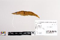 12088[]Nicol; Harden 1941-08-26 United States, Minnesota, St. Louis, St. Louis River |
JFBM:Fishes | 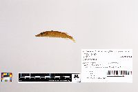 12162[]Kenyon, W.; Saari, Hugo 1941-07-16 United States, Minnesota, Cook, Torgenson Creek at County Road 2, 47.74256 -90.88612 |
JFBM:Fishes | 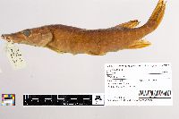 12613[]Minnesota Department of Conservation 1941-09-09 United States, Minnesota, St. Louis, St. Louis River |
JFBM:Fishes | 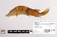 12580[]Minnesota Department of Conservation 1941-08-12 United States, Minnesota, St. Louis, St. Louis River |
JFBM:Fishes |  12550[]Minnesota Department of Conservation 1941-09-09 United States, Minnesota, St. Louis, Pine River |
JFBM:Fishes |  12195[]Minnesota Department of Conservation 1941-07-17 United States, Minnesota, St. Louis, Whiteface River |
JFBM:Fishes |  12512[]Minnesota Department of Conservation 1941-07-12 United States, Minnesota, St. Louis, Cloquet River, 46.96268 -92.32018 |
JFBM:Fishes |  13528[]Minnesota Department of Conservation 1941-07-24 United States, Minnesota, St. Louis, Paleface Creek |
JFBM:Fishes |  13519[]Minnesota Department of Conservation 1941-07-22 United States, Minnesota, St. Louis, Waterhen Creek |
JFBM:Fishes |  13448[]Minnesota Department of Conservation 1941-07-27 United States, Minnesota, St. Louis, Whiteface River |
JFBM:Fishes |  12571[]Minnesota Department of Conservation 1941-06-27 United States, Minnesota, St. Louis, Puck Lake, 6 miles SW of Floodwood, 46.84293 -92.95884 |
JFBM:Fishes |  12396[]Saari, Hugo; Bissinger, L. 1941-09-09 United States, Minnesota, Cook, Swamp River |
JFBM:Fishes | 10775[] 1936-07-03 United States, Minnesota, Cook, Cross River |
JFBM:Fishes |  10773[] 1936-07-10 United States, Minnesota, Cook, Brule River |
JFBM:Fishes |  10774[] 1936-07-22 United States, Minnesota, St. Louis, Comstock Lake, Brimson, 47.22023 -92.22344 |
JFBM:Fishes |  11561[]Moyle, John 1940-07-14 United States, Minnesota, Lake, Gooseberry River, at mouth, 47.14343 -91.46815 |
JFBM:Fishes |  11563[] 1940-08-15 United States, Minnesota, Lake, Ninemile Creek, Station 21, 47.53146 -91.08868 |
JFBM:Fishes |  2929[] 1893-07-03 United States, Minnesota, Crow Wing River |
JFBM:Fishes |  10776[] 1936-07-07 United States, Minnesota, Itasca, Big Bear Lake, 47.66955 -93.26817 |
JFBM:Fishes |  21922[]Underhill, James 1974-06-00 United States, Minnesota, Ramsey, Rice Creek, near Interstate 35W bridge, just SE of Mounds View, 45.09455 -93.18947 |
JFBM:Fishes | 21889[]Huver, Charles 1975-05-31 United States, Minnesota, Pine, St. Croix River at head of Rapids Landing, St. Croix State Park, 45.90327 -92.69577 |
JFBM:Fishes |  11562[]Minnesota Department of Conservation 1940-09-11 United States, Minnesota, Lake, Ninemile Creek, Station 21, 47.53146 -91.08868 |
JFBM:Fishes | 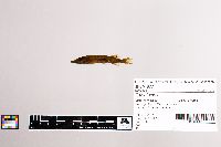 8771[] 1900-00-00 United States, Minnesota, Stearns, Sauk River, Richmond Pond, Richmond, 45.44183 -94.52285 |
JFBM:Fishes | 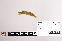 2707[] |
JFBM:Fishes | 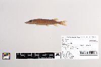 22053[]Underhill, James 1974-10-28 United States, Minnesota, Hubbard, Hennepin Creek, 47.398 -95.09603 |
JFBM:Fishes | 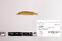 11039[]Nurnberger, P. 1928-07-00 United States, Minnesota, Aitkin, Big Sandy Lake, 46.76052 -93.28721 |
JFBM:Fishes |  2673[]Meehean, A. 1929-10-04 United States, Wisconsin, La Crosse, Pigeon Island near Trempealeau, 43.96712 -91.40007 |
JFBM:Fishes |  2711[] |
JFBM:Fishes |  13874[]Carlander, Kenneth 1940-08-19 United States, Minnesota, Lake of the Woods, Four Mile Bay, Lake of the Woods, 48.84822 -94.76532 |
JFBM:Fishes |  19808[]Eddy, Samuel; Moyle, John 1935-07-03 United States, Minnesota, Cook, Big Saganaga Lake, 48.2265 -90.91942 |
JFBM:Fishes |  23787[]Minnesota Department of Natural Resources 1986-09-11 United States, Minnesota, Winona, Yeomans Pond at Winona, 44.06191 -91.66348 |
JFBM:Fishes |  23901[]Wallmow, Rollo; McCormack, David 1985-08-27 United States, Minnesota, Pope, Outlet Creek, Little Chippewa River, at County Road 81, 3 miles W of Starbuck, 45.60107 -95.59359 |
JFBM:Fishes | 8168[] 1936-07-07 United States, Minnesota, Cass/Itasca, Lake Winnibigoshish, 47.43976 -94.19628 |
JFBM:Fishes | 8122[] 1936-08-13 United States, Minnesota, Itasca, Big Ole Lake, 47.56891 -93.61416 |
JFBM:Fishes | 7779[] 1936-07-31 United States, Minnesota, Itasca, Middle Pigeon Lake, 47.58036 -94.16405 |
JFBM:Fishes | 12645[]Minnesota Department of Conservation 1941-08-26 United States, Minnesota, St. Louis, St. Louis River, SW of Saginaw, 46.80147 -92.48772 |
JFBM:Fishes | 13189[]Minnesota Department of Conservation 1941-08-27 United States, Minnesota, St. Louis, St. Louis River |
JFBM:Fishes | 12626[]Minnesota Department of Conservation 1941-07-08 United States, Minnesota, St. Louis, Whiteface River |
JFBM:Fishes |  13336[]Minnesota Department of Conservation 1941-06-28 United States, Minnesota, St. Louis, Floodwood River |
JFBM:Fishes | 13465[]Minnesota Department of Conservation 1941-07-27 United States, Minnesota, St. Louis, Whiteface River |
JFBM:Fishes | 8112[] 1936-07-09 United States, Minnesota, Cass, Lake Winnibigoshish, Bena District, 47.39974 -94.20982 |
JFBM:Fishes | 1181[JFBM-FISH-0001181] 1936-07-00 Undefined, Undefined, Undefined, unspecified |
JFBM:Fishes | 7828[] 1936-09-01 United States, Minnesota, Cass, Lake Winnibigoshish, Bena District, 47.39974 -94.20982 |
JFBM:Fishes | 13403[]Minnesota Department of Conservation 1941-09-05 United States, Minnesota, St. Louis, Waterhen Creek |
JFBM:Fishes | 13567[]Minnesota Department of Conservation 1941-07-24 United States, Minnesota, St. Louis, Whiteface River |
JFBM:Fishes |  18366[]Eddy, Samuel; Nordlie, Frank 1957-07-16 United States, North Dakota, Traill, Red River of the North, 1 mile W of Hendrum, MN, 47.26688 -96.83487 |
JFBM:Fishes | 7824[] 1936-09-01 United States, Minnesota, Cass, Lake Winnibigoshish, Bena District, 47.39974 -94.20982 |
JFBM:Fishes | 8166[] 1936-07-09 United States, Minnesota, Cass, Lake Winnibigoshish, Bena District, 47.39974 -94.20982 |
JFBM:Fishes | 8147[] 1936-07-09 United States, Minnesota, Cass, Lake Winnibigoshish, Bena District, 47.39974 -94.20982 |
JFBM:Fishes | 8167[] 1936-07-07 United States, Minnesota, Cass/Itasca, Lake Winnibigoshish, 47.43976 -94.19628 |
JFBM:Fishes | 8148[]Eddy, Samuel; Conservation Corps Survey Crew 1936-07-08 United States, Minnesota, Cass, Lake Winnibigoshish, 47.44388 -94.18991 |
JFBM:Fishes | 7788[] 1936-07-07 United States, Minnesota, Cass/Itasca, Lake Winnibigoshish, 47.43976 -94.19628 |
JFBM:Fishes | 7789[] 1936-07-07 United States, Minnesota, Cass/Itasca, Lake Winnibigoshish, 47.43976 -94.19628 |
JFBM:Fishes | 8169[]Eddy, Samuel; Conservation Corps Survey Crew 1936-07-08 United States, Minnesota, Cass, Lake Winnibigoshish, 47.44388 -94.18991 |
JFBM:Fishes | 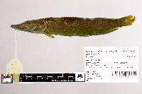 7449[]Nachtrieb, Henry 2000-07-18 United States, Minnesota, Wabasha, Mississippi River, near mouth of Zumbro River, 44.29117 -91.92398 |
JFBM:Fishes | 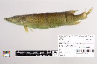 3138[]Olson, T. 1932-06-11 United States, Minnesota, Polk, Red Lake River drainage above Crookston |
JFBM:Fishes | 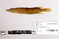 3000[] 1929-09-01 United States, Minnesota, Stearns, Sauk River, Richmond Pond, Richmond, 45.44183 -94.52285 |
JFBM:Fishes | 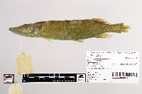 12675[]Carlander, Kenneth 1941-09-00 United States, Minnesota, Lake of the Woods, Lake of the Woods, 49.27497 -94.71863 |
JFBM:Fishes |  22929[]Blackburn, Jamie; McCormack, David 1984-07-03 United States, Minnesota, St. Louis, Berry Creek at County Road 547, 2 miles SE of Brimson, 47.27178 -91.91849 |
JFBM:Fishes |  7418[] 1899-06-09 United States, Minnesota, Scott, Lake 1.5 miles below Hamilton Station (present-day Savage), 44.79207 -93.32989 |
JFBM:Fishes |  2818[] 1928-06-25 United States, Minnesota, Winona, Mississippi River, downstream of Homer, 44.02615 -91.52624 |
JFBM:Fishes | 20447[]Minnesota Department of Conservation 1967-00-00 United States, Minnesota, Washington, St. Croix River, Lake St. Croix at Bayport, 45.01943 -92.76684 |
JFBM:Fishes | 11263[] 1940-09-30 United States, Minnesota, Bass Pond |
JFBM:Fishes | 7407[] 1899-06-27 United States, Minnesota, Scott, Minnesota River, near Shakopee, 44.80047 -93.52558 |
JFBM:Fishes |  7348[] 1899-07-31 United States, Wisconsin, Pierce, near Prescott, 44.74886 -92.80215 |
JFBM:Fishes |  7349[] 1899-07-31 United States, Wisconsin, Pierce, near Prescott, 44.74886 -92.80215 |
JFBM:Fishes |  7350[] 1899-07-31 United States, Wisconsin, Pierce, near Prescott, 44.74886 -92.80215 |
JFBM:Fishes |  7351[] 1899-07-31 United States, Wisconsin, Pierce, near Prescott, 44.74886 -92.80215 |
JFBM:Fishes |  7595[]Meehean, A. 1929-09-25 United States, Wisconsin, La Crosse, Mississippi River, La Moille Island, Lower Gibbs Slough, 43.92294 -91.34874 |
JFBM:Fishes | 24067[] 1941-02-24 United States, Minnesota, Otter Tail, Crystal Lake, 46.61489 -95.95053 |
JFBM:Fishes | 24068[] 1943-04-30 United States, Minnesota, Ramsey, Ike Walton Bass Pond, St. Paul fish hatchery, 44.94418 -93.04763 |
JFBM:Fishes | 8119[] 1936-08-13 United States, Minnesota, Itasca, Big Ole Lake, 47.56891 -93.61416 |
JFBM:Fishes | 8120[] 1936-08-13 United States, Minnesota, Itasca, Big Ole Lake, 47.56891 -93.61416 |
JFBM:Fishes | 8591[] 1936-06-19 United States, Minnesota, Itasca, Dora Lake, 47.74224 -94.04561 |
JFBM:Fishes | 8164[]Conservation Corps Survey Crew 1936-09-23 United States, Minnesota, Cass, Leech Lake, 47.16126 -94.40791 |
JFBM:Fishes | 7717[] 1936-09-23 United States, Minnesota, Cass, Leech Lake, Walker Bay, 47.10218 -94.56388 |
JFBM:Fishes | 8137[] 1936-07-29 United States, Minnesota, Itasca, Bowstring Lake, 47.53719 -93.90505 |
JFBM:Fishes | 7775[] 1936-07-29 United States, Minnesota, Itasca, Bowstring Lake, 47.53719 -93.90505 |
JFBM:Fishes | 10905[]Conservation Corps Survey Crew 1935-07-19 United States, Minnesota, Cook, Sawbill Lake, 47.89297 -90.87618 |
JFBM:Fishes | 6866[]Conservation Corps Survey Crew 1935-07-19 United States, Minnesota, Cook, Sawbill Lake, 47.89297 -90.87618 |
JFBM:Fishes | 6868[]Conservation Corps Survey Crew 1935-07-19 United States, Minnesota, Cook, Sawbill Lake, 47.89297 -90.87618 |
JFBM:Fishes | 6860[] 1935-07-20 United States, Minnesota, Cook, Sawbill Lake, 47.89297 -90.87618 |
JFBM:Fishes | 6862[] 1935-07-20 United States, Minnesota, Cook, Sawbill Lake, 47.89297 -90.87618 |
JFBM:Fishes | 6859[] 1935-07-20 United States, Minnesota, Cook, Sawbill Lake, 47.89297 -90.87618 |
JFBM:Fishes | 6857[] 1935-07-20 United States, Minnesota, Cook, Sawbill Lake, 47.89297 -90.87618 |
JFBM:Fishes | 6858[] 1935-07-20 United States, Minnesota, Cook, Sawbill Lake, 47.89297 -90.87618 |
JFBM:Fishes | 6855[]Conservation Corps Survey Crew 1935-07-19 United States, Minnesota, Cook, Sawbill Lake, 47.89297 -90.87618 |
JFBM:Fishes | 6863[]Conservation Corps Survey Crew 1935-07-19 United States, Minnesota, Cook, Sawbill Lake, 47.89297 -90.87618 |
JFBM:Fishes | 7819[]Eddy, Samuel; Survey Crew 1936-08-11 United States, Minnesota, Itasca, North Star Lake, Marcelle District, 47.55512 -93.66378 |
JFBM:Fishes | 7723[]Hiner, L. 1936-09-15 United States, Minnesota, Cass, Cass Lake, Pike Bay, 47.34718 -94.57359 |
JFBM:Fishes | 7060[]Eddy, Samuel 1935-08-27 United States, Minnesota, Clearwater, Lake Itasca, 47.2163 -95.19722 |
JFBM:Fishes | 8155[] 1936-06-10 United States, Minnesota, Clearwater, Long Lake, 47.27649 -95.29866 |
JFBM:Fishes | 8159[] 1936-06-10 United States, Minnesota, Clearwater, Long Lake, 47.27649 -95.29866 |
JFBM:Fishes | 8160[] 1936-06-10 United States, Minnesota, Clearwater, Long Lake, 47.27649 -95.29866 |
JFBM:Fishes | 8154[] 1936-06-26 United States, Minnesota, Itasca, Bass Lake, Dora Lake District, 47.70714 -93.95992 |
JFBM:Fishes | 8157[] 1936-06-26 United States, Minnesota, Itasca, Bass Lake, Dora Lake District, 47.70714 -93.95992 |
Google Map
Google Maps is a web mapping service provided by Google that features a map that users can pan (by dragging the mouse) and zoom (by using the mouse wheel). Collection points are displayed as colored markers that when clicked on, displays the full information for that collection. When multiple species are queried (separated by semi-colons), different colored markers denote each individual species.