University of Minnesota
http://www.umn.edu/
612-625-5000
http://www.umn.edu/
612-625-5000
Minnesota Biodiversity Atlas
Bell Museum
Dataset: JFBM-Fishes
Taxa: Esocidae
Search Criteria: excluding cultivated/captive occurrences
Bell Museum fishes | |
 JFBM:Fishes |  29287[]Schmidt, Konrad 1997-06-06 United States, Minnesota, Big Stone, Marsh Lake at road culverts, Lac Qui Parle Wildlife Management Area, 45.21433 -96.1956 |
JFBM:Fishes |  33621[]Schmidt, Konrad 1997-06-07 United States, Minnesota, Lac Qui Parle, tributary to Minnesota River, ca. 4 miles NW of Louisburg, Lac Qui Parle Wildlife Management Area, 45.20611 -96.22599 |
JFBM:Fishes |  29317[]Schmidt, Konrad 1997-09-21 United States, Minnesota, Houston, Crooked Creek, 2.5 miles S of Reno, 43.57193 -91.27956 |
JFBM:Fishes |  29324[]Schmidt, Konrad 1997-06-22 United States, Minnesota, Houston, Pickerel Slough at powerlines, Mississippi River, 43.56037 -91.25871 |
JFBM:Fishes | 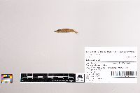 33585[]Schmidt, Konrad 1997-06-06 United States, Minnesota, Lac Qui Parle, Minnesota River, Lac Qui Parle Wildlife Management Area, 45.20321 -96.19629 |
JFBM:Fishes | 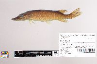 33497[]Schmidt, Konrad 1997-10-07 United States, Minnesota, Roseau, East Branch Warroad River at Cypher's Bridge, State Forest Road, Beltrami Island State Forest, 48.76298 -95.17731 |
JFBM:Fishes | 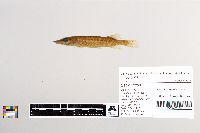 29281[]Schmidt, Konrad 1997-10-08 United States, Minnesota, Lake of the Woods, Roseau River below Roseau Flowage, Red Lake Wildlife Management Area, 48.54571 -95.32064 |
JFBM:Fishes | 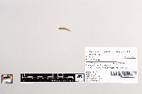 29449[]Schmidt, Konrad 1992-05-26 United States, Minnesota, Mille Lacs, Father Hennepin State Park, Mille Lacs, 46.14844 -93.4861 |
JFBM:Fishes |  29585[]Schmidt, Konrad 1998-06-07 United States, Minnesota, Wadena, Crow Wing River, 2 miles N of Huntersville, 46.80405 -94.88857 |
JFBM:Fishes |  30035[]Schmidt, Konrad 1998-09-15 United States, Minnesota, Cook, Brule River, at mouth, 47.81748 -90.05124 |
JFBM:Fishes |  29834[]Minnesota Pollution Control Agency 1998-08-05 United States, Minnesota, Cook, Swamp River, County-State-Aid-Highway 16 to State Forest Road road heading E, site is downstream of bridge crossing, 10 mi N of Hovland, 47.9889331 -89.9344258 |
JFBM:Fishes |  29528[]Schmidt, Konrad 1998-05-30 United States, Minnesota, Houston, Pine Creek, 1 mile SE of La Crescent, 43.80561 -91.29149 |
JFBM:Fishes |  30379[]Simons, Andrew; Grande, Terry; Bemis, William 1998-07-27 United States, Massachusetts, Hampshire, Oxbow Lake at Oxbow Marina, Northampton, 42.29204 -72.63165 |
JFBM:Fishes | 29842[]Minnesota Pollution Control Agency 1998-08-04 United States, Minnesota, Cook, Brule River, downstream of Forest Road 144, 15 miles N of Grand Marais, 47.96459808 -90.3200256 |
JFBM:Fishes |  29991[]Minnesota Pollution Control Agency 1998-08-04 United States, Minnesota, Cook, Assinika Creek, upstream of Forest Road 141, 8.5 miles NW of Hovland, 47.94433734 -90.20362824 |
JFBM:Fishes |  29582[]Minnesota Pollution Control Agency 1998-07-02 United States, Minnesota, Pine, Pokegama Creek 0.3 miles downstream of County Road 130, 3.5 miles W of Beroun, 45.9170143 -93.02130697 |
JFBM:Fishes |  29589[]Minnesota Pollution Control Agency 1998-08-02 United States, Minnesota, Kanabec, Ann River 0.5 miles upstream of County-State-Aid-Highway 14, 4 miles SW of Mora, 45.84156728 -93.33087821 |
JFBM:Fishes | 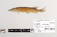 29886[]Minnesota Pollution Control Agency 1998-07-30 United States, Minnesota, Cook, Mistletoe Creek downstream of County-State-Aid-Highway 4, 3.5 miles N of Lutsen, 47.71821423 -90.68941811 |
JFBM:Fishes | 30590[]Minnesota Pollution Control Agency 1999-07-01 United States, Minnesota, Meeker, tributary to North Fork Crow River, ca. 5 miles N of Litchfield, ca. 0.6 mile E of Highway 22, ca. 0.6 mile S of Highway 16, 45.20037003 -94.52968792 |
JFBM:Fishes | 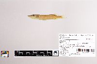 30609[]Minnesota Pollution Control Agency 1999-07-06 United States, Minnesota, Sherburne, Elk River ca. 3.5 miles NW of Big Lake, 0.5 miles E of County Road 73, 45.37845006 -93.76980467 |
JFBM:Fishes | 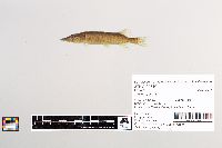 29810[]Minnesota Pollution Control Agency 1998-07-27 United States, Minnesota, Pine, Mission Creek, 1 mile SW of Beroun, 45.8931678 -92.98041125 |
JFBM:Fishes | 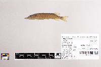 30797[]Schmidt, Konrad 1999-06-18 United States, Minnesota, Dakota, Kennaleys Creek, downstream of railroad tracks in Fort Snelling State Park, 44.493 -93.1302032 |
JFBM:Fishes | 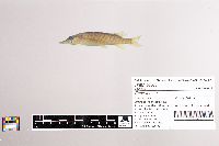 30803[]Schmidt, Konrad 1999-06-26 United States, Minnesota, Dakota, Black Dog Creek, downstream of Nicols Road, in Fort Snelling State Park, 44.82408 -93.2232 |
JFBM:Fishes | 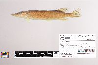 30937[]Schmidt, Konrad 1999-09-28 United States, Minnesota, Anoka, Clearwater Creek at Old Mill Road, in Centerville, 45.1013889 -93.311111 |
JFBM:Fishes | 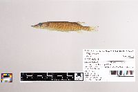 30957[]Schmidt, Konrad 1999-08-06 United States, Minnesota, Hennepin, Elm Creek, upstream of Elm Creek Road in Elm Creek Park Reserve, 45.16301 -93.43666 |
JFBM:Fishes | 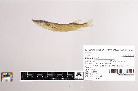 30968[]Schmidt, Konrad 1999-07-16 United States, Minnesota, Hennepin, Rush Creek, group camp in Elm Creek Park Reserve, 45.145 -93.44911 |
JFBM:Fishes | 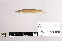 31062[]Schmidt, Konrad 1999-07-02 United States, Minnesota, Carver, Assumption Creek, downstream of US Highway 212, 44.80912 -93.55099 |
JFBM:Fishes | 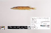 31039[]Schmidt, Konrad 1999-09-25 United States, Minnesota, Ramsey, Tributary to Long Lake, upstream of Old Highway 8, 45.07031 -93.19273 |
JFBM:Fishes | 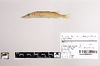 31152[]Schmidt, Konrad 1999-07-03 United States, Minnesota, Crow Wing, Dagget Brook, 1/8 mile upstream of Mitchell Lake at private bridge, 46.78516 -94.0552 |
JFBM:Fishes | 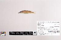 31168[]Minnesota Pollution Control Agency 1999-06-23 United States, Minnesota, Becker, Fish Creek, at County Road 129 and County Road 44, 2.0 miles W of Pine Point, 46.9778155 -95.40982474 |
JFBM:Fishes | 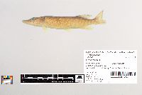 30292[]Schmidt, Konrad 1998-07-17 United States, Minnesota, Dakota, Colonial (Valley) Creek at County Road 45, 44.9038887 -93.1350021 |
JFBM:Fishes | 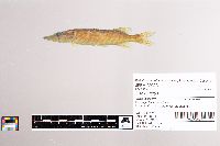 30323[]Schmidt, Konrad 1998-07-25 United States, Minnesota, Hennepin, Minnesota River (old channel), 44.88817 -93.18071 |
JFBM:Fishes | 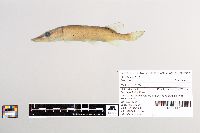 30131[]Schmidt, Konrad 1998-08-19 United States, Minnesota, Lake of the Woods, Poplar Creek, 3 miles WSW of Angle Inlet, Northwest Angle, 49.34123 -95.13439 |
JFBM:Fishes | 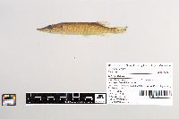 30269[]Schmidt, Konrad 1998-08-25 United States, Minnesota, Martin, East Fork Des Moines River at State Highway 4, 2 miles N of Dunnell, 43.58837 -94.77443 |
JFBM:Fishes | 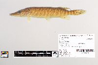 30142[]Schmidt, Konrad 1998-09-30 United States, Minnesota, Lake, Silver Creek at State Highway 61, 47.06439 -91.60521 |
JFBM:Fishes | 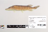 30234[]Schmidt, Konrad 1998-11-01 United States, Minnesota, Houston, Pine Creek, 43.80294 -91.28961 |
JFBM:Fishes | 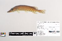 30238[]Schmidt, Konrad 1998-11-09 United States, Minnesota, Houston, Winnebago Creek at State Highway 26, 43.50326 -91.2831 |
JFBM:Fishes | 31241[]Minnesota Pollution Control Agency 1999-06-22 United States, Minnesota, Itasca, Island Lake Creek at County Road 160, ca. 0.2 miles E of County Road 48, ca. 6.0 miles NE of Deer River, 47.41459605 -93.72484453 |
JFBM:Fishes | 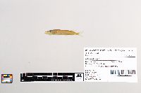 29646[]Mensing, Douglas 1996-07-15 United States, Minnesota, Pine, Fish Lake, near Findlayson, 46.19647 -92.94056 |
JFBM:Fishes | 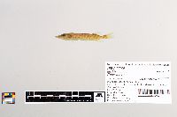 29706[]Mensing, Douglas 1996-06-29 United States, Minnesota, Clearwater, Sucker Creek at Anchor Matson Road, 3 miles W of Lake Itasca, 47.25349 -95.25919 |
JFBM:Fishes | 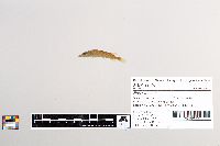 29740[]Lehtinen, Richard 1996-06-28 United States, Minnesota, Hubbard, Shell River, 1 mile SW of Hubbard, 46.82955 -95.03122 |
JFBM:Fishes | 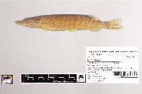 31847[]Schmidt, Konrad 1999-10-25 United States, Minnesota, Houston, Wildcat Creek, downstream of access road to Wildcat Landing, in Brownsville, 43.68923 -91.27351 |
JFBM:Fishes | 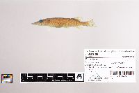 31861[]Schmidt, Konrad; Katula, Ray 1999-11-13 United States, Minnesota, Houston, Pine Creek, 2 miles S of La Crescent and E of Highway 26, 43.80173 -91.30042 |
JFBM:Fishes | 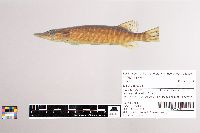 31879[]Schmidt, Konrad; Scharenbroich, C. 1999-10-29 United States, Minnesota, Houston, Crooked Creek, S of Reno and E of Highway 26, 43.5899 -91.27905 |
JFBM:Fishes | 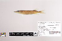 31892[]Schmidt, Konrad 1999-10-25 United States, Minnesota, Houston, Winnebago Creek, N of New Albin and downstream of State Highway 26, 43.5038 -91.28119 |
JFBM:Fishes | 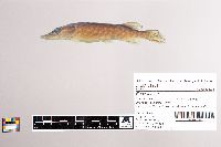 31901[]Schmidt, Konrad 1999-11-30 United States, Minnesota, Winona, Garvin Brook downstream of Minnesota City, 44.09319 -91.74383 |
JFBM:Fishes | 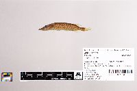 32228[]Schmidt, Konrad 1996-06-21 United States, Minnesota, Morrison, Skunk River, Crane Meadows National Wildlife Refuge, 45.92692 -94.17824 |
JFBM:Fishes | 194[] 1893-07-03 United States, Minnesota, Crow Wing River |
JFBM:Fishes | 6218[]Minty, C. 1934-09-00 United States, Minnesota, Cass, Leech Lake, 47.16126 -94.40791 |
JFBM:Fishes | 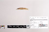 32537[]Minnesota Pollution Control Agency 1999-06-21 United States, Minnesota, Pine, Mission Creek, 1 mile SW of Beroun, 45.8931678 -92.98041125 |
JFBM:Fishes | 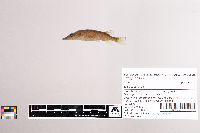 32677[]Minnesota Pollution Control Agency 1999-06-22 United States, Minnesota, Aitkin, Unnamed ditch, ca. 3.0 miles S of Palisade and County Road 3, 1 mile W of County Road 5, 46.67196615 -93.50545004 |
JFBM:Fishes | 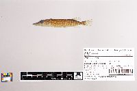 32302[]Minnesota Pollution Control Agency 1999-08-24 United States, Minnesota, Cass, Crow Wing River, 3 miles E of Motley, ca. 1 mile S of Highway 210, ca. 2.7 miles E of Highway 10, 46.32558588 -94.5872132 |
JFBM:Fishes | 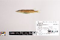 32796[]Minnesota Pollution Control Agency 1999-07-08 United States, Minnesota, Todd, unnamed creek, upstream of County-State-Aid-Highway 38, 4.5 miles W of Long Prairie, 45.99002965 -94.93231674 |
JFBM:Fishes | 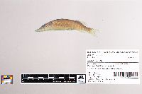 33032[]Hall, Carol; Schmidt, Konrad 1999-07-12 United States, Minnesota, Otter Tail, German Lake, public access, 46.1599998 -95.5124969 |
JFBM:Fishes | 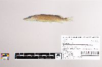 33046[]Hall, Carol; Schmidt, Konrad 1999-07-12 United States, Minnesota, Otter Tail, Pomme De Terre River, downstream of County Road 35, 46.1203003 -95.5419006 |
JFBM:Fishes | 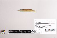 33060[]Hall, Carol; Schmidt, Konrad 1999-07-14 United States, Minnesota, Becker, Floyd Lake, public access, 46.5126991 -95.5121002 |
JFBM:Fishes | 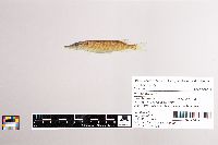 33072[]Hall, Carol; Schmidt, Konrad 1999-07-13 United States, Minnesota, Otter Tail, Long Lake, boat canal at public access, 46.43484 -96.05561 |
JFBM:Fishes |  31307[]Minnesota Pollution Control Agency 1999-10-05 United States, Minnesota, Crow Wing, Pine River, 10 miles NW of Crosby, ca. 3 miles E of Highway 3, ca. 5 miles N of Highway 11, 46.61614861 -94.06803096 |
JFBM:Fishes |  32263[]Minnesota Pollution Control Agency 1999-08-23 United States, Minnesota, Morrison, Platte River ca. 0.1 mile N of County Road 35 (upstream of County Road 35) 1.5 miles NW of Vawter, 45.9266259 -94.25714425 |
JFBM:Fishes |  33183[]Minnesota Pollution Control Agency 1999-07-07 United States, Minnesota, Wright, Twelvemile Creek, ca. 0.1 mile upstream of Highway 12, ca. 3.0 miles E of Howard Lake, 45.06200491 -94.01756166 |
JFBM:Fishes |  33197[]Minnesota Pollution Control Agency 1999-06-16 United States, Minnesota, Chisago, Goose Creek at County-State-Aid-Highway 30, in Harris, 45.58750589 -92.97638393 |
JFBM:Fishes | 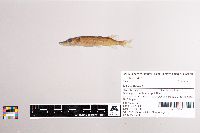 33455[]Minnesota Pollution Control Agency 1999-07-14 United States, Minnesota, Wadena, Farnham Creek at County Road 30, ca 10 miles N of Staples, 46.50702422 -94.79380283 |
JFBM:Fishes | 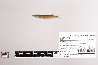 33442[]Minnesota Pollution Control Agency 1999-07-08 United States, Minnesota, Todd, Long Prairie River, ca. 2.25 miles E of Clotho, ca. 0.5 stream miles upstream of Freemans Creek confluence, 46.01272486 -94.99048538 |
JFBM:Fishes | 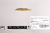 33646[]Minnesota Pollution Control Agency 1999-07-29 United States, Minnesota, Otter Tail, unnamed creek, 3.5 miles SE Deer Creek, ~3.0 mi. E. of Hwy 29, ca. 0.75 mile W of County Road 73, 46.35047214 -95.26266793 |
JFBM:Fishes | 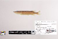 33750[]Minnesota Pollution Control Agency 1999-07-19 United States, Minnesota, Meeker, Grove Creek, upstream ca. 1.0 mi of County Road 16, upstream ca. 0.1 mile of County Road 30, 3.0 miles NE of Grove City, 45.19824367 -94.62781297 |
JFBM:Fishes | 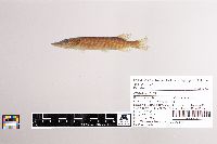 33740[]Minnesota Pollution Control Agency 1999-07-01 United States, Minnesota, Kanabec, Bogus Brook, ca. 4.5 miles S of Highway 23, downstream (N) of County Road 22, 3.0 miles SE of Bock, 45.73815499 -93.51131327 |
JFBM:Fishes | 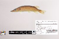 33725[]Minnesota Pollution Control Agency 1999-07-19 United States, Minnesota, McLeod, County Ditch 13, downstream of Garden Avenue, 4 miles N of Glencoe, 44.81226947 -94.14957629 |
JFBM:Fishes | 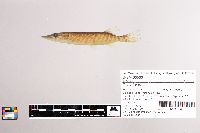 33563[]Minnesota Pollution Control Agency 1999-07-21 United States, Minnesota, Sherburne, Elk River, ca. 3.5 miles NW of Big Lake, 0.5 miles E of County Road 73, 45.37845006 -93.76980467 |
JFBM:Fishes | 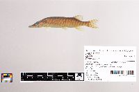 34095[]Stauffer, Jay 1997-07-07 United States, Minnesota, Hennepin, Shingle Creek at Queen Avenue N, Minneapolis, 45.04982 -93.31019 |
JFBM:Fishes | 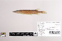 33936[]Lee, Kathy 1997-09-24 United States, Minnesota, Kandiyohi, North Fork Crow River, upstream of Paynesville, 4 miles SE of Regal, 45.37711 -94.77339 |
JFBM:Fishes | 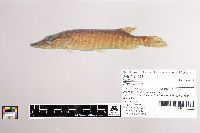 34013[]Stauffer, Jay 1997-09-26 United States, Minnesota, Hennepin, Elm Creek in Elm Creek Park Reserve, near Champlain, 45.1631 -93.43615 |
JFBM:Fishes | 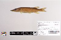 34380[]Schmidt, Konrad 1994-08-30 United States, Minnesota, Hennepin, Elm Creek at Mud Lake outlet, Elm Creek Park Reserve, 45.14125 -93.44198 |
JFBM:Fishes | 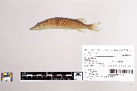 33795[]Minnesota Pollution Control Agency 1999-08-10 United States, Minnesota, Chisago, St. Croix River, E of Rush City at ferry crossing, 45.68198809 -92.8772656 |
JFBM:Fishes | 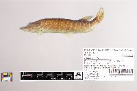 34211[]Minnesota Pollution Control Agency 1999-08-24 United States, Minnesota, Hubbard, Fish Hook River, below dam at Park Rapids DNR, S of Highway 34 and W of Highway 71, 46.91951511 -95.05247331 |
JFBM:Fishes | 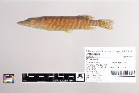 34349[]Stauffer, Jay 1997-09-30 United States, Minnesota, Hennepin, Nine Mile Creek near James Circle in Bloomington, 44.4847222 -93.1808333 |
JFBM:Fishes | 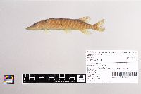 34327[]Lee, Kathy 1997-07-07 United States, Minnesota, Hennepin, Nine Mile Creek near James Circle in Bloomington, 44.4847222 -93.1808333 |
JFBM:Fishes | 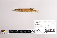 32665[]Minnesota Pollution Control Agency 1999-09-08 United States, Minnesota, Pine, St. Croix River at St. Croix St. Park, 45.95088771 -92.55630601 |
JFBM:Fishes |  34947[]Niemela, Scott 2000-06-27 United States, Minnesota, Stearns, Hobboken Creek S of Highway 28, 45.71507774 -95.00682476 |
JFBM:Fishes |  35074[]Schmidt, Konrad 2000-08-02 United States, Minnesota, Benton, Mayhew Creek, upstream of Highway 23, 5 miles E of Sauk Rapids, 45.58683 -94.05481 |
JFBM:Fishes |  34998[]Minnesota Pollution Control Agency 2000-06-13 United States, Minnesota, Wadena, Crow Wing River at County Road 33 at Cass/Todd/Wadena county line, NW of Motley, 46.38150075 -94.72912449 |
JFBM:Fishes |  36223[]Minnesota Pollution Control Agency 2000-07-05 United States, Minnesota, Mille Lacs, Rum River upstream of County Road 16, 7 miles N of Milaca, 45.86849167 -93.69053218 |
JFBM:Fishes | 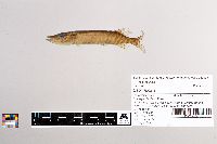 40344[]Niemela, Scott 2001-07-23 United States, Minnesota, Chisago, Rush Creek downstream of County Road 55, across from cemetery, 0.8 miles E of Rush City, 45.6894455 -92.9344482 |
JFBM:Fishes | 8115[] 1936-07-08 United States, Minnesota, Cass, Lake Winnibigoshish, Bena District, 47.39974 -94.20982 |
JFBM:Fishes | 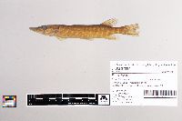 37367[]Schmidt, Konrad 1999-09-28 United States, Minnesota, Anoka, Hardwood Creek at County Road 21, 45.2008324 -93.039444 |
JFBM:Fishes | 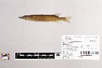 36377[]Schmidt, Konrad; Ley, Jessica 2000-08-23 United States, Minnesota, Todd, Long Prairie River upstream of County Road 62 bridge, 6 miles E of Clarissa, 46.12210624 -94.84326426 |
JFBM:Fishes | 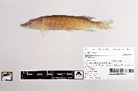 36677[]Feist, Mike 2000-07-19 United States, Minnesota, Itasca, Day Brook upstream of Highway 65, 14 miles N of Nashwauk, 47.56682432 -93.19075272 |
JFBM:Fishes | 36663[]Schmidt, Konrad 2000-09-05 United States, Minnesota, Wadena, Union Creek downstream of 150th Street, downstream of Wadena Treatment Plant, 46.44409225 -95.12494173 |
JFBM:Fishes | 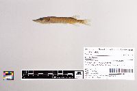 35466[]Minnesota Pollution Control Agency 2000-07-12 United States, Minnesota, Hubbard, Birch Creek at County Road 4, in Yola, 47.23312156 -95.01147862 |
JFBM:Fishes | 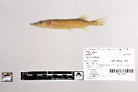 39441[]Talmage, Phil; Niemela, Scott 2001-08-21 United States, Minnesota, Lac Qui Parle, Lac Qui Parle River, 0.75 miles E of County Road 27 in County Park, 44.9980545 -95.9758301 |
JFBM:Fishes | 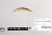 46010[]Schmidt, Konrad; Hall, Carol 2000-07-20 United States, Minnesota, Pine, St. Croix River, from Snake River mouth to 2 miles upstream, 45.84722 -92.74006 |
JFBM:Fishes | 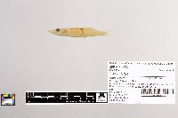 41453[]Bartels, Andy 1991-06-26 United States, Wisconsin, La Crosse, Mississippi River, Pool 8, Upper Goose Island at River Mile 692.7, 4.4 miles NE of Brownsville, 43.7438889 -91.2252808 |
JFBM:Fishes | 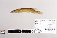 39891[]Schmidt, Konrad 2001-08-27 United States, Minnesota, Faribault, East Branch Blue Earth River upstream of road, 3 miles E of Blue Earth, 43.6274986 -94.0344467 |
JFBM:Fishes | 36612[]Schmidt, Konrad 2000-08-08 United States, Minnesota, Scott, Minnesota River Tributary, downstream of State Highway 13, 44.78464 -93.36491 |
JFBM:Fishes | 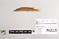 39575[]Feist, Mike 2001-07-16 United States, Minnesota, Swift, Judicial Ditch 8 downstream of County Road 60, 2.5 miles SW of Danvers, 45.2475014 -95.7886124 |
JFBM:Fishes | 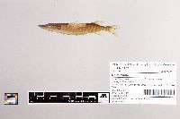 35835[]Minnesota Pollution Control Agency 1997-07-31 United States, Minnesota, Chisago, St. Croix River, downstream of mouth of Sunrise River, 45.56666423 -92.85481311 |
JFBM:Fishes | 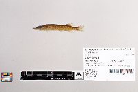 40141[]Feist, Mike 2001-08-09 United States, Minnesota, Chisago, Rush Creek at CSAH 5, 2 mi E of Rush City, 45.6738892 -92.9111099 |
JFBM:Fishes | 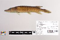 36537[]Feist, Mike 2000-07-06 United States, Minnesota, Crow Wing, Little Pine River, upstream of County Road 36, 7 miles S of Emily, 46.6565071 -93.97946415 |
JFBM:Fishes | 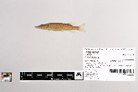 40043[]Niemela, Scott 2001-06-28 United States, Minnesota, Stevens, County Ditch 22 upstream of County Road 54, 15 miles SW of Morris, 45.4447212 -96.144722 |
JFBM:Fishes | 8146[] 1936-07-09 United States, Minnesota, Cass, Lake Winnibigoshish, Bena District, 47.39974 -94.20982 |
JFBM:Fishes | 43334[]Schmidt, Konrad; Talmage, Phil 2001-05-16 United States, Minnesota, Freeborn, Shell Rock River upstream of railroad tracks in Glennville, 43.5769463 -93.2774963 |
Google Map
Google Maps is a web mapping service provided by Google that features a map that users can pan (by dragging the mouse) and zoom (by using the mouse wheel). Collection points are displayed as colored markers that when clicked on, displays the full information for that collection. When multiple species are queried (separated by semi-colons), different colored markers denote each individual species.