University of Minnesota
http://www.umn.edu/
612-625-5000
http://www.umn.edu/
612-625-5000
Minnesota Biodiversity Atlas
Bell Museum
Dataset: All Collections
Taxa: Campylium
Search Criteria: Bell Museum bryophytes; Minnesota; excluding cultivated/captive occurrences
Bell Museum bryophytes | |
 MIN:Bryophytes | 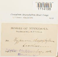 Campylium chrysophyllum (Brid.) Lange 36721[1114198]J.M. Holzinger s.n.1894-08-00 United States, Minnesota, Laneboro |
MIN:Bryophytes | 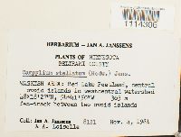 Campylium stellatum (Hedw.) C.E.O. Jensen 748843[1114306]Jan A. Janssens 81211981-11-04 United States, Minnesota, Beltrami, WASKISH AREA: Red Lake Peatland, central ovoid islands in westcentral watershed, 48.3075 -94.697222, 363m |
MIN:Bryophytes | 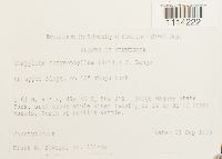 Campylium chrysophyllum (Brid.) Lange 852694[1114222]Frank D. Bowers 23645a1995-09-21 United States, Minnesota, Cook, Judge Magney State Park, area above Brule River (west), ca 24 km NE of Grand Marais, North of Devil's Kettle, 47.766667 -90.033333 |
MIN:Bryophytes | 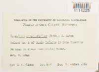 Campylium chrysophyllum (Brid.) Lange 610383[1114225]Olson, W.A. 6991960-08-10 United States, Minnesota, Cook, Island No. 6 of Susie Islands in Lake Superior |
MIN:Bryophytes | 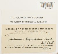 Campylium hispidulum (Brid.) Mitt. 645629[1114259]J.M. Holzinger 2901902-08-15 United States, Minnesota, on Hat Point, a peninsula projecting south-ward from Mt. Josephine, into Lake Superior, near Grand Portage |
MIN:Bryophytes | 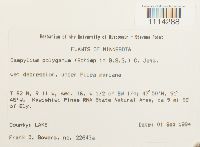 Campylium polygamum (Schimp.) C.E.O. Jensen 853501[1114288]Frank D. Bowers 22643a1994-09-01 United States, Minnesota, Lake, Kawishiwi Pines RNA State Natural Area, ca 9 mi SE of Ely. W 1/2 of SW 1/4, 47.83333 -91.75 |
MIN:Bryophytes | 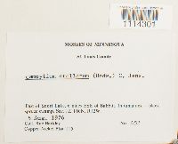 Campylium stellatum (Hedw.) C.E.O. Jensen 753904[1114301]Barkley, Rae 4521976-08-05 United States, Minnesota, Saint Louis, East of Snort Lake, 6 miles ESE of Babbitt, Copper-Nickel Plot T15 |
MIN:Bryophytes | 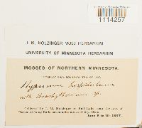 Campylium hispidulum (Brid.) Mitt. 645630[1114257]Holzinger, J.M. s.n.1897-06-08 United States, Minnesota, on Fall Lake, near the foot of Kawasatchong Falls, seven miles north of Ely, Minn. |
MIN:Bryophytes | 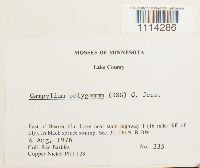 Campylium polygamum (Schimp.) C.E.O. Jensen 753944[1114286]Barkley, Rae 3351976-08-04 United States, Minnesota, Lake, East of Beaver Hut Lake near state highway 1(16 miles SE of Ely). In black spruce swamp, Sec, 31, T61N, R10W. Copper-Nickel Plot T28 |
MIN:Bryophytes | 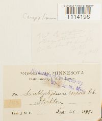 Campylium (Sull.) Mitt. 27472[1114196]J. M. H. 1401889-09-21 United States, Minnesota |
MIN:Bryophytes | 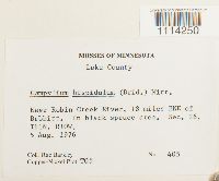 Campylium hispidulum (Brid.) Mitt. 753984[1114250]Barkley, Rae 4051976-08-05 United States, Minnesota, Lake, Near Robin Creek River, 18 miles ENE of Babbitt. Sec. 26, T61N, R10W. Copper-Nickel Plot T05 |
MIN:Bryophytes | 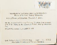 Campylium polygamum (Schimp.) C.E.O. Jensen 809464[1114281]Smith, Welby R. 73751982-08-19 United States, Minnesota, Le Sueur, On the west side of County Highway 23, about 2 miles northeast of St. Peter, in the Minnesota Valley. NE 1/4 NW1/4 section 11, T 110N R 26W |
MIN:Bryophytes | 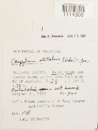 Campylium stellatum (Hedw.) C.E.O. Jensen 749349[1114308]Frank Bowers 5401978-10-21 United States, Minnesota, Beltrami, Water track and spruce woods in Red Lake Peatlands NW of Waskish. S. 25, T 156 N, R32W. |
MIN:Bryophytes |  Campylium hispidulum (Brid.) Mitt. 645631[1114265]J.M. Holzinger 951894-05-00 United States, Minnesota, Winona |
MIN:Bryophytes | 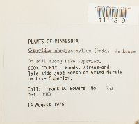 Campylium chrysophyllum (Brid.) Lange 677672[1114219]Frank D. Bowers 7211975-08-14 United States, Minnesota, Cook, along Lake Superior. lake side just north of Grand Marais on Lake Superior. |
MIN:Bryophytes | 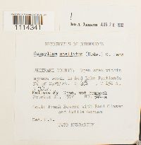 Campylium stellatum (Hedw.) C.E.O. Jensen 749351[1114341]Frank Bowers 544-a1978-10-21 United States, Minnesota, Beltrami, in Red Lake Peatlands NW of Waskish, Relieve #9 |
MIN:Bryophytes | 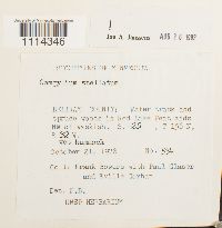 Campylium stellatum (Hedw.) C.E.O. Jensen 749357[1114346]Frank Bowers 531978-10-21 United States, Minnesota, Beltrami, in Red Lake Peatlands NW of Waskish |
MIN:Bryophytes | 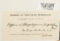 Campylium hispidulum (Brid.) Mitt. 37485[1114262]J.M. Holzinger n.s.1897-06-08 United States, Minnesota, Between Ely and Fall Lake |
MIN:Bryophytes | 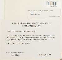 Campylium chrysophyllum (Brid.) Lange 876418[1114210]Gerald A. Wheeler 200261999-06-12 United States, Minnesota, Nicollet, Ca. 2.5 mi. SW of St. Peter on Rte. 169, W of road, SW 1/4 |
MIN:Bryophytes | 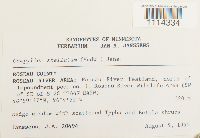 Campylium stellatum (Hedw.) C.E.O. Jensen 812803[1114334]J.A. Janssens 204941990-08-09 United States, Minnesota, Roseau, Roseau River Area: Roseau River Peatlans, north of Impoundment pool no. 1, Roseau River Wildlife Area (SW of SE of S 28 T164N R42W)), 48.993611 -96.080833, 320m |
MIN:Bryophytes | 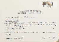 Campylium stellatum (Hedw.) C.E.O. Jensen 812810[1114333]J.A. Janssens 203091990-08-07 United States, Minnesota, Marshall, NEWFOLDEN AREA:, beach-ridge complex 7km SE of East Park Wildlife Management Area, 12km north of New Folden (E_ of SE), 48.44639 -96.28056, 350m |
MIN:Bryophytes |  Campylium chrysophyllum (Brid.) Lange 645212[1114217]J.M. Holzinger s.n.1902-07-26 United States, Minnesota, Cook, along the old Iron Trail, north-west of Grand Marais |
MIN:Bryophytes | 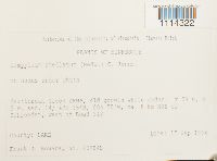 Campylium stellatum (Hedw.) C.E.O. Jensen 852110[1114322]Frank D. Bowers 22984b1994-09-17 United States, Minnesota, Cook, Heartbreak creek cRNA. T 59 N, R 5 W, sec. 14; ca. 8 km NNE of Schroeder, west of Road 343, 47.583333 -90.916667 |
MIN:Bryophytes | 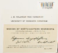 Campylium chrysophyllum (Brid.) Lange 645217[1114206]J.M. Holzinger s.n.1902-07-31 United States, Minnesota, Cook, along Gunflint trail and in a swamp 9 miles north of Grand Marais |
MIN:Bryophytes | 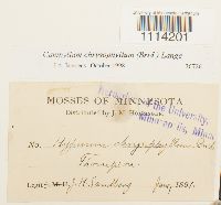 Campylium chrysophyllum (Brid.) Lange 36726[1114201]J.H. Sandberg s.n.1891-06-00 United States, Minnesota, Thompson |
MIN:Bryophytes | 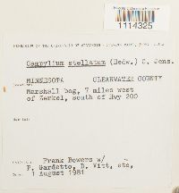 Campylium stellatum (Hedw.) C.E.O. Jensen 734151[1114325]Frank Bowers s.n.1981-08-01 United States, Minnesota, Clearwater, Marshall bog, 7 miles west of Zerkel, south of Hwy 200 |
MIN:Bryophytes | 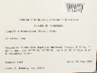 Campylium hispidulum (Brid.) Mitt. 852805[1114273]Frank D. Bowers 224501994-08-30 United States, Minnesota, Lake, Kawishiwi Pines cRNA Superior National Forest, ca 9 km SE of Ely, N of S Kawishiwi River. T62N, R11W, sec. 21 |
MIN:Bryophytes | 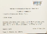 Campylium hispidulum (Brid.) Mitt. 852409[1114274]Frank D. Bowers 23147a1994-09-17 United States, Minnesota, Lake, Wanless Lake white cedar area, 1.2 km SW of Wanless Lake, west on Hwy 2 1.2 km. T60N, R7W, sec. 24 + R6W, sec. 19, ca 15 km NW of Schroeder, 47.616667 -91.166667 |
MIN:Bryophytes | 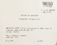 Campylium chrysophyllum (Brid.) Lange 676996[1114208]Frank D. Bowers 6351975-07-31 United States, Minnesota, Beltrami, Swamp 2 miles south of Waskish, west side of Hwy. 72. |
MIN:Bryophytes | 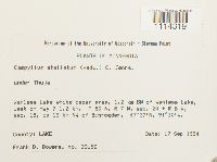 Campylium stellatum (Hedw.) C.E.O. Jensen 852341[1114319]Frank D. Bowers 231561994-09-17 United States, Minnesota, Lake, 1.2 km SW of Wanless Lake, west on Hwy 7 1.2 km. + R 6 W, sec. 19, ca 15 km NW of Schroeder, 47.61667 -91.16667 |
MIN:Bryophytes | 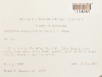 Campylium chrysophyllum (Brid.) Lange 852888[1114241]Frank D. Bowers 236591995-09-21 United States, Minnesota, Cook, Judge Magney State Park, area above Brule River (west), ca 24 km NE of Grand Marais, North of Devil's Kettle, T 61 N, R 4 E, 47.766667 -90.033333 |
MIN:Bryophytes | 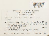 Campylium stellatum (Hedw.) C.E.O. Jensen 809521[1114297]Jan A. Janssens 123961984-06-14 United States, Minnesota, Koochiching, Silverdale Area: Net Lake Spring Fen, 10 km north of Silverdale, 1 km N of Hwy 65. SE NE of Sec. 33 (TRS: T.65N, R22W, Sec. 33), 48.083333 -93.166667, 390m |
MIN:Bryophytes | 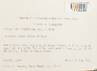 Campylium hispidulum (Brid.) Mitt. 851978[1114246]Frank D. Bowers 223231994-08-29 United States, Minnesota, Lake, Keely Creek RNA, Superior National Forest. TRS: T.61N, R.11W, Sec. 14. Just west of Hwy 1, ca. 17km SE of Ely, S of Keely Creek, 47.633333 -91.7 |
MIN:Bryophytes | 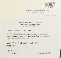 Campylium chrysophyllum (Brid.) Lange 864754[1114234]Gerald A. Wheeler 170521997-08-09 United States, Minnesota, Swift, Ca. 15 mi E of Clontarf, E of Rte. 33. W1/2, NW1/4, NW1/4 of Sec. 8. Kerkhoven 8. |
MIN:Bryophytes | 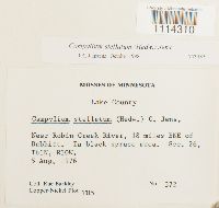 Campylium stellatum (Hedw.) C.E.O. Jensen 753985[1114310]Barkley, Rae 3721976-08-05 United States, Minnesota, Lake, Near Robin Creek River, 18 mi ENE of Babbitt. |
MIN:Bryophytes |  Campylium stellatum (Hedw.) C.E.O. Jensen 610385[1114299]Olson, W.A. 6341960-08-04 United States, Minnesota, Beltrami, At Minn. hwy 72 and north boundary of Red Lake Game Refuge, 48.117115 -94.508822 |
MIN:Bryophytes | 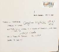 Campylium hispidulum (Brid.) Mitt. 748977[1114248]Frank D. Bowers 79401977-07-29 United States, Minnesota, Beltrami, 5 km south of Waskish, just west of hwy 72 |
MIN:Bryophytes | 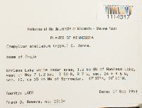 Campylium stellatum (Hedw.) C.E.O. Jensen 852395[1114317]Frank D. Bowers 231341994-09-17 United States, Minnesota, Lake, Wanless Lake white cedar area, 1.2 km SW of Wanless Lake, west on Hwy 7 1.2km. ca 15 km NW of Schroeder. TRS: T.60N, R.7W, Sec. 24 + R.6W, Sec. 19., 47.616667 -91.166667 |
MIN:Bryophytes |  Campylium chrysophyllum (Brid.) Lange 864985[1114233]Gerald A. Wheeler 174061997-08-29 United States, Minnesota, Renville, Ca. 1.5 mi. NE of Morton; S of Rte. 2; Birch Coulee State Memorial Park. NW1/4 NW1/4 (Birch Cooley 28) |
MIN:Bryophytes |  Campylium stellatum (Hedw.) C.E.O. Jensen 812795[1114332]J.A. Janssens 207041990-08-10 United States, Minnesota, Marshall, Middle River Area: beach-ridge Complex, 7.5 km WNW of Thief Lake (SE of SW of Sec.2). TRS: T.158N, R.42W, Sec. 2., 48.5325 -96.028333, 365m |
MIN:Bryophytes | 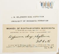 Campylium chrysophyllum (Brid.) Lange 645213[1114216]J.M. Holzinger s.n.1902-08-15 United States, Minnesota, On Hat Point, a peninsula projecting southward from Mt. Josephine, into Lake Superior, near Grand Portage. |
MIN:Bryophytes |  Campylium chrysophyllum (Brid.) Lange 876361[1114211]Gerald A. Wheeler 192191998-06-16 United States, Minnesota, Le Sueur, Ca. 2.7 mi. SW of Kasota; SW of Kasota Prairie SNA. Roadcut along private road. W1/2 SW1/4 S1/4 of Sec. 7 |
MIN:Bryophytes |  Campylium stellatum (Hedw.) C.E.O. Jensen 812884[1114335]J.A. Janssens 193461989-07-21 United States, Minnesota, Becker, OGEMA AREA: Ogema Spring Prairie Fen, southern extension of Spring Creek State Wildlife Management Area, near township border, west of railroad, near intermittent creek, 0.7 NW of Ogema. TRS: T.142N, R.42W, Sec. 13 (NE of SE o Sec. 13 ), 47.11194 -95.93222, 380m |
MIN:Bryophytes | 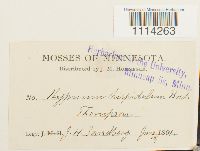 Campylium hispidulum (Brid.) Mitt. 37483[1114263]J.H. Sandberg s.n.1891-06-10 United States, Minnesota, Thompson |
MIN:Bryophytes | 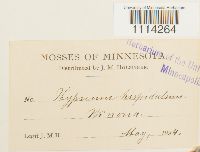 Campylium hispidulum (Brid.) Mitt. 37479[1114264]J.M. Holzinger s.n.1894-05-00 United States, Minnesota, Winona |
MIN:Bryophytes | 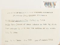 Campylium chrysophyllum (Brid.) Lange 610384[1114218]Olson, W.A. 720b1960-08-17 United States, Minnesota, Cook, Belle Rose Island of Susie Islands in Lake Superior., 47.973776 -89.578978 |
MIN:Bryophytes | 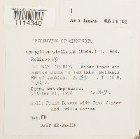 Campylium stellatum (Hedw.) C.E.O. Jensen 749350[1114340]Frank Bowers M-5411978-10-21 United States, Minnesota, Beltrami, Water track and spruce woods in Red Lake Peatlands NW of Waskish |
MIN:Bryophytes | 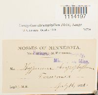 Campylium chrysophyllum (Brid.) Lange 36720[1114197]J.M. Holzinger s.n.1890-07-16 United States, Minnesota, Franconia |
MIN:Bryophytes | 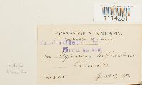 Campylium hispidulum (Brid.) Mitt. 37482[1114251]J.M. Holzinger s.n.1890-06-17 United States, Minnesota, Winona, Lamoille, 44.000269 -91.473139 |
MIN:Bryophytes | 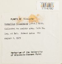 Campylium hispidulum (Brid.) Mitt. 733547[1114280]Quinn, Robert 4621979-08-02 United States, Minnesota, Polk |
MIN:Bryophytes | 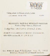 Campylium stellatum (Hedw.) C.E.O. Jensen 809474[1114309]Smith, Welby R. 7141B1982-08-08 United States, Minnesota, Pope, About 8 miles southwest of Brooten. SE 1/4 NW 1/4 |
MIN:Bryophytes | 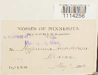 Campylium hispidulum (Brid.) Mitt. 37484[1114256]J.M. H. s.n.1894-05-05 United States, Minnesota, Winona |
MIN:Bryophytes | 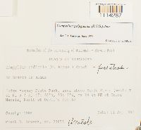 Campylium radicale (P. Beauv.) Grout 852678[1114287]Frank D Bowers 236951995-09-21 United States, Minnesota, Cook, Judge Magney State Park, area above Brule River (west) ca 24 km NE of Grand Marais, North of Devil's Kettle. TRS: T.61N, R.4E., 47.766667 -90.033333 |
MIN:Bryophytes | 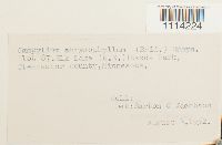 Campylium chrysophyllum (Brid.) Lange 605287[1114224]Jacobson, Burton C. s.n.1952-08-08 United States, Minnesota, Clearwater, Plot 87. Elk Lake (N.E.) Itasca Park |
MIN:Bryophytes | 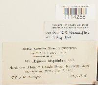 Campylium hispidulum (Brid.) Mitt. 37478[1114258]J.M. Holzinger 1851903-11-07 United States, Minnesota, Straight Slough, Mississippi valley near Winona |
MIN:Bryophytes |  Campylium radicale (P. Beauv.) Grout 481581[1114289]P.J. Rand B421952-05-16 United States, Minnesota, Rice, Nerstrand Woods |
MIN:Bryophytes | 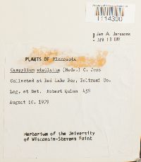 Campylium stellatum (Hedw.) C.E.O. Jensen 733545[1114300]Quinn, Robert 4581979-08-10 United States, Minnesota, Beltrami, at Red Lake Bog |
MIN:Bryophytes | 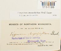 Campylium chrysophyllum (Brid.) Lange 36722[1114199]J.M. Holzinger s.n.1897-06-08 United States, Minnesota, on Fall Lake, near the foot of Kawasatchong Falls, seven miles north of Ely |
MIN:Bryophytes | 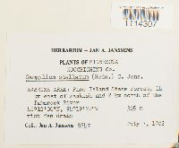 Campylium stellatum (Hedw.) C.E.O. Jensen 748845[1114307]Jan A. Janssens 88471982-07-07 United States, Minnesota, Koochiching, WASKISH AREA: Pine Island State Forest, 14 km east of Waskish and 2 km north of the Tamarack River, 48.2 -94.323333, 365m |
MIN:Bryophytes | 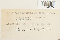 Campylium chrysophyllum (Brid.) Lange 400939[1114223]Eloise Newcomb s.n.1941-08-15 United States, Minnesota, Clearwater, Swamp South of Station, Itasca Park |
MIN:Bryophytes |  Campylium stellatum (Hedw.) C.E.O. Jensen 646120[1114316]J.M. Holzinger s.n.1902-07-16 United States, Minnesota, Cook, In the vicinity of Grand Marais |
MIN:Bryophytes |  Campylium chrysophyllum (Brid.) Lange 864952[1114232]Gerald A. Wheeler 176831997-09-05 United States, Minnesota, Renville, W side of Morton, Morton Outcrop complex. SW1/4, NW1/4, NW1/4 of Sec. 31. (Birch Cooley 31) |
MIN:Bryophytes |  Campylium chrysophyllum (Brid.) Lange 853485[1114235]Frank D Bowers 236461995-09-21 United States, Minnesota, Cook, Judge Magney state Park, area above Brule River (west), ca 24 km NE of Grand Marais, North of Devil's Kettle, 47.766667 -90.033333 |
MIN:Bryophytes | 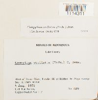 Campylium stellatum (Hedw.) C.E.O. Jensen 753144[1114311]Barkley, Rae 4891976-08-05 United States, Minnesota, Lake, West of Stony River, 8 miles SE of Babbitt. Copper-Nickel Plot T17. |
MIN:Bryophytes | 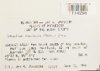 Campylium stellatum (Hedw.) C.E.O. Jensen 809592[1114298]Joannes A Janssens 123251984-06-13 United States, Minnesota, Lake Of The Woods, WARROAD AREA: Mulligan Lake Peatland, 42 km south of Warroad (SE NW of Sec. 25. ), 48.55 -95.25, 380m |
MIN:Bryophytes | 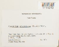 Campylium hispidulum (Brid.) Mitt. 753909[1114249]Barkley, Rae 4471976-08-05 United States, Minnesota, Lake, Near Tony Lake on state highway I (I6 miles SE of Ely). |
MIN:Bryophytes | 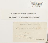 Campylium radicale (P. Beauv.) Grout 645786[1114469]J.M. Holzinger s.n.1890-05-29 United States, Minnesota, Winona |
MIN:Bryophytes | 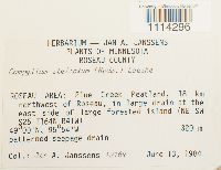 Campylium stellatum (Hedw.) C.E.O. Jensen 809353[1114296]Jan A. Janssens 121691984-06-13 United States, Minnesota, Roseau, Roseau Area: Pine Creek Peatland, 18 km NW of Roseau, at the east side of large forested island (NE SW of Sec. 25). TRS: T.164N, R.41W, Sec. 25., 49 -95.9, 320m |
MIN:Bryophytes | 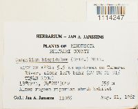 Campylium hispidulum (Brid.) Mitt. 748701[1114247]Jan A. Janssens 110651982-08-21 United States, Minnesota, Beltrami, Waskish Area: 5.9 km upstream on Tamarac River, along left bank (SW SW NE of Sec. 15). TRS: T.154N, R.30W, Sec. 15., 48.15 -94.466667, 359m |
MIN:Bryophytes | 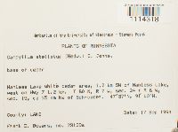 Campylium stellatum (Hedw.) C.E.O. Jensen 852416[1114318]Frank D. Bowers 23129a1994-09-17 United States, Minnesota, Lake, Wanless Lake white cedar area, 1.2 km 5W of Wanless, west of Hwy 7 1.2 km. Ca. 15 km NW of Schroeder. TRS: T.60N, R.7 W, Sec. 24; TRS: T.60N, R.6W, Sec. 19., 47.616667 -91.166667 |
MIN:Bryophytes | 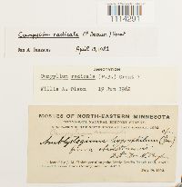 Campylium radicale (P. Beauv.) Grout 639527[1114291]J.M. Holzinger s.n.1902-07-19 United States, Minnesota, Cook, along the Little Devil's Track trail, north of Grand Marais |
MIN:Bryophytes | 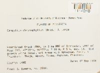 Campylium chrysophyllum (Brid.) Lange 852777[1114240]Frank D. Bowers 230311994-09-17 United States, Minnesota, Lake, Heartbreak creek cRNA. T 59 N, R 5 W, sec. 14; ca. 8 km NNE of Schroeder, west of Road 343, 47.583333 -90.916667 |
MIN:Bryophytes | 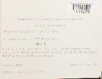 Campylium hispidulum (Brid.) Mitt. 853486[1114275]Frank D Bowers 236451995-09-21 United States, Minnesota, Cook, Judge Magney State Park, area above Brule River (west), ca 24 km NE of Grand Marais, North of Devil's Kettle, 47.766667 -90.033333 |
MIN:Bryophytes |  Campylium chrysophyllum (Brid.) Lange 735373[1114209]Barkley, Rae 3801976-08-05 United States, Minnesota, Lake, Near Robin Creek River, 18 miles ENE of Babbitt |
MIN:Bryophytes | 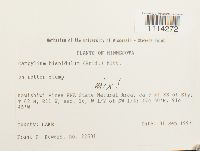 Campylium hispidulum (Brid.) Mitt. 852695[1114272]Frank D. Bowers 226311994-09-01 United States, Minnesota, Lake, Kawashiwi Pines RNA State Natural Area, ca. 9 mi. SE of Ely. W 1/2 of SW 1/4 of Sec. 16. TRS: T.62N, R.11 W, Sec. 16, 47.833333 -91.75 |
MIN:Bryophytes | 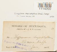 Campylium chrysophyllum (Brid.) Lange 36723[1114200]J.M. H. s.n.1894-06-00 United States, Minnesota, Winona bluffs |
MIN:Bryophytes | 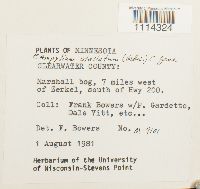 Campylium stellatum (Hedw.) C.E.O. Jensen 734155[1114324]Frank D. Bowers M-91011981-08-01 United States, Minnesota, Clearwater, Marshall bog, 7 miles west of Zerkel, south of Hwy 200 |
MIN:Bryophytes | 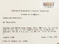 Campylium stellatum (Hedw.) C.E.O. Jensen 852994[1114323]Frank D. Bowers 230821994-09-17 United States, Minnesota, Lake, Wanlass Lake White Cedar Swamp, DNR land, ca. 2.4 km west of cty. Hwy. 7, off logging road. ca. 16 km NW of Schroeder. SW1/4 of Sec. 19., 47.316667 -91.133333 |
MIN:Bryophytes | 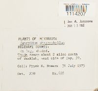 Campylium chrysophyllum (Brid.) Lange 676976[1114207]Frank D. Bowers 6351975-07-31 United States, Minnesota, Beltrami, swamp about 2 miles south of Waskish, west side of Hwy. 72. |
MIN:Bryophytes | 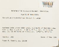 Campylium chrysophyllum (Brid.) Lange 852353[1114236]Frank D. Bowers 231081994-09-17 United States, Minnesota, Lake, Wanless Lake white cedar area, 1.2 km 5W of Wanless, west of Hwy 7 1.2 km. Ca. 15 km NW of Schroeder. TRS: T.60N, R.7 W, Sec. 24; TRS: T.60N, R.6W, Sec. 19., 47.616667 -91.166667 |
MIN:Bryophytes | 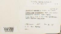 Campylium stellatum (Hedw.) C.E.O. Jensen 747909[1114312]Frank D. Bowers M1291977-08-01 United States, Minnesota, Clearwater, Lake Itasca State Park. Path to Bear Paw campground |
MIN:Bryophytes | 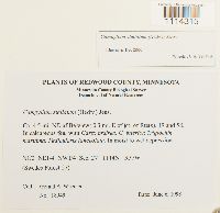 Campylium stellatum (Hedw.) C.E.O. Jensen 876226[1114315]Gerald A. Wheeler 189491998-06-06 United States, Minnesota, Redwood, Ca. 4.5 mi. NE of Belview; 0.3 mi. E of jct. of Rte(s). 19 and 58. N1/2 NE 1/4 NW 1/4 of Sec. 27. |
MIN:Bryophytes | 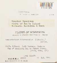 Campylium (Sull.) Mitt. 619790[1114195]Koch, Rudy G. 6586A1969-10-18 United States, Minnesota, Lake, Knife Island; Gull Rookery, Diabase, 46.946324 -91.772956 |
MIN:Bryophytes | 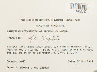 Campylium chrysophyllum (Brid.) Lange 851722[1114202]Frank D. Bowers 23182b1994-09-17 United States, Minnesota, Lake, Wanless Lake white cedar area, 1.2 km SW of Wanless Lake, west on Hwy 7 1.2 KM; ca. 15 km NW of Schroeder., 47.616667 -91.166667 |
MIN:Bryophytes | 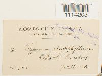 Campylium chrysophyllum (Brid.) Lange 36719[1114203]J.M. H. s.n.1894-06-01 United States, Minnesota, Catholic Cemetery |
MIN:Bryophytes | 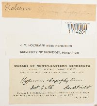 Campylium chrysophyllum (Brid.) Lange 645215[1114204]J.M. Holzinger s.n.1902-07-31 United States, Minnesota, Cook, Along Gunflint trail and in a swamp 9 mi N of Grand Marais |
MIN:Bryophytes | 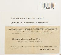 Campylium chrysophyllum (Brid.) Lange 645216[1114205]J.M. Holzinger s.n.1902-07-16 United States, Minnesota, Cook, in the vicinity of Grand Marais |
MIN:Bryophytes | 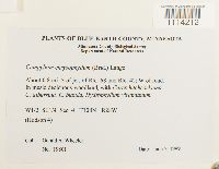 Campylium chrysophyllum (Brid.) Lange 876285[1114212]Gerald A. Wheeler 198011999-06-02 United States, Minnesota, Blue Earth, About 0.8 mi. S of jet. of Rte. 68 and Rte. 42; W of road. W 1/2 SE 1/4 of Sec. 4 |
MIN:Bryophytes | 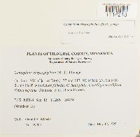 Campylium chrysophyllum (Brid.) Lange 876268[1114213]Gerald A. Wheeler 197041999-05-17 United States, Minnesota, Traverse, Ca. 3 mi. SW of ject. of Rte(s) 27 and 117, SE of Rte 27. E1/2 NE1/4 of Sec. 13 |
MIN:Bryophytes | 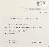 Campylium chrysophyllum (Brid.) Lange 876231[1114214]Gerald A. Wheeler 192891998-06-17 United States, Minnesota, Scott, Ca. 1 mi. NW of Jordan. W1/2 SE1/4 of Sec. 12. (St. Lawrence 12) |
MIN:Bryophytes | 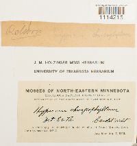 Campylium chrysophyllum (Brid.) Lange 645214[1114215]J.M. Holzinger s.n.1902-07-16 United States, Minnesota, Cook, In the vicinity of Grand Marais |
MIN:Bryophytes | 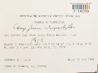 Campylium chrysophyllum (Brid.) Lange 852708[1114220]Frank D. Bowers 24093a1994-08-31 United States, Minnesota, Saint Louis, North of Burntside Lake, ca. 9 km NW of Ely, 47.966667 -91.966667 |
MIN:Bryophytes | 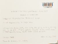 Campylium chrysophyllum (Brid.) Lange 852701[1114221]Frank D. Bowers 24034a1994-09-02 United States, Minnesota, Lake, Tettegouche State Park, 7 acre upland "Island" along north shore of Tettegouche Lake, white cedar north of that., 47.316667 -91.266667 |
MIN:Bryophytes | 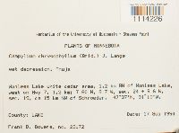 Campylium chrysophyllum (Brid.) Lange 853319[1114226]Frank D Bowers 231721994-09-17 United States, Minnesota, Lake, Wanless Lake white cedar area, 1.2 km SW of Wanless, west on Hwy 7, 1.2 km; ca. 15 km NW of Schroeder, 47.616667 -91.166667 |
MIN:Bryophytes |  Campylium chrysophyllum (Brid.) Lange 852666[1114227]Frank D. Bowers 24178b1995-09-21 United States, Minnesota, Cook, Judge Magney State Park, area about Brule River (west), ca 24 km NE of Grand Marais, North of Devil's Kettle (T61N, R4E), 47.766667 -90.033333 |
MIN:Bryophytes |  Campylium chrysophyllum (Brid.) Lange 852668[1114228]Frank D Bowers 241801995-09-21 United States, Minnesota, Cook, Judge Magney State Park, area above Brule River (west); ca 24 km NE of Grand Marais, North of Devil's Kettle, 47.766667 -90.033333 |
MIN:Bryophytes | 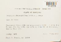 Campylium chrysophyllum (Brid.) Lange 852206[1114229]Frank D Bowers 230381994-09-17 United States, Minnesota, Cook, Heartbreak Creek cRNA old growth white cedar. Ca 8 km NNE of Schroeder, west of Road 343, 47.583333 -90.916667 |
MIN:Bryophytes | 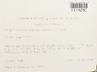 Campylium chrysophyllum (Brid.) Lange 852919[1114230]Frank D Bowers 230041994-09-17 United States, Minnesota, Lake, Heartbreak Creek cRNA, old growth white cedar; ca. 3 km NNE cf Schroeder, west of Road 343, 47.583333 -90.916667 |
MIN:Bryophytes | 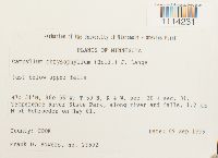 Campylium chrysophyllum (Brid.) Lange 853163[1114231]Frank D. Bowers 235921995-09-09 United States, Minnesota, Cook, Temperence River State Park, along river and falls, 1.2 km N of Schroeder on Hwy 61, 47.516667 -90.933333 |
MIN:Bryophytes | 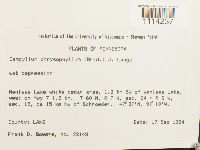 Campylium chrysophyllum (Brid.) Lange 852348[1114237]Frank D Bowers 231431994-09-17 United States, Minnesota, Lake, Wanless Lake white cedar area, 1.2 km SW of Wanless, west on Hwy 7 1.2 km. ca 15 km NW of Schroeder, 47.616667 -91.166667 |
Google Map
Google Maps is a web mapping service provided by Google that features a map that users can pan (by dragging the mouse) and zoom (by using the mouse wheel). Collection points are displayed as colored markers that when clicked on, displays the full information for that collection. When multiple species are queried (separated by semi-colons), different colored markers denote each individual species.