University of Minnesota
http://www.umn.edu/
612-625-5000
http://www.umn.edu/
612-625-5000
Minnesota Biodiversity Atlas
Bell Museum
Dataset: MIN-Plants
Search Criteria: USA OR United States OR U.S.A. OR United States of America; excluding cultivated/captive occurrences
Bell Museum plants | |
 MIN:Plants | 589393[1337959]Blanchard, G. United States, Montana, Flathead, Detailed locality information protected. This is typically done to protect rare or threatened species localities. |
MIN:Plants |  Salix pedicellaris Pursh 477251[1091728]Gerdes, Lynden 39452000-06-04 United States, Minnesota, Lake, Isabella. Approx. 0.25 mile NW of Tony Lake and 0.2 mile east of Highway 1.;Superior National Forest;061N;10W;32, 47.61713 -91.354871 |
MIN:Plants |  699628[1254900]Ziegler, S.; et al. 26171975-09-12 United States, Wisconsin, Vernon, Island 3; Mississippi River-mile #685.1; Small island W side of main channel;Upper Mississippi National Wildlife Refuge;014N;07W;32, 193m |
MIN:Plants |  Dichanthelium ovale subsp. villosissimum (Nash) Freckmann & Lelong 455366[1063721]Hammer, W. s.n.2002-07-02 United States, Minnesota, Ramsey, Arden Hills. Twin Cities Army Ammunition Plant-Arden Hills Army Training Site. Grassland management unit 14. NW1/4 SE1/4 of section;;030N;23W;15, 45.089981 -93.162935 |
MIN:Plants |  435112[1084023]Nation, R. 94-3401994-07-24 United States, Minnesota, Mower, Lake Louise State Park. Mower Co.; Tract 4A. T101N R14W NW1/4 of NW1/4 of Sec. 28;Lake Louise State Park;101N;14W;28, 43.522099 -92.518958 |
MIN:Plants | Gaultheria hispidula (L.) Muhlenberg ex Bigelow 477795[]Lee, Michael; et al. MDL22971998-07-28 United States, Minnesota, Crow Wing, Crow Wing County ... forested bog 5-1/2 miles south of Emily ... T137N R26W NW1/4 of SW1/4 Sec. 28;;137N;26W;28, 46.6514714 -93.9778098 |
MIN:Plants |  Bolboschoenus fluviatilis (Torrey) Soj 907765[1006398]Smith, Welby; et al. 310892008-08-06 United States, Minnesota, Saint Louis, Boundary Waters Canoe Area Wilderness / Superior National Forest. St. Louis County...Meat Lake in the Boundary Waters Canoe Area Wilderness, Superior National Forest...T63N R 14W SE1/4 of SE1/4 of Sec 22. 063N 14W 22, 47.9197222 -92.0980556 |
MIN:Plants |  906276[1344254]Loso, Stephanie; et al. 10722007-07-11 United States, Minnesota, Cass, Cass County...Ada Lake...utm: N: 5186951 E: 398057. DNR Site# 800;;139N;29W;00, 46.828297 -94.33663560199784 |
MIN:Plants | Rhus glabra L. 428973[]Smith, Welby 288792000-08-02 United States, Minnesota, Goodhue, Goodhue County ... Frontenac State Park, about 2 miles N-NE of Frontenac ... T 112N R 13W NW1/4 of SE1/4 of Sec 2;Frontenac State Park;112N;13W;02, 44.5341667 -92.335 |
MIN:Plants |  Ribes americanum Miller 491521[1021993]Capistrant, A. AMC11431998-05-14 United States, Minnesota, McLeod, T115N R29W S34;Schaefer Prairie, The Nature Conservancy;115N;29W;34, 44.72505 -94.30491 |
MIN:Plants | 510092[]US Nat. Arboretum staff 441978-00-00 United States, Ohio, Hamilton, Hamilton Co. |
MIN:Plants |  Physalis virginiana Miller 499835[1005932]Harris, Fred 962251996-08-28 United States, Minnesota, Sibley, Sibley County ... 5 miles west of Henderson ... Rush River Valley ... on the Wells-Rush River Ground Moraine ... T 112N R 26W NW1/4 of NW1/4 of sec 7. T112N R26W S7, 44.519548 -94.003688 |
MIN:Plants |  Osmorhiza claytonii (Michaux) C.B. Clarke 573795[1035228]Scott, P. 16232003-08-21 United States, Minnesota, Saint Louis, ST. LOUIS CO ... Devil's Cascade Portage, BWCAW. T66N R15W sec. 15 NENWNW.;Boundary Waters Canoe Area Wilderness / Superior National Forest;066N;15W;15, 48.199898 -92.244751 |
MIN:Plants |  416083[1066080]Spetzman, L. 3767b1950-07-04 United States, Alaska, Arctic North Slope ... Kurupa Lake;Gates of the Arctic National Park;;;, 68.3666667 -154.6666667, 945m |
MIN:Plants |  Elymus elymoides subsp. elymoides (Rafinesque) Swezey 235995[1064720]Congdon, J. s.n.1902-06-15 United States, California, Mariposa, Mormon Bar;Yosemite National Park;;;, 37.46222 -119.94694 |
MIN:Plants |  Amelanchier NULL 479100[1283659]Little Jr., Elbert 427691991-07-22 United States, Minnesota, Cook, Cook County...Near Hovland, 20 mi NE of Grand Marais, N shore of Lake Superio;Grand Portage State Forest / North Shore;062N;04E;, 47.954739 -90.029827 |
MIN:Plants |  Carex crawfordii Fernald 482398[1008954]Anderson, Craig 9232000-06-20 United States, Minnesota, Pope, Pope Co.; T125N R36W: 1/4 of NE1/4 of SW1/4 of Sect. 29;Grove Lake Wildlife Management Area;125N;36W;29, 45.606838 -95.232635 |
MIN:Plants |  Populus grandidentata Michaux 912463[1092928]Smith, Welby 230281993-07-21 United States, Minnesota, Meeker, Meeker County...At the south end of Long Lake, about 1 mile north of Dassel...T 119N R 29W SW1/4 of SE1/4 of Sec 22;;119N;29W;22, 45.0977778 -94.3030556 |
MIN:Plants |  539866[1074853]Tester, John s.n.1957-07-15 United States, Minnesota, Mahnomen, 3-4 miles w. and 1 mile s. of Waubun. ;Waubun Prairie Wildlife Management Area / White Earth Indian Reservation;143N;42W;33, 47.1589041 -96.0074302 |
MIN:Plants |  Populus grandidentata Michaux 484366[1092942]Juhnke, C. 344 CMJ FRO1999-06-10 United States, Minnesota, Goodhue, Frontenac State Park. Frontenac State Park Goodhue County ... Near bench at prairie/woods edge at overlook north of contact station ... T112N R13W SE NW SE 2. 112N 13W 2, 44.533966 -92.339251 |
MIN:Plants | Micranthes nivalis (L.) Small 239190[]Congdon, J. s.n.1890-08-12 United States, California, Mariposa, Buck Camp, Mariposa County;Yosemite National Park |
MIN:Plants |  480851[1057394]Smith, Welby 166181990-05-17 United States, Minnesota, Martin, East Chain Wildlife Management Area. Martin County ... East Chain State Wildlife Management Area, about 1.5 miles north of the town of East Chain ... T 101N R 29W NE1/4 of SW1/4 of Sec 6. 101N 29W 6, 43.5797222 -94.3577778 |
MIN:Plants | Coeloglossum viride (L.) Hartman 900931[1304568]Lee, Michael United States, Minnesota, Becker, Detailed locality information protected. This is typically done to protect rare or threatened species localities. |
MIN:Plants | 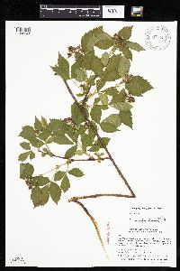 Rubus satis L.H. Bailey 911325[1032749;1032748]Smith, Welby; Gerdes, Lynden B. 310222008-07-22 United States, Minnesota, Lake, Near the southeast end of Fourtown Lake. SE1/4 of SE1/4 of Section;Boundary Waters Canoe Area Wilderness / Superior National Forest;065N;11W;31, 48.0669444 -91.7822222 |
MIN:Plants | 197064[]G. & L. s.n.1885-08-02 United States, Minnesota, Chippewa, Montevideo;;117N;40W;, 44.93463 -95.67577 |
MIN:Plants |  699670[1019516]Ziegler, S.; et al. 15501975-07-02 United States, Wisconsin, Vernon, Vernon Co.; Island 4, Mississippi River-mile #696.7; T14N R7W Sec 19 ... Large island E side of main channel;Upper Mississippi National Wildlife Refuge;014N;07W;19, 193m |
MIN:Plants |  Persicaria punctata (Elliott) Small 910700[1087125]Rowe, Erika ERR2962007-07-31 United States, Minnesota, Hubbard, Hubbard County...0.25 miles south of 174th St.; 4.25 miles SW of Nevis...east side of Crow Wing River...T140N R33W SESW S29. 140N 33W 29, 46.91 -94.8861111 |
MIN:Plants | Cerastium axillare Correll 108284[]Metcalfe, O. 1991903-06-20 United States, New Mexico, Grant, Collected in the Burro Mountains, Grant County, 2134m |
MIN:Plants |  462329[1091012]Smith, Welby 281221999-08-06 United States, Minnesota, Aitkin, Savanna State Forest. Aitkin County ... Just south of where the Sandy River crosses hwy 65 at Big Sandy lake ... T 49N R 23W SW1/4 of NE1/4 of Sec 19. 049N 23W 19, 46.7208333 -93.3041667 |
MIN:Plants |  Carex tuckermanii Dewey 471820[1017651]Gerdes, Lynden 39602000-06-12 United States, Minnesota, Lake, North Shore / Tettegouche State Park. T56N R07W S18NENW Lake County ... Tettegouche State Park ... Approximately .25 mile SW of Tettegouche Lake. Pond is adjacent to main hiking trail & south of the Cedar Lake spur trail.. 056N 07W 18, 47.336163 -91.272302 |
MIN:Plants |  Eriogonum pauciflorum Pursh 550696[1085093]Cotter, Shirley 8121950-06-15 United States, South Dakota, Pennington, Pennington Co. ... Badlands east of Rapid City, along highway 16;Badlands National Monument |
MIN:Plants |  Melica spectabilis Scribner 764002[1068130]Scribner, F. s.n. United States, Wyoming, Park, Yellowstone Park;Yellowstone National Park |
MIN:Plants |  Scirpus pedicellatus Fernald 438377[1021886]Carlson, Bruce Wypt 7992005-08-24 United States, Minnesota, Saint Louis, Superior National Forest. St. Louis County...4.4km east of Hoyt Lakes, 7.5km NW of Skibo, 0.8km NNE of the Allen Junction bridge...east side of the Partridge River...T58N R14W SWSW11. 058N 14W 11, 47.525163 -92.081885 |
MIN:Plants |  Agrostis gigantea Roth 913640[1059176]Smith, Welby 228201993-07-12 United States, Minnesota, Freeborn, Freeborn County...Between CSAH 46 and the Soo Line Railroad tracks, about 8 miles east of Albert Lea...T 102N R 20W NW1/4 or SW1/4 of Section 1. T102N R20W S1, 43.666432 -93.179093 |
MIN:Plants |  409831[1026459]Spetzman, L. 17201949-07-07 United States, Alaska, Arctic North Slope ... Anaktuvuk Pass;Gates of the Arctic National Park;;;, 68.2833333 -151.4166667, 914m |
MIN:Plants |  Acacia koa A. Gray 762262[1299113]Degener, O.; et al. 357021982-10-12 United States, Hawaii, Hawaii, near David Douglas Monument, Mauna Kea, 1829m |
MIN:Plants | 289154[]Beardslee, H.; et al. s.n.1891-07-25 United States, North Carolina, Swain, Great Smoky Mountains...Tuckaseegee River, Swain County;Great Smoky Mountains National Park, 518m |
MIN:Plants |  Eleocharis ovata (Roth) Roemer & Schultes 489152[1020515]Gerdes, Lynden 49522004-09-10 United States, Minnesota, Lake, Superior National Forest. T61N R08W S36SWSE. Lake County...Superior National Forest. Approximately 7.61 miles NNE of Isabella, MN. Northeast shores of Jack Lake.. 061N 08W 36, 47.721777 -91.287816 |
MIN:Plants |  Salix amygdaloides Andersson 907098[1089887]Smith, Welby 308952008-06-12 United States, Minnesota, Benton, Benton County...Wisneski State Wildlife Management Area, about 5 miles east of Rice...T38N R30W SW1/4 of SW1/4 of Sec 29;Wisneski Wildlife Area;038N;30W;29, 45.7530556 -94.1077778 |
MIN:Plants |  Botrychium michiganense W.H. Wagner ex A.V. Gilman, Farrar & Zika 920436[1082523]MacFarlane, Malcolm 932009-06-07 United States, Minnesota, Roseau, E of the intersection of Hwy 5 and Thompson FR. SW of section;Beltrami Island State Forest;161N;36W;29, 48.732222 -95.324444 |
MIN:Plants | 906336[]Gerdes, Lynden; et al. 54532007-07-03 United States, Minnesota, Lake, Fish Fry Lake approx. 4.68 miles NW of Isabella, MN. NE of boat landing.;Superior National Forest;060N;09W;26, 47.6535424 -91.4380225 |
MIN:Plants |  Scirpus cyperinus (L.) Kunth 524466[1021842]Benner, J. s.n.1948-07-15 United States, Wisconsin, Polk, Island five miles north of St. Croix Falls;Saint Croix National Riverway;;;, 45.488738 -92.698239 |
MIN:Plants | Rhus typhina L. 478570[]US Nat. Arboretum staff 121978-00-00 United States, Maryland, Frederick, [no further data] |
MIN:Plants | 510370[]Arboretum, Cary 73-171973-00-00 United States, New York, Dutchess, Dutchess Co. |
MIN:Plants |  Solidago nemoralis Aiton 358458[1050869]Tryon, R. 42721939-09-16 United States, Indiana, Porter, E end of Indiana Dunes State Park, 2 miles N of Furnessville, Porter Co.;Indiana Dunes National Lakeshore;;;, 41.663093 -87.032128 |
MIN:Plants |  Tetraneuris acaulis (Pursh) Greene 303604[1053729]Goddard, David 5351927-06-09 United States, Arizona, Coconino, Bright Angel Trail, 500 feet below the rim, Grand Canyon of the Colorado.;Grand Canyon National Park, 1951m |
MIN:Plants |  292693[1000649]Lunell, J. s.n.1909-07-00 United States, North Dakota, Benson, [about the city of] Leeds |
MIN:Plants |  Ribes lacustre (Persoon) Poiret 905252[1022854]Gerdes, Lynden 44432001-08-02 United States, Minnesota, Lake, T56N R07W S17SENW. Lake County...Tettegouche State Park. Mt. Trudee. Silver Bay, MN.;North Shore / Tettegouche State Park;056N;07W;17, 47.33614 -91.25087 |
MIN:Plants |  912079[1018123]Rowe, Erika ERR2632007-07-24 United States, Minnesota, Hubbard, Paul Bunyan State Forest. Hubbard County...0.5 mile east of State Hwy 64; 10 meters south of Kabekona Forest Rd in Paul Bunyon SF...T142N R32W NWNW S16. 142N 32W 16, 47.1188889 -94.7441667 |
MIN:Plants | Cypripedium parviflorum var. makasin (Farwell) Sheviak 915826[1308216]Whitfeld, T.J.S. United States, Minnesota, Hubbard, Detailed locality information protected. This is typically done to protect rare or threatened species localities. |
MIN:Plants |  Glyceria striata (Lamarck) Hitchcock 911885[1066941]Smith, Welby 247211994-07-13 United States, Minnesota, Polk, Polk County...About two miles north of the town of Gully...T 150N R 39W NW1/4 of NW1/4 of Sec 23;Gully Fen Scientific Natural Area;150N;39W;23, 47.8008333 -95.615 |
MIN:Plants | Urtica dioica subsp. gracilis (Aiton) Selander 898984[]Smith, Welby 258041995-08-01 United States, Minnesota, Swift, Swift County...Monson Lake State Park...T 121N R 37W NE1/4 of NW1/4 of Sec 1;Monson Lake State Park;121N;37W;01, 45.3236111 -95.2688889 |
MIN:Plants | Carex media R. Brown ex Richardson 438958[1013497]Lee, Michael United States, Minnesota, Lake, Detailed locality information protected. This is typically done to protect rare or threatened species localities. |
MIN:Plants |  Carex eburnea Boott 461038[1010095]Wheeler, Gerald 157381997-05-24 United States, Minnesota, Nicollet, Near Fort Ridgely State Park, just E of the jct. of Rte. 4 and Rte. 5. SW1/4 NE1/4 SW1/4 of section;;111N;32W;05, 44.449166 -94.715206 |
MIN:Plants | Orthocarpus luteus Nuttall 419858[]Lakela, Olga 107581950-07-23 United States, Minnesota, Saint Louis, on Duluth Heights near Highway 53, Duluth;;050N;14W;00, 46.7833 -92.1 |
MIN:Plants | Enemion biternatum Rafinesque 476649[]Kaul, R. 67221990-05-01 United States, Minnesota, Steele, Steele Co.; along Straight River; Kaplan's Woods.;;107N;20W;, 44.05993 -93.237086 |
MIN:Plants |  Tripleurospermum inodorum (L.) Schultz-Bipontinus 491437[1053756]Gerdes, Lynden 35621999-07-10 United States, Minnesota, Cook, West of active gravel pit; approx. 0.25 mile north of the Gunflint Trail (Cty. 12) & FR 1347 junction; west off FR 1347;Superior National Forest;065N;04W;26, 48.084497 -90.803753 |
MIN:Plants |  257052[1085157]Nelson, Aven; et al. 62921899-08-03 United States, Wyoming, Park, Yellowstone National Park ... Iron Spring Creek;Yellowstone National Park |
MIN:Plants |  Cheilanthes gracillima D.C. Eaton 220340[1315814]Stork, H.E. 641923-07-11 United States, Montana, Glacier Natl. Park;Glacier National Park;;;, 48.63333 -113.75028 |
MIN:Plants |  Stellaria longifolia var. atrata John W. Moore 415424[1002574]Moore, John; Moore, Marjorie 111351939-07-25 United States, Minnesota, Lake of the Woods, east side of Pine Creek, Angle Inlet;Northwest Angle;168N;34W;29, 49.345221 -95.059408 |
MIN:Plants |  Leymus cinereus (Scribner & Merrill) A. L̦ve 64705[1068042]Burglehaus, F. s.n.1894-08-21 United States, Wyoming, Park, Near Mammoth Hot Springs;Yellowstone National Park, 2134m |
MIN:Plants |  Carex intumescens Rudge 221953[1012261]Cooper, William 3311909-08-10 United States, Michigan, Keweenaw, Lake Richie, Isle Royale;Isle Royale National Park |
MIN:Plants | Nuphar variegata Durand 912173[]Smith, Welby 230921993-07-22 United States, Minnesota, Carver, Carver County...At the northwest end of Lake St. Joe, about 2 mi north of Chaska...T 116N R 23W NE1/4 of NE1/4 of sec 7;;116N;23W;07, 44.875 -93.625 |
MIN:Plants |  921325[1050930]Smith, Welby 182431990-08-30 United States, Minnesota, Morrison, Camp Ripley Military Reservation. Camp Ripley Military Reservation. Morrison County...At the old Fort Ripley ruins...UTM: 393900E 5114300N. T131N R29W SW1/4 of NE1/4 of Sec 7. 131N 29W 7, 46.1758333 -94.3744444 |
MIN:Plants | Woodsia oregana subsp. cathcartiana (B.L. Robinson) Windham 914801[]Gerdes, Lynden B. 59492009-09-15 United States, Minnesota, Cook, Superior National Forest. Just south of the Boundary Waters Canoe Area Wilderness Royal River corridor. Approximately 0.24 miles southeast of the eastern end of the John Lake-Royal River portage. T64N R03E S03NWSESWNE, 48.0591667 -90.0425 |
MIN:Plants |  Carex prairea Dewey 438477[1015021]Smith, Welby 256141995-05-16 United States, Minnesota, Lyon, Lyon County...In Camden State Park, about 10 miles southwest of Marshall...T 110N R 42W NE1/4 of SE1/4 of Sec 5;Camden State Park;110N;42W;05, 44.36 -95.9172222 |
MIN:Plants |  699652[1043753]Ziegler, S.; et al. 12701975-06-17 United States, Wisconsin, La Crosse, LaCrosse Co. Island 18; Mississippi River-mile #693.3; T15N R7W Sec 29...Island on E side of main channel...southern end;Upper Mississippi National Wildlife Refuge;015N;07W;29, 194m |
MIN:Plants |  Grayia spinosa (Hooker) Moquin-Tandon 794895[1037528]Schaaf, J. 261982-07-08 United States, Nevada, Carson City, Carson City Co. ... Prison Hill, 1554m |
MIN:Plants |  914636[1070790]Smith, Welby 225761993-06-22 United States, Minnesota, Stevens, Hornings Pit Wildlife Management Area. Stevens County...Horning's Pit State Wildlife Management Area, about 10 miles west-northwest of Donnelly...T 126N R 44W SW1/4 of NE1/4 of Sec 18. 126N 44W 18, 45.7244444 -96.2433333 |
MIN:Plants | Cerastium velutinum var. velutinum Rafinesque 247233[]Chase, Agnes 21811904-05-13 United States, Maryland, Potomac Valley ... Col [?] Canal, N. of Cabin John |
MIN:Plants |  Rhamnus alnifolia L'H̩ritier 438994[1057191]Smith, Welby 261461996-06-11 United States, Minnesota, Saint Louis, St. Louis County ... Superior National Forest ... Little Indian Sioux River ... T65N R15W NW1/4 of NW1/4 of Sec 1;Superior National Forest;065N;15W;01, 48.1486111 -92.2013889 |
MIN:Plants |  Impatiens capensis Meerburgh 461109[1134024]Schik, K. 95-1241995-08-24 United States, Minnesota, Wilkin, Wilkin Co, T133N R47W SW1/4 of the SE1/4 of S33; Red River.;;133N;47W;33, 46.290504 -96.59596 |
MIN:Plants |  Cheilanthes alabamensis (Buckley) Kunze 283285[1315677]Moore, J. 33631931-07-04 United States, Texas, Brewster, Chisos Mountains. Near head of Oak Canyon [Big Bend National Park], 29.0689 -103.4503, 1370m |
MIN:Plants |  Nassella viridula (Trinius) Barkworth 235668[1069020]Congdon, J. s.n.1890-08-14 United States, California, Mariposa, Bridal Veil Creek, Mariposa County;Yosemite National Park |
MIN:Plants | Juncus marginatus Rostkovius 488073[1141139]Husveth, J. United States, Minnesota, Anoka, Detailed locality information protected. This is typically done to protect rare or threatened species localities. |
MIN:Plants |  Carex vulpinoidea Michaux 484266[1018353]Husveth, J. 96-2521996-07-09 United States, Minnesota, Hennepin, Hennepin County ... T119N R25W SW1/4 of the NE1/4 of S2;;119N;25W;02, 45.144089 -93.796362 |
MIN:Plants |  Persicaria maculosa A. Gray 454974[1086109]Biederman, L. 3371999-07-30 United States, Minnesota, Jackson, Jackson County ... along the Des Moines River (Holthe Scientific and Natural Area) ... T103N R35W NESW08;Holthe Prairie Scientific Natural Area;103N;35W;08, 43.739253 -95.06531 |
MIN:Plants |  Carex merritt-fernaldii Mackenzie 488822[1007884]Gerdes, Lynden; Walewski, J. 37411999-08-05 United States, Minnesota, Cook, East end of Hungry Jack Lake on the Honeymoon Bluff Trail/Overlook. SENW of section;Superior National Forest;064N;01W;02, 48.055879 -90.415017 |
MIN:Plants |  Heracleum lanatum Michaux 656999[1035029]Noble, Mark; et al. 5021974-08-05 United States, Alaska, Muir Point; from site deglaciated ca. 1880.;Glacier Bay National Park;;;, 58.82694 -136.07722 |
MIN:Plants | 461191[]Gerdes, Lynden; et al. 32231998-08-26 United States, Minnesota, Cook, T64N R02E S07NWNE. Cook County; Superior National Forest, East of Pierz Lake in a Picea mariana swamp.;Superior National Forest;064N;02E;07, 48.0412899 -90.2417439 |
MIN:Plants | Saxifraga cespitosa (Small) Hult̩n 409355[]Spetzman, L. s.n.1949-07-14 United States, Alaska, Arctic North Slope ... Anaktuvuk Pass;Gates of the Arctic National Park;;;, 68.2833333 -151.4166667, 610m |
MIN:Plants | Bistorta vivipara (L.) Delarbre 700088[1084945]Glaser, Paul United States, Alaska, Detailed locality information protected. This is typically done to protect rare or threatened species localities. |
MIN:Plants | Platanthera clavellata (Michaux) Luer 459753[1317206]Scott, P. United States, Minnesota, Cook, Detailed locality information protected. This is typically done to protect rare or threatened species localities. |
MIN:Plants | Claytonia acutifolia Pallas ex Willdenow 699940[]Glaser, Paul 7941975-06-28 United States, Alaska, Mt. McKinley National Park...N1/2 SW1/4Sec.18 T17S R14W, Thorofare Bluffs;Denali National Park;017S;14W;18, 1372m |
MIN:Plants |  Populus deltoides subsp. monilifera (Aiton) Eckenwalder 484320[1092859]Smith, Welby 168611990-06-18 United States, Minnesota, Waseca, Senn-Rich Wildlife Management Area. Waseca County...Senn-Rich State Wildlife Management Area, about 5 miles south of Waseca...T 106N R22W SE1/4 of NW1/4 of Sec 8.. 106N 22W 8, 44.0022222 -93.4977778 |
MIN:Plants |  Salix pedicellaris Pursh 483681[1091775]Gerdes, Lynden 29781998-07-18 United States, Minnesota, Cook, West of Royal Lake, just north and adjacent to the Royal River. NESE of section;Boundary Waters Canoe Area Wilderness / Superior National Forest;064N;03E;03, 48.05 -90.0167 |
MIN:Plants |  Cyclachaena xanthiifolia (Nuttall) Fresenius 479080[1042767]Wheeler, Gerald 174931997-08-31 United States, Minnesota, Renville, W side of Bird Island, N side of Rte. 212. N1/2 NW1/4 of section;;115N;34W;14, 44.767523 -94.905151 |
MIN:Plants |  Pinus resinosa Aiton 478185[1003794]Smith, Welby 269171998-04-22 United States, Minnesota, Koochiching, Koochiching County ... Along County Road 5, about 2 miles Northwest of Craigville ... T63N R26W SW1/4 of SW1/4 of Sec 23;Koochiching State Forest;063N;26W;23, 47.9297222 -93.6383333 |
MIN:Plants |  Panicum verrucosum Muhlenberg 531769[1069493]Umbach, L. 46001900-08-23 United States, Indiana, Porter, Northern Porter County...Dune Park on Lake Michigan (7 mi. E. of Gary, Ind, SE. of Chicago);Indiana Dunes National Lakeshore;;;, 41.663093 -87.032128 |
MIN:Plants |  Dryopteris expansa (C. Presl) Fraser-Jenkins & Jermy 432675[1305881]Gerdes, Lynden 40402000-07-12 United States, Minnesota, Lake, North Shore. T57N R06W S19NWSW. Lake County...Little Marais...approximately 1/2 mile ESE of the Superior Hiking Trail and County 6 junction. Approx. 0.85 mile ESE of the Finland Cemetary.. 057N 06W 19, 47.583104 -91.421915 |
MIN:Plants |  Corylus americana Walter 511741[1095855]Smith, Welby 275971999-04-05 United States, Minnesota, Anoka, Carlos Avery Wildlife Management Area. Anoka County ... Carlos Avery State Wildlife Management Area; about 4 miles W-SW of wyoming (town) ... T 33N R 22W NW1/4 of NW1/4 of Sec 28. 033N 22W 28, 45.3233333 -93.1008333 |
MIN:Plants | 909219[]Smith, Welby 218791992-09-03 United States, Minnesota, Watonwan, Watonwan County...At the public access on the north side of Fedji Lake, about 2 miles northeast of Madelia...T 107N R 30W SW1/4 of SW1/4 of Sec 12. 107N 30W 12, 44.0816667 -94.3880556 |
MIN:Plants | Zigadenus elegans Pursh 399231[]Spetzman, L. 3561947-07-23 United States, Alaska, Canning River ... where river leaves mountains;Arctic National Wildlife Refuge;;;, 69.2833333 -146 |
MIN:Plants | Pleiacanthus spinosus (Nuttall) Rydberg 499341[]Went, F. s.n.1973-06-04 United States, California, Inyo, Death Valley, Inyo Co.;Death Valley National Park |
MIN:Plants |  Physalis virginiana Miller 914574[1006022]Smith, Welby 226041993-06-29 United States, Minnesota, Swift, Swift County...Between U.S. Highway 12 and the BN railroad tracks, about 4 miles southeast of Benson...T 121N R 39W SW1/4 of SW1/4 of Sec 13. 121N 39W 13, 45.2838889 -95.5194444 |
MIN:Plants |  Carex fuliginosa Schkuhr 408269[1010640]Spetzman, L. 18921949-07-11 United States, Alaska, Arctic North Slope ... Anaktuvuk Pass;Gates of the Arctic National Park;;;, 68.2833333 -151.4166667, 762m |
MIN:Plants |  349573[1050028]Engleman, J.; et al. 32951935-08-06 United States, Colorado, Devil's Gulch ... Rocky Mountain National Park;Rocky Mountain National Park, 2438m |
MIN:Plants | Platanthera obtusata (Banks ex Pursh) Lindley 432323[1317769]Lee, Michael United States, Minnesota, Lake, Detailed locality information protected. This is typically done to protect rare or threatened species localities. |
MIN:Plants | Lonicera caerulea var. villosa (Michaux) Torrey & A. Gray 896943[]Lake, Roger 01-52001-05-20 United States, Minnesota, Saint Louis, St. Louis County...T 59N R 21W NW1/4 of NE1/4 of Sec 1;Superior National Forest;059N;21W;01, 47.6246 -92.943311 |
MIN:Plants |  Eleocharis bolanderi A. Gray 234037[1019915]Congdon, J. s.n.1895-05-19 United States, California, Mariposa, Aqua Fria Canyon, Mariposa County;Yosemite National Park |
Google Map
Google Maps is a web mapping service provided by Google that features a map that users can pan (by dragging the mouse) and zoom (by using the mouse wheel). Collection points are displayed as colored markers that when clicked on, displays the full information for that collection. When multiple species are queried (separated by semi-colons), different colored markers denote each individual species.