University of Minnesota
http://www.umn.edu/
612-625-5000
http://www.umn.edu/
612-625-5000
Minnesota Biodiversity Atlas
Bell Museum
Dataset: MIN-Plants
Search Criteria: USA OR United States OR U.S.A. OR United States of America; excluding cultivated/captive occurrences
Bell Museum plants | |
 MIN:Plants |  Crataegus macracantha Loddiges 440627[1026026]Smith, Welby 277691999-05-22 United States, Minnesota, Wadena, About 4.5 miles south of Sebeka. NE1/4 of NE1/4 of section;;136N;35W;34, 46.5558333 -95.0736111 |
MIN:Plants |  431988[1025819]Smith, Welby 265381997-05-27 United States, Minnesota, Washington, In the St. Croix Valley, about 1.5 miles north of Marine. SW1/4 of SW1/4 of Sec;William O'Brien State Park;032N;19W;30, 45.225 -92.76 |
MIN:Plants | Maianthemum racemosum subsp. racemosum (L.) Link 510308[]Kaul, R.; et al. 50531985-05-26 United States, Minnesota, Steele, Steele County ... in Kaplan's Woods park, south edge of Owatonna.;;107N;20W;, 44.062228 -93.235738 |
MIN:Plants |  Bistorta plumosa (Small) Greene 413397[1084879]Spetzman, L. 15791949-07-01 United States, Alaska, Arctic North Slope ... Anaktuvuk Pass;Gates of the Arctic National Park;;;, 68.2833333 -151.4166667, 610m |
MIN:Plants |  Cystopteris fragilis (L.) Bernhardi 476798[1321681]Gerdes, Lynden 25911998-06-03 United States, Minnesota, Cook, T65N R01E S27NESW. Cook County ... Superior National Forest, BWCAW, Clearwater Lake. Cliff 3.;Boundary Waters Canoe Area Wilderness / Superior National Forest;065N;01E;27, 48.087449 -90.322587 |
MIN:Plants |  Fallopia scandens (L.) Holub 435195[1085760]DeMink, L. 3372000-09-17 United States, Minnesota, Morrison, Crane Meadows National Wildlife Refuge; SESE 19-T40N-R31W;Crane Meadows National Wildlife Refuge;040N;31W;19, 45.948427 -94.250523 |
MIN:Plants |  Osmorhiza longistylis (Torrey) de Candolle 919820[1035325]Smith, Welby 222621993-06-02 United States, Minnesota, Watonwan, Watonwan County ... At the public access on the north side of Fedji Lake, about 2 miles northeast of Madelia ... T107N R30W SW1/4 of SW1/4 of Sec 12. 107N 30W 12, 44.0816667 -94.3880556 |
MIN:Plants |  Selaginella rupestris (L.) Spring 432676[1383877]Gerdes, Lynden 41172000-07-20 United States, Minnesota, Lake, North Shore / Tettegouche State Park. T56N R08W S24NESE. Lake County...Tettegouche State Park, approximately 1.75 miles north of Silver Bay, MN. Prominent SE-facing cliff feature.. 056N 08W 24, 47.33958 -91.198054 |
MIN:Plants |  Dryopteris carthusiana (Villars) H.P. Fuchs 220442[1324509]Cooper, William 1001909-07-14 United States, Michigan, Keweenaw, Raspberry Id. Isle Royale;Isle Royale National Park;;;, 48.010955 -88.828422 |
MIN:Plants | 351652[]Courtney, Althea s.n.1931-05-11 United States, Tennessee, DeKalb, North Alexandria |
MIN:Plants | 360373[]Lakela, Olga 37401940-07-20 United States, Minnesota, Carlton, St. Louis River gorge, Carlton Co. [this is probably now Jay Cooke SP];Jay Cooke State Park;048N;16W;, 46.6342494 -92.3645882 |
MIN:Plants | 794810[]Schaaf, J. 1131982-07-26 United States, Nevada, Pershing, Pershing Co. ... Rye Patch Reservoir ... Elev.: 4160 ft. |
MIN:Plants |  Carex pluriflora Hult̩n 382605[1014843]Morse, Marius s.n.1944-07-17 United States, Alaska, Aleutian Islands ... Adak Island;Aleutian Islands Wilderness;;;, 51.88 -176.65806 |
MIN:Plants |  475037[1028224]Scott, P. 11751999-08-20 United States, Minnesota, Cook, Cook Co. Caribou Rock, Superior National Forest. T65N R1W sec. 33 SESWSE.;Superior National Forest;065N;01W;33, 48.069999 -90.459509 |
MIN:Plants |  911859[1064290]Smith, Welby 218701992-09-03 United States, Minnesota, Watonwan, Watonwan County...At the public access on the north side of Fedji Lake, about 2 miles northeast of Madelia...T 107N R 30W SW1/4 of SW1/4 of Sec 12. 107N 30W 12, 44.0816667 -94.3880556 |
MIN:Plants |  896589[1057427]Smith, Welby 292962002-06-11 United States, Minnesota, Wright, Wright County...Harry Larson County Forest, about 7 miles W-NW of Monticello...T 122N R 26W SW1/4 of SW1/4 of Sec 35;Harry Larson County Forest;122N;26W;35, 45.33323 -93.92151 |
MIN:Plants |  Potentilla paradoxa Nuttall 129295[1029114]Herrick, C. 49-101878-08-00 United States, Minnesota, Hennepin, L. Minnetonka;;;;, 44.917794 -93.610061 |
MIN:Plants | Goodyera pubescens (Willdenow) R. Brown 431689[1310739]Dahle, R. United States, Minnesota, Aitkin, Detailed locality information protected. This is typically done to protect rare or threatened species localities. |
MIN:Plants |  Muhlenbergia frondosa (Poiret) Fernald 699685[1068419]Ziegler, S.; et al. 28441975-09-22 United States, Wisconsin, La Crosse, LaCrosse Co.; Island 15; Mississippi River-mile #691.6; T15N R7W Sec 31...Small site E side of main channel;Upper Mississippi National Wildlife Refuge;015N;07W;31, 193m |
MIN:Plants |  Carex feta L.H. Bailey 233471[1010484]Congdon, J. s.n.1893-06-15 United States, California, Mariposa, Snow Creek, Mariposa County;Yosemite National Park |
MIN:Plants | Lithospermum latifolium Michaux 911366[]Smith, Welby 253411994-08-30 United States, Minnesota, Scott, Scott County...About 2 miles northeast of Hendreson...T 113N R 25W NW1/4 of NE1/4 of Sec 31;;113N;25W;31, 44.5541667 -93.8763889 |
MIN:Plants |  909790[1030466]Smith, Welby 245901994-07-11 United States, Minnesota, Koochiching, Koochiching County...About three miles east of Northome...south side Tuefer Lake...T 151N R 28W SW1/4 of NE1/4 of Sec 27;;151N;28W;27, 47.8694444 -94.2183333 |
MIN:Plants |  431979[1040274]Paulin, Amy; Wong, Mayee 1997-06-28 United States, Minnesota, Pipestone, UTM 071456N 4876879E;Pipestone National Monument;106N;46W;01, 44.013519 -96.324755 |
MIN:Plants | Tofieldia coccinea Richardson 417000[]Spetzman, L. 41401950-07-17 United States, Alaska, Arctic North Slope ... Noatak & Kugururok R.;Noatak National Preserve;;;, 67.9666672 -161.9166718, 152m |
MIN:Plants |  Corylus americana Walter 899966[1095859]Myhre, K. 17451992-05-11 United States, Minnesota, Cass, Cass County ... Just north of the Crow Wing River at Pillager ... T133N R30W SW1/4 of NW1/4 of Sec 21;;133N;30W;21, 46.317907 -94.462883 |
MIN:Plants |  Carex magellanica Lamarck 479118[1013361]Smith, Welby 158341989-07-20 United States, Minnesota, Mille Lacs, Mille Lacs Kathio State Park. Mille Lacs County...Mille Lacs Kathio State Park, about 5 miles northwest of Onamia...NE1/4 SE1/4 sec. 10, T 42N R 27W. 042N 27W 10, 46.1336111 -93.7272222 |
MIN:Plants |  Liatris aspera Michaux 268851[1286522]Moore, John W. 16421924-08-00 United States, South Dakota, Brookings, Brookings;;;;, 44.31139 -96.79806 |
MIN:Plants | Shepherdia canadensis (L.) Nuttall 515515[]Scott, P. United States, Minnesota, Lake, Detailed locality information protected. This is typically done to protect rare or threatened species localities. |
MIN:Plants |  Carex peckii Howe 909807[1014207]Smith, Welby 245931994-07-11 United States, Minnesota, Koochiching, Koochiching County...About 3 mi east of Northome...south side of Tuefer Lake...T151N R28W SW1/4 of NE1/4 of Sec 27;;151N;28W;27, 47.8694444 -94.2183333 |
MIN:Plants | Linaria canadensis (L.) Dumont de Courset 474228[]Swanson, Gary United States, Minnesota, Sherburne, Detailed locality information protected. This is typically done to protect rare or threatened species localities. |
MIN:Plants | Silene latifolia Poiret 476961[]Kaul, R. 57601987-05-24 United States, Minnesota, Steele, Steele County ... slope above Straight River, Lemond Road.;;107N;20W;, 44.066112 -93.226071 |
MIN:Plants |  Potentilla palustris (L.) Scopoli 477665[1028988]Whitfeld, T.J.S. 2542001-06-27 United States, Minnesota, Kandiyohi, Randall Wildlife Management Area. Kandiyohi County ... Randall WPA. 1/2 mile north of 270 Av. NW; 2 1/2 miles east of US Hwy. 104 ... T122N R36W NW1/4 of NW1/4 of SE1/4 of Section 9. 122N 36W 9, 45.390981 -95.203885 |
MIN:Plants |  Populus trichocarpa Torrey & A. Gray 239993[1096657]Congdon, J. s.n.1899-08-28 United States, California, Mariposa, Yosemite Valley;Yosemite National Park;;;, 37.71639 -119.66417 |
MIN:Plants |  Salix famelica (C. R. Ball) Argus 488064[1090827]Smith, Welby 273821998-07-15 United States, Minnesota, Carver, Carver County ... At the west end of Lake Auburn, in Carver Park ... T 1116N R24W NW1/4 of SW1/4 of Sec 11;Carver Park Reserve County Park;116N;24W;11, 44.8688889 -93.6775 |
MIN:Plants |  Smilax glauca Walter 676780[1299436]Boufford, D.; et al. 160811975-06-02 United States, North Carolina, Jackson, Jackson County ... Across NC Route 107 from Western Carolina University. Cullowhee. |
MIN:Plants |  Carex umbellata Schkuhr ex Willdenow 904340[1017789]Gerdes, Lynden 53582007-05-14 United States, Minnesota, Lake, Superior National Forest. T60N R11W S04 SENWNE Lake County ... Superior National Forest. Approximately 10.0 miles east of Babbitt ... Near western edge of FR 428 ... NAD 83 / 595666 / 5285654. 060N 11W 4, 47.7172222 -91.7244444 |
MIN:Plants | Maianthemum stellatum (L.) Link 454544[]US Nat. Arboretum staff s.n.1981-00-00 United States, New Jersey, Ocean, Ocean Co. |
MIN:Plants |  Carex raynoldsii Dewey 234803[1015320]Congdon, J. s.n.1894-08-15 United States, California, Tuolumne, Soda Springs, Tuolumne County;Yosemite National Park |
MIN:Plants | Uvularia grandiflora Smith 505325[]Scott, P. 16802004-05-21 United States, Minnesota, Saint Louis, St. Louis Co. ... rocky slope by Rice Bay, Vermilion Lake, T63N R15W sec. 35 SWSENW.;Superior National Forest;063N;15W;35, 47.894532 -92.212925 |
MIN:Plants |  75966[1008498]Eggleston, W. 16811899-07-29 United States, New Hampshire, Coos, White Mountains ... Alpine Garden, Mt. Washington |
MIN:Plants | 417940[]Spetzman, L. 41141950-07-17 United States, Alaska, Arctic North Slope ... Noatak & Kugururok R.;Noatak National Preserve;;;, 67.9666667 -161.9166667, 152m |
MIN:Plants | Quercus falcata Michaux 680235[]US Nat. Arboretum staff s.n.1975-09-08 United States, District of Columbia, US National Arboretum. Cultivated |
MIN:Plants |  Carex praegracilis W. Boott 914632[1014891]Smith, Welby 225541993-06-22 United States, Minnesota, Stevens, Stevens County...Between TH 9 and the BN railroad tracks, about 4 miles south-southeast of Donnelly...T 125N R 42W NW1/4 of NE1/4 of Sec 17. 125N 42W 17, 45.6427778 -95.9752778 |
MIN:Plants | 700133[]Glaser, Paul United States, Alaska, Detailed locality information protected. This is typically done to protect rare or threatened species localities. |
MIN:Plants |  Salix barclayi Andersson 676437[1096762]Glaser, Paul 5051972-08-29 United States, Alaska, Mt. McKinley National Park...SW1/4NE1/4Sec.34 T14S R15W, terminus of Muldrow Glacier;Denali National Park;014S;15W;34, 945m |
MIN:Plants | Maianthemum stellatum (L.) Link 89728[]Coville, Frederick; Funston, Frederick 9601891-05-26 United States, California, Inyo, Near Willow Creek. Panamint Mountains.;Death Valley National Park, 1950m |
MIN:Plants |  Potentilla tridentata Aiton 289616[1029479]Rosendahl, C.; Moyle, J. 8631933-07-16 United States, Minnesota, Hubbard, Itasca Park...County: Hubbard. Loc. near Yola [unknown village; may or may not be in the Park];;;;, 47.232178 -95.012236 |
MIN:Plants | Maianthemum stellatum (L.) Link 479296[]Moore, John 1581971-07-01 United States, Minnesota, Sherburne, SE1/4 Sec. 23 Santiago Twp.;;035N;28W;23, 45.508593 -93.789216 |
MIN:Plants | Geranium NULL 510470[]Bright, R. 72-791972-00-00 United States, Idaho, Bear Lake, [no further data] |
MIN:Plants |  428412[1003869]Little Jr., Elbert 427831991-07-24 United States, Minnesota, Cook, Cook Co.; Eagle Mt, Superior National Forest. 10 mi N of Grand Marais;Boundary Waters Canoe Area Wilderness / Superior National Forest;063N;02W;, 47.93319 -90.57404 |
MIN:Plants |  Botrychium virginianum (L.) Swartz 491351[1314764]Biederman, L. 98-221998-06-29 United States, Minnesota, Roseau, Roseau County ... next to railroad track ... T162N R40W 21;;162N;40W;21, 48.775139 -95.810817 |
MIN:Plants |  Rubus uniformis L.H. Bailey 681681[1032854;1032853]Lee, Michael; et al. MDL44322007-07-03 United States, Minnesota, Stearns, St. Johns University Arboretum Woods; four miles west of St. Joseph; southwest of Sagatagan Lake. UTM: 5046836N 390596E. SW1/4 of SW1/4 of NW1/4 of section;;124N;30W;12, 45.56552 -94.39325 |
MIN:Plants | 403530[]Spetzman, L. United States, Alaska, Detailed locality information protected. This is typically done to protect rare or threatened species localities. |
MIN:Plants |  Juncus longistylis Torrey 461953[1141120]Lee, Michael MDL26031999-07-21 United States, Minnesota, Lake, Crosby Manitou State Park / North Shore. Lake County ... Along Hwy 61 three miles northeast of Little Marais, 1/8 mile southwest of Manitou River bridge ... T57N R6W NW1/4 of NE1/4 Sec. 10. 057N 06W 10, 47.4372822 -91.0776779 |
MIN:Plants | Gentiana puberulenta J.S. Pringle 478973[]Wheeler, Gerald United States, Minnesota, Chippewa, Detailed locality information protected. This is typically done to protect rare or threatened species localities. |
MIN:Plants |  Nassella viridula (Trinius) Barkworth 235838[1069023]Congdon, J. s.n.1890-08-15 United States, California, Mariposa, Yosemite Valley;Yosemite National Park;;;, 37.71639 -119.66417 |
MIN:Plants | Pinus ponderosa Douglas ex Lawson & C. Lawson 433632[]Bright, R. 76-101976-00-00 United States, Wyoming, Crook, Crook Co. |
MIN:Plants |  526569[1028740]Merrell, Ted s.n.1947-09-28 United States, Minnesota, Rice, North of St. Olaf. [St. Olaf College];;011N;20W;01, 44.469931 -93.161926 |
MIN:Plants |  Equisetum pratense Ehrhart 907193[1333195]Smith, Welby 308932008-06-12 United States, Minnesota, Benton, Benton County...Wisneski State Wildlife Management Area, about 5 miles east of Rice...T38N R30W SW1/4 of SW1/4 of Sec 29;Wisneski Wildlife Area;038N;30W;29, 45.7530556 -94.1077778 |
MIN:Plants |  209768[1045473]Burglehaus, F. s.n.1894-07-30 United States, Wyoming, Park, Yellowstone Park ... Near Mammoth Hot Springs;Yellowstone National Park, 2134m |
MIN:Plants | Cerastium velutinum var. velutinum Rafinesque 591428[]Mohlenbrock 55731956-04-27 United States, Illinois, Belle Smith Springs |
MIN:Plants |  Carex tribuloides Wahlenberg 699668[1017498]Ziegler, S.; et al. 10781975-06-05 United States, Wisconsin, Vernon, Vernon Co.; Island 8; Mississippi River mile #688.4; T14N R7W Sec 18 ... Large island E side of main channel;Upper Mississippi National Wildlife Refuge, 193m |
MIN:Plants |  Pinus edulis Engelmann 602659[1003974]Fogg, G.; Hall, M. 3181960-07-12 United States, New Mexico, Sandoval, Brandelier [sic] National Monument, in area between Brandelier [sic] and Los Alamos.;Bandelier National Monument, 2040 - 2140m |
MIN:Plants |  Schoenoplectus acutus var. acutus (Muhlenberg ex Bigelow) 462417[1021714]Crowell, Wendy s.n.2001-06-20 United States, Minnesota, Hennepin, Hennepin County, Bryant Lake;;116N;22W;02, 44.884269 -93.429593 |
MIN:Plants | Liparis loeselii (L.) Richard 491657[1313608]Smith, Welby United States, Minnesota, Carver, Detailed locality information protected. This is typically done to protect rare or threatened species localities. |
MIN:Plants | Viola nephrophylla Greene 479093[]Wheeler, Gerald A. 159041997-06-05 United States, Minnesota, Renville, Ca. 3.5 mi. N of Delhi on Rte. 6, 0.2 mi. W of Rte. 6 on unmarked county road; NE1/4 SE1/4 Sec. 24 T114N R36W (Sweded Forest 24). 114N 36W 24, 44.66514 -95.127147 |
MIN:Plants | Platanthera psycodes (L.) Lindley 914519[1317987]Smith, Welby United States, Minnesota, Carlton, Detailed locality information protected. This is typically done to protect rare or threatened species localities. |
MIN:Plants |  Arnica cordifolia Hooker 200086[1039639]Burglehaus, F. s.n.1893-06-00 United States, Wyoming, Park, Mammoth Springs Nat Park;Yellowstone National Park |
MIN:Plants | Urtica dioica subsp. gracilis (Aiton) Selander 454869[]Smith, Welby 206561992-07-07 United States, Minnesota, Winona, Winona County ... About 2.5 mi east-northeast of Lewiston ... along Garvin Brook ... T106N R8W SE1/4 of SW1/4 of Sec 8;Dorer Memorial Hardwood State Forest;106N;08W;8, 43.9936111 -91.8125 |
MIN:Plants |  505400[1040732]Juhnke, C. 142 CMJ FRO1998-10-14 United States, Minnesota, Goodhue, Frontenac State Park. Goodhue County ... along Mississippi River bay ... T112N R13W SE SW SE 12;Frontenac State Park;112N;13W;12, 44.519822 -92.319123 |
MIN:Plants |  Schoenoplectus pungens (Vahl) Palla 482169[1021740]Wheeler, Gerald 170111997-08-08 United States, Minnesota, Swift, Swift Co.; Ca. 5 mi. NNE of Benson, on NW margin of Frovold Lake; NW1/4 SE1/4 Sec. 16 T122N R39W (Benson 16);;122N;39W;16, 45.376026 -95.571928 |
MIN:Plants | Listera cordata var. cordata (L.) R. Brown 439263[1313850]Whitfeld, T.J.S. United States, Minnesota, Otter Tail, Detailed locality information protected. This is typically done to protect rare or threatened species localities. |
MIN:Plants | 479845[]US Nat. Arboretum staff s.n.1981-00-00 United States, Mississippi, Amite, Gloster;;;;, 31.197396 -91.02177 |
MIN:Plants |  511488[1028247]Wheeler, Gerald 165161997-07-01 United States, Minnesota, Yellow Medicine, Yellow Medicine County ... Ca. 5 mi. NE of Echo; Swedes Forest SNA ... NE1/4 SW1/4 SE1/4 Sec. 12 T114N R38W;Swedes Forest Scientific Natural Area;114N;38W;12, 44.690671 -95.367045 |
MIN:Plants |  Crataegus succulenta var. succulenta Schrader ex Link 902974[1026370]Smith, Welby 256431995-06-03 United States, Minnesota, Wright, Wright County...Collinwood County Park, about 3 miles SW of Cokato...T 118N R 28W NE1/4 of SW1/4 of Sec 7;Collinwood County Park;118N;28W;07, 45.0422222 -94.265 |
MIN:Plants |  Ostrya virginiana (Miller) K. Koch 899531[1096331]Smith, Welby 273381998-07-09 United States, Minnesota, Mahnomen, Mahnomen County...On the north side of McCraney Lake, about 12 mi east of Waubun...T143N R40W SE1/4 of NW1/4 of Sec 25;White Earth Indian Reservation / White Earth State Forest;143N;40W;25, 47.1722222 -95.6933333 |
MIN:Plants |  Liatris aspera Michaux 420202[1047999]Tryon, R. 23811935-09-27 United States, Indiana, Porter, Dunes State Park;Indiana Dunes National Lakeshore;;;, 41.663093 -87.032128 |
MIN:Plants | Goodyera repens (L.) R. Brown 908442[1310828]Smith, Welby; et al. United States, Minnesota, Saint Louis, Detailed locality information protected. This is typically done to protect rare or threatened species localities. |
MIN:Plants |  Agrostis scabra Willdenow 599730[1057833]Cooper, William 1691929-07-13 United States, Alaska, Glacier Bay, Station 5;Glacier Bay National Park;;;, 58.59655 -135.84048 |
MIN:Plants | 508783[]Kaul, R. 74041996-06-25 United States, Minnesota, Rice, Rice County ... Hunt's Lake, east side;;110N;22W;, 44.326687 -93.464039 |
MIN:Plants |  454899[1025609]Gerdes, Lynden 39542000-06-04 United States, Minnesota, Lake, Finland State Forest / North Shore. Lake County ... Near Ecbeck Forest Campground, Finland, MN ... North of the campground; west side of River and N of Hwy. 1 ... T57N R07W S33SESW. 057N 07W 33, 47.3789 -91.22489 |
MIN:Plants |  Purshia tridentata (Pursh) de Candolle 794653[1030734]Schaaf, J. 2611982-07-08 United States, Nevada, Carson City, Carson City Co. ... Prison Hill, south facing side ... Elev.: 5100 ft.;;;;, 39.12778 -119.72667 |
MIN:Plants |  Helianthus nuttallii Torrey & A. Gray 210105[1045970]Burglehaus, F. s.n.1893-08-00 United States, Wyoming, Park, Near Mammoth Hot Springs;Yellowstone National Park, 1829m |
MIN:Plants | 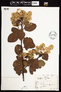 Ceanothus sanguineus Pursh 656531[1057172]Abair, Christopher s.n.1974-06-06 United States, Washington, Thurston, Marvin Road, Thurston Co. |
MIN:Plants | Micranthes subapetala (E.E. Nelson) Small 124907[]Burglehaus, F. s.n.1893-07-00 United States, Wyoming, Park, Yellowstone National Park...near Mammoth Hot springs;Yellowstone National Park, 1829m |
MIN:Plants | Diarrhena obovata (Gleason) Brandenburg 905643[1062808]Lee, Michael United States, Minnesota, Fillmore, Detailed locality information protected. This is typically done to protect rare or threatened species localities. |
MIN:Plants | Rhynchospora capillacea Torrey 472650[1021699]Lee, Michael United States, Minnesota, Stearns, Detailed locality information protected. This is typically done to protect rare or threatened species localities. |
MIN:Plants | 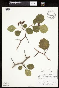 435084[1025694]Lee, Michael MDL19131997-08-13 United States, Minnesota, Stearns, Stearns County...5 miles south of Avon...T124N R30W SW1/4 SE1/4 NE1/4 Sec. 20;;124N;30W;20, 45.53605 -94.47374 |
MIN:Plants |  Salix discolor Muhlenberg 462110[1090512]Smith, Welby 268931998-04-14 United States, Minnesota, Rice, Boyd Wildlife Management Area. Rice County ... Boyd State Wildlife Management Area, about 9 miles W-NW of Faribault ... T 110N R 22W NE1/4 of NE1/4 of Sec 9. 110N 22W 9, 44.3555556 -93.4638889 |
MIN:Plants | Epilobium densiflorum (Lindley) Hoch & P.H. Raven 236985[]Congdon, J. s.n.1885-06-00 United States, California, Mariposa, Snow Creek;Yosemite National Park |
MIN:Plants |  Pellaea glabella Mettenius ex Kuhn 263241[1377804]Sheldon, Edmund s.n.1892-09-00 United States, Wisconsin, Polk, Osceola;Saint Croix National Riverway;;;, 45.237725 -92.438793 |
MIN:Plants | 507638[]Lee, Michael MDL24071998-08-25 United States, Minnesota, Morrison, Camp Ripley Military Reservation. Morrison County ... Camp Ripley National Guard Base. Along Tamarack Lake five miles south-southeast of Pillager ... south side of the lake ... T132N R30W NW1/4 of SE1/4 of SW1/4 Sec. 11. 132N 30W 11, 46.260118 -94.422626 |
MIN:Plants |  909812[1154648]Smith, Welby 246001994-07-11 United States, Minnesota, Koochiching, About 3 mi east of Northome. Tuefer Lake. SW1/4 of NE1/4 of section;;151N;28W;27, 47.8694444 -94.2183333 |
MIN:Plants | Epipactis gigantea Douglas ex Hooker 576655[1310389]Erdman, J. United States, Colorado, Montezuma, Detailed locality information protected. This is typically done to protect rare or threatened species localities. |
MIN:Plants |  905299[1343378]Myhre, K. 099152007-08-09 United States, Minnesota, Clearwater, Itasca State Park. Clearwater County...Whipple Lake...Located 40 miles southeast of the town of Bagley...east shore...T143N R36W SW1/4 of SW1/4 of Sec 27. 143N 36W 27, 47.1677778 -95.2322222 |
MIN:Plants | Ulmus rubra Muhlenberg 462132[]Smith, Welby 290082000-08-18 United States, Minnesota, Wabasha, Dorer Memorial Hardwood State Forest. Wabasha County ... Dorer Memorial Hardwood State Forest. In the Zumbro River Valley about 4 miles N-NW of Kellogg ... T110N R11W SE1/4 of SE1/4 of Sec 12. 110N 11W 12, 44.3397222 -92.0763889 |
MIN:Plants |  Carex eburnea Boott 478126[1010113]Wheeler, Gerald 193371998-06-23 United States, Minnesota, Carver, Carver County ... Ca. 0.5 mi. SSW of East Union of Rte. 40; W of road ... bluff overlooking Bevens Creek ... NE1/4 SE1/4 Sec. 3 T114N R24W (San Francisco 3). 114N 24W 3, 44.710583 -93.694235 |
MIN:Plants |  Carex brunnescens subsp. sphaerostachya (Tuckerman) Kalela 905434[1008089]Gerdes, Lynden 47862003-07-22 United States, Minnesota, Lake, Superior National Forest. T60N R06W S31SWNE. Lake County...Superior National Forest. Lupus Lake area, approx. 10.18 miles ENE of Isabella, MN and 0.15 mile NE of Lupus Lake. 060N 06W 31, 47.637629 -91.139643 |
MIN:Plants |  Potentilla tridentata Aiton 283321[1029494]Butters, F.; Buell, Murray 3521932-07-08 United States, Minnesota, Cook, ...near copper mine. Susie Island, Lake Superior, Cook Co. T63N; R7E.;North Shore / Susie Islands, The Nature Conservancy;063N;07E;05, 47.973776 -89.578978 |
MIN:Plants |  899119[1093741]Smith, Welby 259011995-08-23 United States, Minnesota, Renville, Skalbakken County Park. Renville County...Skalbakken County park...Minnesota River, about 6 miles east of Granite Falls...T115N R38W SE1/4 of SW1/4 of Sec 27. 115N 38W 27, 44.7347222 -95.4169444 |
Google Map
Google Maps is a web mapping service provided by Google that features a map that users can pan (by dragging the mouse) and zoom (by using the mouse wheel). Collection points are displayed as colored markers that when clicked on, displays the full information for that collection. When multiple species are queried (separated by semi-colons), different colored markers denote each individual species.