University of Minnesota
http://www.umn.edu/
612-625-5000
http://www.umn.edu/
612-625-5000
Minnesota Biodiversity Atlas
Bell Museum
Dataset: MIN-Plants
Taxa: Rhamnaceae
Search Criteria: excluding cultivated/captive occurrences
Bell Museum plants | |
 MIN:Plants |  909849[1057404]Smith, Welby 252781994-08-25 United States, Minnesota, Jackson, Kilen Woods State Park. Jackson County...Kilen Woods State Park, about 8 miles north-northwest of Jackson...along a small tributary stream... T 103N R 35W NW1/4 of NE1/4 of Sec 17. 103N 35W 17, 43.7255556 -95.0583333 |
MIN:Plants |  920241[1057338]Smith, Welby 221971993-05-25 United States, Minnesota, Meeker, Meeker County...On the south side of T.H. 12, about 2 miles southeast of Darwin...T119N R30W NW1/4 of SE1/4 of Sec 25;;119N;30W;25, 45.0872222 -94.3916667 |
MIN:Plants |  429070[1057429]Smith, Welby 278621999-06-10 United States, Minnesota, Otter Tail, Inspiration Peak Scenic Wayside Park. Otter Tail County ... Inspiration Peak Wayside Park, about 12 miles west of Parkers Prairie ... T 131N R 39W SE1/4 of SW1/4 of Sec 22. 131N 39W 22, 46.1383324 -95.5736084 |
MIN:Plants |  912461[1057402]Smith, Welby 254001994-09-07 United States, Minnesota, Cass, Cass County...About 0.5 mile north-northeast of Motley...T 133N R 31W SE1/4 of SW1/4 of Sec 7;;133N;31W;07, 46.3508333 -94.6408333 |
MIN:Plants |  913762[1057400]Smith, Welby 243251994-06-10 United States, Minnesota, Dakota, Dakota County... Labanon Hills Regional Park in Eagan... T27N R23W NE1/4 of SE1/4 of Sec 32;Lebanon Hills County Park;027N;23W;32, 44.7808333 -93.19 |
MIN:Plants |  912964[1057343]Smith, Welby 243541994-06-14 United States, Minnesota, Yellow Medicine, Upper Sioux Agency State Park. Yellow Medicine County...Upper Sioux Agency State Park, about 7 miles southwest of Sacred Heart; in the Minnesota River Valley...T 115N R 38W SE1/4 of SE1/4 of Sec 29. 115N 38W 29, 44.735 -95.4425 |
MIN:Plants |  909907[1057403]Smith, Welby 252551994-08-23 United States, Minnesota, Carver, Minnesota Valley State Park. Carver County...Minnesota Valley State Park, about 1.5 miles north-northeast of Belle Plain...T 114N R 24W SW1/4 of SE1/4 of Sec 30. 114N 24W 30, 44.6458333 -93.7541667 |
MIN:Plants |  459905[1057436]Kaul, R.; et al. 71001992-05-17 United States, Minnesota, Steele, Steele County ... along Straight River south of Morehouse Park. [Owatonna];;107N;20W;, 44.06611 -93.22607 |
MIN:Plants | 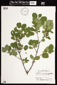 896644[1057391]Smith, Welby 293362002-08-05 United States, Minnesota, Traverse, Traverse County...Near where Hwy 117 crosses Lake Traverse from Minnesota into South Dakota...T 127N R 47W SW1/4 of NW1/4 of Sec 32. 127N 47W 32, 45.76702 -96.60408 |
MIN:Plants |  918205[1057336]Smith, Welby 224401993-06-18 United States, Minnesota, Grant, Grant County ... On the south side of Ask Lake, about 1.5 miles east-southeast of Ashby ...T130N R41W NW1/4 of SW1/4 of Sec 12. 130N 41W 12, 46.0847222 -95.7886111 |
MIN:Plants | 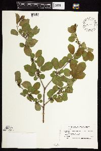 453851[1057438]Smith, Welby 166141990-05-17 United States, Minnesota, Steele, Waseca County...Wayside rest at I35 crossing of Straight River [this is Steele Co. not Waseca]... T 106N R 20W NE1/4 of SW1/4 of Sec 17. 106N 20W 17, 43.9852791 -93.2574997 |
MIN:Plants | 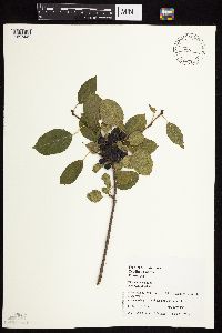 493328[1057442]Juhnke, C. 056 CMJ FRO1998-08-27 United States, Minnesota, Goodhue, Frontenac State Park. Goodhue County ... main park road ... T 112N R 13W NW NW SW 2;Frontenac State Park;112N;13W;02, 44.49871 -92.36985 |
MIN:Plants | 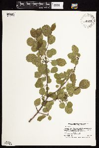 920272[1057339]Smith, Welby 222271993-05-25 United States, Minnesota, McLeod, Lake Marion County Park. McLeod County...Lake Marion County Park; on the east side of Lake Marion, about 6 miles south of Hutchinson...T115N R 30W NE1/4 of NE1/4 of Sec 12. 115N 30W 12, 44.7877778 -94.3811111 |
MIN:Plants |  461615[1057352]Schik, K. 96-61996-05-30 United States, Minnesota, Wilkin, Wilkin Co, T136N R48W SW1/4 of the SW1/4 of S17; along the Red River;;136N;48W;17, 46.59462 -96.74957 |
MIN:Plants |  899522[1057368]Smith, Welby 275831998-09-08 United States, Minnesota, Stearns, About 2 miles southwest of St. Cloud. NW1/4 of NW1/4 of Sec.;Quarry Park Nature Preserve & Scientific Natural Area;124N;28W;29, 45.5283333 -94.2352778 |
MIN:Plants |  511229[1057433]Wheeler, Gerald 195671999-05-16 United States, Minnesota, Murray, Murray County ... Ca. 2.5 mi. NW of Currie; Lake Shetek State Park ... S1/2 Sec. 6 T107N R40W (Murray 6);Lake Shetek State Park;107N;40W;6, 44.10183 -95.6934 |
MIN:Plants |  914646[1057340]Smith, Welby 225591993-06-22 United States, Minnesota, Stevens, Hornings Pit Wildlife Management Area. Stevens County...Horning's Pit State Wildlife Management Area, about 10 miles west-northwest of Donnelly...T 126N R 44W SW1/4 of NE1/4 of Sec 18. 126N 44W 18, 45.7244444 -96.2433333 |
MIN:Plants |  477776[1057431]Smith, Welby 171101990-06-28 United States, Minnesota, Waseca, Waseca County ... At the north end of Buffalo Lake, about 3 miles south of Janesville ... T 107N R 24W NE1/4 of NE1/4 of Sec 20. 107N 24W 20, 44.065834 -93.7300034 |
MIN:Plants |  913798[1057399]Smith, Welby 243441994-06-14 United States, Minnesota, Lyon, Lyon County... Camden State Park, about 3 miles N-NE of Russell... T110N R42W NE1/5 of SW1/4 of Sec 5;Camden State Park;110N;42W;05, 44.36 -95.9294444 |
MIN:Plants |  923373[1057412]Smith, Welby 201411992-05-12 United States, Minnesota, Le Sueur, About 2 miles east of Waterville. NW1/4 of NE1/4 of section;Sakatah Lake State Park;109N;23W;25, 44.2241667 -93.5294444 |
MIN:Plants |  922483[1127447]Smith, Welby 234651993-08-10 United States, Minnesota, Cottonwood, About 6 miles north-northwest of Storden, along Dutch Charley Creek. SW1/4 of NE1/4 of Sec;;108N;38W;36, 44.1194444 -95.3513889 |
MIN:Plants |  921060[1127445]Smith, Welby 248701994-07-20 United States, Minnesota, Lincoln, On the west side of Lake Benton ... T109N R45W NE1/4 of NE1/4 of Sec 4;;109N;45W;04, 44.2844444 -96.2647222 |
MIN:Plants |  923059[1127444]Smith, Welby 238831993-09-09 United States, Minnesota, Meeker, About 3/4 mile west of Cosmos...right-of-way of the C & NW Railroad (abandoned)...T 117N R 32W SW1/4 of SW1/4 of Sec 16. 117N 32W 16, 44.9369444 -94.7138889 |
MIN:Plants |  920455[1127434]Smith, Welby 238971993-09-09 United States, Minnesota, Meeker, About one mile east-southeast of Cedar Mills...along the C & NW Railroad right-of-way (now abandoned)...T 117N R 31W SE1/4 of SE1/4 of Sec 13. 117N 31W 13, 44.9394444 -94.5036111 |
MIN:Plants |  922579[1127436]Smith, Welby 233741993-08-04 United States, Minnesota, Olmsted, About 3.5 miles northeast of Marion, along Bear Creek. SE1/4 of NE1/4 of Sec;Chester Woods County Park;106N;13W;13, 43.9875 -92.3194444 |
MIN:Plants |  922149[1127446]Smith, Welby 232671993-08-03 United States, Minnesota, Renville, in the Minnesota Valley about 4 miles southwest of Sacred Heart. SW1/4 of SE1/4 of Sec;Skalbakken County Park;115N;38W;27, 44.7338889 -95.4097222 |
MIN:Plants |  921925[1127437]Smith, Welby 233961993-08-04 United States, Minnesota, Wabasha, Carley State Park, about 3 miles south of Plainview...T 108N R 11W NW1/4 of NE1/4 of Sec 32;Carley State Park;108N;11W;32, 44.1194444 -92.175 |
MIN:Plants |  921941[1127443]Smith, Welby 250011994-08-02 United States, Minnesota, Wadena, About 2 miles south of Sebeka.. NW1/4 of NE1/4 of Sec ;;136N;35W;15, 46.5994444 -95.0825 |
MIN:Plants |  922784[1127442]Smith, Welby 239961993-09-21 United States, Minnesota, Winona, About 3 miles west of Winona...T 107N R 8W NE1/4 of NW1/4 of Sec 24;;107N;08W;24, 44.0622222 -91.7313889 |
MIN:Plants |  929737[1127440]Smith, Welby 161381989-08-20 United States, Minnesota, Le Sueur, Minnesota Valley, about 1.5 miles south of Ottawa. NW of SE of section;Ottawa Bluffs, The Nature Conservancy;110N;26W;03, 44.3625 -93.9363889 |
MIN:Plants |  930969[1127441]Smith, Welby R. 160121989-07-31 United States, Minnesota, Kanabec, On the west side of Mora, along Snake River. NE1/4 of SE1/4 of section;;T039N R24W S10, 45.882975 -93.310658 |
MIN:Plants |  931681[1127433]Smith, Welby R. 202611992-05-21 United States, Minnesota, Polk, On the north side of Maple Lake, about 2 miles south of Mentor NW of SE of section;;148N;43W;05, 47.6638889 -96.1563889 |
MIN:Plants |  933500[1127435]Smith, Welby R. 205291992-06-24 United States, Minnesota, Brown, On the south side of New Ulm in the Cottonwood River Valley NW of SE of section;Flandrau State Park;110N;30W;32, 44.2875 -94.4608333 |
MIN:Plants |  934391[1127432]Smith, Welby R. 216261992-08-26 United States, Minnesota, Nicollet, about 7 miles north of Mankato. NW1/4 of NE1/4 of section;Seven Mile Creek County Park;109N;27W;11, 44.2680556 -94.0344444 |
MIN:Plants |  934932[1127439]Whitfeld, T. J. S.; et al. 7562011-08-30 United States, Minnesota, Dakota, Hyland Park, Dakota County;;;;, 44.68 -93.06 |
MIN:Plants |  935377[1127438]Smith, Welby R. 332892011-08-05 United States, Minnesota, Polk, About 2 miles north of the town of Gully. SE1/4 of SE1/4 of section;Larix State Wildlife Management Area;150N;39W;22, 47.7925 -95.6252778 |
MIN:Plants |  98292[1127431]Smith, Welby R. 320652010-08-27 United States, Minnesota, Saint Louis, About 0.5 mile east of Kitzville. NW of NE of section;;057N;20W;04, 47.4509351 -92.8787085 |
MIN:Plants |  942286[1283363]Gerdes, Lynden B. 69752013-11-06 United States, Minnesota, Lake, Slate Lake Area Approximately 14.58 miles NW of Isabella, MN and 0.08 miles west off Hwy. 1 on north side of woods road. NESE of section;Superior National Forest;60N;10W;07, 47.765714 -91.571377 |
MIN:Plants |  944864[1283346]Nee, M. 611752014-06-09 United States, Wisconsin, Polk, Interstate [State] Park, St. Croix Falls. North campground, just N of the Hwy. 8 causeway and E of the St. Croix River. T34N, R18W, sect. 30, 45.402778 -92.597778, 225m |
MIN:Plants |  529835[1283015]Nee, M. 623962015-07-22 United States, Wisconsin, Grant, Across the Mississipi River from the north edge of Dubuque, Iowa. Around O'Leary Lake Landing on the Mississippi River at the Wisconsin end of Lock and Dam no. 11. T1N; R2W; sect.7, 43.539167 -90.638889, 195m |
MIN:Plants |  949935[1283609]Nee, M. 621892015-05-28 United States, Wisconsin, Richland, 3.8km E of Gotham. T9N R2E SE1/4 SW1/4 Sect. 27, 43.219167 -90.245, 228m |
MIN:Plants |  948700[1283014]Whitfeld, T. J. S. 10762014-08-15 United States, Rhode Island, Washington, 2.3 miles west north west of the intersection between Mail Road and Route 2 (South County Trail); 3.5 miles southwest of Exeter., 41.541356 -71.590158 |
MIN:Plants |  959339[1311181]Lynden B. Gerdes 72302015-06-16 United States, Minnesota, Koochiching, Approximately 7.23 miles ESE of Littlefork, MN and 1.65 miles west of the Galvin Road. North side of the Beaver Brook River., 48.36194444 -93.40222222 |
MIN:Plants |  960587[1329188]Lee, Michael MDL33302002-09-18 United States, Minnesota, Carlton, Along the lower reaches of Otter Creek in fairly rugged bedrock terrain south of the Thomson Reservoir, ~halfway between Carlton and Thomson; ~1/4-mile upstream from the St. Louis River. N1/2 of NE1/4 of NE1/4 Sec. 7, Jay Cooke State Park, 46.659252 -92.418536 |
MIN:Plants |  966328[1359167]T. J. S. Whitfeld 25372020-06-09 United States, Minnesota, Washington, Lost Valley Prairie Scientific and Natural Area, 2 miles east north east of intersection of State Highway 95 and 110th Street, at dead-end of Nyberg Avenue South., 44.799732 -92.825834, 274m |
MIN:Plants |  967085[1359777]Rowe, Erika R. ERR5482009-07-25 United States, Minnesota, Beltrami, Approximately 15 meters southwest of Nelson Dam Rd.; 1.65 miles northwest of Pinewood., 47.61 -95.16 |
MIN:Plants |  968124[1368723]Brett Dunlavey 412016-09-30 United States, Rhode Island, Providence, Scott Brook Preserve, off Scott Road, 0.3 miles north of Interstate 295., 41.9560778 -71.4289639 |
MIN:Plants |  968262[1368842]Meghan N. Hershkowitz 112017-09-15 United States, Rhode Island, Providence, Lime Rock Preserve, east parcel off Sherman Avenue, 1/4 mile east of Route 146., 41.91715 -71.45248, 65m |
MIN:Plants | []Timothy J. S. Whitfeld 31892022-06-03 United States, Minnesota, Washington, Crystal Spring Scientific and Natural Area, 0.4 miles northeast of the intersection of Scandia Trail North and Hwy 95, 45.2598969 -92.764188, 250m |
MIN:Plants |  971178[1394651]Nee, M.H. 651002019-07-06 United States, Wisconsin, Vernon, 6 km. WSW of Viroqua; north arm of Sidie Hollow Lake., 43.538889 -90.959722, 290 - 320m |
MIN:Plants |  971278[1394755]M. H. Nee 661032020-07-28 United States, Wisconsin, Sauk, 2.2 km SSE of center of Spring Green. Floodplain of Wisconsin River, along and beside long abandoned causeway of the old stretch of road from the Wisconsin River bridge to Spring Green. T 8 N; R 4 E; SE¼NW¼ sect. 19., 43.155556 -90.065, 214m |
MIN:Plants |  971277[1394754]M. H. Nee 657912020-06-20 United States, Wisconsin, Grant, 2.8 km NW of center of Lancaster, trailhead for the “Lancaster Trail”, along Hwy. K. T 5 N; R 3 W; NW¼NW¼ sect. 34., 42.871111 -90.723333, 290m |
MIN:Plants |  971274[1394751]M. H. Nee 675282021-08-25 United States, Wisconsin, Trempealeau, 4km SW of Blair, Lakes Coulee State Wildlife Area, vic. parking area off Elias Road., 44.275556 -91.279722, 270m |
MIN:Plants |  971272[1394749]M. H. Nee 665672020-09-16 United States, Wisconsin, Buffalo, 1.7 km SW of Cochrane, Spring Lake boat landing on Mississippi River. T 20 N; R 12 W; NW¼NW¼ sect. 17., 44.214444 -91.849444 |
MIN:Plants |  971271[1394748]M. H. Nee 664602020-09-15 United States, Wisconsin, Buffalo, Boat landing on S side of Hwy. 35 bridge over the Chippewa River. T 23 N; R 14 W; NW¼NW¼ sect. 34, 44.436944 -92.071667, 206m |
MIN:Plants |  971270[1394747]M. H. Nee 664462020-09-15 United States, Wisconsin, Buffalo, Indian Slough of the Mississippi River, boat landing on E side of the main Hwy. 25 bridge, opposite Waubasha, Minnesota. T 22 N; R 13 W; SE¼NW¼ sect. 13., 44.389722 -92.028333, 204m |
MIN:Plants |  971246[1394723]M. H. Nee 665092020-09-16 United States, Wisconsin, Pepin, 1.8 km SE of Stockholm, between Hwy. 35 and the railroad, SE of junction with Hwy. JJ. T 23 N; R 15 W; NW¼SE¼ sect. 18., 44.475 -92.241944, 220m |
MIN:Plants | []Gernes, Mark 2022-06-13 United States, Minnesota, Kandiyohi, Lindgren Lake Wildlife Protection Area; Site ID: 16KAND298; Visit Number: 2634, 45.17108464 -95.13512888 |
MIN:Plants |  974248[1396612]Smith, Welby R WRS364732019-08-17 United States, Minnesota, Dakota, Spring Lake Regional Park, about 10.4 km (6.5 miles) west of the Mississippi River Bridge in Hastings., 44.757208 -92.982797 |
MIN:Plants | []J. C. B. Waddington 811966-06-01 United States, Minnesota, Hennepin, east shore of Cedar Lake and Burnham Rd; 44.957853 -93.317385, 44.957853 -93.317385 |
MIN:Plants | []Lyndon Scott Fluegel 12023-11-09 United States, Minnesota, Le sueur, Sakatah Lake State Park, 0.44 miles from visitors center on main road after crossing Oak Tree Trail and before Sakatah Singing Hills State Trail., 44.224318 -93.224318 |
MIN:Plants |  Rhamnus crocea Nuttall 238649[1127450]Congdon, J. s.n.1883-07-00 United States, California, Mariposa, Mormon Bar;Yosemite National Park;;;, 37.46222 -119.94694 |
MIN:Plants |  Rhamnus crocea Nuttall 238645[1127451]Congdon, J. s.n.1894-05-12 United States, California, Mariposa, Snow Creek;Yosemite National Park |
MIN:Plants |  Rhamnus crocea Nuttall 238414[1127449]Congdon, J. s.n.1883-07-00 United States, California, Mariposa, Mormon Bar;Yosemite National Park;;;, 37.46222 -119.94694 |
MIN:Plants | Rhamnus crocea Nuttall 511308[]Univ. of Calif. Bot. Gard. list 17 - 811974-00-00 United States, California, Contra Costa, Contra Costa Co. |
MIN:Plants |  Rhamnus crocea Nuttall 238417[1127448]Congdon, J. s.n.1885-09-06 United States, California, Mariposa, Devil's Gulch, Mariposa County;Yosemite National Park |
MIN:Plants | Frangula californica subsp. californica (Eschscholtz) A. Gray 511310[]Univ. of Calif. Bot. Gard. list 17 - 801974-00-00 United States, [no data] |
MIN:Plants |  Frangula rubra subsp. obtusissima (Greene) Grubov 794657[1057176]Schaaf, J. 2511982-08-14 United States, Nevada, Washoe, Washoe Valley, Davis Creek;;;;, 39.26972 -119.80417, 1524m |
MIN:Plants |  938130[1226724]Ahart, L. 6311 United States, California, Butte |
MIN:Plants |  Ceanothus americanus var. pitcheri Torrey & A. Gray 913894[1057020]Smith, Welby 228051993-07-12 United States, Minnesota, Freeborn, Between CSAH 46 and the Soo Line Railroad tracks, about 8 miles east of Albert Lea. NW1/4 of SW1/4 of ssection;;T102N R20W S01, 43.666432 -93.179093 |
MIN:Plants |  Ceanothus americanus var. pitcheri Torrey & A. Gray 488918[1056994]Juhnke, C. 439 CMJ FRO1999-07-13 United States, Minnesota, Goodhue, Frontenac State Park Goodhue County ... Near railroad tracks south of Hwy. 61 ... T112N R13W SW SW NE 14;Frontenac State Park;112N;13W;14, 44.50549 -92.3394 |
MIN:Plants |  Ceanothus americanus var. pitcheri Torrey & A. Gray 508758[1056995]Smith, Welby 263281990-08-12 United States, Minnesota, Mower, Mower County ... Lake louise State Park, about 2 miles NW of LeRoy ... T101N R14W NW!/4 of NW1/4 of Sec 28;Lake Louise State Park;101N;14W;28, 43.5272217 -92.5238876 |
MIN:Plants |  Ceanothus americanus var. pitcheri Torrey & A. Gray 905235[1056999]Smith, Welby; Lee, Michael 294692004-07-16 United States, Minnesota, Todd, About 4 miles east of Grey Eagle. NE1/4 of SE1/4 of section;;127N;32W;11, 45.8216667 -94.6686111 |
MIN:Plants |  Ceanothus americanus var. pitcheri Torrey & A. Gray 918712[1056998]Anderson, Derek 9362008-06-30 United States, Minnesota, Mower, Mower County...Ca 1km west of Rose Creek along Highway 56 right-of-way...T102N R17W NWSW26;;102N;17W;26, 43.6086111 -92.8447222 |
MIN:Plants |  Ceanothus americanus var. pitcheri Torrey & A. Gray 910131[1057001]Anderson, Derek 10312008-08-27 United States, Minnesota, Dodge, Dodge County...T106N, R16W, NWSW35...about 6 km northeast of Oslo;;106N;16W;35, 43.9408333 -92.7127778 |
MIN:Plants |  Ceanothus americanus var. pitcheri Torrey & A. Gray 435047[1057051]Belanger, W. 13161999-06-11 United States, Minnesota, Sherburne, [transect] FQURU1-01. SE1/4 NW1/4 of section;Sherburne National Wildlife Refuge;035N;27W;22, 45.5086554 -93.6853294 |
MIN:Plants |  Ceanothus americanus var. pitcheri Torrey & A. Gray 440778[1057052]Smith, Welby 138611987-08-14 United States, Minnesota, Washington, About 2 mi south of St. Paul Park. NW1/4 SE1/4 of section;;027N;21W;30, 44.795 -92.9683333 |
MIN:Plants |  Ceanothus americanus var. pitcheri Torrey & A. Gray 834914[1056991]Cholewa, A.; Engels, A. 23291995-07-07 United States, Minnesota, Aitkin, SW of Savanna Portage State Park entrance, about 17 mi NE of McGregor. About center of section;Savanna State Forest;050N;23W;26, 46.7884 -93.22244 |
MIN:Plants |  Ceanothus americanus var. pitcheri Torrey & A. Gray 151759[1057018]Rosendahl, C. 22711909-07-10 United States, Minnesota, Near bottom of slope, Ft. Snelling Reservation [old regional park spanning junction of Minnesota and Mississippi rivers;;028N;23W;, 44.90516 -93.16646 |
MIN:Plants |  Ceanothus americanus var. pitcheri Torrey & A. Gray 151760[1127415]Aiton, G. 27-31890-06-00 United States, Minnesota, Hennepin, [no further data];;;;, 45 -93.47 |
MIN:Plants |  Ceanothus americanus var. pitcheri Torrey & A. Gray 151761[1057019]Manning, Sara; Moyer, Lycurgus s.n.1898-06-27 United States, Minnesota, Wabasha, Lake City;;111N;12W;, 44.4081 -92.25245 |
MIN:Plants |  Ceanothus americanus var. pitcheri Torrey & A. Gray 151762[1057088]Moyer, Lycurgus s.n.1906-08-07 United States, Minnesota, Otter Tail, Leaf Mountain;;;;, 46.1511 -95.5928 |
MIN:Plants |  Ceanothus americanus var. pitcheri Torrey & A. Gray 151763[1057046]Bergman, H. 28961913-07-27 United States, Minnesota, Crow Wing, [Lake] Hubert;;135N;28W;, 46.50045 -94.20366 |
MIN:Plants |  Ceanothus americanus var. pitcheri Torrey & A. Gray 151764[1057072]Manning, Sara s.n.1883-07-19 United States, Minnesota, Wabasha, Lake City;;111N;12W;, 44.4081 -92.25245 |
MIN:Plants |  Ceanothus americanus var. pitcheri Torrey & A. Gray 151765[1057014]Ballard, C. B5661891-07-00 United States, Minnesota, Scott, Prior Lake;;;;, 44.71333 -93.4225 |
MIN:Plants |  Ceanothus americanus var. pitcheri Torrey & A. Gray 151766[1057073]Manning, Sara s.n.1892-07-23 United States, Minnesota, Wabasha, Lake City;;111N;12W;, 44.4081 -92.25245 |
MIN:Plants |  Ceanothus americanus var. pitcheri Torrey & A. Gray 151767[1057045]Bergman, H. 28961913-07-27 United States, Minnesota, Crow Wing, [Lake] Hubert;;135N;28W;, 46.50045 -94.20366 |
MIN:Plants |  Ceanothus americanus var. pitcheri Torrey & A. Gray 151768[1057012]Sandstein, E. s.n.1891-07-00 United States, Minnesota, Ramsey, St. Anthony Park [St. Paul neighborhood near U of M];;029N;23W;, 44.99208 -93.16639 |
MIN:Plants |  Ceanothus americanus var. pitcheri Torrey & A. Gray 151769[1057048]Ballard, C. B10631892-07-00 United States, Minnesota, Nicollet, Oshawa, Nicollet Co.;;110N;27W;, 44.32639 -94.06967 |
MIN:Plants |  Ceanothus americanus var. pitcheri Torrey & A. Gray 151770[1057086]Kassube, J. s.n.1878-07-00 United States, Minnesota, Hennepin, Rocky Lake;;;;, 45 -93.47 |
MIN:Plants |  Ceanothus americanus var. pitcheri Torrey & A. Gray 151771[1127418]Aiton, G. s.n.1889-07-00 United States, Minnesota, Hennepin, [no further data];;;;, 45 -93.47 |
MIN:Plants |  Ceanothus americanus var. pitcheri Torrey & A. Gray 151772[1057079]Manning, Sara 2961884-06-28 United States, Minnesota, Wabasha, Lake City;;111N;12W;, 44.4081 -92.25245 |
MIN:Plants |  Ceanothus americanus var. pitcheri Torrey & A. Gray 151773[1057015]Sheldon, Edmund S9311891-07-00 United States, Minnesota, Redwood, Redwood Falls;;;;, 44.53944 -95.11667 |
MIN:Plants |  Ceanothus americanus var. pitcheri Torrey & A. Gray 151774[1057057]Holzinger, John s.n.1888-09-15 United States, Minnesota, Winona, Winona;;;;, 44.05 -91.63917 |
MIN:Plants |  Ceanothus americanus var. pitcheri Torrey & A. Gray 151775[1057090]Ballard, C. B4651891-07-00 United States, Minnesota, Scott, Prior Lake;;;;, 44.71333 -93.4225 |
MIN:Plants |  Ceanothus americanus var. pitcheri Torrey & A. Gray 151776[1057080]Sheldon, Edmund S11711891-07-00 United States, Minnesota, Brown, New Ulm;;110N;30W;, 44.32636 -94.4318 |
MIN:Plants |  Ceanothus americanus var. pitcheri Torrey & A. Gray 151777[1057087]Ballard, C. B7401891-07-00 United States, Minnesota, Carver, Waconia;;116N;25W;, 44.8476 -93.82775 |
MIN:Plants |  Ceanothus americanus var. pitcheri Torrey & A. Gray 151778[1057078]Sheldon, Edmund S31771892-07-00 United States, Minnesota, Kanabec, Mora;;039N;24W;, 45.86068 -93.32753 |
MIN:Plants |  Ceanothus americanus var. pitcheri Torrey & A. Gray 151779[1057077]Wheeler, William 3561899-07-15 United States, Minnesota, Houston, Crooked Creek;Dorer Memorial Hardwood State Forest;;;, 43.57333 -91.26833 |
MIN:Plants |  Ceanothus americanus var. pitcheri Torrey & A. Gray 151780[1127413]Sandberg, John s.n.1889-07-00 United States, Minnesota, Hennepin, [no further data];;;;, 45 -93.47 |
Google Map
Google Maps is a web mapping service provided by Google that features a map that users can pan (by dragging the mouse) and zoom (by using the mouse wheel). Collection points are displayed as colored markers that when clicked on, displays the full information for that collection. When multiple species are queried (separated by semi-colons), different colored markers denote each individual species.