University of Minnesota
http://www.umn.edu/
612-625-5000
http://www.umn.edu/
612-625-5000
Minnesota Biodiversity Atlas
Bell Museum
Dataset: MIN-Plants
Taxa: Amaranthaceae
Search Criteria: excluding cultivated/captive occurrences
Bell Museum plants | |
 MIN:Plants | Froelichia floridana (Nuttall) Moquin-Tandon 264087[]Holzinger, John s.n.1901-08-00 United States, Minnesota, Hennepin, Near Minneapolis;;N;;, 44.98 -93.26361 |
MIN:Plants | Froelichia floridana (Nuttall) Moquin-Tandon 264168[]Holzinger, John s.n.1896-08-00 United States, Minnesota, Hennepin, Near Fort Snelling [assuming Hennepin Co.];;028N;23W;, 44.905162 -93.166462 |
MIN:Plants | Froelichia floridana (Nuttall) Moquin-Tandon 277722[]Roberts, Thomas s.n.1877-08-13 United States, Minnesota, Hennepin, Minneapolis;;N;;, 44.979965 -93.263836 |
MIN:Plants | Froelichia floridana (Nuttall) Moquin-Tandon 306877[]Cottrell, R. s.n.1985-08-20 United States, Minnesota, Anoka, Fridley Dunes.;;030N;24W;, 45.080985 -93.255535 |
MIN:Plants | Froelichia floridana (Nuttall) Moquin-Tandon 352993[]Jukkola, E. 851937-07-17 United States, Minnesota, Anoka, Moore Lake.;;030N;24W;, 45.080985 -93.255535 |
MIN:Plants |  Froelichia floridana (Nuttall) Moquin-Tandon 383565[]Moore, John 159201943-08-18 United States, Minnesota, Dakota, Four Corners. Dakota Co.;;113N;17W;9, 44.608302 -92.863172 |
MIN:Plants | Froelichia floridana (Nuttall) Moquin-Tandon 440560[]Smith, Welby 149561988-08-23 United States, Minnesota, Winona, Winona Co. About 5 mi N-NE of Peterson; NE1/4 SE1/4 sec.33, T105N R8W;Dorer Memorial Hardwood State Forest;105N;08W;33, 43.854118 -91.789546 |
MIN:Plants | Froelichia floridana (Nuttall) Moquin-Tandon 442085[]Moore, John; Dahl, A. 182511945-09-21 United States, Minnesota, Wabasha, 1/2 mi. S, 1 mi. E of Ireland Station below Wabasha.;;N;;, 44.376614 -92.032945 |
MIN:Plants | Froelichia floridana (Nuttall) Moquin-Tandon 459480[]Smith, Welby 164001989-09-06 United States, Minnesota, Benton, Benton Co. On the E bank of the Mississippi River in Rice; NE1/4 NE1/4 sec.36, T38N R32W;;038N;32W;36, 45.748333 -94.2600021 |
MIN:Plants | Froelichia floridana (Nuttall) Moquin-Tandon 568604[]Moore, John 249031959-09-29 United States, Minnesota, Blue Earth, 2 mi. W of Mankato.;;N;;, 44.16357 -94.03978 |
MIN:Plants | Froelichia floridana (Nuttall) Moquin-Tandon 603644[]Moore, John 270271966-10-17 United States, Minnesota, Anoka, W of Fish Lake, Cedar Creek Natural History Area.;Cedar Creek National History Area;034N;23W;, 45.428063 -93.203997 |
MIN:Plants | Froelichia floridana (Nuttall) Moquin-Tandon 635007[]Lindayen, T. 1861972-09-02 United States, Minnesota, Washington, Washington Co.; T27N, R21W, SW1/4 Sec. 26, 1 mi. due S of Hwy. 61. Ca. 100 ft. away from the road.;;027N;21W;26, 44.797346 -92.893437 |
MIN:Plants | Froelichia floridana (Nuttall) Moquin-Tandon 704567[]Smith, Welby 16171979-08-16 United States, Minnesota, Wabasha, T109N, R09W, NE1/4 NE1/4 Sec. 19. 1.6 km due E of Hwy. 61.;;109N;09W;19, 44.229186 -91.93937 |
MIN:Plants | Froelichia floridana (Nuttall) Moquin-Tandon 706841[]Peterson, Jon 891979-10-06 United States, Minnesota, Houston, Houston Co. T103, R05W, NW1/4 NE1/4 Sec. 2. Ca. 3 mi. W of Hokah, on Hwy. 16.;;103N;05W;2, 43.75334 -91.402598 |
MIN:Plants | Froelichia floridana (Nuttall) Moquin-Tandon 709860[]Wheeler, Gerald 48771979-09-08 United States, Minnesota, Scott, Scott Co. Approx. 1.5 mi W of Savage; just W of Rt. 13. T115N, R21W, Sec. 18.;;115N;21W;18, 44.768182 -93.388793 |
MIN:Plants | Froelichia floridana (Nuttall) Moquin-Tandon 711711[]Smith, Welby 17881979-09-08 United States, Minnesota, Scott, Scott Co. T115N, R21W; E1/2 NE1/4 Sec. 18. 0.2 mi. W of Hwy. 13, ca. 0.5 mi. S of the jct. with Hwy. 101.;;115N;21W;18, 44.768182 -93.388793 |
MIN:Plants | Froelichia floridana (Nuttall) Moquin-Tandon 724210[]Smith, Welby 33151980-08-15 United States, Minnesota, Winona, Winona Co. T108N, R10W, NE1/4 NW1/4 SW1/4 Sec. 14. Ca. 1/2 mi. NE of Co. Rd. 30 along a dirt road.;Whitewater Wildlife Management Area;108N;10W;14, 44.15652 -91.990286 |
MIN:Plants | Froelichia floridana (Nuttall) Moquin-Tandon 732756[]Heidel, B. 1031981-08-02 United States, Minnesota, Winona, Whitewater Wildlife Management Area. Near Beaver Junction.;Whitewater Wildlife Management Area;N;;, 44.061594 -92.045857 |
MIN:Plants | Froelichia floridana (Nuttall) Moquin-Tandon 745535[]Smith, Welby 47251981-07-10 United States, Minnesota, Sherburne, On the W side of Hwy. 1, ca. 3 1/2 mi. NNW of its jct. with Hwy. 10 in Elk River. SW1/4 SW1/4 Sec. 17, T33N, R26W.;;033N;26W;17, 45.350221 -93.602608 |
MIN:Plants | Froelichia floridana (Nuttall) Moquin-Tandon 747142[]Galatowitsch, S. 6021982-08-12 United States, Minnesota, Wabasha, Wabasha County...Weaver Dunes...NE1/4 NE1/4 Sec. 6.;Kellogg-Weaver Dunes Scientific Natural Area / Kellogg-Weaver Dunes, The Nature Conservancy;109N;09W;06, 44.272608 -91.938983 |
MIN:Plants | Froelichia floridana (Nuttall) Moquin-Tandon 758596[]Smith, Welby 68661982-07-24 United States, Minnesota, Fillmore, Fillmore Co. In the Root River Valley, about 1 3/4 mi E of Peterson. SW1/4 SW1/4 Sec. 21, T104N, R08W.;Rushford Sand Barrens Scientific Natural Area;104N;08W;21, 43.79616 -91.800172 |
MIN:Plants | Froelichia floridana (Nuttall) Moquin-Tandon 770224[]Smith, Welby 86951983-08-16 United States, Minnesota, Wabasha, Kellogg-Weaver Dunes Scientific Natural Area / Kellogg-Weaver Dunes, The Nature Conservancy. Kellogg-Weaver Dunes State Scientific and Natural Area. Ca. 4 mi. SE of Kellogg, on the E side of Co. Rd. 84. SE1/4 NW Kellogg-Weaver Dunes State Scientific and Natural Area. Ca. 4 mi. SE of Kellogg, on the E side of Co. Rd. 84. SE1/4 NW1/4 Sec. 6, T109N, R09W.. 109N 09W 6, 44.272608 -91.938983 |
MIN:Plants | Froelichia floridana (Nuttall) Moquin-Tandon 776283[]Morley, T. 16261985-07-04 United States, Minnesota, Scott, Scott Co. NNW of Jordan near the Minnesota River. T114N, R24W, SE corner of Sec. 12, N of N loop of E Sioux Vista Drive Scott Co. NNW of Jordan near the Minnesota River. T114N, R24W, SE corner of Sec. 12, N of N loop of E Sioux Vista Drive.. 114N 24W 12, 44.691524 -93.654586 |
MIN:Plants | Froelichia floridana (Nuttall) Moquin-Tandon 787247[]Smith, Welby 110481985-08-10 United States, Minnesota, Dakota, Dakota Co. About 2 mi SSE of Coates. 0.2 mi SW of the jct. of 180th St. and Hwy. 52. NW1/4 NE1/4 Sec. 18, T114N, R18W. Dakota Co. About 2 mi SSE of Coates. 0.2 mi SW of the jct. of 180th St. and Hwy. 52. NW1/4 NE1/4 Sec. 18, T114N, R18W. 114N 18W 18, 44.685833 -93.0222244 |
MIN:Plants | Froelichia floridana (Nuttall) Moquin-Tandon 802908[]Smith, Welby 121881986-07-20 United States, Minnesota, Sherburne, Sherburne National Wildlife Refuge, ca. 2 1/2 mi. SE of Orrock. SW1/4 SE1/4 Sec. 10, T34N, R27W;Sherburne National Wildlife Refuge;034N;27W;10, 45.4444427 -93.6819458 |
MIN:Plants | Froelichia floridana (Nuttall) Moquin-Tandon 816476[]Ownbey, Gerald 73411990-07-21 United States, Minnesota, Washington, Washington Co.; T 127N [should be T27N] R22W, Sec. 25, NW1/4. Newport. W-facing bluff of the Mississippi River.;;027N;22W;25, 44.797303 -92.993814 |
MIN:Plants | Froelichia floridana (Nuttall) Moquin-Tandon 832176[]Morley, T. 17301992-08-16 United States, Minnesota, Dakota, Dakota Co.; ridge running N-S, 2 mi SE of Hastings, S of highway 316. T114N, R17W, W1/4 SE1/4 sec.11;;114N;17W;11, 44.69499 -92.822836 |
MIN:Plants | Froelichia floridana (Nuttall) Moquin-Tandon 269162[]Fassett, N. 59321927-08-21 United States, Wisconsin, Eau Claire, La Crosse Co....West edge of Onalaska Terrace, Onalaska;Upper Mississippi National Wildlife Refuge |
MIN:Plants | Froelichia floridana (Nuttall) Moquin-Tandon 238057[]Partch, M. s.n.1977-09-09 United States, Minnesota, Benton, Langola Township. NE side of Little Rock Lake. ;<No data>;038N;31W;35, 45.74295 -94.164024 |
MIN:Plants | Froelichia floridana (Nuttall) Moquin-Tandon 934269[]Partch, M. s.n.1956-09-09 United States, Minnesota, Benton, Watab Township. Rice Prairie near Rice.;<No data>;037N;31W;3, 45.727893 -94.184923 |
MIN:Plants |  Froelichia floridana (Nuttall) Moquin-Tandon 945902[1291562]Smith, Welby R. WRS348212013-08-29 United States, Minnesota, Sherburne, About 4 km (2.5 miles) northwest of the approximate center of Elk River (town). NE of NE of section; T033N R26W sec19, 45.34225 -93.6145333 |
MIN:Plants |  Grayia spinosa (Hooker) Moquin-Tandon 794895[1037528]Schaaf, J. 261982-07-08 United States, Nevada, Carson City, Carson City Co. ... Prison Hill, 1554m |
MIN:Plants | Grayia spinosa (Hooker) Moquin-Tandon 454116[]Davis, Owen s.n.1978-08-25 United States, Idaho, Butte, Butte Co. |
MIN:Plants |  Grayia spinosa (Hooker) Moquin-Tandon 104984[1037529]Moyer, Lycurgus 4721914-06-06 United States, North Dakota, Slope, Bad Lands. Marmarth |
MIN:Plants | 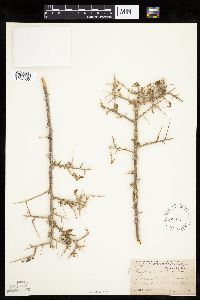 Grayia spinosa (Hooker) Moquin-Tandon 104996[1037530]Coville, Frederick; Funston, Frederick 6151891-04-14 United States, California, Inyo, Surprise Canyon. Panamint Mountains.;Death Valley National Park, 1400m |
MIN:Plants | 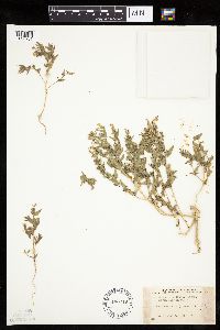 Atriplex dioica (Nuttall) J.F. Macbride 490419[1036761]Stevens, O. 7211943-07-16 United States, North Dakota, McKenzie, N. Roosevelt Park. [Theodore Roosevelt National Park] |
MIN:Plants | 487892[]Went, F. s.n.1939-10-06 United States, California, Sacramento, West Sacramento |
MIN:Plants | 454065[]Bright, R. 72-841972-00-00 United States, Idaho, Franklin, [no further data] |
MIN:Plants | 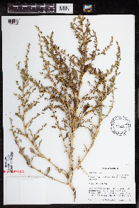 438286[1343691]Cully, Anne; et al. sn1998-08-10 United States, Minnesota, Pipestone, UTM 0714546N 4876879E [note: values should be reversed];Pipestone National Monument;106N;46W;01, 44.0137111 -96.3234175 |
MIN:Plants | 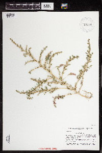 920577[1343686]Smith, Welby 200301991-08-21 United States, Minnesota, Morrison, On the south side of Pusan road, about 3 km southeast of Pillager. UTM: 388200E 5129100N. SW1/4 of NW1/4 of section;Camp Ripley Military Reservation;133N;30W;27, 46.3083333 -94.4519444 |
MIN:Plants | 504549[]Dunn, D. 113231954-08-23 United States, Montana, Flathead, 1/4 mi. NE of the Flathead R, road corner & RR cut ... 2 mi. SW of Columbia Falls. Boundary of township along SE 1/4, T30N R21W S13. Flathead Co.. 030N 21W 13, 48.363464 -114.229958, 930m |
MIN:Plants | 436906[]Budelsky, R. RAB6311998-07-22 United States, Minnesota, Carver, Carver Co, T116N R25W S16;;116N;25W;16, 44.855363 -93.838918 |
MIN:Plants | 105518[]Burglehaus, F. s.n.1894-09-17 United States, Wyoming, Park, Yellowstone Park...Near Mammoth Hot Springs;Yellowstone National Park, 1829m |
MIN:Plants | 105525[]Ballard, C. 26031900-08-00 United States, Minnesota, Kittson, Humboldt.;;163N;50W;, 48.93381 -97.128306 |
MIN:Plants | 105526[]Moyer, Lycurgus s.n.1892-08-00 United States, Minnesota, Chippewa, Montevideo;;117N;40W;, 44.934626 -95.675774 |
MIN:Plants | 105528[]Oestlund, O. 118-21888-08-18 United States, Minnesota, Hennepin, [no further data];;;;, 45 -93.47 |
MIN:Plants | 105529[]Oestlund, O. 412-21888-08-18 United States, Minnesota, Hennepin, [no further data];;;;, 45 -93.47 |
MIN:Plants | 105530[]Sheldon, Edmund S15841891-08-00 United States, Minnesota, Lincoln, Lake Benton;;109N;45W;00, 44.241082 -96.261721 |
MIN:Plants | 105531[]Anonymous [poss. J.M. Holzinger] 23691886-08-00 United States, Minnesota, Winona, [no further data];;;;, 43.963131 -91.691238 |
MIN:Plants | 105532[]Sandberg, John s.n.1889-08-00 United States, Minnesota, Hennepin, [no further data];;;;, 45 -93.47 |
MIN:Plants | 105533[]Sandberg, John s.n.1886-08-00 United States, Minnesota, Goodhue, [no further data];;;;, 44.41 -92.72 |
MIN:Plants | 105534[]Manning, Sara s.n.1884-08-24 United States, Minnesota, Wabasha, Lake City.;;111N;12W;, 44.4081 -92.252454 |
MIN:Plants | 105535[]Holzinger, John s.n.1889-09-00 United States, Minnesota, Winona, [no further data];;;;, 43.963131 -91.691238 |
MIN:Plants | 105536[]MacMillan, C.; Skinner, A. 4071900-08-00 United States, Minnesota, Polk, Crookston;;150N;46W;30, 47.782 -96.60007 |
MIN:Plants | 105539[]Roberts, Thomas s.n.1879-09-01 United States, Minnesota, Saint Louis, Minnesota Point;Minnesota Point;049N;13W;18, 46.72833 -92.04778 |
MIN:Plants | 105540[]Aiton, G. s.n.1889-08-00 United States, Minnesota, Stearns, [no further data];;;;, 45.552153 -94.613011 |
MIN:Plants | 105541[]Ballard, C. 26911900-08-00 United States, Minnesota, Kittson, Northcote.;;162N;49W;, 48.84528 -97.00083 |
MIN:Plants | 224526[]Sheldon, Edmund S.34901893-00-00 United States, Minnesota, Lake, Two Harbors;North Shore;052N;11W;, 47.02278 -91.67056 |
MIN:Plants | 336962[]Lakela, Olga 17141936-08-16 United States, Minnesota, Saint Louis, Oatka Beach Addition, at 42nd St.;Minnesota Point;049N;13W;18, 46.74205 -92.06285 |
MIN:Plants |  346320[]Grant, Martin 68451936-08-28 United States, Minnesota, Clearwater, On Beaver Dam, La Salle Creek. NE-SE of section;Itasca State Park;143N;36W;06, 47.231341 -95.28645 |
MIN:Plants | 358538[]Buell, Murray 18261939-08-26 United States, Minnesota, Clearwater, [no further data];Itasca State Park;143N;36W;, 47.19557 -95.233216 |
MIN:Plants | 360302[]Lakela, Olga 40201940-08-13 United States, Minnesota, Carlton, Highway 23, about 3 mi NW of Holyoke;;;;, 46.498146 -92.433117 |
MIN:Plants | 364633[]Moyle, J. 30371937-09-05 United States, Minnesota, Clearwater, Near Upper Rice Lake;;;;, 47.394914 -95.293022 |
MIN:Plants | 370677[]Moore, John; Moore, Marjorie 136451940-09-28 United States, Minnesota, Ramsey, Mounds View Township. SE1/4 of section;;030N;23W;08, 45.100763 -93.198544 |
MIN:Plants | 396951[]Stevens, O. s.n.1947-09-12 United States, Minnesota, Clay, River;Buffalo River State Park;139N;46W;10, 46.869327 -96.473428 |
MIN:Plants | 407166[]Lakela, Olga 97411949-09-12 United States, Minnesota, Saint Louis, S of Ely;Superior National Forest;;;, 47.903237 -91.867087 |
MIN:Plants | 412914[]Moore, John; et al. 114151939-08-03 United States, Minnesota, Roseau, Roseau County...along rr right-of-way N of Longworth school;;;;, 48.993543 -95.365029 |
MIN:Plants |  443948[1343688]Abbott, Robinson s.n.1961-08-19 United States, Minnesota, Stevens, Access to S. Pomme de Terre [= Perkins] Lake, rt. 59, N. of Morris.;;126N;41W;30, 45.694215 -95.871827 |
MIN:Plants |  448286[]Moore, John; Huff, N. 191471946-08-29 United States, Minnesota, Koochiching, Gravel pit, 5 mi north east of Northome.;;151N;28W;, 47.889524 -94.227769 |
MIN:Plants | 494406[]Huff, N. s.n.1941-08-17 United States, Minnesota, Hubbard, Park Rapids;;;;, 46.922181 -95.058632 |
MIN:Plants | 501529[]Stevens, O. s.n.1954-09-14 United States, Minnesota, Pipestone, Pipestone;;106N;46W;, 43.979723 -96.367859 |
MIN:Plants | 514645[]Dewart, F. s.n.1892-09-00 United States, Minnesota, Stearns, St. Cloud. Stearns Co.;;N;;, 45.55 -94.166667 |
MIN:Plants | 525607[]Lakela, Olga 195771955-09-26 United States, Minnesota, Saint Louis, UMD [Univ. of Minn. Duluth] campus;;050N;14W;14, 46.815354 -92.080163 |
MIN:Plants |  542698[1343685]Moore, John 218311954-07-20 United States, Minnesota, Wilkin, 2 1/2 mi S of Breckenridge;;N;;, 46.227375 -96.588129 |
MIN:Plants | 558491[]Moore, John; et al. 235661957-09-19 United States, Minnesota, Isanti, Isanti County...NW1/4 S16, Athens Twp, Cedar Creek Forest;Cedar Creek National History Area;034N;23W;16, 45.435724 -93.214819 |
MIN:Plants | 565128[]Cotter Tucker, Shirley 4189 United States, Minnesota, Polk, Polk Co.; along Great Northern rr E of Northwest School of Agriculture, Crookston;;150N;46W;, 47.80378 -96.546331 |
MIN:Plants |  566338[1343690]Moore, John; Bernardini, J. 243151958-09-19 United States, Minnesota, Blue Earth, Blue Earth River 1 mi S of Mankato;;;;, 44.150847 -94.032276 |
MIN:Plants |  745265[1343687]Smith, Welby 55511981-08-26 United States, Minnesota, Mower, About 2 mi ESE of the junction of State Highway 56 and County Highway 2 in Brownsdale. SE1/4 SE1/4 of section;Wild Indigo Scientific Natural Area;103N;17W;11, 43.739545 -92.839221 |
MIN:Plants |  813521[1343689]Wheeler, Gerald 123571988-09-25 United States, Minnesota, Big Stone, Ca. 14 mi NW of Ortonville; N of Rte 7. N of moranic hill overlooking Big Stone Lake. NW1/4 SW1/4 of section;;123N;48W;35, 45.421214 -96.646948 |
MIN:Plants | 105527[]Ballard, C. s.n.1900-08-00 United States, Minnesota, Kittson, Kennedy.;;160N;49W;, 48.673805 -96.975896 |
MIN:Plants | 105538[]Holzinger, John s.n.1886-07-00 United States, Minnesota, Winona, [no further data];;;;, 44.0479 -91.6404 |
MIN:Plants | 443937[]Abbott, Robinson s.n.1961-09-15 United States, Minnesota, Stevens, By prairie tract, UMM [Univ. of Minn.] Morris.;;125N;41W;31, 45.592721 -95.871809 |
MIN:Plants | 553844[]Moore, John 226011955-07-26 United States, Minnesota, Clay, Across the road from the entrance.;Buffalo River State Park;139N;46W;10, 46.869327 -96.473428 |
MIN:Plants |  554640[]Moore, John; Hsi, Yu-tseng [Eugene] 233011957-08-05 United States, Minnesota, Blue Earth, N shore of Eagle Lake.;;;;, 44.189661 -93.896402 |
MIN:Plants | 743812[]Ownbey, Gerald 68691982-09-30 United States, Minnesota, Washington, Stillwater. At St. Croix Mall parking lot.;;030N;20W;, 45.084979 -92.817348 |
MIN:Plants | 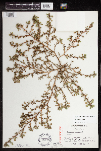 747215[1343684]Galatowitsch, S. 8291982-09-15 United States, Minnesota, Wabasha, SE1/4 and E1/2 NE1/4 of Sec. 7; NW1/4 and W1/2 NE1/4 of Sec. 8.;Kellogg-Weaver Dunes Scientific Natural Area / Kellogg-Weaver Dunes, The Nature Conservancy;109N;09W;, 44.2331079 -91.9172451 |
MIN:Plants | 493655[]Went, F. s.n.1939-11-05 United States, California, Yolo, Davis |
MIN:Plants | 630514[]Halse, Richard 7491971-09-03 United States, Arizona, Apache, Canyon de Chelly National Monument. staff housing, trailer house area, south of the Headquarters for Canyon de Chelly National Monument; T5N, R10W, Sec. 22...Apache County., 1689m |
MIN:Plants | 910784[]Smith, Welby 219151992-09-03 United States, Minnesota, Watonwan, At the east end of St. James Lake, just southwest of the town of St. James. SW1/4 of NE1/4 of section SW1/4 of NE1/4 of Sec 23. 106N 32W 23, 43.975 -94.6430556 |
MIN:Plants | 933910[]Smith, Welby R. 214211992-08-12 United States, Minnesota, Marshall, About 11 miles east of Argyle. NW1/4 of SE1/4 of section;Old Mill State Park;156N;46W;04, 48.3602778 -96.5702778 |
MIN:Plants | 832115[]Aiton, G. 1890-08-00 United States, Minnesota, [no further data];;;;, 46 -94 |
MIN:Plants | Suaeda calceoliformis (Hooker) Moquin-Tandon 735235[]Bright, R. 72-141972-00-00 United States, Idaho, Franklin, [no further data] |
MIN:Plants | 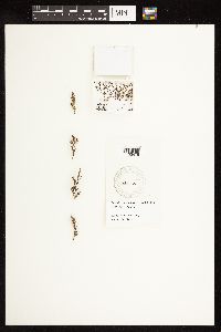 Suaeda calceoliformis (Hooker) Moquin-Tandon 435232[1122478]Bright, R. 72-131972-00-00 United States, Idaho, Franklin, [no further data] |
MIN:Plants | Suaeda calceoliformis (Hooker) Moquin-Tandon 435233[]Bright, R. 71-201971-00-00 United States, Idaho, Bannock, [no further data] |
MIN:Plants | 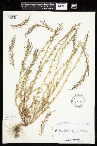 Suaeda calceoliformis (Hooker) Moquin-Tandon 479706[1037708]Schimpf, D. DJS2581995-09-03 United States, Minnesota, Saint Louis, St. Louis Co, Midway Twp. T49N R15W SE Sec 19 & SW Sec 20 ... exit & entry ramps for Midway Rd at N-bound I-35.;;049N;15W;00, 46.7083321 -92.2833328 |
MIN:Plants |  Suaeda calceoliformis (Hooker) Moquin-Tandon 777715[1037710]Boe, J. 21041984-06-25 United States, Minnesota, Wilkin, SW1/4 SW1/4 of section;Western Prairie South Scientific Natural Area;135N;46W;12, 46.521816 -96.414416 |
MIN:Plants | 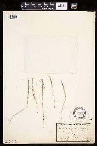 Suaeda calceoliformis (Hooker) Moquin-Tandon 104885[1037709]MacMillan, C.; et al. 4081900-08-00 United States, Minnesota, Polk, Crookston;;150N;46W;30, 47.77414 -96.60812 |
MIN:Plants | 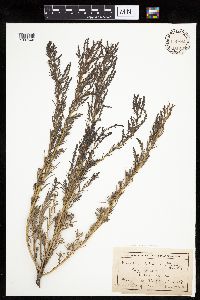 Suaeda calceoliformis (Hooker) Moquin-Tandon 104886[1037640]Ballard, C. 26181900-08-00 United States, Minnesota, Kittson, Humboldt;;163N;50W;, 48.93381 -97.128306 |
MIN:Plants | 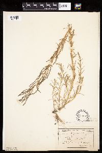 Suaeda calceoliformis (Hooker) Moquin-Tandon 104888[1037713]Ballard, C. 27591900-08-00 United States, Minnesota, Kittson, Hallock;;161N;49W;, 48.76042 -96.99613 |
MIN:Plants | 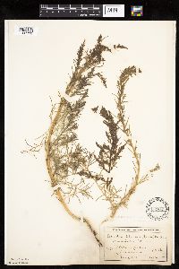 Suaeda calceoliformis (Hooker) Moquin-Tandon 104889[1037720]MacMillan, C.; et al. 113Sk1900-08-00 United States, Minnesota, Polk, Crookston;;150N;46W;30, 47.77414 -96.60812 |
Google Map
Google Maps is a web mapping service provided by Google that features a map that users can pan (by dragging the mouse) and zoom (by using the mouse wheel). Collection points are displayed as colored markers that when clicked on, displays the full information for that collection. When multiple species are queried (separated by semi-colons), different colored markers denote each individual species.