University of Minnesota
http://www.umn.edu/
612-625-5000
http://www.umn.edu/
612-625-5000
Minnesota Biodiversity Atlas
Bell Museum
Dataset: MIN-Plants
Taxa: Amaranthaceae
Search Criteria: excluding cultivated/captive occurrences
Bell Museum plants | |
 MIN:Plants |  Suaeda calceoliformis (Hooker) Moquin-Tandon 104890[1037719]Ballard, C. 25421900-08-00 United States, Minnesota, Otter Tail, Fergus Falls;;N;;, 46.238762 -96.080589 |
MIN:Plants |  Suaeda calceoliformis (Hooker) Moquin-Tandon 104891[1037714]Ballard, C. 26131900-08-00 United States, Minnesota, Kittson, Humboldt;;163N;50W;, 48.93381 -97.128306 |
MIN:Plants |  Suaeda calceoliformis (Hooker) Moquin-Tandon 104892[1037716]Ballard, C. 27931900-08-00 United States, Minnesota, Marshall, Warren;;N;;, 48.196642 -96.77284 |
MIN:Plants |  Suaeda calceoliformis (Hooker) Moquin-Tandon 104894[1037715]Ballard, C. 27011900-08-00 United States, Minnesota, Kittson, Northcote;;162N;49W;, 48.84732 -96.99641 |
MIN:Plants |  Suaeda calceoliformis (Hooker) Moquin-Tandon 412035[1037711]Moore, John; Moore, Marjorie 115041939-08-07 United States, Minnesota, Kittson, 1 mi S of Noyes;;N;;, 48.983016 -97.204507 |
MIN:Plants |  Suaeda calceoliformis (Hooker) Moquin-Tandon 412377[1037718]Moore, John; Moore, Marjorie 115761939-08-09 United States, Minnesota, Kittson, N edge of the NW1/4 of S34, Clow Twp;;163N;49W;34, 48.897798 -96.985906 |
MIN:Plants |  Suaeda calceoliformis (Hooker) Moquin-Tandon 554421[1037717]Moore, John 230231956-09-13 United States, Minnesota, Clay, 3 1/2 mi NW of Barnesville;;N;;, 46.687999 -96.471987 |
MIN:Plants |  Suaeda calceoliformis (Hooker) Moquin-Tandon 558351[1037712]Moore, John 236391957-09-25 United States, Minnesota, Clay, 1 mi NW of Barnesville;;N;;, 46.662418 -96.434703 |
MIN:Plants |  Suaeda calceoliformis (Hooker) Moquin-Tandon 707937[1037700]Smith, Welby 12561979-08-03 United States, Minnesota, Lac Qui Parle, T117N, R46W, N1/2 S8. "Salt Lake". 3.5 mi SSW of Marietta. Along SE shore, growing 2 to 3 ft from edge of lake.;;117N;46W;8, 44.957871 -96.443745 |
MIN:Plants |  Suaeda calceoliformis (Hooker) Moquin-Tandon 709318[1037722]Wheeler, Gerald 43101979-07-10 United States, Minnesota, Lac Qui Parle, Salt Lake. Ca 3.5 mi SW of Marietta, near the shore of the lake. T117N, R46W, S5.;;117N;46W;5, 44.972372 -96.443681 |
MIN:Plants |  Suaeda calceoliformis (Hooker) Moquin-Tandon 728406[1037721]Huber, R. s.n.1980-08-09 United States, Minnesota, Kittson, ca 0.6 mi N of Humboldt on Rte 75;;N;;, 48.929779 -97.093393 |
MIN:Plants |  Suaeda calceoliformis (Hooker) Moquin-Tandon 730694[1037706]Petron, T. 2221980-07-14 United States, Minnesota, Wilkin, Western Prairie South: 6.5 mi NW of Rothsay. SW1/4 SW1/4 S12, T135N, R46W.;Western Prairie South Scientific Natural Area;135N;46W;12, 46.521816 -96.414416 |
MIN:Plants |  Suaeda calceoliformis (Hooker) Moquin-Tandon 739763[1037701]Converse, C. 20991982-08-24 United States, Minnesota, Otter Tail, Otter Tail Preserve: T131N, R44W, NW1/4 NE1/4 S17.;Ottertail Prairie Scientific Natural Area;131N;44W;17, 46.159244 -96.235363 |
MIN:Plants |  Suaeda calceoliformis (Hooker) Moquin-Tandon 782167[1037703]Dana, R. 851451985-09-15 United States, Minnesota, Wilkin, W1/2 SE1/4 S34, T136N, R46W.;;136N;46W;34, 46.550637 -96.456657 |
MIN:Plants |  Suaeda calceoliformis (Hooker) Moquin-Tandon 782168[1037707]Dana, R. 850991985-08-12 United States, Minnesota, Wilkin, N end of W1/2 S11, T133N, R45W;;133N;45W;11, 46.34787 -96.311865 |
MIN:Plants |  Suaeda calceoliformis (Hooker) Moquin-Tandon 782180[1037704]Dana, R. 850831985-07-29 United States, Minnesota, Wilkin, NW1/4 S29, T135N, R45W;;135N;45W;29, 46.478451 -96.375285 |
MIN:Plants |  Suaeda calceoliformis (Hooker) Moquin-Tandon 795548[1037705]Cholewa, A. 14551987-07-23 United States, Minnesota, Clay, 4 mi S of Felton; E side of hwy 9; at N end of WMA.;Flowing Prairie Wildlife Management Area;141N;46W;22, 47.013438 -96.489328 |
MIN:Plants |  Suaeda calceoliformis (Hooker) Moquin-Tandon 831753[1037702]Harris, Fred 923031992-08-30 United States, Minnesota, Pennington, Pennington Co. E of marshes in Goose Lake prairie-wetland complex; NE1/4 NE1/4 Sec.8 T153N R45W;;153N;45W;8, 48.086851 -96.468647 |
MIN:Plants |  Suaeda calceoliformis (Hooker) Moquin-Tandon 435236[1122477]Bright, R. 72-91972-00-00 United States, Idaho, Franklin, [no further data] |
MIN:Plants | Suaeda calceoliformis (Hooker) Moquin-Tandon 435234[]Bright, R. 72-101972-00-00 United States, Idaho, Franklin, [no further data] |
MIN:Plants | Suaeda calceoliformis (Hooker) Moquin-Tandon 435235[]Bright, R. 72-141972-00-00 United States, Idaho, Franklin, [no further data] |
MIN:Plants |  Suaeda calceoliformis (Hooker) Moquin-Tandon 968058[1368695]Timothy J. S. Whitfeld 14732016-09-17 United States, Rhode Island, Bristol, Tillinghast Farm, Rhode Island School of Design Beach, 0.25 miles southwest of intersection between Nyatt Road and Freemont Avenue., 41.72567 -71.32468 |
MIN:Plants |  906490[1037011]Smith, Welby 311472008-08-18 United States, Minnesota, Beltrami, Beltrami County...About 12 miles north-northeast of Bemidji...T 148 R 33 SW1/4 of NE1/4 of sec 12;Buena Vista State Forest;148N;33W;12, 47.6522222 -94.8072222 |
MIN:Plants |  461797[1036918]Husveth, J. 95-45421995-08-31 United States, Minnesota, Wabasha, Wabasha Co, T110N R12W SW1/4 of the SE1/4 of S27; Zumbro River;Dorer Memorial Hardwood State Forest;110N;12W;27, 44.302288 -92.23979 |
MIN:Plants |  493272[1036936]Smith, Welby 157381989-07-17 United States, Minnesota, Benton, Benlacs Wildlife Management Area. Benton County...Benlacs State Wildlife Management Area, about 7 miles SE of Foley...SE1/4 SE1/4 section 12, T36N R28W.. 036N 28W 12, 45.625853 -93.770684 |
MIN:Plants |  484686[1036952]Swanson, Gary 4572001-08-14 United States, Minnesota, Morrison, FQURU1-1 off transect. NE1/4 NW1/4 of section;Crane Meadows National Wildlife Refuge;040N;31W;30, 45.933896 -94.251564 |
MIN:Plants |  914294[1036966]Smith, Welby 255561994-09-20 United States, Minnesota, Dakota, Gores Pool Wildlife Management Area. Dakota County...Gores State Wildlife Management Area, about 5 miles east-southeast of Hasting. Along the banks of the Vermillion river...T 114N R 16W NE1/4 of SE1/4 of Sec 5. 114N 16W 5, 44.7080556 -92.7575 |
MIN:Plants |  478830[1036950]Husveth, J. 95-31581995-08-30 United States, Minnesota, Wabasha, Wabasha Co, T110N R12W SW1/4 of the NE1/4 of S36; along Zumbro River.;Dorer Memorial Hardwood State Forest;110N;12W;36, 44.287627 -92.199704 |
MIN:Plants |  896443[1036851]Smith, Welby 157961989-07-18 United States, Minnesota, Freeborn, Freeborn County...At the south end of Geneva Lake, about 3 miles northeast of Clarks Grove...NE1/4 NE1/4 section 30, T 104N R 20W. 104N 20W 30, 43.782027 -93.279448 |
MIN:Plants |  104340[1037018]Nelson, Aven; et al. 67531899-08-29 United States, Wyoming, Park, Yellowstone National Park...Madison Canyon;Yellowstone National Park |
MIN:Plants | 499361[]Went, F. s.n.1943-06-00 United States, California, Yolo, Davis |
MIN:Plants |  246435[1037019]Mearns, E. 14351902-06-29 United States, Wyoming, Park, Yellowstone National Park...Mammoth Hot Springs;Yellowstone National Park |
MIN:Plants |  896901[1036869]Haferman, J. 2781996-08-10 United States, Minnesota, Scott, Approximately 0.1 miles north-northeast of intersection of State Highway 13 and County Road 44, north side of highway. SW of SW of section;;115N;22W;36, 44.7245862 -93.4090306 |
MIN:Plants |  920886[1036839]Smith, Welby 173421990-07-18 United States, Minnesota, Morrison, Camp Ripley Military Reservation. Camp Ripley Military Reservation. Morrison County...About 0.5 km east of Round Lake...UTM: 389100E 5109800N... T 131N R 30W NE1/4 of NE1/4 of Sec 27. 131N 30W 27, 46.1347222 -94.4355556 |
MIN:Plants |  913598[1036922]Smith, Welby 230391993-07-21 United States, Minnesota, Meeker, Meeker County... On the south side of T.H. 12; about 2 miles southeast of Darwin... T119N R30W NW1/4 of SE1/4 of Sec 25;;119N;30W;25, 45.0872222 -94.3916667 |
MIN:Plants |  295956[1037021]Clokey, Ira 49171930-07-02 United States, California, Santa Barbara, Santa Barbara Islands...Pelican Bay...Santa Cruz Island;Channel Islands |
MIN:Plants |  491192[1036850]Wheeler, Gerald 175041997-08-31 United States, Minnesota, Renville, Renville County ... Ca. 3 mi. W of Bird Island on Rte. 212; along railroad tracks ... N1/2 N1/2 Sec. 16 T115N R34W;;115N;34W;16, 44.767288 -94.94582 |
MIN:Plants |  912104[1036938]Smith, Welby 254431994-09-08 United States, Minnesota, Beltrami, Beltrami County...At the Waskish Municipal Campground...Highway 72...T 154N R 30W SE1/4 of NE1/4 of Sec 8;;154N;30W;08, 48.1722222 -94.5116667 |
MIN:Plants |  898966[1036895]Smith, Welby 257841995-07-26 United States, Minnesota, Sherburne, Sherburne County...Along the Blue Hill Trail in Sherburne National Wildlife Refuge...T35N R27W NW1/4 of SW1/4 of Sec 28;Sherburne National Wildlife Refuge;035N;27W;28, 45.4991667 -93.7111111 |
MIN:Plants |  104377[1122494]Burglehaus, F. s.n.1890-09-00 United States, Minnesota, Hennepin, [no further data];;;;, 45 -93.47 |
MIN:Plants |  104378[1036969]Roberts, Thomas s.n.1879-08-13 United States, Minnesota, Cook, Grand Marais;North Shore / Superior National Forest;061N;01E;, 47.777456 -90.325243 |
MIN:Plants |  104379[1036958]Ballard, C. 26971900-08-00 United States, Minnesota, Kittson, Northcote.;;162N;49W;, 48.84528 -97.00083 |
MIN:Plants |  104381[1036996]MacMillan, C.; et al. MS 11721894-07-00 United States, Minnesota, Lake of the Woods, Oak Point [Lake of the Woods Co. according to other collections by M&S];Pine & Curry Islands Scientific Natural Area;162N;31W;06, 48.87976 -94.690246 |
MIN:Plants |  104382[1036862]Ballard, C. 25271900-08-00 United States, Minnesota, Otter Tail, Fergus Falls;;N;;, 46.238762 -96.080589 |
MIN:Plants |  104383[1036861]Menzel, Max s.n.1895-08-00 United States, Minnesota, Pipestone, Pipestone [assuming the quarry area; town generally noted as Pipestone City by collector];Pipestone National Monument;106N;46W;01, 44.01585 -96.31767 |
MIN:Plants |  104385[1037004]Manning, Sara s.n.1884-06-20 United States, Minnesota, Wabasha, Lake City;;N;;, 44.4081 -92.252454 |
MIN:Plants |  104386[1036994]Moyer, Lycurgus 13591895-07-00 United States, Minnesota, Chippewa, Montevideo;;117N;40W;, 44.934626 -95.675774 |
MIN:Plants |  104387[1036995]Ballard, C. 25751900-08-00 United States, Minnesota, Kittson, St. Vincent;;163N;51W;, 48.945898 -97.210703 |
MIN:Plants |  104388[1036836]Ballard, C. 27081900-08-00 United States, Minnesota, Kittson, Northcote.;;162N;49W;, 48.84528 -97.00083 |
MIN:Plants |  104389[1036982]Ballard, C. 30971901-08-12 United States, Minnesota, Clay, Muskoda [historic RR station near Hawley];;139N;45W;17, 46.854548 -96.396768 |
MIN:Plants |  104390[1036976]Moyer, Lycurgus 13591898-07-25 United States, Minnesota, Chippewa, Montevideo;;117N;40W;, 44.934626 -95.675774 |
MIN:Plants |  104392[1036968]Herrick, C. 407-11877-06-26 United States, Minnesota, Hennepin, Minneapolis;;N;;, 44.979965 -93.263836 |
MIN:Plants |  104393[1036896]Ballard, C. B6641891-07-00 United States, Minnesota, Carver, Waconia;;116N;25W;, 44.8476 -93.827753 |
MIN:Plants |  104394[1036970]Arthur, J.; et al. B5231886-07-29 United States, Minnesota, Lake, Agate Bay;North Shore;052N;11W;01, 47.01954 -91.67918 |
MIN:Plants |  104395[1036956]Menzel, Max s.n.1894-08-00 United States, Minnesota, Pipestone, Pipestone [assuming the quarry area; town generally noted as Pipestone City by collector];Pipestone National Monument;106N;46W;01, 44.01585 -96.31767 |
MIN:Plants |  104396[1036991]Ballard, C. 27401900-08-00 United States, Minnesota, Kittson, Hallock, Kittson Co.;;161N;49W;, 48.760418 -96.996127 |
MIN:Plants |  104397[1036967]Sandberg, John s.n.1884-09-00 United States, Minnesota, Goodhue, Red Wing.;;113N;14W;, 44.555216 -92.495543 |
MIN:Plants |  104398[1036891]MacMillan, C.; et al. 119Sk1900-08-00 United States, Minnesota, Polk, Crookston;;150N;46W;30, 47.782 -96.60007 |
MIN:Plants |  104399[1037000]Ainslie, G. 13591902-06-19 United States, Minnesota, Olmsted, Rochester;;106N;14W;, 43.97834 -92.49834 |
MIN:Plants |  104400[1036833]Rosendahl, C. 6511902-06-30 United States, Minnesota, Houston, Spring Grove;;101N;07W;, 43.543923 -91.6707 |
MIN:Plants |  104402[1037017]MacMillan, C.; Sheldon, Edmund 25081894-07-28 Canada, Ontario, Kenora, Massacre Island |
MIN:Plants |  104403[1036889]Ballard, C. 25521900-08-00 United States, Minnesota, Kittson, St. Vincent;;163N;51W;, 48.945898 -97.210703 |
MIN:Plants |  104404[1036830]Skinner, A. 191900-08-00 United States, Minnesota, Polk, Crookston;;N;;, 47.774138 -96.608121 |
MIN:Plants |  104405[1036985]Ballard, C. 27211900-08-00 United States, Minnesota, Kittson, Kennedy.;;160N;49W;, 48.673805 -96.975896 |
MIN:Plants |  104483[1122495]Aiton, G. s.n.1889-07-20 United States, Minnesota, Hennepin, [no further data];;;;, 45 -93.47 |
MIN:Plants |  104623[1036890]Rosendahl, C. 6421902-06-30 United States, Minnesota, Houston, Spring Grove;;101N;07W;, 43.543923 -91.6707 |
MIN:Plants |  104628[1036977]Aiton, G.; Moyer, Lycurgus s.n.1896-09-21 United States, Minnesota, Chippewa, Montevideo;;117N;40W;, 44.934626 -95.675774 |
MIN:Plants |  104772[1036873]Ballard, C. 25941900-08-00 United States, Minnesota, Kittson, Humboldt.;;163N;50W;, 48.93381 -97.128306 |
MIN:Plants |  264165[1122493]Holzinger, John s.n.1901-00-00 United States, Minnesota, Winona, Winona Co.;;N;;, 43.963131 -91.691238 |
MIN:Plants |  265498[1036907]Anonymous G251912-00-00 United States, Minnesota, Rice, Northfield;;N;;, 44.458298 -93.161604 |
MIN:Plants |  277569[1036897]Hotchkiss, N.; et al. 3081930-07-19 United States, Minnesota, Jackson, Jackson Co. Near Little Spirit Lake;;;;, 43.50885 -95.12694 |
MIN:Plants | 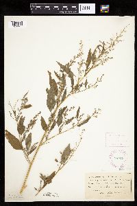 277719[1036865]Roberts, Thomas s.n1878-09-04 United States, Minnesota, Hennepin, Minneapolis;;N;;, 44.979965 -93.263836 |
MIN:Plants | 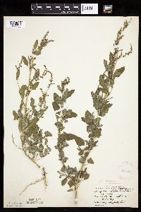 282537[1036835]Stevens, O. s.n.1933-09-17 United States, Minnesota, Clay, Barnesville;;N;;, 46.652182 -96.41979 |
MIN:Plants | 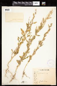 306656[1036992]Stevenson, J. 3751912-08-28 United States, Minnesota, Itasca, Grand Rapids;;N;;, 47.237166 -93.530214 |
MIN:Plants | 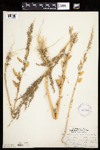 337039[1036892]Lakela, Olga 17151936-08-16 United States, Minnesota, Saint Louis, Oatka Beach Addition near Minnesota Ave, at 42nd. Street, Duluth;;N;;, 46.74205 -92.06285 |
MIN:Plants |  337045[1036832]Lakela, Olga 17571936-08-19 United States, Minnesota, Saint Louis, Along Minnesota Ave, at 14th Street, Duluth;;N;;, 46.74205 -92.06285 |
MIN:Plants |  351559[1036834]Benner, F.; Benner, J. 5151929-07-27 United States, Minnesota, Cook, Near McLean's Cottage, Grand Portage;Grand Portage Indian Reservation / North Shore;063N;06E;, 47.958468 -89.703576 |
MIN:Plants |  351594[1036829]Jukkola, E. 231937-06-22 United States, Minnesota, Hennepin, Near barge terminal, Mississippi River flats, S of Washington Ave. bridge, Minneapolis;;N;;, 44.97294 -93.23925 |
MIN:Plants |  351595[1036864]Eneboe, H. 201937-06-18 United States, Minnesota, Hennepin, Barge terminal, Mississippi River flats, S of Washington Avenue bridge, Minneapolis;;N;;, 44.973 -93.23977 |
MIN:Plants |  352695[1036999]Benner, F.; Benner, J. 6871929-08-23 United States, Minnesota, Cook, Roadside 1/2 mi E Grand Portage;Grand Portage Indian Reservation / North Shore;063N;06E;, 47.958468 -89.703576 |
MIN:Plants |  354658[1036893]Moyle, J. 12781934-07-21 United States, Minnesota, Cass, Near Cass Lake;Leech Lake Indian Reservation;N;;, 47.41903 -94.53255 |
MIN:Plants |  355502[1036837]Norman, Robert s.n.1939-07-24 United States, Minnesota, Saint Louis, East Boulevard, Duluth;;N;;, 46.783273 -92.106579 |
MIN:Plants |  357044[1036972]Anonymous 1261912-08-01 United States, Minnesota, Saint Louis, Meadowlands.;;N;;, 47.071884 -92.732416 |
MIN:Plants |  359233[1036878]Alaspa, E.; Alaspa, H. s.n.1940-08-15 United States, Minnesota, Carlton, Cloquet;;N;;, 46.72161 -92.459357 |
MIN:Plants |  364248[1036885]Moyle, J. 30281937-09-02 United States, Minnesota, Otter Tail, Shore, E end of Otter Tail Lake;;N;;, 46.399132 -95.661637 |
MIN:Plants |  367024[1036860]Moore, John; et al. 103191938-08-14 United States, Minnesota, Dakota, 1/2 block S of Southview Blvd, on 5th Ave, South St. Paul. Dakota Co.;;028N;22W;, 44.905226 -93.045075 |
MIN:Plants |  375201[1036923]Lakela, Olga 51851942-08-30 United States, Minnesota, Pine, Pine Co, near Herrick;;045N;18W;, 46.37481 -92.615751 |
MIN:Plants |  383592[1036971]Moore, John 159471943-08-21 United States, Minnesota, Fillmore, Chatfield;;104N;11W;, 43.803917 -92.14917 |
MIN:Plants |  385733[1036960]Lakela, Olga 58681944-09-05 United States, Minnesota, Saint Louis, Along Minnesota Ave, Minnesota Point, Duluth;Minnesota Point;049N;13W;18, 46.74205 -92.06285 |
MIN:Plants |  385888[1036924]Lakela, Olga 58341944-08-26 United States, Minnesota, Carlton, 3 mi S of Fond du Lac;;N;;, 46.618709 -92.321828 |
MIN:Plants |  393007[1036978]Lakela, Olga 71461947-08-12 United States, Minnesota, Saint Louis, Road to Skibo Obeservation Tower.;;N;;, 47.485479 -91.994337 |
MIN:Plants |  393514[1036903;1036902]Stevens, O. s.n.1947-09-19 United States, Minnesota, Clay, Clay County. 6 mi east of Barnesville;;137N;44W;, 46.674239 -96.236522 |
MIN:Plants |  393516[1036959]Stevens, O. s.n.1947-09-06 United States, Minnesota, Clay, Moorhead;;139N;48W;, 46.845648 -96.728846 |
MIN:Plants |  393518[1036929]Stevens, O. s.n.1947-09-19 United States, Minnesota, Clay, 6 mi E of Barnesville;;N;;, 46.652112 -96.293247 |
MIN:Plants |  393519[1036905]Stevens, O. s.n.1947-09-16 United States, Minnesota, Clay, Near river, Moorhead;;N;;, 46.845648 -96.728846 |
MIN:Plants |  393915[1036993]Butters, F.; et al. 411938-07-07 United States, Minnesota, Cook, At the W end of Mountian Lake.;Boundary Waters Canoe Area Wilderness / Superior National Forest;065N;01E;, 48.081055 -90.315189 |
MIN:Plants |  393916[1036877]Butters, F.; Abbe, E. 9521944-08-06 United States, Minnesota, Cook, Cook Co.; Talus below W face of cliff, Clearwater Lake; T65N R1E;Boundary Waters Canoe Area Wilderness / Superior National Forest;065N;01E;, 48.081055 -90.315189 |
MIN:Plants |  393917[1036963]Nielsen, E. 17131932-09-12 United States, Minnesota, Cook, Second cliff on S side of Clearwater Lake; T65N R1E;Boundary Waters Canoe Area Wilderness / Superior National Forest;065N;01E;, 48.081055 -90.315189 |
MIN:Plants |  405969[1036904]Rosendahl, C. s.n.1948-09-00 United States, Minnesota, Ramsey, St. Anthony Park [neighborhood near U of M], St. Paul;;029N;23W;, 44.992077 -93.166387 |
MIN:Plants | 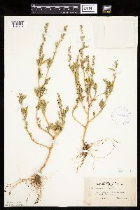 407196[1036940]Lakela, Olga 93821949-08-14 United States, Minnesota, Saint Louis, Fredenberg Lake;;N;;, 46.987037 -92.191099 |
Google Map
Google Maps is a web mapping service provided by Google that features a map that users can pan (by dragging the mouse) and zoom (by using the mouse wheel). Collection points are displayed as colored markers that when clicked on, displays the full information for that collection. When multiple species are queried (separated by semi-colons), different colored markers denote each individual species.