University of Minnesota
http://www.umn.edu/
612-625-5000
http://www.umn.edu/
612-625-5000
Minnesota Biodiversity Atlas
Bell Museum
Dataset: MIN-Plants
Taxa: Crataegus chrysocarpa
Search Criteria: excluding cultivated/captive occurrences
Bell Museum plants | |
 MIN:Plants | 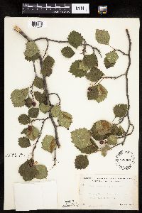 526096[1025522]Lakela, Olga 194041955-08-31 United States, Minnesota, Saint Louis, St. Louis County...Floodwood River, south of Meadowlands Jct. on highway #73.;;052N;20W;32, 46.94664 -92.90074 |
MIN:Plants | 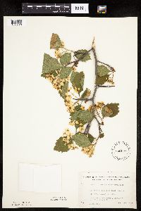 526110[1025726]Lakela, Olga 186091955-05-28 United States, Minnesota, Saint Louis, Floodwood River terrace, Hwy. 73, near Meadowlands Jct.;;N;;, 46.92556 -92.90583 |
MIN:Plants | 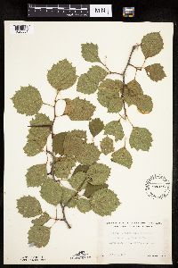 526116[1025661]Lakela, Olga 189241955-07-21 United States, Minnesota, Saint Louis, St. Louis County...above the Vermilion River Falls, 3 mi. from Gold Mine Camp.;Superior National Forest;;;, 48.275739 -92.506548 |
MIN:Plants | 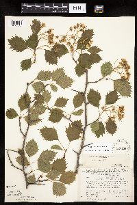 527134[1025516]Lakela, Olga 173911954-06-14 United States, Minnesota, Saint Louis, St. Louis County...Floodwood River bank, on Highway 73;;;;, 46.92823 -92.91344 |
MIN:Plants | 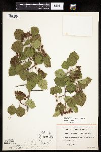 527364[1025804]Lakela, Olga 178081954-07-06 United States, Minnesota, Saint Louis, St. Louis County ... on Lac La Croix at Beatty Portage;Boundary Waters Canoe Area Wilderness / Superior National Forest;067N;15W;20, 48.27403 -92.2871 |
MIN:Plants | 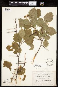 527438[1025762]Lakela, Olga 177211954-07-02 United States, Minnesota, Saint Louis, Iron River below Curtain Falls, Canadian boundary;Boundary Waters Canoe Area Wilderness / Superior National Forest;066N;12W;06, 48.23079 -91.91703 |
MIN:Plants | 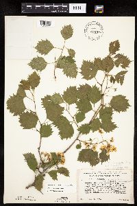 527450[1025582]Lakela, Olga 173901954-06-14 United States, Minnesota, Saint Louis, Floodwood River bank on Highway 73, about 5 mi. n. of Floodwood.;;052N;20W;00, 46.98261 -92.86869 |
MIN:Plants | 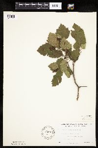 532388[1025544]Lakela, Olga 203551956-07-10 United States, Minnesota, Saint Louis, Floodwood Lake on the Resort grounds, W. of Highway No. 73;;;;, 47.16509 -93.05111 |
MIN:Plants | 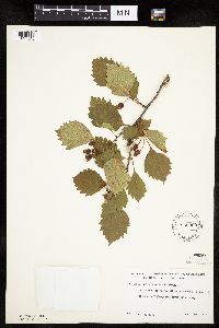 532900[1025543]Lakela, Olga 200851956-06-25 United States, Minnesota, Saint Louis, Willow River southeast of the bridge on Highway #5, south of Greeney;;;;, 47.95636 -93.02193 |
MIN:Plants | 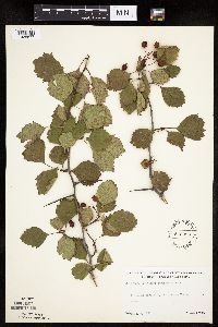 542956[1025677]Lakela, Olga 222061957-09-03 United States, Minnesota, Saint Louis, St. Louis County...St. Louis River Valley, Palo;;057N;15W;00, 47.41532 -92.23971 |
MIN:Plants | 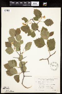 542959[1025585]Lakela, Olga 213281957-06-02 United States, Minnesota, Saint Louis, Section of Swan River, Swan River off W of of hwy no. 5, N of Toivola;;N;;, 47.24754 -92.83722 |
MIN:Plants | 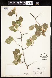 543034[1025727]Lakela, Olga 21344a1957-06-08 United States, Minnesota, Lake, Kawishiwi River bank at the Park House.;Boundary Waters Canoe Area Wilderness / Superior National Forest;N;;, 47.90556 -91.71722 |
MIN:Plants | 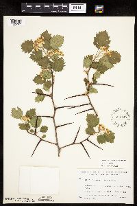 543049[1025563]Lakela, Olga 213241957-06-01 United States, Minnesota, Saint Louis, St. Louis County...Prairie Lake southwestern corner of the county;;050N;20W;29, 46.78795 -92.9029 |
MIN:Plants | 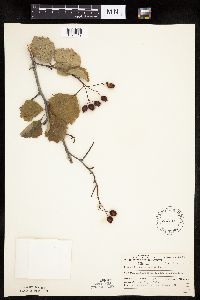 543107[1025549]Lakela, Olga 223961957-09-10 United States, Minnesota, Lake, Washington Island, Basswood Lake...Lake County;Boundary Waters Canoe Area Wilderness / Superior National Forest;064N;10W;03, 48.05294 -91.59372 |
MIN:Plants | 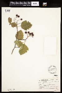 543133[1025540]Lakela, Olga 223951957-09-10 United States, Minnesota, Lake, Washington Island, Basswood Lake;Boundary Waters Canoe Area Wilderness / Superior National Forest;064N;10W;03, 48.05294 -91.59372 |
MIN:Plants | 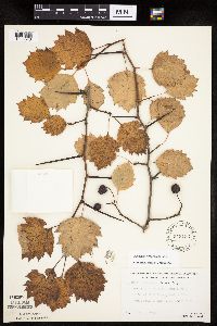 543153[1025546]Lakela, Olga; Elwell, M. 211681956-09-30 United States, Minnesota, Saint Louis, .Prairie Lake;;050N;20W;29, 46.78795 -92.9029 |
MIN:Plants | 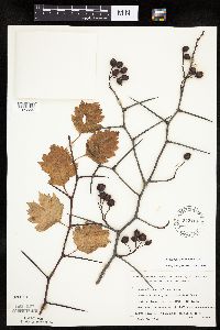 543154[1025556]Lakela, Olga 211731956-09-30 United States, Minnesota, Saint Louis, St. Louis County...about 3 mi. n. of Floodwood, on Floodwood River;;052N;21W;29, 46.96145 -93.0263 |
MIN:Plants | 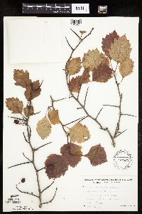 543172[1025674]Lakela, Olga 211671956-09-30 United States, Minnesota, Saint Louis, St. Louis County...Town line road, Little Swan River Valley, S.E. of Hibbing;;;;, 47.29722 -92.83083 |
MIN:Plants | 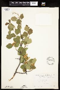 543214[1025623]Lakela, Olga 196671956-06-09 United States, Minnesota, Saint Louis, St. Louis County...Palo near St. Louis River, Highway No. 4;;057N;15W;16, 47.42271 -92.24897 |
MIN:Plants | 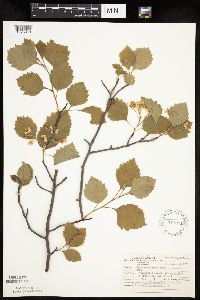 543251[1025813]Lakela, Olga; Ahlgren, Clifford 213371957-06-08 United States, Minnesota, Lake, Washington Island, Basswood Lake;Boundary Waters Canoe Area Wilderness / Superior National Forest;064N;10W;03, 48.05294 -91.59372 |
MIN:Plants | 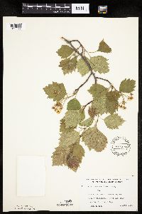 543272[1025597]Lakela, Olga 213131957-06-01 United States, Minnesota, Saint Louis, Floodwood River bank about 3 miles from the village [assuming Floodwood];;052N;20W;29, 46.96095 -92.90013 |
MIN:Plants | 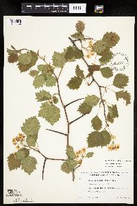 543274[1025564]Lakela, Olga 213171957-06-01 United States, Minnesota, Saint Louis, St. Louis County...Prairie River bank;;;;, 47.461021 -92.945289 |
MIN:Plants | 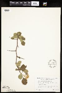 543275[1025584]Lakela, Olga 214311957-06-02 United States, Minnesota, Saint Louis, Hellwig Creek N of Canyon (S of Cotton) on hwy 53, W of the road;;N;;, 47.10191 -92.46918 |
MIN:Plants | 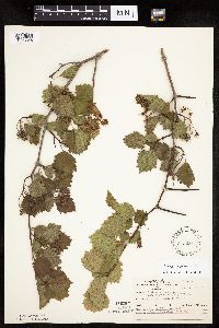 543281[1025548]Ahlgren, Clifford s.n.1957-06-12 United States, Minnesota, Lake, Basswood Lake; Camp site Island, Wind Bay.;Boundary Waters Canoe Area Wilderness / Superior National Forest;064N;10W;00, 48.01441 -91.6101 |
MIN:Plants | 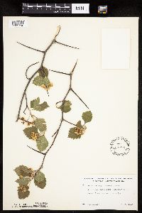 543282[1025774]Lakela, Olga 213081957-06-01 United States, Minnesota, Saint Louis, Prairie River bank near the bridge;;N;;, 46.80382 -92.98004 |
MIN:Plants | 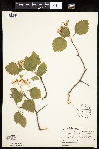 543345[1025618]Lakela, Olga; Ahlgren, Clifford 21336a1957-06-08 United States, Minnesota, Lake, Washington Island in Basswood Lake;Boundary Waters Canoe Area Wilderness / Superior National Forest;064N;10W;03, 48.05294 -91.59372 |
MIN:Plants | 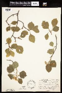 543346[1025619]Lakela, Olga; Ahlgren, Clifford 213361957-06-08 United States, Minnesota, Lake, Washington Island in Basswood Lake...Lake County;Boundary Waters Canoe Area Wilderness / Superior National Forest;064N;10W;03, 48.05294 -91.59372 |
MIN:Plants | 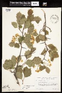 543378[1025707]Lakela, Olga 213041957-06-01 United States, Minnesota, Saint Louis, Floodwood River n. of Floodwood about 3 mi.;;052N;20W;00, 46.98261 -92.86869 |
MIN:Plants | 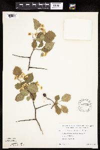 543440[1025769]Lakela, Olga 213321957-06-02 United States, Minnesota, Saint Louis, Town-line road W of hwy #5 SE of Hibbing;;N;;, 47.36906 -92.81147 |
MIN:Plants | 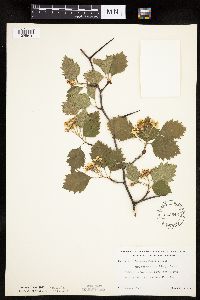 543546[1025810]Lakela, Olga 212371957-06-02 United States, Minnesota, Saint Louis, Low bank of Pale Face River N of Cotton.;;N;;, 47.18009 -92.47879 |
MIN:Plants | 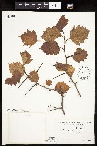 543617[1025551]Lakela, Olga 211701956-09-30 United States, Minnesota, Saint Louis, Border of Town Line Road, SE of Hibbing.;;;;, 47.36255 -92.86881 |
MIN:Plants | 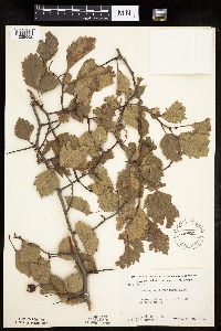 549821[1025652]Moore, John; et al. 223041954-09-22 United States, Minnesota, Lincoln, Lincoln County...west side of Lake Stay;;111N;44W;29, 44.39393 -96.17094 |
MIN:Plants | 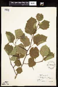 550584[1025716]Cotter, Shirley 7001948-08-00 United States, Minnesota, Clearwater, [no further data];Itasca State Park;143N;36W;00, 47.19557 -95.23322 |
MIN:Plants | 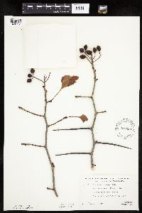 552220[1025776]Davidson, Donald 741957-10-05 United States, Minnesota, Saint Louis, Woodland Avenue, Hartley Field Blvd, Duluth.;;;;, 46.78333 -92.10639 |
MIN:Plants | 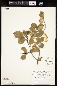 552222[1025814]Lakela, Olga 226671958-06-08 United States, Minnesota, Saint Louis, Blvd, Hartley Field on Woodland Avenue, Duluth;;N;;, 46.84611 -92.08222 |
MIN:Plants | 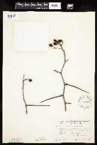 552223[1025775]Lakela, Olga 226381957-10-18 United States, Minnesota, Saint Louis, Overlooking Hartley Field on Woodland Avenue, Duluth.;;N;;, 46.78333 -92.10639 |
MIN:Plants | 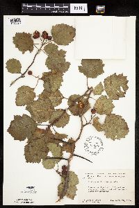 553838[1025690]Moore, John; et al. 223871954-09-23 United States, Minnesota, Pipestone, Pipestone Creek;Pipestone National Monument;106N;46W;01, 44.01585 -96.31767 |
MIN:Plants | 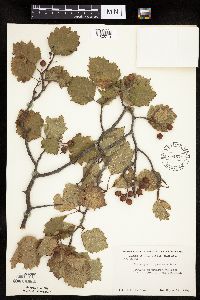 554671[1025719]Moore, John 230411956-09-14 United States, Minnesota, Clay, 1 mile south of Manitoba Jctn.;;;;, 46.89023 -96.24813 |
MIN:Plants | 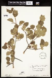 566542[1025595]Moore, John 238621958-06-12 United States, Minnesota, Kittson, Kittson County...on bank of Two Rivers, 8 mi. W of Hallock.;;;;, 48.77769 -97.1521 |
MIN:Plants | 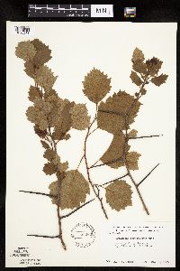 566569[1025573]Moore, John 239561958-06-16 United States, Minnesota, Kittson, Kittson County...river 1-1/2 miles north of Hallock;;161N;49W;00, 48.76042 -96.99613 |
MIN:Plants | 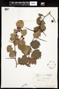 568329[1025645]Moore, John 252781960-09-21 United States, Minnesota, Anoka, Anoka County...1/2 mi. west of Fish Lake.;Cedar Creek National History Area;034N;23W;26, 45.4069 -93.17315 |
MIN:Plants | 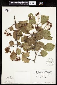 585665[1025504]Moore, John 260701962-06-27 United States, Minnesota, Kittson, Kittson County...river bank 3 miles east of Hallock;;161N;48W;00, 48.76053 -96.8649 |
MIN:Plants | 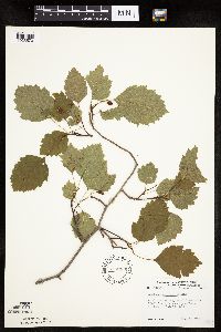 594366[1025570]Thorne, Robert 307351962-06-29 United States, Minnesota, Clearwater, Clearwater County...along Bohall Trail, Itasca State Park. S 1/2 Sec. 9 T-143N R-36W;Itasca State Park;143N;36W;09, 47.21713 -95.24447 |
MIN:Plants | 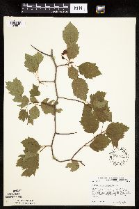 594396[1025571]Thorne, Robert 306801962-06-26 United States, Minnesota, Clearwater, Itasca State Park. Clearwater County...headwaters area of Mississippi River at N end Lake Itasca, Itasca State Park. Itasca Twp. SW 1/4 Sec. 35 T-144N R-36W. 144N 36W 35, 47.2465 -95.20158 |
MIN:Plants | 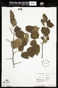 616353[1025606]Moore, John; Moore, Marjorie 3491969-07-23 United States, Minnesota, Crow Wing, Crow Wing Natural History Area. Crow Wing County. East line of N.W.1/4 Sect. 20 Garrison Twp.;Crow Wing Natural Area;044N;28W;20, 46.27965 -93.90513 |
MIN:Plants | 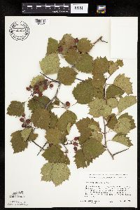 689825[1025535]Ownbey, Gerald 57841977-08-09 United States, Minnesota, Clearwater, Clearwater County...Itasca State Park. Along Bohall Trail, about 1 mi E of its terminus on the Wilderness Drive;Itasca State Park;143N;36W;09, 47.21713 -95.24447 |
MIN:Plants | 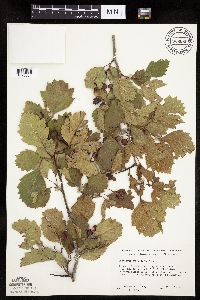 689999[1025534]Ownbey, Gerald 57201977-07-27 United States, Minnesota, Norman, Norman County...T143N, R43W, Sect. 19, SW1/4. Near Minn. Rte 113, 3.5 mi E, 0.3 mi N of Syre...N of a lake;;143N;43W;19, 47.18751 -96.18399 |
MIN:Plants | 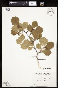 696742[1025800]Smith, Welby 8301978-06-04 United States, Minnesota, Wright, Just west of state highway 24.;;122N;27W;22, 45.364354 -94.067304 |
MIN:Plants | 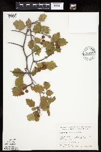 701015[1025718]Dorio, J. 7201977-08-03 United States, Minnesota, Morrison, about 3 mi NE of Camp Ripley Junction;Ripley Esker Scientific Natural Area;042N;31W;19, 46.10628 -94.30299 |
MIN:Plants | 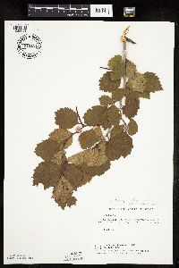 715111[1025651]Severson, M. 811979-07-30 United States, Minnesota, Polk, 4.5 mi. south of Fischer, W1/2 of NW1/4 of Sec;Malmberg Prairie Scientific Natural Area;149N;48W;16, 47.7241699 -96.8139653 |
MIN:Plants | 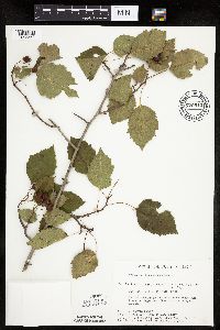 729810[1025560]Converse, C. 4291980-07-07 United States, Minnesota, Pine, Pine County...Kettle River Natural Area: 5.5 miles east of Hinckley. SE1/4 SW1/4 Sec. 15, T41N, R20W.;Kettle River Scientific Natural Area / Sandstone National Wildlife Refuge;041N;20W;15, 46.03301 -92.85662 |
MIN:Plants | 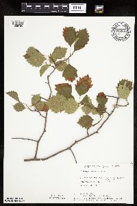 729955[1025730]Cutler, S. 681980-06-13 United States, Minnesota, Pine, 5.5 mi E of Hinckley. NW1/4 SW1/4 of Sec. ;Kettle River Scientific Natural Area / Sandstone National Wildlife Refuge;041N;20W;23, 46.01861 -92.8358 |
MIN:Plants | 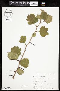 732649[1025731]Severson, M. 7371980-09-25 United States, Minnesota, Becker, 10 mi. W of Ogema. SE1/4 SW1/4 of Sec. ;Zimmerman Prairie [TNC];142N;43W;16, 47.11503 -96.14142 |
MIN:Plants | 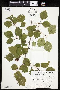 734407[1025561]Severson, M. 6231980-07-30 United States, Minnesota, Becker, Becker County...Green Water Lake Natural Area: 5 mi. W of Pondsford. NW1/4 SE1/4 Sec. 33, T141N, R38W.;Greenwater Lake Scientific Natural Area / White Earth Indian Reservation;141N;38W;33, 46.98389 -95.4977 |
MIN:Plants | 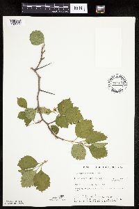 734450[1025715]Severson, M. 1481980-05-21 United States, Minnesota, Becker, 5 mi. W of Ponsford. NW1/4 SE1/4 of Sec. ;Greenwater Lake Scientific Natural Area / White Earth Indian Reservation;141N;38W;33, 46.98389 -95.4977 |
MIN:Plants | 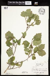 739659[1025850]Converse, C. 21131982-08-25 United States, Minnesota, Pope, Moe Woods T123N, R36W, SW1/4 SW1/4 Sec. 34.;Moe Woods, The Nature Conservancy;123N;36W;34, 45.41981 -95.18334 |
MIN:Plants | 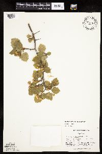 744535[1025865]Converse, C. 8481982-05-24 United States, Minnesota, Pope, Pope County ... NW1/4 NW1/4 Sec. 30. Ordway Prairie: T123N, R36;Ordway Prairie, The Nature Conservancy;123N;36W;30, 45.49177 -95.1833 |
MIN:Plants | 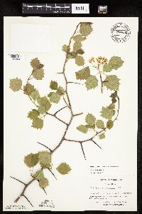 744631[1025866]Converse, C. 9041982-05-28 United States, Minnesota, Douglas, Douglas County ... Staffanson Prairie: T127N R40W NW1/4 NE1/4 and NE1/4 NW1/4 Sec. 18;Staffanson Prairie, The Nature Conservancy;127N;40W;18, 45.81067 -95.74801 |
MIN:Plants | 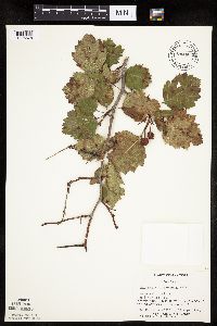 744665[1025578]Converse, C. 22951982-09-17 United States, Minnesota, Pope, Pope County...NE1/4 NW1/4 Sec. 30. Ordway Prairie: T123N R36W;Ordway Prairie, The Nature Conservancy;123N;36W;30, 45.43426 -95.24502 |
MIN:Plants | 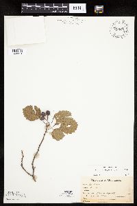 763375[1025521]Lugger, O. s.n.1900-06-24 United States, Minnesota, Saint Louis, L. Vermilion;;;;, 47.857908 -92.299611 |
MIN:Plants | 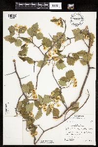 773787[1025591]Boe, J. 931979-06-11 United States, Minnesota, Lake of the Woods, Woods near outcrops. Clementson Falls;;160N;30W;12, 48.6903 -94.43922 |
MIN:Plants | 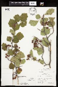 773801[1025688]Boe, J. 13871979-08-08 United States, Minnesota, Lake of the Woods, Lake of the Woods County...Clementson. Near rock outcrops at the mouth of the Rapid River. Sec. 12, R30W, T160N.;;160N;30W;12, 48.6903 -94.43922 |
MIN:Plants | 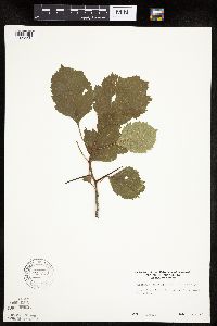 795750[1025558]Sanford, J. s.n.1947-08-02 United States, Minnesota, Clearwater, Clearwater County...Itasca State Park, East side of North arm of Itasca Lake;Itasca State Park;143N;36W;00, 47.19557 -95.23322 |
MIN:Plants | 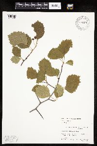 824293[1025802]Marion, J. s.n.1982-00-00 United States, Minnesota, Cook, Cook Co, North Shore of Lake Superior, ca. 200 ft. from lakeshore.;North Shore;;;, 47.46396 -91.02551 |
MIN:Plants | 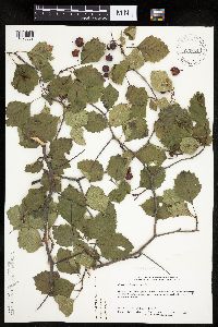 829854[1025862]Delaney, B. 913011991-09-06 United States, Minnesota, Roseau, Roseau County ... 13 mi E of Karlstad. NE1/4 SE1/4 sec.19, T159N, R43W;;159N;43W;19, 48.58166 -96.2476 |
MIN:Plants | 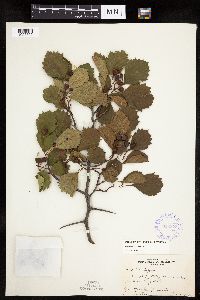 352373[1025692]Nielsen, E. 23191933-06-27 United States, Minnesota, Becker, Muensches pasture, Long Lake, Detroit Lakes.;;139N;41W;00, 46.84756 -95.85862 |
MIN:Plants | 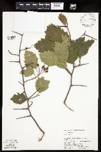 439908[1025526]Puchalski, L. 1531992-08-01 United States, Minnesota, Saint Louis, T60N R19W S29 ... Dark river ... County: St. Louis;Superior National Forest;060N;19W;29, 47.65182 -92.78557 |
MIN:Plants | 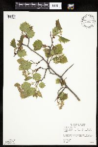 455076[1025545]Gerdes, Lynden 39352000-05-31 United States, Minnesota, Lake, North Shore / Tettegouche State Park. Lake County ... Tettegouche State Park ... north shore of Baptism River and north of the High Falls bridge ... T56N R07W S10SENW. 056N 07W 10, 47.35069 -91.2084 |
MIN:Plants | 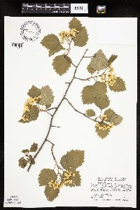 455512[1025817]Smith, Welby 277831999-05-23 United States, Minnesota, Aitkin, Aitkin County ... Along the Mississippi River near the jct of Hwys 65 and 200; about 15 miles east of Hill City ... T 52N R 23W SE1/4 of SE1/4 of Sec 9. 052N 23W 9, 47.0013885 -93.2694473 |
MIN:Plants | 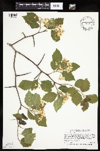 462167[1025554]Smith, Welby 266021997-06-12 United States, Minnesota, Beltrami, Beltrami County ... On the north side of Highway 71, about 3.5 miles north of its junction with Highway 2 in Bimidji [sic] ... T147N R33W SE1/4 of SE1/4 of Sec 16. 147N 33W 16, 47.541111 -94.8705521 |
MIN:Plants | 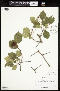 426786[1025830]Lee, Michael MDL17331997-07-03 United States, Minnesota, Stearns, Stearns Co.; 2 miles SSE of Roscoe; T122N R31W NW1/4 NE1/4 Sec. 6;;122N;31W;6, 45.40486 -94.62413 |
MIN:Plants | 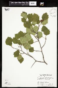 488920[1025592]Smith, Welby 274031998-07-20 United States, Minnesota, Anoka, Pioneer Path Park, in the city of Blaine. SE1/4 of SE1/4 of Sec.;;031N;23W;04, 45.1991667 -93.2075 |
MIN:Plants | 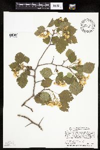 475261[1025759]Smith, Welby 277611999-05-22 United States, Minnesota, Wadena, Wadena County ... Along the Partridge River, about 3 miles NW of Staples ... T 134N R 33W SE1/4 of NW1/4 of Sec 15;;134N;33W;15, 46.4199982 -94.8319473 |
MIN:Plants | 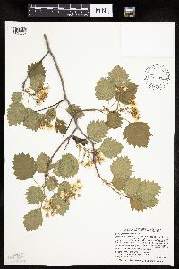 489453[1025837]Smith, Welby 277791999-05-23 United States, Minnesota, Cass, Cass County ... On the north side of Hwy 7, about 3 miles east of Longville ... T 141N R 27W SE1/4 of SE1/4 of Sec 31;Chippewa National Forest;141N;27W;31, 46.9777794 -94.1363907 |
MIN:Plants | 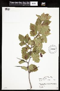 905459[1025687]Gerdes, Lynden 46302002-09-23 United States, Minnesota, Lake, Superior National Forest. T57N R10W S32NWSE. Lake County...Jordan [sic - MN Historical Society records indicates this pioneer town proabably ] occurred near Jordan/Fall Lake in T64N R8W]. 053N 14W 20, 47.37959 -91.63045 |
MIN:Plants | 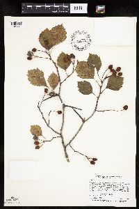 462229[1025601]Smith, Welby 259381995-09-04 United States, Minnesota, Rice, Three miles N of Faribault; on the W side of Hwy 3 about 1 mile S of Jct with Co Rd 29 right-of-way of an abandoned railroad. NW1/4 SW1/4 of section.;;110N;20W;08, 44.3463889 -93.2572222 |
MIN:Plants | 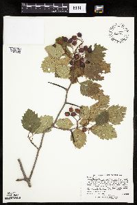 477014[1025502]Lee, Michael MDL23321998-07-31 United States, Minnesota, Crow Wing, Crow Wing County ... Along the Mississippi River at the mouth of the Nokasippi River. Fort Ripley Public Water Access off State Hwy 371 one mile north of Frot Ripley ...T43N R32W SE1/4 of NW1/4 of Sec. 23. 043N 32W 23, 46.19372 -94.34484 |
MIN:Plants | 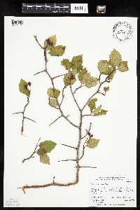 477641[1025666]Whitfeld, T.J.S. 3052001-08-22 United States, Minnesota, Kandiyohi, Kandiyohi County ... 1/2 mile east of County Rd. 115; 1-1/4 miles south of the Pope/Kandiyohi county line ... T 122 N R 36 W SW1/4 of NE1/4 of NE1/4 of Section 11. 122N 36W 11, 45.39096 -95.16278 |
MIN:Plants | 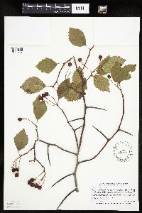 453348[1025784]Smith, Welby 268521997-09-14 United States, Minnesota, Beltrami, Buena Vista State Forest. Beltrami County ... On the north side of Highway 71, about 3.5 miles north of its junction with Highway 2 in Bimidji [sic] ... T147N R33W SE1/4 of SE1/4 of Sec 16. 147N 33W 16, 47.541111 -94.8705521 |
MIN:Plants | 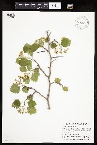 905798[1025699]Smith, Welby; et al. 293672003-05-16 United States, Minnesota, Wadena, About 4 miles southeast of Sebeka.. NE1/4 of NW1/4 of section;;136N;34W;18, 46.59377 -95.02037 |
MIN:Plants | 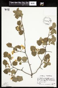 431992[1025833]Smith, Welby 265461997-05-29 United States, Minnesota, Chippewa, Chippewa County ... On the north side of Highway 212, about 0.6 mile east of where it crosses the Minnesota River in Granite Falls ... T116N R39W SW1/4 of SE1/4 of sec 34. 116N 39W 34, 44.8050003 -95.5302811 |
MIN:Plants | 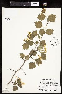 427031[1025658]Smith, Welby 256211995-05-28 United States, Minnesota, Dodge, Dodge Center Creek City Park, about one mile NW of Dodge Center. SW1/4 of SW1/4 of section SW1/4 of sec 28. 107N 17W 28, 44.0405556 -92.8780556 |
MIN:Plants | 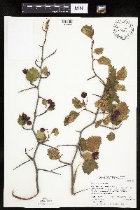 476800[1025855]Whitfeld, T.J.S. 3152001-09-04 United States, Minnesota, Kandiyohi, Burbank Wildlife Management Area. Kandiyohi County ... Burbank State Wildlife Management Area. 3 miles northeast of New London; 3/4 mile east of County Hwy. 9 ... T 122 N R 34 W SW1/4 of NE1/4 of NE1/4 of Section 35.. 122N 34W 35, 45.33335 -94.91704 |
MIN:Plants | 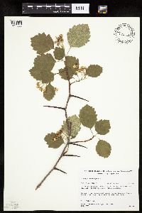 482179[1025668]Gerdes, Lynden; et al. 26301998-06-07 United States, Minnesota, Cook, Cross River area, approx. 1/8 mile SW of the Round Lake Rd (FR 320) and Gunflint Trail (Cty 12) junction.;Superior National Forest;065N;04W;27, 48.08424 -90.82544 |
MIN:Plants | 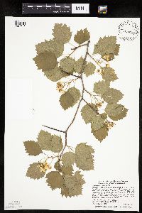 493381[1025743]Smith, Welby 277811999-05-23 United States, Minnesota, Itasca, Itasca County ... At the NW end of Leighton Lake, about 10 miles S-SW of Grand Rapids ... T 55N R 27W SE1/4 of NW1/4 of Sec 34. 055N 27W 34, 47.205555 -93.7624969 |
MIN:Plants | 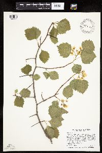 427120[1025809]Smith, Welby 256301995-05-29 United States, Minnesota, Steele, At the south-bound I35 rest stop on the Straight Rier, about 8 miles south of Owatonna. NE1/4 of SW1/4 of section;;106N;20W;17, 43.9852778 -93.2575 |
MIN:Plants | 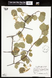 488002[1025685]Smith, Welby 271971998-06-03 United States, Minnesota, Cook, Cook County ... Temperance River State Park, about 2 miles southwest of Tofte ... T 59N R 4W SE1/4 of SE1/4 of Sec 30;North Shore / Temperance River State Park;059N;04W;30, 47.5594444 -90.8688889 |
MIN:Plants | 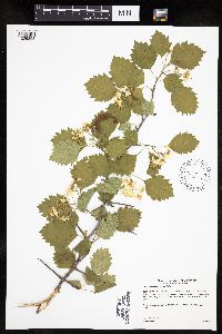 436806[1025808]Gerdes, Lynden 48402004-06-16 United States, Minnesota, Lake, Superior National Forest. T60N R10W S26SWSW Lake County ... Superior National Forest. Approximately 10.44 miles WNW of Isabella, MN. NW of the Stony River and FR spur junction along the raodside and north banks.. 060N 10W 26, 47.65405 -91.56533 |
MIN:Plants | 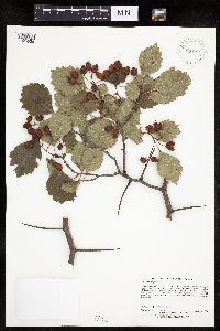 904713[1025528]Lee, Michael MDL27051999-09-07 United States, Minnesota, Lake, North Shore. Lake County...Along County Road 6 three miles east-southeast of Finland...(between Park Hill road and Finland Heritage Site)...T57N R7W SE1/4 of SE1/4 Sec. 22. 057N 07W 22, 47.40776 -91.20374 |
MIN:Plants | 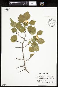 462360[1025749]Smith, Welby 241741994-05-30 United States, Minnesota, Itasca, At Bowstring Lodge; on the north side of Bowstring Lake. SW1/4 of SW1/4 of section;Chippewa National Forest;147N;25W;06, 47.5716667 -93.9030556 |
MIN:Plants | 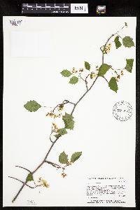 915806[1025517]Whitfeld, T.J.S. 6642006-05-24 United States, Minnesota, Hubbard, Hubbard County...1 mi east of Beauty Lake; 1/4 mile southwest of Spider Lake Forest Road...UTM (NAD83) E340723 N5224953;;143N;35W;34, 47.1588889 -95.1013889 |
MIN:Plants | 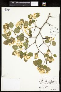 493749[1025684]Smith, Welby 284302000-05-24 United States, Minnesota, Itasca, Itasca County ... On the north side of U.S. Hwy 2, 0.8 mile SE of the Prairie River crossing ... T 55N R 25W SE1/4 of SW1/4 of Sec 25. 055N 25W 25, 47.2119446 -93.4641647 |
MIN:Plants | 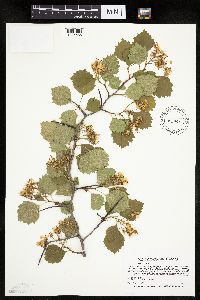 431991[1025686]Smith, Welby 265911997-06-09 United States, Minnesota, Crow Wing, Crow Wing County ... At the confluence of the Nokasippi and Mississippi Rivers, about one mile N of Fort Ripley ... T43N R32W NE1/4 of SW1/4 of Sec 27. 043N 32W 27, 46.1780548 -94.3644409 |
MIN:Plants | 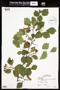 908330[1025764]Gerdes, Lynden; et al. 54962007-08-03 United States, Minnesota, Lake, Boundary Waters Canoe Area Wilderness / Superior National Forest. T62N R06W S33NESE. Lake County, MN. Superior National Forest. Hog Creek, BWCAW. Approximately 0.24 miles west of the entry point along portage.. 062N 06W 33, 47.81067 -91.097 |
MIN:Plants | 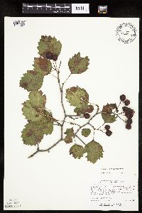 435092[1025697]Lee, Michael MDL19411997-09-08 United States, Minnesota, Stearns, Southwest side of St. Cloud. In the city limits between Hwy 15 and Co. Rd. 74 SE1/4 SE1/4 SE1/4 of Sec.;;124N;28W;29, 45.52273 -94.22961 |
MIN:Plants | 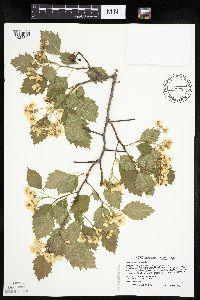 462179[1025500]Smith, Welby 266211997-06-18 United States, Minnesota, Saint Louis, St. Louis County ... On the south side of Highway 61, about 2 miles SW of the Lake-St. Louis county line ... T51N etc.;North Shore;051N;12W;02, 46.9300003 -91.8305588 |
MIN:Plants | 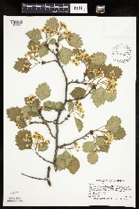 489458[1025838]Smith, Welby 265881997-06-08 United States, Minnesota, Saint Louis, St Louis County ... About 200 meters E of where the Willard Munger Trail crosses Hwy 23, on the western edge of Duluth ... T49N R15W SE1/4 of SE1/4 of Sec 32. 049N 15W 32, 46.6777763 -92.2588882 |
MIN:Plants | 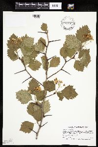 475240[1025792]Smith, Welby 266441997-06-19 United States, Minnesota, Cook, North Shore / Superior National Forest. Cook County ... On the bank of the Poplar River about 2 air miles north of its muth at Lake Superior ... T60N R3W SW1/4 of NW1/4 of Sec 21. 060N 03W 21, 47.6672211 -90.7213898 |
MIN:Plants | 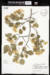 493522[1025844]Smith, Welby 277651999-05-22 United States, Minnesota, Wadena, Wadena County ... About 4.5 miles NW of Staples ... T134N R33W SW1/4 of SW1/4 of Sec 9;;134N;33W;09, 46.4286118 -94.8619461 |
MIN:Plants | 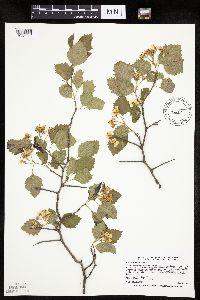 475251[1025788]Smith, Welby 266111997-06-13 United States, Minnesota, Saint Louis, St. Louis County ... About 4 miles northwest of Chisholm ... T59N R21W SW1/4 of SW1/4 of Sec 36;;059N;21W;36, 47.5463905 -92.9547195 |
Google Map
Google Maps is a web mapping service provided by Google that features a map that users can pan (by dragging the mouse) and zoom (by using the mouse wheel). Collection points are displayed as colored markers that when clicked on, displays the full information for that collection. When multiple species are queried (separated by semi-colons), different colored markers denote each individual species.