University of Minnesota
http://www.umn.edu/
612-625-5000
http://www.umn.edu/
612-625-5000
Minnesota Biodiversity Atlas
Bell Museum
Dataset: MIN-Plants
Taxa: Crataegus chrysocarpa
Search Criteria: excluding cultivated/captive occurrences
Bell Museum plants | |
 MIN:Plants | 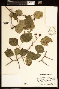 940551[1283964]Smith, Welby R. 264111996-09-11 United States, Minnesota, Wadena, Two miles NE of Staples. Along a fence row that separates the road right-of-way from a plowed field. Large open-grown shrub with more or less ascending branches NW of NE of section;;134N;32W;31, 46.3786111 -94.7680556 |
MIN:Plants | 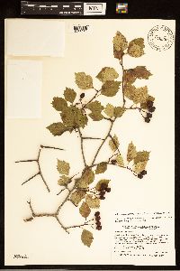 940550[1283932]Smith, Welby R. 264121996-09-11 United States, Minnesota, Wadena, About 2 miles NE of Staples. In a brushy strip between an old field and an open- canopy bur oak woodland. NW of NE of section;;134N;32W;31, 46.3786111 -94.7680556 |
MIN:Plants | 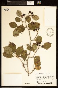 940549[1283962]Smith, Welby R. 264131996-09-11 United States, Minnesota, Wadena, The 'Old Wadena Site', 8 mi NW of Staples. An opening in dryish oak-aspen woods (bur oak, trembling aspen). A large open-grown shrub with ascending branches SW of SW of section;;134N;33W;11, 46.4313889 -94.8155556 |
MIN:Plants | 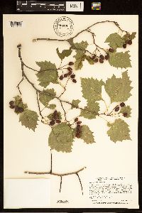 940548[1283960]Smith, Welby R. 264171996-09-11 United States, Minnesota, Wadena, About 5 miles SE of Nimrod. On the N side of County Road 139. Along the edge between a cow pasture and a bur oak woodland. A large dense multi-stemmed shrub SW of SE of section;;136N;33W;01, 46.6188889 -94.7888889 |
MIN:Plants | 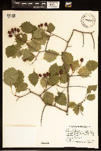 940546[1283947]Smith, Welby R. 264221996-09-11 United States, Minnesota, Wadena, About 1.5 miles W-SW of Sebeka. Along a fence row running adjacent to the south side of County Road 134. NW of NE of section;;136N;35W;08, 46.6158333 -95.1216667 |
MIN:Plants | 940545[]Smith, Welby R. 264241996-09-11 United States, Minnesota, Wadena, About 1 mile N-NW of Blue Grass. In an abandoned pasture, now being invaded by shrubs and tree saplings. A large open-grown shrub with ascending branches NE of NE of section;;136N;34W;31, 46.5577778 -95.0111111 |
MIN:Plants | 940543[]Smith, Welby R. 264261996-09-11 United States, Minnesota, Wadena, About one mile N-NW of Blue Grass. In a long-abandoned pasture now being invaded by shrubs and tree saplings. A large multi-stemmed shrub NE of NE of section;;136N;34W;31, 46.5577778 -95.0111111 |
MIN:Plants | 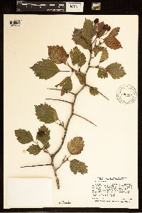 940542[1283968]Smith, Welby R. 264271996-09-11 United States, Minnesota, Wadena, In a narrow strip of deciduous trees (mostly green ash) along the northeast end of Blueberry Lake, ca 2.5 miles north of Menahga. A large multi-stemmed shrub NE of SW of section;;138N;35W;02, 46.7961111 -95.0716667 |
MIN:Plants | 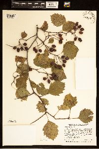 940541[1283951]Smith, Welby R. 264291996-09-12 United States, Minnesota, Wadena, Just E of the Wadena - Otter tail County line, ca 3 miles N of Wadena (town). Growing in shrub thicket along a fence row between a pasture and a plowed field SW of SW of section;;135N;35W;17, 46.5025 -95.1536111 |
MIN:Plants | 940540[]Smith, Welby R. 264321996-09-12 United States, Minnesota, Otter Tail, ca 3 mi NE of Battle Lake (town). In a narrow strip of woods along the W shore of Molly Stark Lake. A dense shrub with a single stem NW of SW of section;;133N;40W;24, 46.3177778 -95.6758333 |
MIN:Plants | 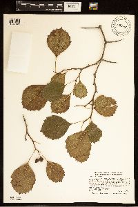 940539[1283967]Smith, Welby R. 264351996-09-14 United States, Minnesota, Scott, just SW of Burnsville. Growing at the edge of an oak-aspen forest. An unusually large specimen with several trunks from one base SE of SE of section;;114N;21W;04, 44.7061111 -93.3413889 |
MIN:Plants | 640538[]Smith, Welby R. 264391996-09-15 United States, Minnesota, Pipestone, ca 7 mi S-SW of Pipestone. In a narrow band of deciduous forest along shore shore of Split Rock Lake. Under broken canopy of green ash NW of NW of section;;105N;46W;22, 43.8916667 -96.3636111 |
MIN:Plants | 940537[]Smith, Welby R. 264421996-09-15 United States, Minnesota, Martin, At the southwest end of Bright Lake, about 8 miles southwest of Fairmont. In a narrow strip of woods between the lake and a gravel road; shaded by bur oak NW of SW of section;;101N;31W;17, 43.5494444 -94.5888889 |
MIN:Plants | 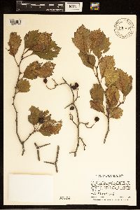 940536[1283956]Smith, Welby R. 264531996-09-17 United States, Minnesota, Scott, In the Louisville Swamp area. In a dry bedrock prairie/savanna habitat. NW of SW of section;;115N;23W;28, 44.7388889 -93.5988889 |
MIN:Plants | 940535[]Smith, Welby R. 264641996-09-24 United States, Minnesota, Olmsted, In a grassy old field on the east side of U.S. Hwy 52, about 2 miles south of Oronoco. A large, dense colony (thicket) occupying about 50 sq m SW of SE of section;;108N;14W;20, 44.1375 -92.525 |
MIN:Plants | 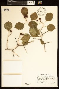 940534[1283958]Smith, Welby R. 264651996-09-24 United States, Minnesota, Mower, about 2 miles northwest of Le Roy. At the edge of a mesic deciduous forest dominated by northern pin oak and black cherry SW of NW of section;;101N;14W;21, 43.5388889 -92.5286111 |
MIN:Plants | 940533[]Smith, Welby R. 264721996-09-29 United States, Minnesota, Lake, ca 3 mi SE of Finland (town). Brushy opening in aspen-birch woodland. A multi-stemmed shrub 2.5 m tall, avg 3 cm dia NW of NW of section;;057N;07W;26, 47.3994444 -91.1908333 |
MIN:Plants | 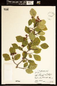 942302[1283974]Gerdes, Lynden B.; Perry, Ethan 69482013-08-21 United States, Minnesota, Saint Louis, Upper Pauness Lake approximately 11.99 miles SE of Crane Lake, MN. Near portage landing to Lower Pauness Lake on west side of portage. SWSW of section;Boundary Waters Canoe Area Wilderness / Superior National Forest;66N;15W;15, 48.192848 -92.252472 |
MIN:Plants | 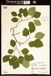 942289[1283975]Gerdes, Lynden B. 69692013-07-24 United States, Minnesota, Saint Louis, Bass Lake Trail area. Low Lake. Approximately 4.44 miles north of Ely, MN. NESE of section;Superior National Forest;63N;12W;03, 47.967091 -91.844635 |
MIN:Plants | 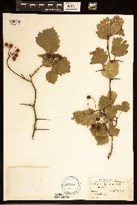 489701[1284085]Stevens, O. s.n.1917-09-26 United States, North Dakota, Cass, Fargo |
MIN:Plants | 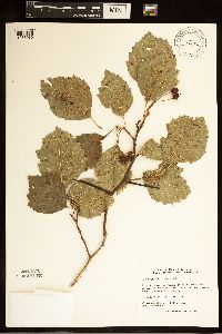 518682[1283930]Zager, Scott C. 9408231994-08-23 United States, Minnesota, Houston, In state forest lands near Yucatan. T103N R07W NE 1/4, NE 1/4, SW 1/4, 35 [Dorer Memorial Hardwood State Forest], 43.679094 -91.642666 |
MIN:Plants | 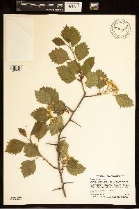 940575[1283950]Smith, Welby R. 26147A1996-06-12 United States, Minnesota, Lake, Superior National Forest. About 1/2 mile S of Flat Horn Lake. T60N R9W SE1/4 of NE1/4 of Sec 27, 47.656389 -91.453889 |
MIN:Plants | 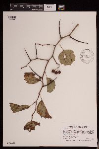 943110[1291326]Smith, Welby R. 268561997-09-15 United States, Minnesota, Cass, About 0.25 mile north of Highway 210 on Pillsbury Road, one mile northeast of Pillager. SE of NE of section.; T133N R30W sec16, 46.3375 -94.4516667 |
MIN:Plants |  943100[1291246]Smith, Welby R. 268181997-08-25 United States, Minnesota, Lake, along the Stony River, about 50 meters west of where it crosses Highway 1 NE of NE of section; T060N R10W sec28, 47.6591667 -91.6019444 |
MIN:Plants | 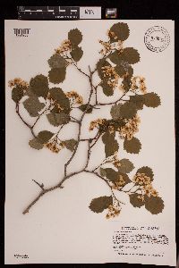 943091[1291255]Smith, Welby R. 265381997-05-27 United States, Minnesota, Washington, William O'Brien State Park. In the St. Croix Valley, about 1.5 miles north of Marine. SW of SW of section; T032N R19W sec30, 45.225 -92.76 |
MIN:Plants | 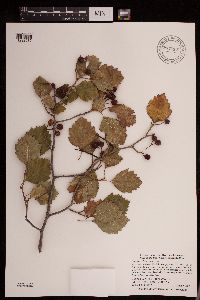 947897[1292032]Smith, Welby R. 305192007-08-09 United States, Minnesota, Big Stone, Big Stone National Wildlife Refuge, about 3.5 miles SE of Ortonville. SE of NE of section; T121N R46W sec27, 45.2627778 -96.4113889 |
MIN:Plants | 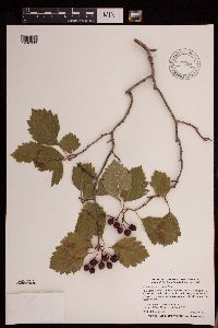 947898[1292033]Smith, Welby R. 305202007-08-09 United States, Minnesota, Big Stone, Big Stone National Wildlife Refuge, about 3.5 miles SE of Ortonville. SE of NE of section; T121N R46W sec27, 45.2627778 -96.4113889 |
MIN:Plants | 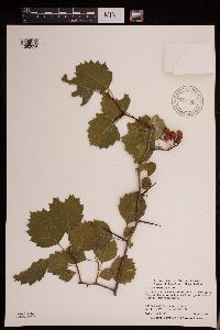 947899[1292034]Smith, Welby R. 305212007-08-09 United States, Minnesota, Big Stone, Big Stone National Wildlife Refuge, about 3.5 miles SE of Ortonville. SE of NE of section; T121N R46W sec27, 45.2627778 -96.4113889 |
MIN:Plants | 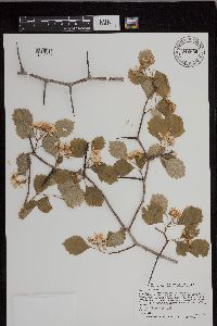 942630[1297241]Smith, Welby R. 265581997-06-01 United States, Minnesota, Fillmore |
MIN:Plants | 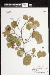 952952[1297466]Smith, Welby R. 26364 United States, Minnesota, Saint louis |
MIN:Plants | 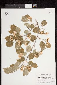 952948[1297470]Smith, Welby R. 26125 United States, Minnesota, Wadena |
MIN:Plants | 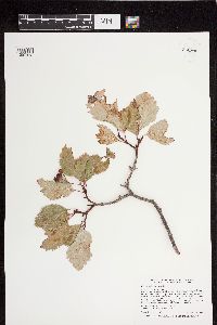 952946[1297472]Smith, Welby R. 25968 United States, Minnesota, Hubbard |
MIN:Plants | 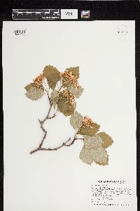 952943[1297475]Smith, Welby R. 25674 United States, Minnesota, Hubbard |
MIN:Plants | 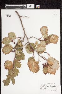 952958[1297490]Smith, Welby R. 26457 United States, Minnesota, Aitkin |
MIN:Plants | 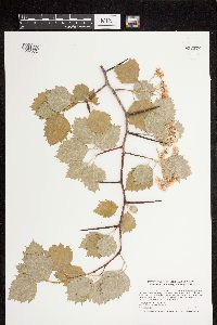 952972[1297582]Smith, Welby R. 27197 United States, Minnesota, Cook |
MIN:Plants | 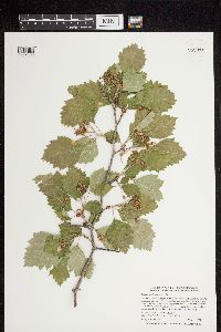 952971[1297583]Smith, Welby R. 27097 United States, Minnesota, Le sueur |
MIN:Plants | 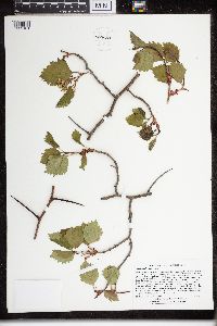 960580[1329181]Lee, Michael MDL31472002-06-06 United States, Minnesota, Lake, Along the lower reaches of Silver Creek in fairly rugged bedrock terrain 3.5 miles northeast of Two Harbors. Uncommon and local on alluvial terrace along the creek ~1/8-mile downstream from County Road 3 and ~1 mile upstream from the Lake Superior shore. S1/2 of SW1/4 of SW1/4 Sec. 16, 47.070252 -91.615959 |
MIN:Plants | 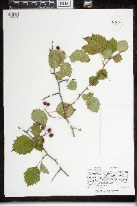 960571[1329172]Lee, Michael MDL33252002-09-18 United States, Minnesota, Carlton, Along the South Fork Nemadji River in level to locally quite rugged forested terrain 2.5 miles north-northwest of Holyoke, 16 miles east-northeast of the town of Moose Lake; ~1/3-mile upstream from the Highway 23 bridge. NE1/4 of SW1/4 Sec. 6, 46.517723 -92.389841 |
MIN:Plants | 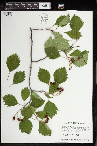 963762[1352657]Welby R Smith 356102016-07-01 United States, Minnesota, St. Louis, Near the south edge of a low, forested island in the St. Louis River, just southwest of New Duluth. SE of SE of section, 46.6513889 -92.2400556 |
MIN:Plants | 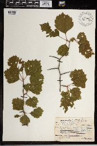 967559[1368095]Drew, L.A. s.n.1969-07-15 United States, Minnesota, Norman, 6 miles E Syre; T143N R43W sec.17 NW SW SW 1/4, 47.197327 -96.17145 |
MIN:Plants | 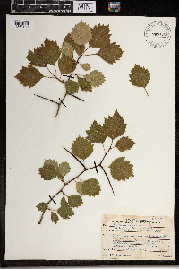 967545[1368109]Drew, L.A. s.n.1969-07-16 United States, Minnesota, Hubbard, 1 mile S Hubbard; T139N R34W sec. 29 W1/6 SE 1/4 SW 1/4, 46.82209 -95.010598 |
MIN:Plants | 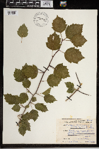 967543[1368111]Drew, L.A. s.n.1969-07-22 United States, Minnesota, Clearwater, Itasca State Park; T144N R36W sec. 36 SW SE 1/4, 47.241815 -95.182008 |
MIN:Plants | 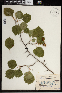 967589[1368150]Drew, L.A. s.n.1969-07-15 United States, Minnesota, Norman, 6 miles E Syre; T143N R43W sec.17 NW SW SW 1/4; 47.197327 -96.17145, 47.197327 -96.17145 |
MIN:Plants | 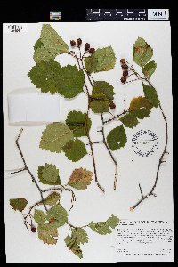 969378[1384997]Rowe, Erika R. ERR7422011-09-10 United States, Minnesota, Lake of the Woods, 48.46 -94.54 |
MIN:Plants | []Timothy J. S. Whitfeld 37092023-07-07 United States, Minnesota, Marshall, Huntley Management Area, 0.5 miles northwest of right angle turn of 130th Avenue NE, 48.45447 -96.19626, 354m |
Google Map
Google Maps is a web mapping service provided by Google that features a map that users can pan (by dragging the mouse) and zoom (by using the mouse wheel). Collection points are displayed as colored markers that when clicked on, displays the full information for that collection. When multiple species are queried (separated by semi-colons), different colored markers denote each individual species.