University of Minnesota
http://www.umn.edu/
612-625-5000
http://www.umn.edu/
612-625-5000
Minnesota Biodiversity Atlas
Bell Museum
Dataset: MIN-Plants
Taxa: Lonicera
Search Criteria: excluding cultivated/captive occurrences
Bell Museum plants | |
 MIN:Plants | Lonicera x bella Zabel 930184[]Smith, Welby 159501989-07-31 United States, Minnesota, Kanabec, Ann Lake Wildlife Management Area. N side of Ann Lake, about 5 mi NW of Mora. SW1/4 of NE1/4 of section, 45.925 -93.3772222 |
MIN:Plants | 931182[]Gerdes, Lynden B.; Walewski, Joe W. 62632011-06-16 United States, Minnesota, Lake, Superior National Forest. West end Topaz Lake. Approximately 0.30 miles NNW of the portage between Amoeber Lake and Topaz Lake. SWNWSENW. 065N 06W 8, 48.13 -91.1344444 |
MIN:Plants | Lonicera oblongifolia (Goldie) Hooker 930655[]Gerdes, Lynden B. 60782010-07-07 United States, Minnesota, Lake, Approximately 14.12 miles NW of Isabella, MN. Small wetlands between Shamrock Lake and Starling Lake. NE1/4 of SW1/4 of section;Superior National Forest;061N;10W;33, 47.7236111 -91.6113889 |
MIN:Plants | Lonicera oblongifolia (Goldie) Hooker 930707[]Gerdes, Lynden B. 60022010-06-10 United States, Minnesota, Lake, Approximately 0.98 miles SW of August Lake and 0.26 miles west of Highway 1. SESWSE of section;Superior National Forest;061N;10W;19, 47.7480556 -91.6475 |
MIN:Plants | 930731[]Gerdes, Lynden B. 59742010-05-26 United States, Minnesota, Cook, Magnetic Rock Hiking Trail area. Approximately 0.28 miles east of the Gunflint Trail. NWSWSESE of section;Superior National Forest;065N;04W;22, 48.0930556 -90.82 |
MIN:Plants | 930735[]Gerdes, Lynden B. 59702010-05-17 United States, Minnesota, Lake, Approximately 14.65 miles northwest of Isabella, MN and 0.81 miles south of August Lake. SWSESESE of section;Superior National Forest;061N;10W;21, 47.7480556 -91.6 |
MIN:Plants | 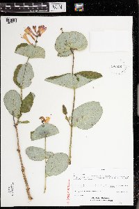 933822[1397625]Pomroy, Deborah; Barnes, Raymond DLP27882012-07-11 United States, Minnesota, Lake, Two Harbors. Third St. gate of water treatment plant, N of Two Harbors Lake Walk. UTM: 15 601474E, 5207714N. Two Harbors Quadrangle. NW1/4 of SW1/4 of section.;<No data>;052N;11W;06, 47.0169444 -91.6647222 |
MIN:Plants | Lonicera villosa NULL 934099[]Smith, Welby R. 33451 United States, Minnesota, Koochiching, About 20 miles N-NE of Waskish. SE of SE of section;Pine Island State Forest;156N;29W;03, 48.3543 -94.3433667 |
MIN:Plants | 931678[]Smith, Welby R. 202481992-05-20 United States, Minnesota, Marshall, about 11 miles east of Argyle NW of SE of section;Old Mill State Park;156N;46W;04, 48.3602778 -96.5702778 |
MIN:Plants | Lonicera villosa NULL 932286[]Lee, Michael MDL45782008-06-04 United States, Minnesota, Cass, In the headwaters of Little Swamp Creek, 6.5 miles northeast of Nimrod. W1/2 of SW1/4 of NE1/4 of section;;137N;32W;07, 46.6972172 -94.7751101 |
MIN:Plants | Lonicera oblongifolia (Goldie) Hooker 932689[]Lee, Michael MDL46382008-06-25 United States, Minnesota, Wadena, East of U.S. Highway 71, three miles south of Menahga. East of the old Burlington Northern railroad grade. NE1/4 of SW1/4 of SE1/4 of section;;137N;35W;03, 46.7063284 -95.087267 |
MIN:Plants | Lonicera morrowii A. Gray 932722[]Lee, Michael; Rowe, Erika MDL47012008-07-15 United States, Minnesota, Hubbard, Along the Fishhook River ~1.5 miles south of the State Highway 34 bridge in Park Rapids. SW1/4 of NW1/4 of section;;140N;35W;36, 46.8976212 -95.0503975 |
MIN:Plants | 931660[]Smith, Welby R. 201981992-05-20 United States, Minnesota, Pennington, On the east bank of the Red Lake River, just across the river (southeast) from St. Hilare SE of SE of section;;152N;43W;06, 48.0072222 -96.2011111 |
MIN:Plants | Lonicera x bella Zabel 931664[]Smith, Welby R. 202031992-05-20 United States, Minnesota, Pennington, On the east bank of the Red Lake River, just across the river (southeast) from St. Hilare SE of SE of section. T152N;R43W;SE1/4 of SE1/4 of Sec 6, 48.0072222 -96.2011111 |
MIN:Plants | Lonicera morrowii A. Gray 931680[]Smith, Welby R. 202601992-05-21 United States, Minnesota, Polk, On the north side of Maple Lake, about 2 miles south of Mentor NW of SE of section;;148N;43W;05, 47.6638889 -96.1563889 |
MIN:Plants | Lonicera hirsuta Eaton 931776[]Smith, Welby R. 204511992-06-20 United States, Minnesota, Wadena, On the north side of a gravel road, about one mile west of Manahga SE of NE of section;;138N;35W;20, 46.7547222 -95.1216667 |
MIN:Plants | Lonicera morrowii A. Gray 933506[]Smith, Welby R. 205231992-06-24 United States, Minnesota, Brown, Flandrau State Park. On the south side of New Ulm in the Cottonwood River Valley. T110N;R30W; NW1/4 of SE1/4 of section 32, 44.2875 -94.4608333 |
MIN:Plants | 934267[]Partch, M. s.n.1957-05-03 United States, Minnesota, Kandiyohi, Mud Lake Huron Colony, Island 2, north of New London.;<No data>;121N;34W;, 45.282291 -94.947684 |
MIN:Plants | Lonicera utahensis S. Watson 905776[]Nash, A. 43081965-07-12 United States, Wyoming, Park, Clematis Gulch;Yellowstone National Park |
MIN:Plants | Lonicera hirsuta Eaton 936303[]Smith, Welby R; Morantes, Andres 328722011-06-26 United States, Minnesota, Beltrami, about 11 miles southeast of Fourtown. NW of SE of section;Red Lake State Wildlife Management Area;155N;35W;14, 48.24345 -95.1069667 |
MIN:Plants | Lonicera morrowii A. Gray 936033[]Smith, Welby R. 323762011-05-28 United States, Minnesota, Dakota, about 10 miles W-SW of Hastings. NE of SE of section;Vermillion Highlands State Wildlife Management Are;114N;19W;13, 44.67855 -93.0380667 |
MIN:Plants | Lonicera oblongifolia (Goldie) Hooker 936245[]Smith, Welby R. 327872011-06-24 United States, Minnesota, Beltrami, About 10 miles southeast of Fourtown, NW of NW of section;Red Lake Indian Reservation;154N;35W;08, 48.1783333 -95.1783333 |
MIN:Plants | Lonicera oblongifolia (Goldie) Hooker 936596[]Smith, Welby R.; et al. 300572007-06-13 United States, Minnesota, Itasca, About 2 miles north-northwest of Swan River (town). SW of SW of section;;053N;22W;06, 47.0998111 -93.1849152 |
MIN:Plants | 937011[]Smith, Welby R. 302942007-07-12 United States, Minnesota, Beltrami, About 2 miles west of Four Town on Hwy 89. SW of SW of section;;156N;37W;35, 48.283528 -95.3751462 |
MIN:Plants | Lonicera bella NULL 97812[]Smith, Welby R. 295282006-05-04 United States, Minnesota, Rock, Private property immediately south of Mulder State Wildlife Management Area, about 3 miles south of Luverne. SE of SE of section;Mulder Wildlife Management Area;102N;45W;26, 43.6041309 -96.1966851 |
MIN:Plants | Lonicera hirsuta Eaton 939595[]Smith, Welby R. 317202010-06-17 United States, Minnesota, Itasca, On the south side of Highway 1, about 6 miles west of Effie. NW of NW of section;;062N;27W;26, 47.8379826 -93.7640583 |
MIN:Plants | 937552[]Gerdes, Lynden B. 64902012-05-30 United States, Minnesota, Saint Louis, Babbitt, MN. Approximately 3.40 miles ESE of Babbitt, MN between the roadside shoulder of FR 178 and the Dunka River.;;060N;12W;09, 47.6975 -91.868056 |
MIN:Plants | Lonicera oblongifolia (Goldie) Hooker 937561[]Gerdes, Lynden B. 65012012-06-04 United States, Minnesota, Lake, Ojibway Lake. Approximately 13.5 miles NNE of Ely, MN. Vicinity of boat landing.;Superior National Forest;063N;10W;11, 47.955556 -91.5625 |
MIN:Plants | Lonicera hirsuta Eaton 226261[]Smith, Welby R.; Gerdes, Lynden B. 318022010-06-29 United States, Minnesota, Cook, Just south of Skipper Lake. NW of SE of section;Boundary Waters Canoe Area Wilderness / Superior National Forest;064N;02W;08, 48.0372182 -90.6037211 |
MIN:Plants | 68632[]Smith, Welby R. 320632010-08-27 United States, Minnesota, Saint Louis, About 0.5 mile east of Kitzville. NW of NE of section;;057N;20W;04, 47.4509351 -92.8787085 |
MIN:Plants | Lonicera x bella Zabel 447822[]Ruby, Janeen 212012-06-25 United States, Minnesota, Jackson, About 10 mi S of Lakefield on State Hwy 86. State property at corner of Cty Hwy 4. and Hwy 86. Along access road, abouot 100 m E of parking lot near NW corner of WMA. SW1/4 of NW1/4 of section;Sangl Wildlife Management Area;101N;36W;21, 43.53863 -95.17395 |
MIN:Plants | 941658[]Smith, Welby R. 315432010-05-25 United States, Minnesota, Aitkin, About a half mile east of Dam Lake, and 3 miles south of the town of Kimberly. NW of NE of section;;047N;25W;36, 46.5169551 -93.4387279 |
MIN:Plants | Lonicera oblongifolia (Goldie) Hooker 942357[]Gerdes, Lynden B. 68592013-07-23 United States, Minnesota, Lake, Stony River approximately 7.96 miles east of Babbitt, MN and 0.13 miles west of river. SWSW of section;Superior National Forest;60N;11W;05, 47.602641 -91.468935 |
MIN:Plants | Lonicera x bella Zabel 944863[]Nee, M. 611902014-06-10 United States, Wisconsin, Polk, Rest area, junction hwy 35 and hwy. 8, 7.6 km E of Hwy. 8 bridge over the St. Croix River at St. Croix Falls. T34N, R18W, SW1/4SE1/4 sect. 26 [St. Croix National Riverway], 45.398611 -92.555833, 354m |
MIN:Plants | Lonicera morrowii A. Gray 947449[]Nee, M. 611632014-06-09 United States, Wisconsin, Polk, Lions Park, along St. Croix River 1.8 km N (upstream) from power dam on St. Croix River at St. Croix Falls. T34N, R18W, SW1/4 sect. 18 [St. Croix National Riverway], 45.428611 -92.646667, 234m |
MIN:Plants | 392789[]Anderson, Derek S. 22882014-06-15 United States, Minnesota, Pennington, Higinbotham Wildlife Management Area, approximately 6.5km southwest of St. Hilaire. From County Road 15, then 800 meters west on County Road 54. T152N R44W SW1/4 of SE1/4 Sec. 09, 47.992584 -96.298144 |
MIN:Plants | 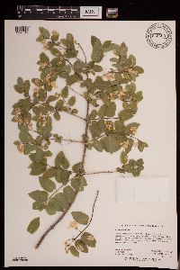 Lonicera x bella Zabel 943352[1290019]Holmstrom, Rebecca RMH #02202013-06-13 United States, Minnesota, Saint Louis, Soudan Underground Mine State Park. 2.5 km northwest of Soudan on upland finger between Swedetown Bay and Stuntz Bay.; T062N R15W sec21, 47.83371 -92.25731 |
MIN:Plants | 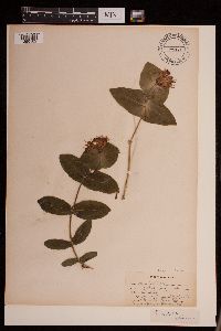 479781[1290102]Rummels, Amy s.n.1896-05-16 United States, Minnesota, Goodhue, Zumbrota [T110N;R15W;S31], 44.294132 -92.669081 |
MIN:Plants | 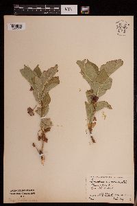 Lonicera involucrata (Richardson) Banks ex C.P.J. Sprengel 952587[1290297]Stork, H.E. 32061927-00-00 United States, Wyoming, Park, Yellowstone National Park. Mammoth Hot Springs. |
MIN:Plants | 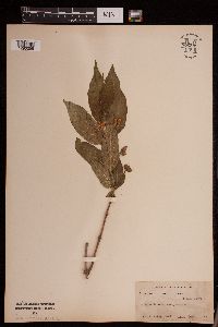 Lonicera utahensis S. Watson 952599[1290295]Stork, H.E. s.n.1923-07-00 United States, Montana, Glacier National Park |
MIN:Plants | 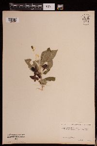 Lonicera utahensis S. Watson 952598[1290296]Lampen, D. s.n.1923-08-00 United States, Montana, Glacier National Park |
MIN:Plants | 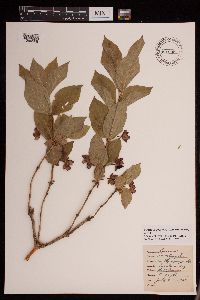 Lonicera involucrata (Richardson) Banks ex C.P.J. Sprengel 951995[1290308]Lawrence, D. B. 41930-07-23 United States, Colorado, Gunnison, Gothic. Rocky Mountain Biological Station., 2957m |
MIN:Plants | 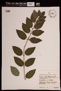 953089[1291706]Gernes, Carole J. 72014-08-29 United States, Minnesota, Washington, City of Woodbury. Shawnee Park, west side of Battle Creek Lake NE of intersection of lakeside trail and trail to fishing pier; east of small Meadow Lane Parking area., 44.941345 -92.974 |
MIN:Plants |  952585[1291754]Stork, H.E. United States, Minnesota, Goodhue |
MIN:Plants | 952578[1292255]Harrigan, A. s.n.1924-06-00 United States, Minnesota, Saint Louis, Greaney, 47.967145 -93.021006 |
MIN:Plants | 952577[1292256]Kramer, Leona s.n.1927-00-00 United States, Minnesota, Mower, [no further data], 43.67147 -92.752514 |
MIN:Plants | Lonicera dioica var. glaucescens (Rydberg) Butters 952575[1292257]Kaliher, Earl L. s.n.1927-00-00 United States, Minnesota, Todd, [no further data], 46.070624 -94.897599 |
MIN:Plants |  Lonicera involucrata (Richardson) Banks ex C.P.J. Sprengel 952586[1292280]Stork, H. E. s.n.1936-08-10 United States, Wyoming, Park, Lupine Creek, Yellowstone National Park |
MIN:Plants |  Lonicera caerulea var. villosa (Michaux) Torrey & A. Gray 952579[1292262]Stork, H. E. s.n.1925-07-00 United States, Minnesota, Itasca, Bowstring [Chippewa National Forest], 47.537188 -93.905046 |
MIN:Plants |  Lonicera reticulata Raf. 952582[1292261]Kaliher, Earl L. s.n.1927-00-00 United States, Minnesota, Todd, [no further data], 46.070624 -94.897599 |
MIN:Plants |  Lonicera hirsuta Eaton 952581[1292260]Stork, H. E. s.n.1925-00-00 United States, Minnesota, Itasca, Bowstring [Chippewa National Forest], 47.537188 -93.905046 |
MIN:Plants |  Lonicera hirsuta Eaton 952580[1292259]Stork, H. E. s.n.1925-00-00 United States, Minnesota, Itasca, Bowstring [Chippewa National Forest], 47.537188 -93.905046 |
MIN:Plants |  Lonicera dioica var. glaucescens (Rydberg) Butters 952576[1292258]Kramer, Leona s.n.1927-00-00 United States, Minnesota, Mower, [no further data], 43.67147 -92.752514 |
MIN:Plants |  Lonicera villosa (Michx.) Schult. 938692[1292854]Kerns, Courtney CKK00492013-06-26 United States, Minnesota, Lake of the Woods, 48.56495 -94.771614, 361m |
MIN:Plants | 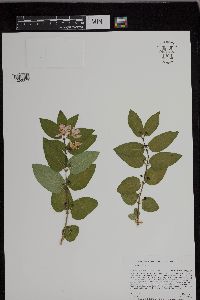 Lonicera x bella Zabel 953168[1296376]Lee, Jeffrey G. 1512016-06-13 United States, Minnesota, Saint Louis |
MIN:Plants | 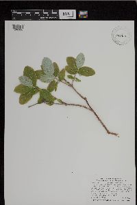 Lonicera dioica var. glaucescens (Rydberg) Butters 943430[1296900]Smith, Welby R. 339442012-07-10 United States, Minnesota, Goodhue |
MIN:Plants | 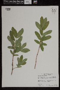 Lonicera caerulea var. villosa (Michaux) Torrey & A. Gray 958801[1305038]Lynden B. Gerdes 70012014-06-05 United States, Minnesota, Koochiching, Koochiching State Forest. Approximately 3.13 miles ESE of Big Falls, MN and 0.11 miles SW of County Road 31., 48.18861111 -93.73833333 |
MIN:Plants | 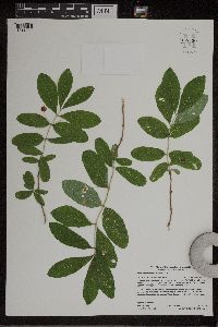 Lonicera oblongifolia (Goldie) Hooker 959390[1311221]Lynden B. Gerdes 73032015-07-22 United States, Minnesota, Saint Louis, Superior National Forest. Approximately 15.71 miles ESE of Ray, MN, then southeast off Cty. 129 (Ash River Trail) onto newly built road going to state research facility; 0.09 miles south off this unnamed road., 48.37222222 -92.86611111 |
MIN:Plants |  Lonicera caerulea var. villosa (Michaux) Torrey & A. Gray 959839[1318135]Anderson, Chel E. 24952018-07-30 United States, Minnesota, Koochiching, From International Falls, MN, west 39 mi. on Hwy 11. South 2.7 mi. on Koochiching Cty Rd. 84. West .6 mi. thru swamp., 48.59 -93.98, 351m |
MIN:Plants |  960619[1329223]Lee, Michael MDL33292002-09-18 United States, Minnesota, Carlton, Along the lower reaches of Otter Creek in fairly rugged bedrock terrain south of the Thomson Reservoir, ~halfway between Carlton and Thomson; ~1/4-mile upstream from the St. Louis River. N1/2 of NE1/4 of NE1/4 Sec. 7, Jay Cooke State Park, 46.659252 -92.418536 |
MIN:Plants |  0968483[1368024]T. J. S. Whitfeld 20872019-06-14 United States, Minnesota, Lake, Boundary Waters Canoe Area Wilderness, southern end of Lake Insula in the area burned during 2011 Pagami Creek Fire, 47.901361 -91.2845, 454m |
MIN:Plants |  963014[1346634]Whitfeld, T.J.S. 23122019-06-28 United States, Minnesota, Crow Wing, US Army Corps of Engineers Gull Lake Recreation Area, 46.411821 -94.357081 |
MIN:Plants |  Lonicera canadensis W. Bartram ex Marshall 968008[1368568]T. J. S. Whitfeld 21692019-06-17 United States, Minnesota, Lake, Boundary Waters Canoe Area Wilderness, northeast part of Alice Lake, 47.947108 -91.208844, 472m |
MIN:Plants |  Lonicera villosa (Michx.) Schult. 0967527[1368056]T. J. S. Whitfeld 21952019-06-19 United States, Minnesota, Lake, Boundary Waters Canoe Area Wilderness, in channel exiting from northeast of Insula Lake, towards Alice Lake, 47.933417 -91.260694, 464m |
MIN:Plants |  Lonicera oblongifolia (Goldie) Hooker 968019[1368582]T. J. S. Whitfeld 22042019-06-19 United States, Minnesota, Lake, Boundary Waters Canoe Area Wilderness, Island 0.1 miles south of Fish Dance Lake pictographs, 47.918917 -91.195583, 464m |
MIN:Plants |  Lonicera x bella Zabel 966302[1359141]T. J. S. Whitfeld 25292020-06-03 United States, Minnesota, Washington, Lost Valley Prairie Scientific and Natural Area, 2 miles east north east of intersection of State Highway 95 and 110th Street, at dead-end of Nyberg Avenue South., 44.797981 -92.826076, 275m |
MIN:Plants |  Lonicera maackii (Rupr.) Maxim. 963464[1352015]Nee, M. 632702016-09-15 United States, Wisconsin, Grant, Wyalusing State Park; Wyalusing Hardwood Forest State Natural Area, 42.991667 -91.098056, 312m |
MIN:Plants |  963518[1348872]Nee, M. H. 634792017-04-28 United States, Wisconsin, Grant, Woodman Sand Prairie; Dead Lake State Natural Area; along E road, 43.101111 -90.791944, 200m |
MIN:Plants |  Lonicera canadensis W. Bartram ex Marshall 963513[1348877]Nee, M. H. 635362017-05-23 United States, Minnesota, Cook, Superior National Forest; 6.8km N of Tofte (by air); Forest Road 1206 above the Temperance River, 47.664968 -90.817502, 392m |
MIN:Plants |  Lonicera maackii (Rupr.) Maxim. 963490[1348900]Nee, M. H. 638622017-08-16 United States, Wisconsin, Vernon, 5.5km S of Stoddard; scenic overlook and picnic area top of Mississippi River bluff, 47.716389 -90.860278, 295m |
MIN:Plants |  Lonicera morrowii A. Gray 964741[1375689]Lee, Michael MDL49652009-06-29 United States, Minnesota, Sherburne, George Friedrich Park, On the southeast side of St. Cloud. T35N R30W NE1/4 of SE1/4 of SW1/4 Sec. 6, NW1/4 of SW1/4 of SE1/4 Sec. 6, 45.54699304 -94.12062643 |
MIN:Plants |  Lonicera canadensis W. Bartram ex Marshall 965633[1356491]H.E. Ahles 853811978-06-24 United States, Vermont, Windham, Granville Gulf |
MIN:Plants |  Lonicera morrowii A. Gray 966075[1356835]Sister St. Mark 1933-00-00 United States, Minnesota, Ramsey |
MIN:Plants |  966076[1356836]Sister St. Mark 1933-00-00 United States, Minnesota, Ramsey |
MIN:Plants |  Lonicera japonica Thunb. 966077[1356837] 1944-07-24 United States, District of Columbia, Washington Retreat House grounds, 4000 Harewood Road |
MIN:Plants |  967229[1359888]Rowe, Erika R. ERR7002010-07-13 United States, Minnesota, Beltrami, 100 meters north of Beltrami County Hwy 22; 1 mile west of Pinewood., 47.6 -95.15 |
MIN:Plants |  0967942[1368499]F.W. Bieberdorf s.n.1940-00-00 United States, Wyoming, Yellowstone Park |
MIN:Plants | Lonicera morrowii A. Gray MPCA_Dummy20[]Mark Gernes 2021-08-23 United States, Minnesota, Chisago, St. Croix Nat. Scenic River, Collected as part of the US Environmental Protection Agency National Wetland Condition Assessment (EPA siteID NWC21-MN-10001) and MN Pollution Control Agency MN Wetland Condition Assessment (MPCA siteID 16CHIS211), 45.44573817 -92.65208819 |
MIN:Plants |  Lonicera x heckrottii Rehder 0968723[1391321]Hinds, R. s.n.1938-03-31 United States, Texas, College St. [Station] |
MIN:Plants | 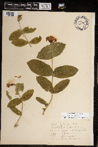 968851[1391526]Gammon, Inaz 1903-07-15 United States, Minnesota, Hennepin, 44.903296 -93.566346 |
MIN:Plants | Lonicera morrowii A. Gray []Timothy J. S. Whitfeld 31502022-06-03 United States, Minnesota, Washington, Crystal Spring Scientific and Natural Area, 0.4 miles northeast of the intersection of Scandia Trail North and Hwy 95, 45.262676 -92.768009, 287m |
MIN:Plants | Lonicera x bella Zabel []Timothy J. S. Whitfeld 31512022-06-03 United States, Minnesota, Washington, Crystal Spring Scientific and Natural Area, 0.4 miles northeast of the intersection of Scandia Trail North and Hwy 95, 45.262676 -92.768009, 287m |
MIN:Plants | []Timothy J. S. Whitfeld 31692022-06-03 United States, Minnesota, Washington, Crystal Spring Scientific and Natural Area, 0.4 miles northeast of the intersection of Scandia Trail North and Hwy 95, 45.26226 -92.765461, 270m |
MIN:Plants | 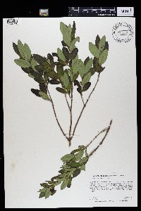 Lonicera oblongifolia (Goldie) Hooker 969379[1384998]Rowe, Erika R. ERR7672011-08-04 United States, Minnesota, Lake of the Woods, Lake of the Woods State Forest. 1 mile west of MN Trunk Hwy 72; 15 miles north of Waskish., 48.37 -94.58 |
MIN:Plants | 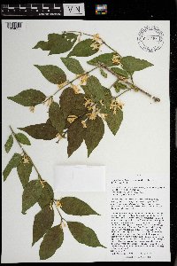 Lonicera maackii (Rupr.) Maxim. 971163[1394635;1394636]Nee, M.H. 649952019-06-02 United States, Wisconsin, Richland, Button Bluff, NE of Button Cemetery along Hwy. JJ, 3.8 km E of Gotham., 43.219722 -90.243889, 260m |
MIN:Plants | 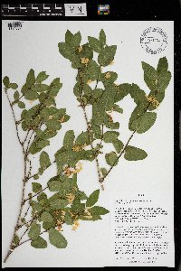 Lonicera morrowii A. Gray 971164[1394637]Nee, M.H. 649572019-05-30 United States, Wisconsin, Vernon, 6.2 km (air) NE of Readstown, along floodplain of Elk Creek (and of Kickapoo River), 0.4 km (air) upstream and NE from confluence with Kickapoo River, S of Hwy. U and W of East River Road., 43.468056 -90.690278 |
MIN:Plants |  971269[1394746]M. H. Nee 658302020-06-24 United States, Wisconsin, Oneida, 17 km (straight line) WNW of Heafford Junction, along Village Road and Little Somo River. T 36 N; R 4 E; SW¼SE¼ sect. 24, 45.5875 -89.926944, 465m |
MIN:Plants |  Lonicera maackii (Rupr.) Maxim. 971267[1394744]M. H. Nee 656292020-05-31 United States, Wisconsin, Grant, Wyalusing State Park, Hardwood Forest State Natural Area. T 6 N; R 6 W; SW¼SW ¼ sect. 16., 42.99 -91.095556, 300m |
MIN:Plants |  Lonicera morrowii A. Gray 971310[1394787]M. H. Nee 656492020-06-04 United States, Wisconsin, Vernon, 7 km NE of Westby, Jersey Valley County Park, valley of West Fork of the Kickapoo River, downstream from Peaceful Valley Road. T 14 N; R 3 W. SW¼SW¼ sect. 7., 43.698611 -90.788889, 333m |
MIN:Plants |  Lonicera morrowii A. Gray 971309[1394786]M. H. Nee 656642020-06-04 United States, Wisconsin, Vernon, NE-facing slope above Jersey Valley Lake (now empty after failure of the dam on 28 Aug. 2018), above parking area for former beach. T 14 N; R 4 W; SE¼NW ¼ sect. 13., 43.690278 -90.800556, 355m |
MIN:Plants |  971886[1395721]Janssens, J. 2061974-06-10 Belgium |
MIN:Plants |  971885[1395720]Janssens, J. 76/841976-06-13 Belgium, Doornendijk. IFBL: C3 13 31 |
MIN:Plants |  972384[1395934]Janssens, J. 75/3711975-08-01 United Kingdom, Scotland, Isle of Skye, Rubha Garbhaig (Staffin Bay) |
MIN:Plants |  973588[1397142]Lee, Michael MDL55912011-06-15 United States, Minnesota, Lake, Along the Snowbank Hiking Trail in strongly rolling bedrock terrain on the west side of Snowbank Lake, 19 miles east-northeast of Ely., 47.99222479 -91.4556772, 442m |
MIN:Plants |  973031[1398584]Lee, Michael MDL58562012-05-30 United States, Minnesota, Lake, Boundary Waters Canoe Area Wilderness; On the shores of Moose Lake in rugged bedrock terrain 17 miles east-northeast of Ely. Local on the northernmost island in Section 28., 47.9986625403 -91.4959759599, 411m |
MIN:Plants |  Lonicera oblongifolia (Goldie) Hooker 973004[1398557]Lee, Michael MDL59702012-07-03 United States, Minnesota, Lake, Boundary Waters Canoe Area Wilderness; Rolling bedrock terrain northeast of Fall Lake, nine miles northeast of Ely; on the south side of Mud Lake., 47.9720248233 -91.6644091419, 408m |
MIN:Plants |  Lonicera oblongifolia (Goldie) Hooker 973017[1398570]Lee, Michael MDL60272012-07-21 United States, Minnesota, Lake, Boundary Waters Canoe Area Wilderness; Fairly rugged bedrock terrain between Wind and Moose Lakes, 16 miles northeast of Ely; east of a small (8-acre) bog pond south of Washte Lake., 47.995028146 -91.5286687046, 411m |
MIN:Plants |  973595[1397149]Bezanson, Char A. 751991-06-03 United States, Minnesota, Rice, in the Cowling Arboretum at Carleton College. West bank of the Cannon River, 44.466427 -93.15326 |
MIN:Plants | []Whitney, H. GW24972004-08-06 United States, Colorado, Gunnison, Coal Creek, Kebler Pass Road, East of Crested Butte, 38.863833 -107.032778, 2708m |
MIN:Plants | Lonicera involucrata (Richardson) Banks ex C.P.J. Sprengel []Weiblen, G. D. GW12982001-07-27 United States, Colorado, Summit, Copper Creek, Maroon Bells Snowmass Wilderness, 39.45 -106.133333, 3048m |
Google Map
Google Maps is a web mapping service provided by Google that features a map that users can pan (by dragging the mouse) and zoom (by using the mouse wheel). Collection points are displayed as colored markers that when clicked on, displays the full information for that collection. When multiple species are queried (separated by semi-colons), different colored markers denote each individual species.