University of Minnesota
http://www.umn.edu/
612-625-5000
http://www.umn.edu/
612-625-5000
Minnesota Biodiversity Atlas
Bell Museum
Dataset: MIN-Plants
Taxa: Lonicera
Search Criteria: excluding cultivated/captive occurrences
Bell Museum plants | |
 MIN:Plants | Lonicera x bella Zabel 352377[]Nielsen, E.L. 18781933-05-21 United States, Minnesota, Hennepin, East River Road near Oak St, Minneapolis, 44.96994 -93.22717 |
MIN:Plants | 366965[]Moore, John; Moore, Marjorie 102311938-07-04 United States, Minnesota, Dakota, In Fifth Ave, 1/2 block S of Shoreview Blvd, South St. Paul.;;028N;22W;, 44.905226 -93.045075 |
MIN:Plants | 420673[]Lakela, Olga 104301950-06-18 United States, Minnesota, Saint Louis, The New University [of Minnesota] Campus, Duluth;;050N;14W;14, 46.814884 -92.079219 |
MIN:Plants | 436623[]Wheeler, Gerald 112401988-07-21 United States, Minnesota, Big Stone, Krogsrud Wildlife Management Area. Big Stone Co.; ca. 6 mi. N of Correll, waterfowl area N of Rte. 64; overlooking a small lake (w side); SW1/4 SW1/4 Sec. 2, T121N R44W (Akron Township). 121N 44W 2, 45.319364 -96.14809 |
MIN:Plants | 439674[]Kukachka, B. 7071938-05-21 United States, Minnesota, Ramsey, Shadow Falls;Shadow Falls Park;028N;23W;17, 44.942188 -93.197167 |
MIN:Plants | Lonicera morrowii A. Gray 447073[]Myhre, K.M. 54861995-06-01 United States, Minnesota, Aitkin, Located 1.5 miles northeast of Farm Island Lake; T 46N R 27W SE1/4 of NE1/4 of Sec 22, 46.453842 -93.738566 |
MIN:Plants |  456708[1397628]Nation, R. 94-0381994-05-26 United States, Minnesota, Mower, Lake Louise State Park. Mower Co.; Tract 1A. T101N R14W NW1/4 of SW1/4 of Sec.21;Lake Louise State Park;101N;14W;21, 43.536578 -92.519043 |
MIN:Plants | Lonicera morrowii A. Gray 456913[]Smith, Welby R. 129031987-06-09 United States, Minnesota, Washington, Belwin Outdoor Education Center, about 1 mi north of Afton. On the floodplain of the St. Croix River. SW1/4 NE1/4 sec.15, T 28N R 20W, 44.912609 -92.791861 |
MIN:Plants | Lonicera x bella Zabel 460124[]Myhre, K. 20131992-06-01 United States, Minnesota, Cass, 2 miles northeast of the town of Pillager. SW1/4 of NW1/4 of section;;133N;30W;10, 46.347893 -94.443084 |
MIN:Plants | 501626[]Stevens, O. s.n.1954-09-15 United States, Minnesota, Pipestone, Pipestone National Monument;Pipestone National Monument;106N;46W;, 43.979723 -96.367859 |
MIN:Plants |  508273[1397631]Smith, Welby 185491991-05-21 United States, Minnesota, Todd, Todd Co.; about 1 mi SE of Osakis; between CSAH 46 and the BN railroad tracks; T128N R35W Todd Co.; about 1 mi SE of Osakis; between CSAH 46 and the BN railroad tracks; T128N R35W SW1/4 of NE1/4 of Sec 31. 128N 35W 31, 45.8549995 -95.1263885 |
MIN:Plants | Lonicera x bella Zabel 542633[]Moore, John W. 218001954-07-19 United States, Minnesota, Wilkin, Along the Otter Trail River at Breckenridge, 46.26357 -96.588129 |
MIN:Plants | Lonicera x bella Zabel 568595[]Moore, John W. 248831959-09-29 United States, Minnesota, Blue Earth, along the Blue Earth River, 1-1/2 mi. S of Mankato [T108N;R26W], 44.152568 -93.948763 |
MIN:Plants | 553680[]Mielke, Walter 81958-06-18 United States, Minnesota, Itasca, 12 mi. N of Nashwauk;;N;;, 47.553916 -93.168252 |
MIN:Plants | 553906[]Moore, John 227921956-06-09 United States, Minnesota, Clay, Along the Red River in wooded area, 8 1/2 mi. S of Moorhead;;N;;, 46.824863 -96.781459 |
MIN:Plants | 553999[]Moore, John; et al. 224141954-09-24 United States, Minnesota, Pipestone, Pipestone County...Pipestone National Monument, Pipestone;Pipestone National Monument;106N;46W;01, 44.015848 -96.317669 |
MIN:Plants | 566413[]Moore, John; Heig, V. 241401958-09-11 United States, Minnesota, Kittson, Along the river at Hallock;;N;;, 48.774426 -96.946447 |
MIN:Plants | 578855[]Ownbey, Gerald 31531962-06-20 United States, Minnesota, Clearwater, Itasca State Park. Univ. of Minnesota Biological Station, Lake Itasca. , T143N, R36W, SE1/4 Sec. 2.;Itasca State Park;143N;36W;2, 47.231973 -95.201528 |
MIN:Plants | Lonicera x bella Zabel 585438[]Moore, John W. 262881963-05-24 United States, Minnesota, Blue Earth, Bluffs, 1-1/2 mi. west of Mankato [T108N;R26W], 44.152568 -93.948763 |
MIN:Plants | 592135[]Moore, John 265731964-05-20 United States, Minnesota, Houston, 4 mi. SW of Caledonia;;N;;, 43.593708 -91.553414 |
MIN:Plants | 602124[]Westkaemper, Remberta s.n.1966-06-00 United States, Minnesota, Stearns, Stearns Co. Melrose;;N;;, 45.674687 -94.807515 |
MIN:Plants | Lonicera morrowii A. Gray 607630[]Westkaemper, Remberta s.n.1967-06-00 United States, Minnesota, Stearns, SBC [St. Benedict's College] Campus. St. Joseph [T124N;R29W], 45.543642 -94.322053 |
MIN:Plants | 616498[]Moore, John; Moore, Marjorie 1021969-06-03 United States, Minnesota, Crow Wing, Crow Wing NHA. Along the E shore of Chandler Lake, SW1/4 Sec. 22, Garrison Twp.;Crow Wing Natural Area;044N;28W;22, 46.27899 -93.863336 |
MIN:Plants | 618785[]Monserud, W. 2741953-05-31 United States, Minnesota, Ramsey, Ramsey Co.; Great Northern R.R. property at Clayland [prob. means Cleveland] St, St. Paul;;029N;23W;, 44.992077 -93.166387 |
MIN:Plants | 644854[]Neese, E. 10781973-08-19 United States, Minnesota, Ramsey, Ramsey Co.; Between Lake Emily and Emmert St, Shoreview;;030N;23W;, 45.080032 -93.166927 |
MIN:Plants | Lonicera morrowii A. Gray 657131[]Scanlan, M.J. 1101973-07-19 United States, Minnesota, Swift, Collected in SW-234 (Sec. 36, T122N, R41W), 45.332822 -95.757989 |
MIN:Plants | Lonicera morrowii A. Gray 685176[]Stassen, Carol B. 991977-06-16 United States, Minnesota, Lyon, Camden State Park; T110N, R42W, Sec. 5, NE1/4. Woods near Lynd Trading Post site., 44.363181 -95.927443 |
MIN:Plants | 691177[]Sperling, C. 2081976-05-30 United States, Minnesota, Douglas, W side of Lake Geneva.;;N;;, 45.899314 -95.327441 |
MIN:Plants | Lonicera morrowii A. Gray 691580[]Clemants, Steven E. 10391978-06-03 United States, Minnesota, Goodhue, 0.3 mi. W of Flower Valley Road, 1.4 mi. W of Hwy. 61. T112N, R14W, S center Sec. 2, 44.535179 -92.459866 |
MIN:Plants | 696740[]Smith, Welby 8311978-05-26 United States, Minnesota, Wright, Wright Co.; T121N, R27W, SW1/4 Sec. 9. Between Clearwater Lake and Hwy. 24.;;121N;27W;9, 45.30094 -94.091601 |
MIN:Plants | Lonicera x bella Zabel 697917[]Ownbey, Gerald B. 54721976-09-01 United States, Minnesota, Washington, T26N, R20W, NW1/4 Sec. 4. Ca. 1.5 mi. N of Pt. Douglas, up gorge ca. 0.2 mi. W of the shore of the St. Croix River, 44.768807 -92.813616 |
MIN:Plants | Lonicera morrowii A. Gray 697948[]Ownbey, Gerald B. 51391976-05-23 United States, Minnesota, Washington, Afton State Park. T28N, R20W, SW1/4 Sec. 34, 44.869168 -92.791591 |
MIN:Plants | 699654[]Ziegler, S.; et al. 18521975-07-17 United States, Minnesota, Houston, Upper Mississippi National Wildlife Refuge. Island 23, Mississippi River mi. 700.7; T104N, R4W, Sec. 2. Large island on E side of main channel. N end of the island.. 104N 04W 2, 43.839148 -91.286754 |
MIN:Plants | Lonicera x bella Zabel 721283[]Tornes, Angela 3581979-05-31 United States, Minnesota, Sherburne, Clear Lake-Mississippi Scenic and Recreational River, SNA: 12 mi. SE of St. Cloud, Sec. 14, 22, 23, T34N, R30W. [Clear Lake Scientific Natural Area], 45.446339 -94.043783 |
MIN:Plants | Lonicera morrowii A. Gray 728399[]Eikum, B. 551979-06-03 United States, Minnesota, Dakota, Hastings; Hastings Scientific Natural Area. Sec. 23, 34, 35, T115N, R17W, 44.73907 -92.86266 |
MIN:Plants | 728509[]Lustig, K. 3331979-05-31 United States, Minnesota, Sherburne, Mississippi River Islands Scientific Natural Area. Sherburne & Wright Cos. ...Mississippi Scenic and Recreational River Islands SNA: Mississippi River Islands between Monticello and Elk River. Sec. 2, 3, 4, T32N, R26, 27W; Sec. 7, 9, 18, T121N, R23W, 24. 032N 26W 3, 45.293483 -93.556246 |
MIN:Plants | 728594[]Eikum, B. 581979-06-03 United States, Minnesota, Dakota, Hastings;Hastings Scientific Natural Area;115N;17W;, 44.73907 -92.86266 |
MIN:Plants | 728971[]Berlin, N. 511979-05-30 United States, Minnesota, Goodhue, Wacouta Pond Natural Area: 5 mi. SE of Red Wing. Portions of Sec. 6, T112N, R13W, and Sec. 31, 32, T113N, R13W.;Wacouta Pond Natural Area, The Nature Conservancy;N;;, 44.524132 -92.454546 |
MIN:Plants | Lonicera x bella Zabel 730114[]Converse, C. 71980-05-21 United States, Minnesota, Chisago, Rush Lake Island Natural Area: 7 mi. WSW of Rush City. NE1/4 NW1/4 Sec. 28, T37N, R22W [Rush Lake Island Scientific Natural Area], 45.666202 -93.093818 |
MIN:Plants |  Lonicera morrowii A. Gray 739965[1397602]Converse, C. 8181982-05-21 United States, Minnesota, Chippewa, Chippewa and Swift Counties ... SE1/4 SW1/4 Sec. 12 Chippewa Prairie: T119N, R43W;Chippewa Prairie, The Nature Conservancy;119N;43W;12, 45.130213 -95.990566 |
MIN:Plants | Lonicera x bella Zabel 740218[]Converse, C. 8931982-05-28 United States, Minnesota, Douglas, Staffanson Prairie: T127N, R40W, NW1/4 NE1/4 and NE1/4 NW1/4 Sec. 18, 45.810665 -95.748005 |
MIN:Plants |  Lonicera x bella Zabel 741230[1397563]Converse, C. 8471982-05-24 United States, Minnesota, Pope, Pope County...NW1/4 NW1/4 Sec. 30. Ordway Prairie: T123N, R36W;Ordway Prairie, The Nature Conservancy;123N;36W;30, 45.434262 -95.245018 |
MIN:Plants | Lonicera x bella Zabel 745163[]Smith, Welby R. 38321981-05-19 United States, Minnesota, Mower, Wild Indigo Scientific Natural Area. About 1/2 mi. SW of the jct. of Hwy. 56 and Hwy. 2 in Brownsdale. SE1/4 SW1/4 S Wild Indigo Scientific and Natural Area. Ca. 1/2 mi. SW of the jct. of Hwy. 56 and Hwy. 2 in Brownsdale. SE1/4 SW1/4 Sec. 9, T103N, R17W, 43.73467 -92.85679 |
MIN:Plants | 770286[]Smith, Welby 82761983-07-14 United States, Minnesota, Wabasha, Kellogg-Weaver Dunes Scientific Natural Area / Kellogg-Weaver Dunes, The Nature Conservancy. Kellogg-Weaver Dunes State Scientific and Natural Area. Ca. 4 mi. SE of Kellogg, on the E side of Co. Rd. 84. NE1/4 NE Kellogg-Weaver Dunes State Scientific and Natural Area. Ca. 4 mi. SE of Kellogg, on the E side of Co. Rd. 84. NE1/4 NE1/4 Sec. 6, T109N, R09W.. 109N 09W 6, 44.272608 -91.938982 |
MIN:Plants | Lonicera x bella Zabel 800165[]Cholewa, A. 16171989-05-23 United States, Minnesota, Washington, Carpenter Nature Center. Washington Co, T26N, R20W, Sec. 4...North Ravine, vicinity of trail crossing at head of gorge;Carpenter Nature Center;026N;20W;04, 44.768807 -92.813616 |
MIN:Plants | 812720[]Wheeler, Gerald 104481988-05-24 United States, Minnesota, Norman, Ca. 1 mi. E of Twin Valley; Wild Rice River (N bank). N1/2 SW1/4 Sec. 26, T144N, R44W (Wild Rice Twp.);;144N;44W;26, 47.259811 -96.226202 |
MIN:Plants | 814738[]Wheeler, Gerald 121471988-09-11 United States, Minnesota, Traverse, Browns Valley (NE side); W of Rte. 2. NW1/4 NW1/4 Sec. 34, T125N, R49W (Folsom Twp.);;125N;49W;34, 45.593308 -96.813211 |
MIN:Plants | 816036[]Wheeler, Gerald 113711988-07-25 United States, Minnesota, Lac Qui Parle, Lac Qui Parle State Park. Ca. 15 mi. E of Madison; Lac Qui Parle State Park, N of Rte. 33. Edge of woodland near Lac Qui Parle River. N1/2 NE1/4 Ca. 15 mi. E of Madison; Lac Qui Parle State Park, N of Rte. 33. Edge of woodland near Lac Qui Parle River. N1/2 NE1/4 Sec. 23, T118N, R42W (Lac Qui Parle Twp.). 118N 42W 23, 45.016154 -95.888369 |
MIN:Plants | Lonicera morrowii A. Gray 826176[]Bender, Joyce s.n.1986-05-20 United States, Minnesota, Washington, Belwin Outdoor Education Laboratory, T28N R20W, 44.907173 -92.81202 |
MIN:Plants | Lonicera x bella Zabel 831727[]Harris, Fred 922271992-09-15 United States, Minnesota, Red Lake, Huot Wildlife Management Area; NE1/4 NW1/4 Sec 27 T151N R45W, 47.869236 -96.406639 |
MIN:Plants | 833767[]Smith, Welby 140091988-05-14 United States, Minnesota, Benton, Benton Co. Sartell State Wildlife Management Area, about 2 mi NE of Rice; SW1/4 SW1/4 sec.15, T38N R31W;Sartell Wildlife Management Area;038N;31W;15, 45.786582 -94.186232 |
MIN:Plants |  Lonicera x bella Zabel 834845[1397554]Haferman, J. 801995-05-30 United States, Minnesota, Scott, Scott Co. T115N R22W S36 SW of SW. Approx. 0.1 mi N-NE of intersection of State Hwy.13 and Co. Rd.44 on N side of hwy.;;115N;22W;36, 44.724586 -93.409031 |
MIN:Plants | 834893[]Haferman, J. 661995-05-26 United States, Minnesota, Scott, Scott Co. T115N R22W S36 SW of SW. Approx. 0.1 mi N-NE of intersection of State Hwy.13 and Co. Rd.44 on N side of hwy;;155N;22W;36, 44.724586 -93.409031 |
MIN:Plants | Lonicera x bella Zabel 840683[]Smith, Welby R. 126651987-05-09 United States, Minnesota, Scott, Murphy-Hanrahan Regional Park, on the S side of Hanrahan Lake, about 2 mi W of Burnsville. SW1/4 NW1/4 sec. 34, T115N R21W, 44.7277778 -93.3363889 |
MIN:Plants | Lonicera x bella Zabel 348217[]Cook, E. 261938-05-20 United States, Minnesota, Hennepin, 1515 University Ave, Main Campus, Minneapolis;;N;;, 45.00367 -93.26294 |
MIN:Plants | Lonicera x bella Zabel 348567[]Cook, E. 451938-06-16 United States, Minnesota, Hennepin, S of Folwell House, University Campus, Minneapolis;;N;;, 44.985527 -93.21676 |
MIN:Plants | Lonicera x bella Zabel 430093[]Smith, Welby 152151989-05-31 United States, Minnesota, Freeborn, Carex Wildlife Management Area. Freeborn County; 'Carex' State Wildlife Management Area, about 7 miles E-SE of Hollandale; Freeborn County; 'Carex' State Wildlife Management Area, about 7 miles E-SE of Hollandale; T103N R19W NW1/4 of NW1/4 of sec 23. 103N 19W 23, 43.7155571 -93.0866699 |
MIN:Plants |  Lonicera x bella Zabel 473825[1397555]Smith, Welby 205981992-06-25 United States, Minnesota, Redwood, Redwood County...Alexander Ramsey city park in Redwood Falls...Redwood River Valley... T113N R36W NW1/4 of SE1/4 of Sec 36. 113N 36W 36, 44.5480556 -95.1244444 |
MIN:Plants | Lonicera x bella Zabel 699623[]Ziegler, S.; et al. 9071975-05-22 United States, Minnesota, Houston, Upper Mississippi National Wildlife Refuge. Mississippi River Navigation Pool #8. Island 22, Mississippi River mile #700; T104N, R4W, Sec. 2. Large island on E side of main channel. 104N 04W 2, 43.839148 -91.286754 |
MIN:Plants | Lonicera x bella Zabel 738623[]Galatowitsch, S. 1011982-05-17 United States, Minnesota, Wabasha, Wabasha County...Weaver Dunes: T109N, R09W, SE1/4 E1/2 NE1/4 Sec. 7, NW1/4 W1/2 NE1/4 Sec. 8.;Kellogg-Weaver Dunes Scientific Natural Area / Kellogg-Weaver Dunes, The Nature Conservancy;109N;09W;00, 44.233108 -91.917245 |
MIN:Plants |  Lonicera x bella Zabel 833485[1397562]Juhnke, C. 0581991-05-21 United States, Minnesota, Fillmore, Forestville State Park. Fillmore County...T102N R12W Sec.12 NE NE SE;Forestville State Park;102N;12W;12, 43.652157 -92.219233 |
MIN:Plants | Lonicera x bella Zabel 834208[]Cholewa, A. 23431995-07-10 United States, Minnesota, Stearns, Stearns Co. Paynesville, Highgrove BioReserve, just S of Koronis Hills Golf Course, T122N R32W S20. Upper trail below ho Stearns Co. Paynesville, Highgrove BioReserve, just S of Koronis Hills Golf Course, T122N R32W S20. Upper trail below house. 122N 32W 20, 45.362225 -94.732288 |
MIN:Plants |  Lonicera x bella Zabel 835434[1397558]Myhre, K. 37781993-06-02 United States, Minnesota, Pine, Banning State Park. Pine County...Located one quarter mile northeast of Wolf Creek Falls...escarpment of Kettle River; T42N R20W NE1/4 of SW1/4 of Sec 3. 042N 20W 3, 46.150726 -92.855552 |
MIN:Plants |  433684[1397645]Capistrant, A. AMC11941998-05-19 United States, Minnesota, Washington, Washington Co. T30N R21W S22;;030N;21W;22, 45.072217 -92.913898 |
MIN:Plants |  433685[1397644]Capistrant, A. AMC13711998-05-11 United States, Minnesota, Ramsey, Ramsey Co. T29N R22W S21;;029N;22W;21, 44.984772 -93.055944 |
MIN:Plants |  434890[1397646]Capistrant, A. AMC11931998-05-19 United States, Minnesota, Washington, Washington Co. T30N R21W S22;;030N;21W;22, 45.072217 -92.913898 |
MIN:Plants |  434970[1397647]Capistrant, A. AMC11541998-05-11 United States, Minnesota, Ramsey, Ramsey Co. T29n R22W S21;;029N;22W;21, 44.984772 -93.055944 |
MIN:Plants | Lonicera x bella Zabel 443874[]Myhre, K. 40231993-07-05 United States, Minnesota, Pine, Banning State Park. Pine Co. ... Located 2 miles northeast of the town of Sandstone, along a west-facing sandstone escarpment of the Kettle River; T 43N R 20W NW1/4 of SE1/4 of Sec 35. 043N 20W 35, 46.165145 -92.834884 |
MIN:Plants | Lonicera morrowii A. Gray 457177[]Kern, Carole; et al. 21781993-08-27 United States, Minnesota, Houston, Houston Co. ... MCBS #10. Location: T-104-N R-7-W SEC. 19 SE4 SE4. Sand Savanna.;Dorer Memorial Hardwood State Forest;104N;07W;19, 43.796003 -91.720372 |
MIN:Plants |  Lonicera caerulea var. villosa (Michaux) Torrey & A. Gray 830214[1397641]Myhre, K. 22091992-06-09 United States, Minnesota, Cass, Cass County...Located 2.5 mi southwest of Goose Lake...T143N R26W NE1/4 of NE1/4 of Sec.13;Chippewa National Forest;143N;26W;13, 47.201864 -93.913083 |
MIN:Plants |  Lonicera hirsuta Eaton 461261[1397596]Gerdes, Lynden 27771998-06-23 United States, Minnesota, Cook, T64N R01E S09NWNE. Cook County; Superior National Forest, BWCAW; west of Little Alder Lake;Boundary Waters Canoe Area Wilderness / Superior National Forest;064N;01E;9, 48.041412 -90.328174 |
MIN:Plants | Lonicera x bella Zabel 493606[]Smith, Welby 278221999-05-28 United States, Minnesota, Marshall, Marshall County ... Along the Middle River on the west side of Newfolden ... T156N R44W NE1/4 of NW1/4 of Sec 8;;156N;44W;08, 48.3563881 -96.3380585 |
MIN:Plants | Lonicera x bella Zabel 429276[]Smith, Welby 272441998-06-12 United States, Minnesota, Sherburne, Sand Prairie Wildlife Management Area. Sherburne County ... Sand Prairie State Wildlife Management Area, about 2 miles east of St. Cloud ... T 35N R 30W SW1/4 of SW1/4 of Sec 4. 035N 30W 4, 45.5486107 -94.0866699 |
MIN:Plants | Lonicera canadensis W. Bartram ex Marshall 477409[]Lee, Michael MDL13111996-06-26 United States, Minnesota, Kanabec, Kanabec County ... Vasaloppett Ski Area 1.5 miles west of Warman ... T41N R24W NE1/4 SE1/4 Sec. 1;;041N;24W;1, 46.062795 -93.316574 |
MIN:Plants | Lonicera flava Sims 606859[]Huger, A. s.n.1904-04-20 United States, South Carolina, Greenville, Paris Mountain |
MIN:Plants | 897403[]Smith, Welby 273901998-07-15 United States, Minnesota, McLeod, McLeod County...About one mile southeast of Winsted in William May County Park...T 117N R 27W SE1/4 of SW1/4 of sec 12;William May County Park;117N;27W;12, 44.9505556 -94.0194444 |
MIN:Plants | Lonicera flava Sims 194982[]Small, John 7691893-04-19 United States, Georgia, De Kalb, Little Stone Mountain, De Kalb Co., 335m |
MIN:Plants | Lonicera caerulea var. villosa (Michaux) Torrey & A. Gray 905231[]Smith, Welby 294662004-06-25 United States, Minnesota, Itasca, Itasca County ... Scenic State Park, about 1 mile west of Coon Lake ... T61N R25W NE1/4 of SW1/4 of Sec 31;Scenic State Park;061N;25W;31, 47.7280556 -93.5905556 |
MIN:Plants |  Lonicera caerulea var. villosa (Michaux) Torrey & A. Gray 540922[1397643]Smith, Welby 267671997-08-11 United States, Minnesota, Lake, Finland State Forest. Lake County ... About 7.5 miles north of Little Marais, where Highway 8 joins Highway 7 ... along Ninemile Creek ... T58N R6W SE1/4 of NE1/4 of Sec 9. 058N 06W 9, 47.525496 -91.089498 |
MIN:Plants |  Lonicera x salicifolia Dieck ex Zabel 920195[1397624]Schimpf, D. DJS5972010-07-29 United States, Minnesota, Saint Louis, St. Louis County, Duluth. T49N R15W Sec 34.;;049N;15W;34, 46.6841667 -92.23 |
MIN:Plants | Lonicera x bella Zabel 904823[]Smith, Welby 282231999-08-25 United States, Minnesota, Hubbard, Hubbard County... At the north end of Long Lake, about 3 miles east of Park Rapids ...T140N R34W SE1/4 of NE1/4 of Sec20;;140N;34W;20, 46.9291667 -94.9944444 |
MIN:Plants | Lonicera x bella Zabel 436829[]Smith, Welby 166601990-05-21 United States, Minnesota, Waseca, Goose Lake [Was. County] Wildlife Management Area. Waseca County...Goose Lake County Park; at the southwest end of Goose Lake, about 2 miles east of Waseca... T 107N R 22W NW!/4 of SW1/4 of Sec 14. 107N 22W 14, 44.0705566 -93.4436111 |
MIN:Plants | 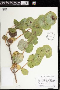 Lonicera prolifera (von Kirchner) Booth ex Rehder 493458[1397617]Smith, Welby 293542002-09-20 United States, Minnesota, Fillmore, Forestville State Park. Fillmore County ... Forestville State Park about 8 miles south-southwest of Fountain ... T 102N R 11W SW1/4 of NW1/4 of Sec 18. 102N 11W 18, 43.6402779 -92.2074966 |
MIN:Plants | Lonicera flava Sims 411205[]Huger, A. s.n. United States, South Carolina, Greenville, Paris Mountain |
MIN:Plants | Lonicera x bella Zabel 904194[]Smith, Welby 280381999-07-21 United States, Minnesota, Lac Qui Parle, Lac Qui Parle County ... About 1 mile southwest of Montevideo ... T117N R41W NE1/4 of NW1/4 of Sec 24;;117N;41W;24, 44.9341667 -95.7469444 |
MIN:Plants | Lonicera involucrata (Richardson) Banks ex C.P.J. Sprengel 510347[]Univ. of Calif. Bot. Gard. list 17 - 81974-00-00 United States, California, San Mateo, San Mateo Co. |
MIN:Plants | 915839[]Whitfeld, T.J.S. 7082006-08-03 United States, Minnesota, Hubbard, Hubbard County...1/2 mile northeast of Cty Hwy 24; between Petit Lake and Mantrap Lake...UTM (NAD83): E354370 N5214053;;141N;34W;01, 47.0638889 -94.9177778 |
MIN:Plants | Lonicera morrowii A. Gray 459588[]Smith, Welby 277441999-05-17 United States, Minnesota, Olmsted, Olmsted County ... Chester Woods County Park, about 5 miles east of Rochester ... T106N R12W SW1/4 of NW1/4 fo Sec 18;Chester Woods County Park;106N;12W;18, 43.9875 -92.3158333 |
MIN:Plants | Lonicera dioica var. glaucescens (Rydberg) Butters 911917[]Smith, Welby 230691993-07-21 United States, Minnesota, McLeod, McLeod County...On the east side of Hook Lake, about 3 miles north of Hutchinson...between the lake and County road 61...T 117N R 29W SW1/4 of SW1/4 of Sec 9. 117N 29W 9, 44.9519444 -94.335 |
MIN:Plants | Lonicera caerulea var. villosa (Michaux) Torrey & A. Gray 897491[]Smith, Welby 292372001-07-26 United States, Minnesota, Cook, Cook County...About 7 miles north of Grand Marais, in the Superior National Forest...T62N R1E NE1/4 of SW1/4 of Sec 8;Superior National Forest;062N;01E;08, 47.8663889 -90.3533333 |
MIN:Plants | Lonicera caerulea var. villosa (Michaux) Torrey & A. Gray 438871[]Zager, S. 1441998-06-18 United States, Minnesota, Crow Wing, Crow Wing County ... T137N R26W NE1/4 of NE1/4 of NE1/4 of Section 23 ... MCBS Site CW 21;;137N;26W;23, 46.6705556 -93.9266667 |
MIN:Plants | 904209[]Smith, Welby 278181999-05-28 United States, Minnesota, Marshall, Marshall County ... Along the Middle River on the west side of Newfolden ... T156N R44W NE1/4 of NW1/4 of Sec 8;;156N;44W;08, 48.3563889 -96.3380556 |
MIN:Plants | Lonicera hirsuta Eaton 491316[]Smith, Welby 279501999-06-29 United States, Minnesota, Carlton, Carlton County ... At the rest stop on N-bound I-35, about 10 miles north of Moose Lake (town) ...T47N R18W NE1/4 of NE1/4 of Sec 22. 047N 18W 22, 46.5455556 -92.6138889 |
MIN:Plants | 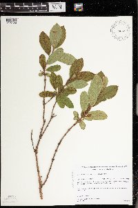 Lonicera caerulea var. villosa (Michaux) Torrey & A. Gray 492663[1397634]Gerdes, Lynden; et al. 37661999-08-07 United States, Minnesota, Cook, Just east of the Cross River and approximately 0.30 miles north of the Gunflint Trail (Cty. 12). NENW of section;Superior National Forest;065N;04W;25, 48.08417 -90.782109 |
MIN:Plants | Lonicera x bella Zabel 427212[]Smith, Welby 222061993-05-25 United States, Minnesota, Meeker, Meeker County ... On the south side of T.H. 12, about 2 miles southeast of Darwin ... T119N R30W NW1/4 of SE1/4 of Sec25;;119N;30W;25, 45.0872231 -94.3916702 |
MIN:Plants |  Lonicera canadensis W. Bartram ex Marshall 461222[1397572]Gerdes, Lynden 26651998-06-11 United States, Minnesota, Cook, T65N R01W S33NESW. Cook County; Superior National Forest. Caribou Rock Hiking trail, east of Moss Lake.;Superior National Forest;065N;01W;33, 48.069998 -90.459508 |
MIN:Plants | Lonicera caerulea var. villosa (Michaux) Torrey & A. Gray 499520[]Whitfeld, T.J.S. 5422004-08-08 United States, Minnesota, Otter Tail, Otter Tail County ... 3 1/2 miles north of New York Mills, 1/2 mile east of County Hwy. 67 ... T136N 37W NESW 21;;136N;37W;21, 46.578863 -95.353441 |
MIN:Plants | 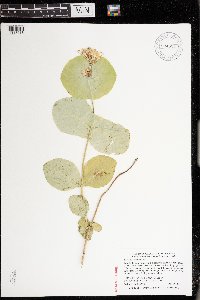 Lonicera prolifera (von Kirchner) Booth ex Rehder 904524[1397618]Smith, Welby 293812003-06-10 United States, Minnesota, Fillmore, Forestville State Park. Fillmore County ... Forestville State Park about 8 miles south-southwest of Fountain (town) ... T102N R11W SW1/4 of NW1/4 of Sec 18. 102N 11W 18, 43.6402778 -92.2075 |
MIN:Plants | Lonicera caerulea var. villosa (Michaux) Torrey & A. Gray 440931[]Smith, Welby 270731998-05-13 United States, Minnesota, Koochiching, Pine Island State Forest. Koochiching County ... On the east bank of the Big Fork River, about 5 miles south of Lindford ... T 156N R 25W SW1/4 of SE1/4 of Sec 11. 156N 25W 11, 48.3408318 -93.8097229 |
MIN:Plants | Lonicera caerulea var. villosa (Michaux) Torrey & A. Gray 490542[]Gerdes, Lynden; et al. 35061999-06-24 United States, Minnesota, Cook, Superior National Forest. T65N R02W S17SWSE Cook County ... Superior National Forest. Thuja/Picea swamp south of small drainage entering the northeastern most bay of Gunflint Lake.. 065N 02W 17, 48.11124 -90.609239 |
Google Map
Google Maps is a web mapping service provided by Google that features a map that users can pan (by dragging the mouse) and zoom (by using the mouse wheel). Collection points are displayed as colored markers that when clicked on, displays the full information for that collection. When multiple species are queried (separated by semi-colons), different colored markers denote each individual species.