University of Minnesota
http://www.umn.edu/
612-625-5000
http://www.umn.edu/
612-625-5000
Minnesota Biodiversity Atlas
Bell Museum
Dataset: MIN-Plants
Taxa: Lonicera
Search Criteria: excluding cultivated/captive occurrences
Bell Museum plants | |
 MIN:Plants | Lonicera dioica var. glaucescens (Rydberg) Butters 194914[]Ainslie, G. s.n.1904-05-28 United States, Minnesota, Olmsted, Rochester;;106N;14W;, 43.97834 -92.49834 |
MIN:Plants | Lonicera dioica var. glaucescens (Rydberg) Butters 194915[]Rosendahl, C. 27031913-05-23 United States, Minnesota, Scott, Minn. R. Valley, near Savage;Minnesota Valley National Wildlife Refuge;;;, 44.779444 -93.346667 |
MIN:Plants | 194916[]Rosendahl, C.; Butters, F. 25571912-05-25 United States, Minnesota, Ramsey, near White Bear;;030N;22W;, 45.079894 -93.045502 |
MIN:Plants | Lonicera dioica var. glaucescens (Rydberg) Butters 194919[]Rosendahl, C. 24531910-04-30 United States, Minnesota, Snelling Reservation [old regional park spanning junction of Minnesota and Mississippi rivers];;028N;23W;, 44.90516 -93.16646 |
MIN:Plants | Lonicera dioica var. glaucescens (Rydberg) Butters 194921[]Rosendahl, C. 47951925-05-03 United States, Minnesota, Winona, near Lamoille, Winona County;Dorer Memorial Hardwood State Forest;106N;05W;, 43.963328 -91.43962 |
MIN:Plants | Lonicera dioica var. glaucescens (Rydberg) Butters 194935[]Butters, F.; et al. R.27881914-06-13 United States, Minnesota, Morrison, Near Randall, Morrison Co.;;130N;30W;07, 46.085832 -94.504664 |
MIN:Plants | Lonicera dioica var. glaucescens (Rydberg) Butters 194936[]Sheldon, Edmund 51-71891-05-00 United States, Minnesota, Hennepin, Lake Calhoun. Hennepin Co.;;028N;24W;, 44.905108 -93.288483 |
MIN:Plants | Lonicera dioica var. glaucescens (Rydberg) Butters 194937[]Herrick, C. s.n.1884-06-00 United States, Minnesota, Saint Louis, St. Louis R. [other collections indicated St. Louis Co.];;;;, 47.589862 -92.461466 |
MIN:Plants | Lonicera dioica var. glaucescens (Rydberg) Butters 194938[]Moyer, Lycurgus 34571909-06-05 United States, Minnesota, Chippewa, near Montevideo;;117N;40W;, 44.934626 -95.675774 |
MIN:Plants | 194940[]Ainslie, G. 34581902-05-24 United States, Minnesota, Olmsted, Rochester;;106N;14W;, 43.97834 -92.49834 |
MIN:Plants | 194943[]Sheldon, Edmund s.n.1891-05-00 United States, Minnesota, Ramsey, Ramsey Co.;;;;, 45.008836 -93.08764 |
MIN:Plants | Lonicera dioica var. glaucescens (Rydberg) Butters 194953[]Butters, F. s.n.1918-05-31 United States, Minnesota, Carlton, Carlton Co.;;;;, 46.59 -92.704719 |
MIN:Plants | Lonicera dioica var. glaucescens (Rydberg) Butters 194957[]Butters, F. s.n.1914-10-03 United States, Minnesota, Dakota, 2 mi east of Mendota;;028N;23W;, 44.887181 -93.123507 |
MIN:Plants | 194958[]Sheldon, Edmund S.33531892-08-00 United States, Minnesota, Otter Tail, Battle Lake;;133N;40W;, 46.32559 -95.717658 |
MIN:Plants | Lonicera dioica var. glaucescens (Rydberg) Butters 194962[]Sheldon, Edmund S5091891-06-00 United States, Minnesota, Waseca, Waseca;;107N;22W;, 44.065777 -93.466531 |
MIN:Plants | Lonicera dioica var. glaucescens (Rydberg) Butters 194965[]Skinner, S. 2911902-00-00 United States, Minnesota, Cottonwood, S shore Bingham L. Cottonwood Co. [pencilled later] Heron Lake Region;;105N;35W;, 43.891124 -95.03971 |
MIN:Plants | Lonicera dioica var. glaucescens (Rydberg) Butters 194967[]Frost, W. F1471892-06-00 United States, Minnesota, Meeker, Acton [pioneer village], Meeker Co.;;119N;32W;26, 45.08778 -94.66538 |
MIN:Plants | 225037[]Holzinger, John s.n.1905-05-00 United States, Minnesota, Winona, Bluff back of Buck bungalow, etc. ... in Winona Co.;;;;, 44.05 -91.6333 |
MIN:Plants | Lonicera dioica var. glaucescens (Rydberg) Butters 253524[]Moore, John 250241960-06-16 United States, Minnesota, Kittson, Kittson County ... 1/2 mi. south of twin churches north east of Lancaster;;162N;478W;, 48.847124 -96.7333 |
MIN:Plants | Lonicera dioica var. glaucescens (Rydberg) Butters 265629[]Stevenson, J. 11912-06-18 United States, Minnesota, Beltrami, Bemidji;;146N;33W;, 47.453829 -94.863614 |
MIN:Plants | Lonicera dioica var. glaucescens (Rydberg) Butters 271204[]Miller, Lillian 641906-05-22 United States, Minnesota, Hennepin, Excelsior;;117N;23W;, 44.934923 -93.584208 |
MIN:Plants | Lonicera dioica var. glaucescens (Rydberg) Butters 276216[]Grant, Martin 30151929-08-03 United States, Minnesota, Clearwater, Itasca Park ... County: Clearwater. Loc.: White Earth Reservation. Sec. 30, T143, R37. [not in the park];White Earth Indian Reservation;143N;37W;30, 47.173009 -95.413863 |
MIN:Plants | 282311[]Rosendahl, C. 61801930-05-25 United States, Minnesota, on Anoka-Isanti Co. line, about 1-1/2 mi. E of Hwy. 5 [hwy 65?];;034N;23W;00, 45.428063 -93.203997 |
MIN:Plants | 282312[]Rosendahl, C. 61751930-05-20 United States, Minnesota, Ramsey, In Rice St. tamarack swamp, Ramsey Co.;;;;, 45.01623 -93.10604 |
MIN:Plants | Lonicera dioica var. glaucescens (Rydberg) Butters 282313[]Rosendahl, C. 61791930-05-25 United States, Minnesota, Anoka-Isanti Co. line. 1-1/2 mi. Hwy. 5 [probably hwy 65];;034N;23W;00, 45.428063 -93.203997 |
MIN:Plants | 288519[]Erickson, Lawrence s.n.1915-05-00 United States, Minnesota, Hennepin, Near r.r. tracks at Ft. Snelling;Fort Snelling Military Reservation;028N;23W;, 44.905162 -93.166462 |
MIN:Plants | Lonicera dioica var. glaucescens (Rydberg) Butters 288590[]Beach, W. 941914-05-25 United States, Minnesota, Ramsey, Como Park, St. Paul;;029N;23W;, 44.992077 -93.166387 |
MIN:Plants | Lonicera dioica var. glaucescens (Rydberg) Butters 291873[]Fryklund, P. s.n.1925-06-07 United States, Minnesota, Roseau, Roseau Co.;;;;, 48.775139 -95.810817 |
MIN:Plants | 301908[]Himebaugh, W. s.n.1928-05-00 United States, Minnesota, Chisago, Taylors Falls;Saint Croix National Riverway;034N;19;, 45.426028 -92.716274 |
MIN:Plants | Lonicera dioica var. glaucescens (Rydberg) Butters 337056[]Lakela, Olga 14231936-06-19 United States, Minnesota, Saint Louis, lLake side at 30th St, Duluth;;;;, 46.74598 -92.06749 |
MIN:Plants | Lonicera dioica var. glaucescens (Rydberg) Butters 337057[]Lakela, Olga 14241936-06-19 United States, Minnesota, Saint Louis, lLake side at 30th St, Duluth;;;;, 46.74598 -92.06749 |
MIN:Plants | 351226[]Seashore, Mauritz s.n.1932-05-20 United States, Minnesota, Scott, Savage;;115N;21W;, 44.753605 -93.344349 |
MIN:Plants | Lonicera dioica var. glaucescens (Rydberg) Butters 352522[]Nielsen, E. 24911934-06-01 United States, Minnesota, Becker, South boundary, Itasca State Park;Itasca State Park;142N;36W;, 47.108802 -95.233537 |
MIN:Plants | Lonicera dioica var. glaucescens (Rydberg) Butters 357972[]Rosendahl, C. 3251902-06-04 United States, Minnesota, Houston, Spring Grove;;101N;07W;, 43.543923 -91.6707 |
MIN:Plants | Lonicera dioica var. glaucescens (Rydberg) Butters 361445[]Lakela, Olga 36821940-07-05 United States, Minnesota, Cook, near Windigo Point, Sea Gull Lake. Cook Co.;Boundary Waters Canoe Area Wilderness / Superior National Forest;065N;05W;, 48.149256 -90.887916 |
MIN:Plants | 366463[]Rosendahl, C. 71281939-07-11 United States, Minnesota, Houston, Riceford Creek Valley, Houston County;Dorer Memorial Hardwood State Forest;;;, 43.605113 -91.707515 |
MIN:Plants | Lonicera dioica var. glaucescens (Rydberg) Butters 367230[]Moore, John; Butters, F. 134801940-09-03 United States, Minnesota, Pine, South shore of Sturgeon Lake. Pine County;;045N;19W;, 46.374946 -92.7409 |
MIN:Plants | Lonicera dioica var. glaucescens (Rydberg) Butters 368320[]Moore, John; et al. 128711940-05-28 United States, Minnesota, Big Stone, near Big Stone Lake; 1 mile north of Ortonville, Big Stone County;;121NN;46W;, 45.284263 -96.412452 |
MIN:Plants | Lonicera dioica var. glaucescens (Rydberg) Butters 368756[]Lakela, Olga 43671941-06-14 United States, Minnesota, Saint Louis, about 13.5 mi. N. of Duluth on Highway No. 4. St. Louis Co.;;;;, 46.925315 -92.153623 |
MIN:Plants | Lonicera dioica var. glaucescens (Rydberg) Butters 369425[]Moore, John; et al. 146911941-07-06 United States, Minnesota, Douglas, 1 mile south of Garfield, Douglas County;;128N;38W;, 45.889822 -95.448171 |
MIN:Plants | Lonicera dioica var. glaucescens (Rydberg) Butters 370239[]Moore, John; et al. 140121941-05-24 United States, Minnesota, Pine, Bank of Snake River, near dam at the outlet of Cross Lake, S.E.1/4 Sec. 26, Pine City Township, Pine County;;039N;21W;26, 45.839139 -92.929089 |
MIN:Plants | Lonicera dioica var. glaucescens (Rydberg) Butters 370319[]Moore, John; et al. 144801941-06-15 United States, Minnesota, Marshall, bank of Thief River, S.W.1/4 Sec. 7, Agder Township, Marshall County;;155N;42W;07, 48.257921 -96.098932 |
MIN:Plants | Lonicera dioica var. glaucescens (Rydberg) Butters 371072[]Moore, John; et al. 138861941-05-10 United States, Minnesota, Mower, north bank of Deer Creek; along Highway 63, Frankford Twp, Mower County;;103N;14W;, 43.717809 -92.50951 |
MIN:Plants | 374015[]Linnaean Club, U of M, 761939-05-21 United States, Minnesota, Rice, Nerstrand Woods. Rice Co. ... Along road near falls.;Nerstrand Woods State Park;110n;19W;, 44.327064 -93.100886 |
MIN:Plants | 375353[]Lakela, Olga 49421942-06-07 United States, Minnesota, Carlton, near Holyoke. Carlton Co.;;046N;16W;, 46.460785 -92.362893 |
MIN:Plants | Lonicera dioica var. glaucescens (Rydberg) Butters 391781[]Lakela, Olga 60251945-07-08 United States, Minnesota, Saint Louis, Sec. 19, Minnesota Point, Duluth;Minnesota Point;049N;13W;19, 46.746391 -92.068224 |
MIN:Plants | 393302[]Lakela, Olga 68701947-06-28 United States, Minnesota, Saint Louis, border on #48, about 10 mi. N.W. of Duluth;;;;, 46.783273 -92.106579 |
MIN:Plants | Lonicera dioica var. glaucescens (Rydberg) Butters 393929[]Butters, F.; Abbe, E. 8681944-08-02 United States, Minnesota, Cook, Cook County ... Lima Mt. T64N, R1W.;Superior National Forest;064N;10W;, 48.019271 -90.447457 |
MIN:Plants | Lonicera dioica var. glaucescens (Rydberg) Butters 405062[]Rosendahl, C. s.n.1945-05-30 United States, Minnesota, Rice, Ravine above waterfall, Nerstrand Woods. Rice County;Nerstrand Woods State Park;110N;19W;, 44.327064 -93.100886 |
MIN:Plants | Lonicera dioica var. glaucescens (Rydberg) Butters 406705[]Lakela, Olga 60251945-07-08 United States, Minnesota, Saint Louis, Sec. 19, Minnesota Point, Duluth;Minnesota Point;049N;13W;19, 46.746391 -92.068224 |
MIN:Plants | Lonicera dioica var. glaucescens (Rydberg) Butters 407398[]Lakela, Olga 83011949-06-18 United States, Minnesota, Saint Louis, on Embarrass River, southeast of Gilbert. St. Louis Co.;;057N;16W;, 47.415411 -92.367857 |
MIN:Plants | Lonicera dioica var. glaucescens (Rydberg) Butters 409186[]Moore, John; Moore, Marjorie 112741939-07-29 United States, Minnesota, Lake of the Woods, Lake of the Woods County ... near the north shore of Magnuson Island;Northwest Angle;168N;34W;, 49.344621 -95.028893 |
MIN:Plants | Lonicera dioica var. glaucescens (Rydberg) Butters 412311[]Moore, John; Moore, Marjorie 117041939-08-14 United States, Minnesota, Koochiching, Koochiching County ... Along the north east shore of Krause Bay, south east of the Island View Hotel, Rainy Lake;Voyageurs National Park;071N;22W;, 48.609164 -93.157413 |
MIN:Plants | Lonicera dioica var. glaucescens (Rydberg) Butters 412355[]Moore, John; Moore, Marjorie 115941939-08-09 United States, Minnesota, Kittson, Kittson County ... along the west line of Section 3, Richardville Township;;163N;48W;03, 48.97022 -96.853365 |
MIN:Plants | Lonicera dioica var. glaucescens (Rydberg) Butters 412905[]Moore, John; Moore, Marjorie 113961939-08-02 United States, Minnesota, Roseau, Roseau County ... west side of road, 1.3 mi. north of Longworth;;164N;37W;, 48.986092 -95.420148, 327m |
MIN:Plants | Lonicera dioica var. glaucescens (Rydberg) Butters 420125[]Lakela, Olga 105301950-06-24 United States, Minnesota, Saint Louis, Embarras [sic] River, south of Biwabik;;058N;16W;, 47.502156 -92.369137 |
MIN:Plants | Lonicera dioica var. glaucescens (Rydberg) Butters 420849[]Lakela, Olga 121201950-09-08 United States, Minnesota, Saint Louis, ridge between Sturgeon and Side Lakes, 20 mi. n. of Hibbing, St. Louis Co.;Sturgeon River State Forest;060N;21W;, 47.675918 -92.996803 |
MIN:Plants | Lonicera dioica var. glaucescens (Rydberg) Butters 420980[]Lakela, Olga 114651950-08-20 United States, Minnesota, Saint Louis, Curtain Falls, Crooked Lake, St. Louis Co.;Boundary Waters Canoe Area Wilderness / Superior National Forest;066N;12W;, 48.186787 -91.869968 |
MIN:Plants | Lonicera dioica var. glaucescens (Rydberg) Butters 442994[]Lakela, Olga 124751951-06-19 United States, Minnesota, Saint Louis, Along the portage trail from Crooked Lake to Iron Lake above Curtain Falls, St. Louis County;Boundary Waters Canoe Area Wilderness / Superior National Forest;066N;12W;06, 48.230794 -91.917027 |
MIN:Plants | Lonicera dioica var. glaucescens (Rydberg) Butters 444926[]Moore, John; Huff, N. 186081946-06-13 United States, Minnesota, Lake of the Woods, Lake of the Woods County ... at Rocky Point, Lake of the Woods;;163N;34W;, 48.930506 -95.025758 |
MIN:Plants | Lonicera dioica var. glaucescens (Rydberg) Butters 445076[]Moore, John; Huff, N. 194471947-06-05 United States, Minnesota, Red Lake, Red Lake County ... along the river, Old Crossing Treaty State Historic Wayside Park;;151N;45W;, 47.891016 -96.417549 |
MIN:Plants | Lonicera dioica var. glaucescens (Rydberg) Butters 446803[]Moore, John; Huff, N. 196101947-06-18 United States, Minnesota, Kandiyohi, Kandiyohi County ... north shore of Lake Andrew, Sibley State Park;Sibley State Park;121N;35W;, 45.282269 -95.070706 |
MIN:Plants | Lonicera dioica var. glaucescens (Rydberg) Butters 463482[]Lakela, Olga 141031952-06-16 United States, Minnesota, Saint Louis, Namakan Narrows. St. Louis Co.;Voyageurs National Park;069N;17W;, 48.428244 -92.527018 |
MIN:Plants | 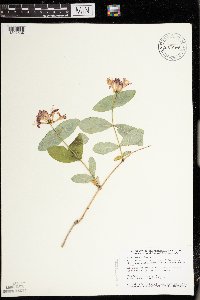 Lonicera dioica var. glaucescens (Rydberg) Butters 475566[1397584]Smith, Welby 151731989-05-30 United States, Minnesota, Kanabec, Mille Lacs Wildlife Management Area. Kanabek [sic] County ... Mille Lacs state Wildlife Management Area, about 9 miles northwest of Mora ... SW1/4 SW1/4 section 16, T 40N R 25W. 040N 25W 16, 45.9511108 -93.4711075 |
MIN:Plants | Lonicera dioica var. glaucescens (Rydberg) Butters 488581[]Moore, John 200701949-06-02 United States, Minnesota, Clay, Clay County ... 6 miles west of Hawley;;139N;46W;, 46.847731 -96.483798 |
MIN:Plants | Lonicera dioica var. glaucescens (Rydberg) Butters 488664[]Moore, John 199931949-05-26 United States, Minnesota, Isanti, Isanti County ... 3 miles north of Cambridge;;036N;23W;, 45.601277 -93.203765 |
MIN:Plants | Lonicera dioica var. glaucescens (Rydberg) Butters 497554[]Moore, John 202021949-06-21 United States, Minnesota, Lake of the Woods, Lake of the Woods County ... 2 miles south west of Wheeler's Point;;162N;32W;, 48.844345 -94.762874 |
MIN:Plants | Lonicera dioica var. glaucescens (Rydberg) Butters 501136[]Moore, John 203581949-06-28 United States, Minnesota, Kittson, Kittson County ... 3 miles west of Hallock;;161N;49W;, 48.760418 -96.996127 |
MIN:Plants | Lonicera dioica var. glaucescens (Rydberg) Butters 525654[]Lakela, Olga 18694a1955-06-04 United States, Minnesota, Saint Louis, St. Louis County ... at the Jct. of Highway 53 and the Lake Kabetogama road.;Kabetogama State Forest;068N;21W;, 48.371676 -93.029337 |
MIN:Plants | Lonicera dioica var. glaucescens (Rydberg) Butters 525899[]Lakela, Olga 186671955-06-04 United States, Minnesota, Saint Louis, St. Louis County ... Sturgeon River, Highway #73;;;;, 47.73274 -92.86627 |
MIN:Plants | Lonicera dioica var. glaucescens (Rydberg) Butters 526191[]Moore, John 210841951-06-26 United States, Minnesota, Todd, Todd County ... 1/2 mi. north east of Philbrook;;133N;32W;, 46.32549 -94.715795 |
MIN:Plants | Lonicera dioica var. glaucescens (Rydberg) Butters 527121[]Lakela, Olga 174941954-06-17 United States, Minnesota, Saint Louis, St. Louis County ... Bank of Little Fork River, on Hwy. 73, N of Chisholm;;062NN;20W;, 47.850414 -92.890745 |
MIN:Plants | Lonicera dioica var. glaucescens (Rydberg) Butters 532988[]Lakela, Olga 202931956-07-06 United States, Minnesota, Lake, above Lake Superior near Two Harbors ore docks, Lake Co.;North Shore;052N;11W;00, 46.997287 -91.751716 |
MIN:Plants | Lonicera dioica var. glaucescens (Rydberg) Butters 543035[]Lakela, Olga; Davidson, Donald 216941957-07-26 United States, Minnesota, Lake, Lake County ... Tomahawk Trail west of Isabella Lake;Superior National Forest;061N;08W;02, 47.794164 -91.309151 |
MIN:Plants | Lonicera dioica var. glaucescens (Rydberg) Butters 554221[]Moore, John 232451957-06-17 United States, Minnesota, Martin, Martin County ... Growing on the west bluff of Cedar Lake, 3/4 of a mile west of Monterey [now part of Trimont];;104N;32W;, 43.804949 -94.674284 |
MIN:Plants | Lonicera dioica var. glaucescens (Rydberg) Butters 554249[]Moore, John 229141956-06-13 United States, Minnesota, Clay, Clay County ... 5 miles south of Rollag;;137N;44W;, 46.674239 -96.236522 |
MIN:Plants | Lonicera dioica var. glaucescens (Rydberg) Butters 568908[]Moore, John 253521961-05-22 United States, Minnesota, Isanti, Isanti County ... NW1/4 Sec. 21, Bethel Twp. [should be Athens Twp.];Cedar Creek National History Area;034N;23W;21, 45.421163 -93.214653 |
MIN:Plants | Lonicera dioica var. glaucescens (Rydberg) Butters 585335[]Moore, John 262621963-05-22 United States, Minnesota, Blue Earth, Blue Earth County ... Growing along the south shore of Lake Crystal, 1/2 mi. east of the town of Crystal Lake;;107N;28W;, 44.065133 -94.188647 |
MIN:Plants | Lonicera dioica var. glaucescens (Rydberg) Butters 592286[]Westkaemper, Remberta s.n.1964-07-00 United States, Minnesota, Stearns, Stearns County ... St. Joseph. Saint Benedict's [College] woods.;;124N;29W;, 45.543642 -94.322053 |
MIN:Plants | Lonicera dioica var. glaucescens (Rydberg) Butters 603653[]Moore, John; Moore, Marjorie 272251967-08-11 United States, Minnesota, Anoka, Anoka County ... south west corner of Cedar Creek Natural History Area;Cedar Creek National History Area;034N;23W;, 45.428063 -93.203997 |
MIN:Plants | Lonicera dioica var. glaucescens (Rydberg) Butters 603699[]Moore, John; Moore, Marjorie 268421966-05-30 United States, Minnesota, Blue Earth, Blue Earth County ... 3 miles north of Goodthunder;;107N;27W;, 44.065178 -94.068431 |
MIN:Plants | Lonicera dioica var. glaucescens (Rydberg) Butters 607289[]Grafstrom, M. 671968-06-19 United States, Minnesota, Pine, Saint Croix State Park. Pine Co. T 41 N, R 18 W, NW1/4 sect. 29. Pine Co. T41N, R18W, NW1/4 Sec. 29.. 041N 18W 29, 46.004541 -92.647086 |
MIN:Plants | Lonicera dioica var. glaucescens (Rydberg) Butters 616543[]Moore, John; Moore, Marjorie 881969-06-03 United States, Minnesota, Crow Wing, Crow Wing Natural History Area. Crow Wing County ... east end of Chandler Lake, S.W.1/4 Sect. 22, Garrison Twp.;Crow Wing Natural Area;044N;28W;22, 46.27899 -93.863336 |
MIN:Plants | Lonicera dioica var. glaucescens (Rydberg) Butters 623116[]Moore, John 273681971-05-28 United States, Minnesota, Anoka, Anoka County ... west of D.B. Lawrence's Cabin, Bethel Twp, Cedar Creek Natural History Area.;Cedar Creek National History Area;034N;23W;, 45.428063 -93.203997 |
MIN:Plants | Lonicera dioica var. glaucescens (Rydberg) Butters 655193[]Gage Jr., Addison 411876-05-30 United States, Minnesota, Hennepin, Minneapolis;;;;, 44.98 -93.26361 |
MIN:Plants | Lonicera dioica var. glaucescens (Rydberg) Butters 687072[]Wheeler, Gerald; Glaser, Paul 14981977-05-29 United States, Minnesota, Itasca, Itasca County ... NW1/4NW1/4 Sec. 21 T55N R26W; approx. 5 miles west of Grand Rapids.;;055N;26W;21, 47.232383 -93.64948 |
MIN:Plants | Lonicera dioica var. glaucescens (Rydberg) Butters 689837[]Ownbey, Gerald 56141977-07-19 United States, Minnesota, Wadena, Wadena County ... T134N R35W, Sec. 20, SE1/4. E side of U.S. Rte. 71, 3.2 mi. S of its jct with U.S. Rte. 10 in Wadena.;;134N;35W;20, 46.405284 -95.124794 |
MIN:Plants | Lonicera dioica var. glaucescens (Rydberg) Butters 691040[]Sperling, C. 1391976-05-25 United States, Minnesota, Douglas, Douglas County ... 1 mi. south, 1/2 mi. west of Holmes City.;;127N;39W;, 45.802991 -95.572061 |
MIN:Plants | Lonicera dioica var. glaucescens (Rydberg) Butters 697950[]Ownbey, Gerald 51371976-05-23 United States, Minnesota, Washington, Washington County ... Afton State Park. T 28 N, R 20 W, SW 1/4 Sect. 34.;Afton State Park;028N;20W;34, 44.869168 -92.791591 |
MIN:Plants | Lonicera dioica var. glaucescens (Rydberg) Butters 697969[]Ownbey, Gerald 51381976-05-23 United States, Minnesota, Washington, Washington County ... Afton State Park. T 28 N, R 20 W, SW 1/4 Sect. 34.;Afton State Park;028N;20W;34, 44.869168 -92.791591 |
MIN:Plants | Lonicera dioica var. glaucescens (Rydberg) Butters 698809[]Sather, Nancy; et al. 5181977-06-14 United States, Minnesota, Lake, Lake County ... south of HWY 173. SW1/4, NE1/4, S35, T61N, R10W.;Superior National Forest;061N;10W;35, 47.726429 -91.565605 |
MIN:Plants | Lonicera dioica var. glaucescens (Rydberg) Butters 700871[]Dorio, J. 5061977-07-12 United States, Minnesota, Morrison, Morrison County ... Lake Alexander about 7 mi. N of Randall on county road 6 ... T 131 N, R 30 W, Sec. 6.;Lake Alexander Preserve, The Nature Conservancy;131N;30W;06, 46.187068 -94.506235 |
MIN:Plants | Lonicera dioica var. glaucescens (Rydberg) Butters 709733[]Wheeler, Gerald 47421979-08-03 United States, Minnesota, Big Stone, Big Stone County ... Approx. 2.5 mi. northwest of Ortonville on Route 7. T122N, R46W, Sec. 32.;;122N;46W;32, 45.33319 -96.461499 |
MIN:Plants | Lonicera dioica var. glaucescens (Rydberg) Butters 717563[]Grimmelbein, G. 1531979-06-24 United States, Minnesota, Hubbard, Hubbard County ... Spearhead Lake Preserve;Spearhead Lake Preserve (Audubon);145N;34W;, 47.368099 -94.990966 |
MIN:Plants | 720292[]Ottoson, S. 421979-06-20 United States, Minnesota, 2 miles southwest of Fertile.;Agassiz Dunes Scientific Natural Area;;;, 47.51564 -96.31032 |
MIN:Plants | Lonicera dioica var. glaucescens (Rydberg) Butters 726355[]Smith, Welby 21671980-05-25 United States, Minnesota, Wright, Wright County ... T 122N R 27W; NW1/4 SE1/4 Sec. 16. On the east bank of the Clearwater River, about 4 miles south of its confluence with the Mississippi River in Clearwater.. 122N 27W 16, 45.376077 -94.080341 |
MIN:Plants | Lonicera dioica var. glaucescens (Rydberg) Butters 727705[]Lustig, K. 4401979-06-08 United States, Minnesota, Sherburne, Mississippi River Islands Scientific Natural Area. Sherburne & Wright Cos. ...Mississippi Scenic and Recreational River Islands SNA: Mississippi River Islands between Monticello and Elk River, Sec. 2, 3, 4, T 32N, R 26, 27W; Sec. 7, 9, 18, T 121N, R 23, 24W.. 032N 26W 3, 45.293483 -93.556246 |
MIN:Plants | Lonicera dioica var. glaucescens (Rydberg) Butters 728103[]Eikum, B. 561979-06-03 United States, Minnesota, Dakota, Dakota County ... Hastings Scientific and Natural Area: Hastings, sec. 23, 34, 35, T115N, R17W.;Hastings Scientific Natural Area;115N;17W;00, 44.739075 -92.862655 |
MIN:Plants | Lonicera dioica var. glaucescens (Rydberg) Butters 728547[]Sperling, C. 47661979-06-16 United States, Minnesota, Polk, Polk County ... Agassiz Dunes; about 1.5 miles southwest of Fertile.;Agassiz Dunes Scientific Natural Area;147N;44W;, 47.543099 -96.259086 |
MIN:Plants | 729561[]Cutler, S. 1391980-07-16 United States, Minnesota, Pine, Pine County ... St. Croix Natural Area: 21 mi. east of Hinckley. NW1/4 SE1/4 Sec. 33, T41, R17W.;Saint Croix State Park;041N;17W;33, 45.990519 -92.498401 |
Google Map
Google Maps is a web mapping service provided by Google that features a map that users can pan (by dragging the mouse) and zoom (by using the mouse wheel). Collection points are displayed as colored markers that when clicked on, displays the full information for that collection. When multiple species are queried (separated by semi-colons), different colored markers denote each individual species.