University of Minnesota
http://www.umn.edu/
612-625-5000
http://www.umn.edu/
612-625-5000
Minnesota Biodiversity Atlas
Bell Museum
Dataset: MIN-Plants
Taxa: Dryopteris
Search Criteria: excluding cultivated/captive occurrences
Bell Museum plants | |
 MIN:Plants | 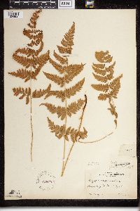 Dryopteris carthusiana (Villars) H.P. Fuchs 220442[1324509]Cooper, William 1001909-07-14 United States, Michigan, Keweenaw, Raspberry Id. Isle Royale;Isle Royale National Park;;;, 48.010955 -88.828422 |
MIN:Plants | 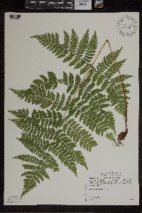 Dryopteris expansa (C. Presl) Fraser-Jenkins & Jermy 432675[1305881]Gerdes, Lynden 40402000-07-12 United States, Minnesota, Lake, North Shore. T57N R06W S19NWSW. Lake County...Little Marais...approximately 1/2 mile ESE of the Superior Hiking Trail and County 6 junction. Approx. 0.85 mile ESE of the Finland Cemetary.. 057N 06W 19, 47.583104 -91.421915 |
MIN:Plants | 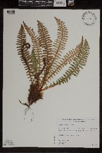 Dryopteris fragrans (L.) Schott 461210[1305896]Gerdes, Lynden 27041998-06-15 United States, Minnesota, Cook, T65N R01W S30NWSE. Cook County; Superior National Forest, BWCAW. North-facing cliff feature east of Dunn Lake.;Boundary Waters Canoe Area Wilderness / Superior National Forest;065N;01W;30, 48.085302 -90.502066 |
MIN:Plants | 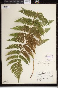 298438[1324688]Tryon, R. 23521935-08-28 United States, Indiana, Porter, Dunes State Park, Porter Co.;Indiana Dunes National Lakeshore;;;, 39.960966 -86.330078 |
MIN:Plants |  Dryopteris expansa (C. Presl) Fraser-Jenkins & Jermy 656941[1324765]Noble, Mark 3611974-08-05 United States, Alaska, Muir Point; from site deglaciated ca. 1880.;Glacier Bay National Park;;;, 58.827414 -136.07866 |
MIN:Plants | Dryopteris intermedia (Muhlenberg ex Willdenow) A. Gray 549466[]Umbach, L. 51481909-10-09 United States, Indiana, Porter, Dune Park;Indiana Dunes National Lakeshore;;;, 39.960966 -86.330078 |
MIN:Plants |  Dryopteris expansa (C. Presl) Fraser-Jenkins & Jermy 899487[1305882]Smith, Welby 292042001-06-26 United States, Minnesota, Cook, Cook County...Along the Superior Hiking Trail about 2 miles northwest of Tofte...T 59N R 4W NE1/4 of NW1/4 of Sec 17;North Shore / Superior National Forest;059N;04W;17, 47.5994444 -90.8619444 |
MIN:Plants |  Dryopteris filix-mas (L.) Schott 354076[1324824]Eggler, W. 2271937-09-15 United States, Idaho, Butte, Craters of the Moon National Monument. Butte County;Craters of the Moon National Monument;;;, 44.700534 -115.290039, 1707m |
MIN:Plants |  Dryopteris cristata (L.) A. Gray 915984[1324017]Smith, Welby 224901993-06-18 United States, Minnesota, Grant, Grant County...On the south side of Ask Lake, about 1.5 miles east-southest of Ashby...T 130N R 41W NW1/4 of SW1/4 of Sec 12. 130N 41W 12, 46.0847222 -95.7886111 |
MIN:Plants |  Dryopteris fragrans (L.) Schott 52208[1324883]Wheeler, William 6781900-08-00 United States, Michigan, Keweenaw, Tobin Harbor, Isle Royale;Isle Royale National Park;;;, 48.010955 -88.828422 |
MIN:Plants |  Dryopteris intermedia (Muhlenberg ex Willdenow) A. Gray 432677[1324384]Gerdes, Lynden 42342000-08-17 United States, Minnesota, Lake, T57N R07W S24SENW. Lake County...Finland, MN. Approximately 0.25 mile south of the Finland Cemetary.;North Shore;057N;07W;24, 47.583104 -91.421915 |
MIN:Plants |  Dryopteris carthusiana (Villars) H.P. Fuchs 904450[1327642]Smith, Welby 282371999-08-31 United States, Minnesota, Itasca, Itasca County...About 10 miles south of Nashwauk...T 55N R 22W NW1/4 of NW1/4 of Sec 29;;055N;22W;29, 47.2241667 -93.1658333 |
MIN:Plants |  Dryopteris fragrans (L.) Schott 491416[1305893]Gerdes, Lynden 41452000-07-25 United States, Minnesota, Lake, T57N R07W S35NWSW. Lake County ... Wolf Ridge Environmental Learning Center, Finland ... south side of Wolf Lake.;North Shore / Wolf Ridge Environmental Center;057N;07W;35, 47.583104 -91.421915 |
MIN:Plants |  Dryopteris cristata (L.) A. Gray 906511[1324112]Smith, Welby 309622008-07-02 United States, Minnesota, Saint Louis, St. Louis County...About 18 miles E-SE of Gilbert, in Superior National Forest...T57N R14W SW1/4 of SW1/4 of Sec 34;Superior National Forest;057N;14W;34, 47.3744444 -92.1072222 |
MIN:Plants |  Dryopteris carthusiana (Villars) H.P. Fuchs 511112[1327531]Wheeler, Gerald 168741997-07-26 United States, Minnesota, Stearns, Stearns County ... Ca. 5 mi. N of St. Joseph, W of Rte. 4 ... NW1/4 SW1/4 SE1/4 Sec. 16 T125N R29W (St. Wendel 16);;125n;29W;16, 45.55 -94.3167 |
MIN:Plants |  Dryopteris fragrans (L.) Schott 297710[1324854]Mexia, Ynes 21561928-07-28 United States, Alaska, McKinley National Park ... Near center of N. Boundary of Park... above Wonder Lake.;Denali National Park;;;, 63.45884 -150.86412, 700m |
MIN:Plants | Dryopteris marginalis (L.) A. Gray 515456[1305916]Lee, Michael United States, Minnesota, Fillmore, Detailed locality information protected. This is typically done to protect rare or threatened species localities. |
MIN:Plants |  Dryopteris expansa (C. Presl) Fraser-Jenkins & Jermy 490521[1305883]Lee, Michael MDL27522000-06-22 United States, Minnesota, Lake, Superior National Forest. Lake County...east of Ninemile Creek and County Road 7 in the Superior National Forest 2-1/2 miles north-northeast of Cramer...ridge north of Paccini Lake...T59N R6W SW1/4 of SE1/4 Sec. 27. 059N 06W 27, 47.583104 -91.421915 |
MIN:Plants |  Dryopteris carthusiana (Villars) H.P. Fuchs 907010[1327640]Smith, Welby 311302008-08-18 United States, Minnesota, Beltrami, Beltrami County...About 12 miles north-northeast of Bemidji...T 148 R 33 SW1/4 of NE1/4 of Sec 12;Buena Vista State Forest;148N;33W;12, 47.6522222 -94.8072222 |
MIN:Plants |  Dryopteris intermedia (Muhlenberg ex Willdenow) A. Gray 917053[1324365]Gerdes, Lynden 57772009-07-13 United States, Minnesota, Cook, Superior National Forest. T64N R03E S15NENENENW. Cook County, MN. Superior National Forest. Approximately 0.92 miles SE of McFarland Lake and 0.11 mile northeast off Cty. Rd. 16...NAD 83 / 720269 / 5324384. 064N 03E 15, 48.0347222 -90.045 |
MIN:Plants |  Dryopteris fragrans (L.) Schott 914627[1324291]Smith, Welby 314282009-08-29 United States, Minnesota, Cook, Boundary Waters Canoe Area Wilderness / Superior National Forest. Cook County ... Boundary Waters Canoe Area Wilderness, Superior National Forest. Just north of Winchell Lake ... T64N R2W NW1/4 of SW1/4 of Sec 29. 064N 02W 29, 47.9958333 -90.6158333 |
MIN:Plants |  Dryopteris carthusiana (Villars) H.P. Fuchs 510757[1327530]Wheeler, Gerald 159971997-06-08 United States, Minnesota, Nicollet, Swan Lake Wildlife Management Area. Nicollet County ... Ca. 4 mi. SSW of Nicollet on Rte. 23; Swan Lake State WMA, North Star Unit ... NW1/4 NW1/4 NE1/4 Sec. 28 T109N R28W (Nicollet 28). 109N 28W 28, 44.217999 -94.200153 |
MIN:Plants |  Dryopteris expansa (C. Presl) Fraser-Jenkins & Jermy 584657[1324759]Morean, Edith 2001962-08-07 United States, Washington, Washington: Olympic National Park; Collins Camp just outside of east boundary.;Olympic National Park;;;, 47.803236 -123.666112 |
MIN:Plants |  Dryopteris expansa (C. Presl) Fraser-Jenkins & Jermy 656920[1324762]Noble, Mark 3711974-08-05 United States, Alaska, Muir Point; from site deglaciated ca. 1880.;Glacier Bay National Park;;;, 58.827414 -136.07866 |
MIN:Plants |  Dryopteris cristata (L.) A. Gray 917055[1324015]Gerdes, Lynden 58142009-07-24 United States, Minnesota, Cook, Boundary Waters Canoe Area Wilderness / Superior National Forest. T64N R05W S03NWSENWNE. Cook County, MN. Superior National Forest. Boundary Waters Canoe Area Wilderness. Northern shores bog pond between Gillis Lake and French Lake...NAD 83 / 653004/ 5325064. 064N 05W 3, 48.0605556 -90.9463889 |
MIN:Plants |  Dryopteris cristata (L.) A. Gray 917063[1324013]Gerdes, Lynden 58992009-08-25 United States, Minnesota, Cook, Boundary Waters Canoe Area Wilderness / Superior National Forest. T66N R05W S12 NWSESWNW Cook County ... Superior National Forest. Boundary Waters Canoe Area Wilderness. Saganaga Lake. Munker Island.. T066N R05W S12, 48.215119 -90.912522 |
MIN:Plants | 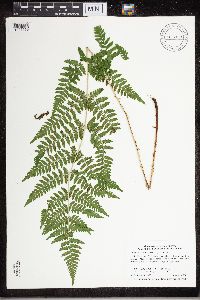 Dryopteris carthusiana (Villars) H.P. Fuchs 915939[1327559]Smith, Welby 313732009-08-13 United States, Minnesota, Blue Earth, Cobb Wildlife Management Area. Blue Earth County ... Cobb Waterfowl Production Area, about 13 miles south of Mankato ... T106N R26W NW1/4 of NW1/4 of Sec 23. 106N 26W 23, 43.9758333 -93.9244444 |
MIN:Plants | 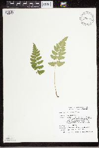 Dryopteris cristata (L.) A. Gray 489529[1324131]Smith, Michael 1481996-08-17 United States, Minnesota, Saint Louis, Voyageurs National Park. St. Louis Co.; Plot name: Voya 16 DNR # 5774; Hitchcock Bay/ 48 32'49" 92 54'46";Voyageurs National Park;070N;20W;, 48.5469437 -92.9127808 |
MIN:Plants | 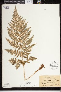 Dryopteris expansa (C. Presl) Fraser-Jenkins & Jermy 600085[1324761]Cooper, William s.n.1929-07-20 United States, Alaska, Glacier Bay 18.;Glacier Bay National Park;;;, 58.797845 -136.458473 |
MIN:Plants | 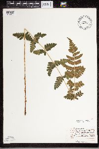 Dryopteris cristata (L.) A. Gray 474405[1324133]Moore, John 4501971-08-11 United States, Minnesota, Sherburne, NW/4 S - 13 Orrock Tshp.;Sherburne National Wildlife Refuge;034N;27W;13, 45.4333 -93.7333 |
MIN:Plants |  Dryopteris cristata (L.) A. Gray 904446[1324025]Smith, Welby 282451999-08-31 United States, Minnesota, Itasca, Itasca County...About 14 miles north of Nashwauk...T 55N R 22W SE1/4 of NW1/4 of Sec 20;George Washington State Forest;055N;22W;29, 47.585 -93.1527778 |
MIN:Plants |  Dryopteris cristata (L.) A. Gray 915045[1324016]Smith, Welby 313752009-08-13 United States, Minnesota, Blue Earth, Cobb Wildlife Management Area. Blue Earth County ... Cobb Waterfowl Production Area, about 13 miles south of Mankato ... T106N R26W NW1/4 of NW1/4 of Sec 23. 106N 26W 23, 43.9758333 -93.9244444 |
MIN:Plants |  Dryopteris cristata (L.) A. Gray 438864[1324114]Wolff, Jan W11993-08-27 United States, Minnesota, Kanabec, Kanabec County ... Pomroy Lake ... T41N R22W NW1/4 of NW1/4 of Sec 19;;041N;22W;19, 46.0230556 -93.1769444 |
MIN:Plants |  Dryopteris intermedia (Muhlenberg ex Willdenow) A. Gray 432496[1324383]Gerdes, Lynden 41282000-07-25 United States, Minnesota, Lake, North Shore / Wolf Ridge Environmental Center. T57N R07W S34NESE. Lake County...Wolf Ridge Enfironmental Learning Center, Finland, MN. Drainage; southwest of the northwest corner of Wolf Lake.. 057N 07W 34, 47.583104 -91.421915 |
MIN:Plants |  Dryopteris cristata (L.) A. Gray 914529[1324019]Smith, Welby 250991994-08-16 United States, Minnesota, Itasca, Scenic State Park. Itasca County...In Scenic State Park; about 9 miles south-southeast of Effie...T 60N R 25W SW1/4 of SW 1/4 of Sec 6. 60N 25W 6, 47.7027778 -93.5733333 |
MIN:Plants |  Dryopteris fragrans (L.) Schott 474175[1305891]Bockenstedt, P. 000022000-07-24 United States, Minnesota, Lake, North Shore. E 1/2, NW 1/4, Sec. 2, T55N, R8W, Lake County; basalt cliff above Beaver River. Just below crossing of pipeline road (Northshore Mining Co.) over Beaver River.. 055N 08W 2, 47.583104 -91.421915 |
MIN:Plants |  Dryopteris expansa (C. Presl) Fraser-Jenkins & Jermy 474382[1305886]Scott, P. 11051998-08-13 United States, Minnesota, Cook, Cook Co. Cedar swamp on the S side of Hungry Jack Lake. T64N R1W sec. 3 SENESE.;Superior National Forest;064N;01W;3, 48.054938 -90.437086 |
MIN:Plants |  Dryopteris expansa (C. Presl) Fraser-Jenkins & Jermy 488951[1305879]Lee, Michael MDL27222000-06-12 United States, Minnesota, Lake, North Shore. Lake County...Superior Hiking Trail 4-1/2 miles east of Finland...along small tributary of Sawmill Creek...T57N R7W NE1/4 of SE1/4 Sec. 13. 057N 07W 13, 47.583104 -91.421915 |
MIN:Plants | 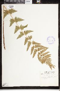 Dryopteris cristata (L.) A. Gray 375558[1324616]Tryon, R. 25601936-07-20 United States, Indiana, Porter, Indiana Dunes State Park, Porter Co.;Indiana Dunes National Lakeshore;;;, 39.960966 -86.330078 |
MIN:Plants | 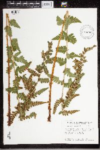 Dryopteris cristata (L.) A. Gray 896505[1324109]Smith, Welby 157661989-07-17 United States, Minnesota, Benton, Sartell Wildlife Management Area. Benton County ... Sartell State Wildlife Management Agea [sic], about 3 miles north-northeast of Rice ...NW1/4 NW1/4 section 15, T38N R 31W. 038N 31W 15, 45.7933333 -94.1947222 |
MIN:Plants | 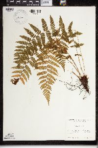 Dryopteris NULL 520405[1324417]Lawrence, Donald s.n.1952-08-23 United States, Alaska, Bartlett Cove.;Glacier Bay National Park;;;, 58.449279 -135.89734 |
MIN:Plants | 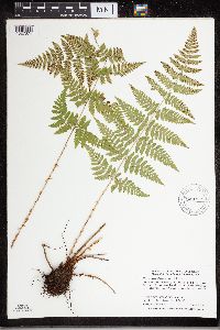 Dryopteris carthusiana (Villars) H.P. Fuchs 908360[1327874]Smith, Welby 289452000-08-09 United States, Minnesota, Saint Louis, St. Louis County...On the south side of Hwy 1 near the Little Fork River crossing...T 62N R 20W SE1/4 of NW1/4 of Sec 16;;062N;20W;16, 47.8591667 -92.9075 |
MIN:Plants |  Dryopteris fragrans (L.) Schott 461301[1305887]Gerdes, Lynden 25871998-06-03 United States, Minnesota, Cook, T65N R01E S27NESW. Cook County; Superior National Forest, BWCAW, Clearwater Lake. Cliff 3.;Boundary Waters Canoe Area Wilderness / Superior National Forest;065N;01E;27, 48.087449 -90.322587 |
MIN:Plants |  Dryopteris expansa (C. Presl) Fraser-Jenkins & Jermy 490520[1305878]Lee, Michael MDL27282000-06-13 United States, Minnesota, Lake, Finland State Forest. Lake County...west of the Manitou River in the Finland State Forest 6-1/2 miles north-northeast of Finland...in slight ravine...[also at] Art Lake. T58N R7W NW1/4 of SE1/4 Sec. 16. 058N 07W 16, 47.570761 -91.213277 |
MIN:Plants |  Dryopteris carthusiana (Villars) H.P. Fuchs 436081[1327806]Smith, Michael 2351996-08-27 United States, Minnesota, Saint Louis, Voyageurs National Park. St. Louis Co.; Plot name: Voya 27 DNR # 5785; 48 35'35" N 93 02'45" W;Voyageurs National Park;071N;21W;, 48.5930557 -93.0458298 |
MIN:Plants |  Dryopteris fragrans (L.) Schott 52207[1324881]Wheeler, William 7721900-08-00 United States, Michigan, Keweenaw, Tobin Harbor, Isle Royale;Isle Royale National Park;;;, 48.010955 -88.828422 |
MIN:Plants |  Dryopteris intermedia (Muhlenberg ex Willdenow) A. Gray 917168[1324360]Gerdes, Lynden 55642008-06-19 United States, Minnesota, Cook, Superior National Forest. T64N R03E S22NWSW. Cook County, MN. Superior National Forest. Approximately 12.25 miles NNW of Hovland, MN and 0.74 miles east of Loft Lake.. 064N 03E 22, 48.0131 -90.04176 |
MIN:Plants |  Dryopteris fragrans (L.) Schott 491421[1324277]Gerdes, Lynden 41712000-07-31 United States, Minnesota, Lake, T57N R07W S13NESE. Lake County ... Finland, MN. Section 13 cliff feature.;North Shore;057N;07W;13, 47.583104 -91.421915 |
MIN:Plants |  Dryopteris carthusiana (Villars) H.P. Fuchs 907784[1327784]Smith, Welby 309822008-07-06 United States, Minnesota, Hennepin, Baker Park Reserve County Park. Hennepin County ... Katrina Lake, in Baker Parker [sic] Reserve, about 2 miles east of Maple Plain ... T118N R23W NW1/4 of NW1/4 of Sec 29. 118N 23W 29, 45.005 -93.6211111 |
MIN:Plants |  Dryopteris fragrans (L.) Schott 52222[1324882]Rosendahl, C. 25761912-08-30 United States, Michigan, Keweenaw, On Monument Rock, Tobin's Harbor, Isle Royale;Isle Royale National Park;;;, 48.010955 -88.828422 |
MIN:Plants |  Dryopteris cristata (L.) A. Gray 220447[1324618]Cooper, William 2911910-09-01 United States, Michigan, Keweenaw, Near Old Camp, Siskowit, Isle Royale;Isle Royale National Park;;;, 48.010955 -88.828422 |
MIN:Plants |  Dryopteris intermedia (Muhlenberg ex Willdenow) A. Gray 461300[1324370]Gerdes, Lynden 27671998-06-22 United States, Minnesota, Cook, T64N R01E S04SESE. Cook County; Superior National Forest, BWCAW. North of the NW portion of Alder Lake.;Boundary Waters Canoe Area Wilderness / Superior National Forest;064N;01E;4, 48.055409 -90.328464 |
MIN:Plants |  Dryopteris fragrans (L.) Schott 548461[1324851]Spetzman, L. 36561951-07-20 United States, Alaska, Arctic North Slope ... Katakturuk River, Ignek Valley.;Arctic National Wildlife Refuge;;;, 69.5833359 -145.5833282, 610m |
MIN:Plants |  Dryopteris carthusiana (Villars) H.P. Fuchs 915927[1327709]Smith, Welby 314912009-09-14 United States, Minnesota, Cook, Boundary Waters Canoe Area Wilderness / Superior National Forest. Cook County...Boundary Waters Canoe Area Wilderness, Superior National Forest. On the south side of the Royal River T 64N R 3E NW1/4 of NE1/4 of Sec 3. 064N 03E 3, 48.0619444 -90.0413889 |
MIN:Plants |  Dryopteris expansa (C. Presl) Fraser-Jenkins & Jermy 52543[1324758]Howell, Thomas 1131902-06-21 United States, Washington, Grays Harbor, Ewell's yard. Quinault;;;;, 47.467031 -123.845455 |
MIN:Plants |  Dryopteris cristata (L.) A. Gray 436444[1324227]Cholewa, A. 22202001-09-28 United States, Minnesota, Sherburne, Sherburne National Wildlife Refuge ... SWNE 13-34-27;Sherburne National Wildlife Refuge;034N;27W;13, 45.490813 -93.721671 |
MIN:Plants |  Dryopteris cristata (L.) A. Gray 907250[1324049]Smith, Welby 308862008-06-12 United States, Minnesota, Benton, Sartell Wildlife Management Area. Benton County...Sartell State Wildlife Management Area, about 5 miles southeast of Royalton...along Little Rock Creek...T 38N R 31W NW1/4 of SW1/4 of Sec 15. 038N 31W 15, 45.7838889 -94.1927778 |
MIN:Plants |  Dryopteris carthusiana (Villars) H.P. Fuchs 906840[1327712]Smith, Welby 309762008-07-04 United States, Minnesota, Hennepin, Hennepin County...Elm Creek Park Reserve, about 4 miles southwest of Anoka...T120N R22W SE1/4 of SE1/4 of Sec 34;Elm Creek Park Reserve County Park;120N;22W;34, 45.155 -93.4455556 |
MIN:Plants | Dryopteris carthusiana (Villars) H.P. Fuchs 474404[1327495]Moore, John 4541971-08-11 United States, Minnesota, Sherburne, NW/4 S - 13 Orrock Tshp.;Sherburne National Wildlife Refuge;034N;27W;13, 45.4333 -93.7333 |
MIN:Plants |  298436[1324731]Tryon, R. 10161935-06-18 United States, Indiana, Porter, Dunes State Park, Porter Co.;Indiana Dunes National Lakeshore;;;, 39.960966 -86.330078 |
MIN:Plants |  Dryopteris expansa (C. Presl) Fraser-Jenkins & Jermy 461253[1305885]Gerdes, Lynden 26571998-06-09 United States, Minnesota, Cook, Boundary Waters Canoe Area Wilderness / Superior National Forest. T65N R02W S26SESE. Cook County; Superior National Forest, BWCAW. North of Hoat Lake, drainage feature running alongside the hiking trail.. 065N 02W 26, 48.084268 -90.544121 |
MIN:Plants |  Dryopteris carthusiana (Villars) H.P. Fuchs 375548[1324513]Tryon, R. 44121940-08-24 United States, Indiana, Porter, County: Porter ... Dunes State Park, 3 miles north of Chesterton.;Indiana Dunes National Lakeshore;;;, 39.960966 -86.330078 |
MIN:Plants |  Dryopteris carthusiana (Villars) H.P. Fuchs 436051[1327809]Smith, Michael 4211997-07-31 United States, Minnesota, Saint Louis, Voyageurs National Park. St. Louis Co.; Plot name: Voya 49; La Bontys Point, UTM 5374536N 497125E;Voyageurs National Park;;;, 48.483546 -92.838098 |
MIN:Plants |  Dryopteris cristata (L.) A. Gray 914964[1324018]Smith, Welby 313222009-06-29 United States, Minnesota, Cook, Cook County...Boundary Waters Canoe Area Wilderness, Superior National Forest...T 63N R 3W NE1/4 of SE1/4 of Sec 6;Boundary Waters Canoe Area Wilderness / Superior National Forest;063N;03W;06, 47.9647222 -90.7486111 |
MIN:Plants |  Dryopteris cristata (L.) A. Gray 508147[1327906]Kaul, R. 26941982-08-16 United States, Minnesota, Clearwater, Clearwater Co.; mouth of Boutwell [sic] Creek, Lake Itasca;Itasca State Park;143N;36W;, 47.197458 -95.201964 |
MIN:Plants |  Dryopteris cristata (L.) A. Gray 507602[1327909]Lee, Michael MDL22371998-07-08 United States, Minnesota, Carver, Carver County ... Marsh Lake Hunting Club 2-1/2 miles south of Victoria ... T116N R24W SE1/4 of SE1/4 Sec. 26;;116N;24W;26, 44.821747 -93.664896 |
MIN:Plants | Dryopteris goldiana (Hooker ex Goldie) A. Gray 429119[1324350]Juhnke, C. United States, Minnesota, Goodhue, Detailed locality information protected. This is typically done to protect rare or threatened species localities. |
MIN:Plants |  Dryopteris carthusiana (Villars) H.P. Fuchs 52473[1324510]Wheeler, William 7941900-08-09 United States, Michigan, Keweenaw, Tobin Harbor, Isle Royale;Isle Royale National Park;;;, 48.010955 -88.828422 |
MIN:Plants |  Dryopteris intermedia (Muhlenberg ex Willdenow) A. Gray 914938[1324367]Smith, Welby 313112009-06-28 United States, Minnesota, Cook, Boundary Waters Canoe Area Wilderness / Superior National Forest. Cook County...Boundary Waters Canoe Area Wilderness Superior National Forest. A peninsula in Long Island Lake...T64N R 4W NE1/4 of SW1/4 of Sec 24. 064N 04W 24, 48.0091667 -90.7819444 |
MIN:Plants |  Dryopteris intermedia (Muhlenberg ex Willdenow) A. Gray 347927[1324983]Burns, J. s.n.1936-05-10 United States, Tennessee, Sevier, Great Smoky Mountains, East Tennessee;Great Smoky Mountains National Park;;;, 35.5833 -83.5 |
MIN:Plants |  Dryopteris cristata (L.) A. Gray 915084[1305867]Smith, Welby 314382009-08-30 United States, Minnesota, Cook, Boundary Waters Canoe Area Wilderness / Superior National Forest. Cook County...Boundary Waters Canoe Area Wilderness, Superior National Forest. Just south of Grassy Lake...T63N R3W NE1/4 of SE1/4 of Sec 2. 063N 03W 2, 47.9655556 -90.6611111 |
MIN:Plants |  Dryopteris fragrans (L.) Schott 491417[1305894]Gerdes, Lynden 40882000-08-18 United States, Minnesota, Lake, T57N R07W S35NWSW. Lake County ... Wolf Ridge Environmental Learning Center, Finland, MN. Raven Lake cliff.;North Shore / Wolf Ridge Environmental Center;057N;07W;35, 47.583104 -91.421915 |
MIN:Plants |  Dryopteris intermedia (Muhlenberg ex Willdenow) A. Gray 915023[1324369]Smith, Welby 313932009-08-27 United States, Minnesota, Cook, Boundary Waters Canoe Area Wilderness / Superior National Forest. Cook County...Boundary Waters Canoe Area Wilderness, Superior National Forest. At the east end of Winchell Lake... T64N R2W SE1/4 of SE1/4 of Sec 26. 064N 02W 26, 47.9936111 -90.5369444 |
MIN:Plants | Dryopteris goldiana (Hooker ex Goldie) A. Gray 914852[1305899]Gerdes, Lynden United States, Minnesota, Itasca, Detailed locality information protected. This is typically done to protect rare or threatened species localities. |
MIN:Plants |  Dryopteris cristata (L.) A. Gray 492515[1327974]Wheeler, Gerald 159921997-06-08 United States, Minnesota, Nicollet, Swan Lake Wildlife Management Area. Nicollet County ... Ca. 4 mi. SSW of Nicollet on Rte. 23; Swan Lake State WMA, North Star Unit ... NW1/4 NW1/4 NE1/4 Sec, 28 T109N R28W. 109N 28W 28, 44.217999 -94.200153 |
MIN:Plants |  Dryopteris fragrans (L.) Schott 220448[1324880]Cooper, William 171909-07-04 United States, Michigan, Keweenaw, Palisades, Isle Royale;Isle Royale National Park;;;, 48.010955 -88.828422 |
MIN:Plants |  Dryopteris intermedia (Muhlenberg ex Willdenow) A. Gray 565333[1324979]Grevatt, J. 2651957-08-20 Canada, Ontario, Ontario. Grey Co. ... (Loc. 41). Rocklyn Creek Falls, 3 mi. NE. of Walter's Falls.;;;;, 44.534444 -80.722778 |
MIN:Plants |  Dryopteris carthusiana (Villars) H.P. Fuchs 906947[1327711]Smith, Welby 309052008-06-12 United States, Minnesota, Morrison, Rice-Skunk Lake Wildlife Management Area. Morrison County...Rice-Skunk Lake State Wildlife Management Area, about 7 miles southeast of Little Falls...T 40N R 31W SE1/4 of NW1/4 of Sec 32. 040N 31W 32, 45.9222222 -94.2344444 |
MIN:Plants |  Dryopteris carthusiana (Villars) H.P. Fuchs 907166[1327528]Smith, Welby 285742000-06-16 United States, Minnesota, Marshall, Thief Lake Wildlife Management Area. Marshall County...Thief Lake State Wildlife Management Area; about 5 miles NE of Gatzke...T158N R39W NW1/4 of SW1/4 of Sec 19. 158N 39W 19, 48.4877778 -95.7297222 |
MIN:Plants |  Dryopteris carthusiana (Villars) H.P. Fuchs 915038[1327710]Smith, Welby 313942009-08-27 United States, Minnesota, Cook, Boundary Waters Canoe Area Wilderness / Superior National Forest. Cook County...Boundary Waters Canoe Area Wilderness, Superior National Forest. At the east end of Winchell Lake... T64N R2W SE1/4 of SE1/4 of Sec 26. 064N 02W 26, 47.9936111 -90.5369444 |
MIN:Plants |  Dryopteris cristata (L.) A. Gray 909276[1324023]Smith, Welby 311682008-08-19 United States, Minnesota, Beltrami, Big Bog State Park. Beltrami County ... Big Bog State Recreation Area, about 9 miles north of Waskish on Highway 72 ... T156N R31W NE1/4 of SW1/4 of Sec 36. 156N 31W 36, 48.2844444 -94.5683333 |
MIN:Plants | 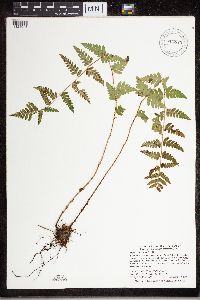 Dryopteris cristata (L.) A. Gray 904523[1324048]Smith, Welby 283061999-09-10 United States, Minnesota, Pine, Pine County...Banning State Park, about 3 miles SW of Askov...Kettle River...T43N R20W NE1/4 of SW1/4 of Sec 35;Banning State Park;043N;20W;35, 46.1630556 -92.8383333 |
MIN:Plants | 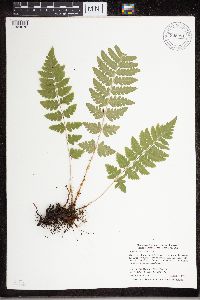 Dryopteris cristata (L.) A. Gray 905281[1324078]Smith, Welby 282321999-08-31 United States, Minnesota, Itasca, Itasca County...About 10 miles south of Nashwauk...T55N R22W NW1/4 of NW1/4 of Sec 29;;055N;22W;29, 47.2241667 -93.1658333 |
MIN:Plants | 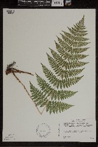 Dryopteris intermedia (Muhlenberg ex Willdenow) A. Gray 491419[1305913]Gerdes, Lynden 42342000-08-17 United States, Minnesota, Lake, T57N R07W S24SENW. Lake County ... Finland, MN. Approximately 0.25 mile south of the Finland Cemetary.;North Shore;057N;07W;24, 47.583104 -91.421915 |
MIN:Plants | 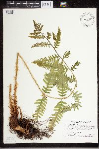 Dryopteris cristata (L.) A. Gray 499845[1324100]Harris, Fred 960171996-05-23 United States, Minnesota, Le Sueur, Le Sueur County ... Ney Environmental Learning Center ... small ravine on east edge of Minnesota River valley ... T 112N R 25W SW1/4 of SE1/4 of sec 6. 112N 25W 6, 44.535994 -93.878951 |
MIN:Plants | 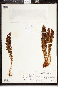 Dryopteris fragrans (L.) Schott 399257[1324853]Spetzman, Lloyd 3241947-07-13 United States, Alaska, Canning River; forks within the mountain.;Arctic National Wildlife Refuge;;;, 69.2166672 -145.8999939 |
MIN:Plants |  Dryopteris fragrans (L.) Schott 401740[1324852]Spetzman, L. 6581948-07-10 United States, Alaska, Arctic North Slope ... mountains west of Lake Schrader.;Arctic National Wildlife Refuge;;;, 68.584069 -144.252214, 1219m |
MIN:Plants | 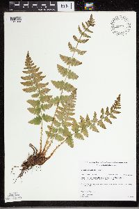 Dryopteris cristata (L.) A. Gray 461272[1327923]Gerdes, Lynden 27461998-06-18 United States, Minnesota, Cook, Superior National Forest. T65N R02W S27SESW. Cook County; Superior National Forest. ENE from the NE corner of Mayhew Lake, approx. 0.4 miles NE of the Gunflint Trail (Cty. 12) on FR 317.. 065N 02W 27, 48.084674 -90.565752 |
MIN:Plants | 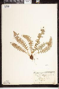 Dryopteris fragrans (L.) Schott 52205[1324877]Wheeler, William 6781900-08-00 United States, Michigan, Keweenaw, Tobin Harbor, Isle Royale;Isle Royale National Park;;;, 48.010955 -88.828422 |
MIN:Plants | 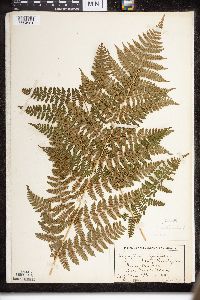 Dryopteris intermedia (Muhlenberg ex Willdenow) A. Gray 52532[1324981]Wheeler, William 6991900-08-00 United States, Michigan, Keweenaw, Tobin Harbor, Isle Royale;Isle Royale National Park;;;, 48.010955 -88.828422 |
MIN:Plants | 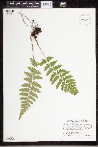 Dryopteris cristata (L.) A. Gray 907257[1324050]Smith, Welby 285752000-06-16 United States, Minnesota, Marshall, Thief Lake Wildlife Management Area. Marshall County...Thief Lake State Wildlife Management Area; about 5 miles NE of Gatzke...T 158 R 39W NW1/4 of SW1/4 of Sec 19. 158N 39W 19, 48.4877778 -95.7297222 |
MIN:Plants | 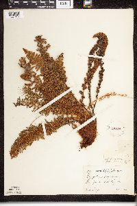 Dryopteris fragrans (L.) Schott 220444[1324876]Cooper, William 2941909-08-06 United States, Michigan, Keweenaw, Nion Rock, Isle Royale;Isle Royale National Park;;;, 48.010955 -88.828422 |
MIN:Plants | 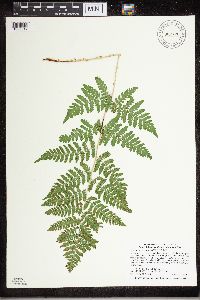 Dryopteris carthusiana (Villars) H.P. Fuchs 907726[1327617]Smith, Welby 312462008-08-21 United States, Minnesota, Beltrami, Red Lake Wildlife Management Area. Beltrami County...At the west end of the road that skirts the north shore of Upper Red Lake, about 12 miles west of Highway 72 in waskish...T 155N R 32W SE1/4 of SW1/4 of Sec 31. 155N 32W 31, 48.1969444 -94.8097222 |
MIN:Plants | 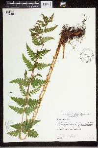 Dryopteris cristata (L.) A. Gray 431646[1324228]Gerdes, Lynden 35071999-06-25 United States, Minnesota, Cook, Superior National Forest. T65N R02W S17SESW. Cook County...Superior National Forest. Wetland adjacent to stream entering the northeastern most bay of Gunflint Lake. Approximately .25 mile south of Canadian border.. 065N 02W 17, 48.11124 -90.609239 |
MIN:Plants |  Dryopteris expansa (C. Presl) Fraser-Jenkins & Jermy 220443[1324756]Cooper, William 3111909-08-09 United States, Michigan, Keweenaw, Greenstone Id, Isle Royale;Isle Royale National Park;;;, 48.010955 -88.828422 |
MIN:Plants |  Dryopteris carthusiana (Villars) H.P. Fuchs 691284[1327620]Lightfoot, J. s.n.1977-08-20 United States, Minnesota, Cook, Cook County...Collected in the NE1/4 of the SE1/4 Sec. 35, T. 60, R. 5;Superior National Forest;060N;05W;35, 47.726653 -90.386005 |
MIN:Plants |  Dryopteris carthusiana (Villars) H.P. Fuchs 447158[1327753]Myhre, K. 50881994-06-29 United States, Minnesota, Itasca, Itasca County...Located one quarter mile east of Buckman Cove in Wabana Lake...T 57N R 25W SE1/4 of SE1/4 of Sec 4;Chippewa National Forest;057N;25W;04, 47.444758 -93.51684 |
MIN:Plants |  Dryopteris carthusiana (Villars) H.P. Fuchs 459678[1327780]Myhre, K. 17051992-05-07 United States, Minnesota, Cass, Cass Co.; Located on the north side of Little Thunder Lake, 1 mile northeast of Thunder Lake; T 140N R 26W SW1/4 of SW1/ Cass Co.; Located on the north side of Little Thunder Lake, 1 mile northeast of Thunder Lake; T 140N R 26W SW1/4 of SW1/4 of Sec 2. 140N 26W 2, 46.965162 -93.940436 |
MIN:Plants | 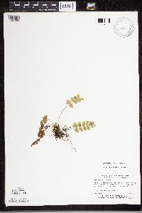 Dryopteris cristata (L.) A. Gray 519596[1324054]Myhre, K. 17061992-05-07 United States, Minnesota, Cass, Cass County...N side of Little Thunder Lake, 1 mile NE of Thunder Lake...T140N R26W SW1/4 of SW1/4 of Sec 2;;140N;26W;02, 46.964752 -93.940436 |
MIN:Plants | 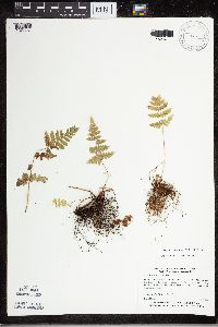 Dryopteris carthusiana (Villars) H.P. Fuchs 520036[1327751]Myhre, K. 16671992-05-05 United States, Minnesota, Cass, Cass County...Located along the Mississippi River in Schoolcraft State Park...T143N R25W SE1/4 of SE1/4 of Sec 2;Schoolcraft State Park;143N;25W;02, 47.224419 -93.799362 |
Google Map
Google Maps is a web mapping service provided by Google that features a map that users can pan (by dragging the mouse) and zoom (by using the mouse wheel). Collection points are displayed as colored markers that when clicked on, displays the full information for that collection. When multiple species are queried (separated by semi-colons), different colored markers denote each individual species.