University of Minnesota
http://www.umn.edu/
612-625-5000
http://www.umn.edu/
612-625-5000
Minnesota Biodiversity Atlas
Bell Museum
Dataset: MIN-Plants
Taxa: Rhynchospora
Search Criteria: excluding cultivated/captive occurrences
Bell Museum plants | |
 MIN:Plants |  Rhynchospora fusca (L.) W.T. Aiton 914503[1021680]Greenlee, Jack 2692009-08-21 United States, Minnesota, Lake, Boundary Waters Canoe Area Wilderness / Superior National Forest. Lake County ... Jitterbug Lake in Boundary Waters Canoe Area Wilderness. On east end of lake ... T64N R8W Section 22 SE1/4, T64N R8W Section 23 SW1/4, T64N R8W Section 27 NE1/4.. 064N 08W 22, 48.012413 -91.339109, 457m |
MIN:Plants |  Rhynchospora alba (L.) Vahl 455748[1021597]Carlson, Bruce 005361999-07-30 United States, Minnesota, Mille Lacs, Mille Lacs Kathio State Park. Mille Lacs Co.; Mille Lacs Kathio State Park, 0.5 miles WNW of the Stark Road dead end. DNR Releve 7645 voucher. T42N R27W SWSW21. 042N 27W 21, 46.106434 -93.755805 |
MIN:Plants | Rhynchospora capillacea Torrey 472650[1021699]Lee, Michael United States, Minnesota, Stearns, Detailed locality information protected. This is typically done to protect rare or threatened species localities. |
MIN:Plants |  Rhynchospora fusca (L.) W.T. Aiton 584087[1021655]Scott, P. 19562005-08-28 United States, Minnesota, Lake, LAKE CO ... Island in N arm of Adams Lake, BWCAW. T64N R6W sec. 30 SENWSE.;Boundary Waters Canoe Area Wilderness / Superior National Forest;064N;06W;30, 48.001026 -91.142466 |
MIN:Plants | Rhynchospora capillacea Torrey 483899[1021634]Anderson, Craig United States, Minnesota, Becker, Detailed locality information protected. This is typically done to protect rare or threatened species localities. |
MIN:Plants |  Rhynchospora fusca (L.) W.T. Aiton 916509[1021682]Anderson, Chel 21072009-08-03 United States, Minnesota, Cook, Cook County...west bay of Bug Lake in BWCAW...T63N R5W Sec. 7 NE1/4 of SE1/4;Boundary Waters Canoe Area Wilderness / Superior National Forest;063N;05W;07, 47.953514 -91.014256 |
MIN:Plants |  Rhynchospora alba (L.) Vahl 920866[1021584]Lee, Michael; et al. MDL35542003-08-27 United States, Minnesota, Todd, Todd County...seven miles northeast of Eagle Bend...southeast of County Ditch #25...T132N R34W E1/2 of SW1/4 sec. 24;;132N;34W;24, 46.230558 -94.905272 |
MIN:Plants |  Rhynchospora fusca (L.) W.T. Aiton 914772[1021689]Gerdes, Lynden; et al. 58452009-07-29 United States, Minnesota, Cook, Boundary Waters Canoe Area Wilderness / Superior National Forest. T65N R05W S36SESW. Cook County. Superior National Forest. Boundary Waters Canoe Area Wilderness. Bat Lake. Small island near southern shore of lake. Along both the NW and SSE-facing shores of island.. 065N 05W 36, 48.0647222 -90.915 |
MIN:Plants |  Rhynchospora fusca (L.) W.T. Aiton 459500[1021662]Gerdes, Lynden 50812005-09-13 United States, Minnesota, Lake, Superior National Forest. T61N R10W S13NENES Lake County ... Superior National Forest. NW of Isabella, MN. Approximately 0.75 miles east of Tonic Lake; east of FR 387; and 0.05 mile NW of an unnamed pond rimmed by an open peatland.. 061N 10W 13, 47.769473 -91.544213 |
MIN:Plants |  Rhynchospora fusca (L.) W.T. Aiton 909913[1021686]Milburn, Scott; et al. SAM08-0162008-07-22 United States, Minnesota, Lake, Lake County...Easting 645,530 Northing 5,288,982 - UTM 15. T 60N R 6W SW Sec 11 [lat/long incorrect];Superior National Forest;060N;06W;11, 47.7377778 -91.0588889 |
MIN:Plants |  Rhynchospora alba (L.) Vahl 493177[1021621]Lee, Michael MDL26891999-08-10 United States, Minnesota, Lake, North Shore. Lake County...Blesner Creek 6-1/2 miles northeast of Finland...along County Road 7, opposite its jct. with the Sonju Lake Forest Road...T58N R6W SW1/4 of NE!/4 of NE1/4 Sec. 31. 058N 06W 31, 47.465115 -91.139684 |
MIN:Plants |  Rhynchospora fusca (L.) W.T. Aiton 438333[1021669]Gerdes, D. Lawson; et al. 6442005-07-14 United States, Minnesota, Lake, Sand Lake Peatland Scientific Natural Area / Superior National Forest. T59N R11W S22SENENW Lake County ... Sand Lake Peatlands SNA (MN DNR). Approximately 27.0 miles north of Two Harbors on Cty Rd 2 to Sand Lake. Small bog pond is 0.28 miles west of Lobo Lake.. 059N 11W 22, 47.582653 -91.709398 |
MIN:Plants |  Rhynchospora alba (L.) Vahl 459517[1021586]Carlson, Bruce Wypt 7712005-08-18 United States, Minnesota, Saint Louis, St. Louis County ... 5.3km east of Hoyt Lakes, 6.3km NW of Skibo, 0.6km NE of the railroad tracks ... T58N R14W NWSENE14;;058N;14W;14, 47.511163 -92.081465 |
MIN:Plants |  Rhynchospora fusca (L.) W.T. Aiton 463590[1021674]Gerdes, Lynden 49282004-08-19 United States, Minnesota, Lake, Superior National Forest. T60N R08W S17S1/2SW Lake County ... Superior National Forest. Approximately 4.58 miles NNW of Isabella, MN and 0.67 mile SE of Tommy Lake.. 060N 08W 17, 47.682199 -91.373542 |
MIN:Plants |  Rhynchospora fusca (L.) W.T. Aiton 913022[1021679]Scott, P. 31242008-08-09 United States, Minnesota, Cook, Cook County ... Copper Lake, BWCAW. T64N R4W sec.10 SWSENW;Boundary Waters Canoe Area Wilderness / Superior National Forest;064N;04W;10, 48.041052 -90.82061 |
MIN:Plants |  Rhynchospora fusca (L.) W.T. Aiton 487912[1021664]Anderson, Chel 9821998-06-30 United States, Minnesota, Cook, In the Superior National Forest, Boundary Waters Canoe Area Wilderness, MN. Along west shore of Grassy Lk.;Boundary Waters Canoe Area Wilderness / Superior National Forest;063N;03W;01, 47.968227 -90.646938 |
MIN:Plants |  Rhynchospora fusca (L.) W.T. Aiton 479340[1021660]Scott, P. 19712005-08-29 United States, Minnesota, Lake, LAKE CO ... By Adams Lake on Adams/Boulder portage, BWCAW. T64N R6W sec.29 NWSENW.;Boundary Waters Canoe Area Wilderness / Superior National Forest;064N;06W;29, 48.000033 -91.121986 |
MIN:Plants | Rhynchospora glomerata (L.) Vahl 82923[]Beardslee, H.; et al. s.n.1891-08-15 United States, North Carolina, Swain, Great Smoky Mountains;Great Smoky Mountains National Park, 518m |
MIN:Plants | Rhynchospora capillacea Torrey 909899[1021636]Milburn, Scott; et al. United States, Minnesota, Polk, Detailed locality information protected. This is typically done to protect rare or threatened species localities. |
MIN:Plants |  Rhynchospora fusca (L.) W.T. Aiton 438222[1021668]Carlson, Bruce Wypt 6752005-07-14 United States, Minnesota, Lake, Sand Lake Peatland Scientific Natural Area / Superior National Forest. Lake County ... Sand Lake Peatland Scientific & Natural Area. 1.6km west of the southern edge of Bonga Lake, 3.6km NW of the Sand Lake canoe access, 2.5km NE of Continental Lake ... T59N R11W NENWSE 15. 059N 11W 15, 47.599788 -91.684127 |
MIN:Plants |  Rhynchospora fusca (L.) W.T. Aiton 462425[1021675]Lee, Michael MDL30362001-07-13 United States, Minnesota, Cook, North Shore. Cook County ... Between Hwy 61 and the Lake Superior shoreline, one mile southwest of Schroeder. Just northeast of mining company property at Taconite Harbor ... T58N R5W SE1/4 of NE1/4 of SW1/4 Sec.1. 058N 05W 1, 47.538323 -90.907999 |
MIN:Plants |  Rhynchospora fusca (L.) W.T. Aiton 916519[1021683]Anderson, Chel 20942009-07-30 United States, Minnesota, Cook, Cook County...Duck Lake in BWCAW...T63N R5W Sec. 12 NW1/4 of SW1/4;Boundary Waters Canoe Area Wilderness / Superior National Forest;063N;05W;12, 47.953189 -90.905255 |
MIN:Plants |  Rhynchospora macrostachya Torrey ex A. Gray 82783[1021701]Chase, Agnes 9101898-08-04 United States, Indiana, Porter, Dune Park;Indiana Dunes National Lakeshore;;;, 41.663093 -87.032128 |
MIN:Plants |  Rhynchospora fusca (L.) W.T. Aiton 898614[1021676]Myhre, K. 098272006-08-22 United States, Minnesota, Lake, Superior National Forest. Lake County,..Shoofly Lake. Located 45 miles northeast of the town of Two Harbors...southeast shore...T 59N R 8W NE1/4 of NW1/4 of Sec 1. 059N 08W 1, 47.63 -91.2938889 |
MIN:Plants |  Rhynchospora alba (L.) Vahl 912073[1021592]Rowe, Erika ERR2612007-06-11 United States, Minnesota, Hubbard, Hubbard County...2.3 miles SE of Nevis; 0.5 mile west of Cty Hwy 119...~17 acre unname lake...T140N R33W NENW S23;;140N;33W;23, 46.9347222 -94.8194444 |
MIN:Plants |  Rhynchospora fusca (L.) W.T. Aiton 438519[1021672]Perry, Ethan 20050302005-07-14 United States, Minnesota, Lake, Lake County...3.5 miles southwest of the Highway 2 bridge over the Sand River...T59N R11W SENW22;Superior National Forest;059N;11W;22, 47.582652 -91.709398 |
MIN:Plants |  Rhynchospora fusca (L.) W.T. Aiton 916505[1021681]Anderson, Chel 20912009-07-12 United States, Minnesota, Cook, Cook County...bay of northeastern arm of Cherokee Lake in BWCAW...T63N R4W Sec. 1 SE1/4 of NW1/4;Boundary Waters Canoe Area Wilderness / Superior National Forest;063N;04W;01, 47.968164 -90.779109 |
MIN:Plants |  Rhynchospora fusca (L.) W.T. Aiton 441158[1021657]Scott, P. 19172005-07-29 United States, Minnesota, Lake, LAKE CO ... Turtle Island Lake near portage to Clearwater Lake, BWCAW. T62N R10W sec.13 SENWNE.;Boundary Waters Canoe Area Wilderness / Superior National Forest;062N;10W;13, 47.855048 -91.543877 |
MIN:Plants |  Rhynchospora fusca (L.) W.T. Aiton 428385[1021661]Scott, P. 14772003-07-28 United States, Minnesota, Cook, COOK CO. ... In Frost River near Octopus Lake, BWCAW. T64N R4W sec.33 SWSWNE.;Boundary Waters Canoe Area Wilderness / Superior National Forest;064N;04W;33, 47.983021 -90.842818 |
MIN:Plants |  Rhynchospora fusca (L.) W.T. Aiton 480932[1021666]Scott, P. 19802005-08-30 United States, Minnesota, Lake, LAKE CO ... Island in Hoe Lake, BWCAW. T64N R6W sec.23 SENENW.;Boundary Waters Canoe Area Wilderness / Superior National Forest;064N;06W;23, 48.011561 -91.056073 |
MIN:Plants | Rhynchospora capillacea Torrey 490680[1021637]Aaseng, N. United States, Minnesota, Roseau, Detailed locality information protected. This is typically done to protect rare or threatened species localities. |
MIN:Plants |  Rhynchospora macrostachya Torrey ex A. Gray 531740[1021702]Umbach, L. 49751909-09-11 United States, Indiana, Porter, Northern Porter County ... Dune Park on Lake Michigan (7 mi. E. of Gary, Ind, SE of Chicago);Indiana Dunes National Lakeshore;;;, 41.663093 -87.032128 |
MIN:Plants |  Rhynchospora fusca (L.) W.T. Aiton 438977[1105257]Myhre, K. 095902004-08-18 United States, Minnesota, Lake, Superior National Forest. Lake County...Elixir Lake. Located 49 miles northeast of the town of Two Harbors. Plants occur along the east shore of the lake...T 60N R 6W SW1/4 of SW1/4 of Sec 30. 060N 06W 30, 47.6455556 -91.1477778 |
MIN:Plants | 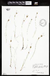 Rhynchospora fusca (L.) W.T. Aiton 916507[1021684]Anderson, Chel 20892009-07-24 United States, Minnesota, Cook, Cook County...south side of Gotter Lake in BWCAW...bay at west end of lake...T65N R4E Sec. 31 SE1/4 of NE1/4;Boundary Waters Canoe Area Wilderness / Superior National Forest;065N;04E;31, 48.070815 -90.883611 |
MIN:Plants | 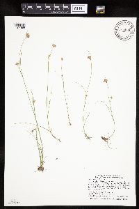 Rhynchospora alba (L.) Vahl 915056[1021585]Smith, Welby; et al. 314052009-08-28 United States, Minnesota, Cook, Boundary Waters Canoe Area Wilderness / Superior National Forest. Cook County...Boundary Waters Canoe Area Wilderness, Superior National Forest...unnamed lake/pond between Wanihigan and Mulligan Lakes...T 63N R 3W NW1/4 of SE1/4 of Sec 1. 063N 03W 1, 47.9655556 -90.6427778 |
MIN:Plants | 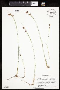 Rhynchospora fusca (L.) W.T. Aiton 914811[1021688]Gerdes, Lynden; et al. 58352009-07-27 United States, Minnesota, Cook, Boundary Waters Canoe Area Wilderness / Superior National Forest. T64N R05W S08NWSW. Cook County. Superior National Forest. Boundary Waters Canoe Area Wilderness. Little Saganaga Lake. Southern side of island in northeastern portion of lake.. 064N 05W 8, 48.0405556 -90.9997222 |
MIN:Plants | 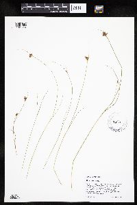 Rhynchospora fusca (L.) W.T. Aiton 480927[1021659]Scott, P. 19942005-09-01 United States, Minnesota, Lake, LAKE CO ... Burl Lake, BWCAW. T64N R6W sec.22 SESWSE.;Boundary Waters Canoe Area Wilderness / Superior National Forest;064N;06W;22, 48.012648 -91.07769 |
MIN:Plants |  Rhynchospora chalarocephala Fernald & Gale 444331[1106805]Anonymous BKE (17) United States, Florida, Volusia, [no further data] |
MIN:Plants |  Rhynchospora fusca (L.) W.T. Aiton 438795[1021670]Gerdes, D. Lawson; et al. 6482005-08-08 United States, Minnesota, Lake, Superior National Forest. T60N R09W S09NESWNE Lake County ... Superior National Forest. Isabella. Approximately 4.0 miles north of Highway 1 on FR177 (Mitawan Lake Rd.) then ~2.0 miles west on FR177E ... On west side of Ova lake.. 060N 09W 9, 47.696967 -91.480415 |
MIN:Plants |  Rhynchospora alba (L.) Vahl 435381[1021599]Jones, Judith 99141999-07-26 United States, Minnesota, Lake, Lake County...SWSE Section 13, T58N R11W. UTM 6605 52622;Superior National Forest;058N;11W;13, 47.510477 -91.666435 |
MIN:Plants |  Rhynchospora fusca (L.) W.T. Aiton 438363[1021671]Anderson, Chel 20802005-09-16 United States, Minnesota, Lake, Lake County...T59N R11W Sec. 2 NE1/4 of NE1/4;Superior National Forest;059N;11W;02, 47.625947 -91.687225 |
MIN:Plants |  Rhynchospora fusca (L.) W.T. Aiton 904389[1021677]Gerdes, Lynden 54882007-08-09 United States, Minnesota, Lake, Superior National Forest. T60N R11W S07SWSWNW Lake County ... Superior National Forest. Approximately 7.4 miles ESE of Babbitt ... and 0.11 miles S of FR 178 .. 060N 11W 7, 47.7 -91.7805556 |
MIN:Plants |  Rhynchospora fusca (L.) W.T. Aiton 491216[1021673]Smith, Welby 295172005-08-19 United States, Minnesota, Lake, Boundary Waters Canoe Area Wilderness / Superior National Forest. Lake County ... About 2 miles southwest of Bald Eagle Lake in the Boundary Waters Canoe Area Wilderness, Superior National Forest ... T62N R10W SW1/4 of SW1/4 of Sec 33. 062N 10W 33, 47.8074989 -91.6144409 |
MIN:Plants |  Rhynchospora fusca (L.) W.T. Aiton 897903[1021700]Scott, P. 18562004-08-24 United States, Minnesota, Lake, LAKE CO ... In Bald Eagle Creek Patterned Fen ... BWCAW. T62N R10W sec.33 S1/2.;Boundary Waters Canoe Area Wilderness / Superior National Forest;062N;10W;33, 47.812022 -91.607348 |
MIN:Plants | Rhynchospora capillacea Torrey 479241[1021644]Harris, Fred United States, Minnesota, Le Sueur, Detailed locality information protected. This is typically done to protect rare or threatened species localities. |
MIN:Plants |  Rhynchospora alba (L.) Vahl 778136[1021698]Coffin, Barbara; Engstrom, D. 81-461981-08-10 United States, Wisconsin, Ashland, Ashland County ... T51N, R2W; NW 1/4, Sec.35. Bog Lake, Madeline Island;Apostle Islands National Lakeshore;051N;02W;35 |
MIN:Plants | Rhynchospora capillacea Torrey 483900[1021635]Anderson, Craig United States, Minnesota, Becker, Detailed locality information protected. This is typically done to protect rare or threatened species localities. |
MIN:Plants | Rhynchospora capillacea Torrey 491572[1021638]Whitfeld, T.J.S. United States, Minnesota, Otter Tail, Detailed locality information protected. This is typically done to protect rare or threatened species localities. |
MIN:Plants |  Rhynchospora fusca (L.) W.T. Aiton 479342[1021658]Scott, P. 20072005-09-02 United States, Minnesota, Lake, LAKE CO. Kivaniva Lake in outlet arm, BWCAW. T63N R6W sec.3 NENWNW.;Boundary Waters Canoe Area Wilderness / Superior National Forest;063N;06W;03, 47.969177 -91.079423 |
MIN:Plants |  Rhynchospora fusca (L.) W.T. Aiton 488765[1021665]Gerdes, Lynden 48622004-07-08 United States, Minnesota, Lake, Superior National Forest. T58N R09W S21NWSE. Lake County...Superior National Forest. Approximately 10.47 miles SW of Isabella, MN and 1.47 miles SSW of Spruce Lake.. 058N 09W 21, 47.494712 -91.480265 |
MIN:Plants |  Rhynchospora fusca (L.) W.T. Aiton 914776[1021678]Gerdes, Lynden 57952009-07-14 United States, Minnesota, Cook, Superior National Forest. T64N R02E S14SSESENESE. Cook County. Superior National Forest. Greenwood Lake area. North of FR 313 and approximately 0.23 miles southeast of Tittle Lake.. 064N 02E 14, 48.0236111 -90.1475 |
MIN:Plants |  Rhynchospora fusca (L.) W.T. Aiton 479960[1021656]Scott, P. 19402005-08-26 United States, Minnesota, Lake, LAKE CO ... Island in Kawishiwi River, BWCAW. T63N R7W sec. 12 SENENW.;Boundary Waters Canoe Area Wilderness / Superior National Forest;063N;07W;12, 47.954695 -91.159478 |
MIN:Plants |  Rhynchospora fusca (L.) W.T. Aiton 431296[1021663]Gerdes, Lynden 48092003-08-04 United States, Minnesota, Lake, Superior National Forest. T60N R07W S26SENE. Lake County...Superior National Forest. Approximately 8.75 miles ENE of Isabella, MN and 0.67 mile N of Homestead Lake. Bog pond 0.21 mile NW of the old Wanless Fire Tower.. 060N 07W 26, 47.65283 -91.181886 |
MIN:Plants |  Rhynchospora scirpoides (Torrey) Grisebach 531755[1021704]Umbach, L. 545/991899-09-12 United States, Indiana, Porter, Northern Porter County ... Dune Park on Lake Michigan (7 mi. E. of Gary, Ind, SE of Chicago);Indiana Dunes National Lakeshore;;;, 41.663093 -87.032128 |
MIN:Plants |  Rhynchospora scirpoides (Torrey) Grisebach 82651[1021705]Umbach, L. s.n.1898-09-02 United States, Indiana, Porter, Dune Park;Indiana Dunes National Lakeshore;;;, 41.663093 -87.032128 |
MIN:Plants |  Rhynchospora nitens (Vahl) A. Gray 251083[1021703]Umbach, L. s.n.1899-09-12 United States, Indiana, Porter, Dune Park;Indiana Dunes National Lakeshore;;;, 41.663093 -87.032128 |
MIN:Plants |  Rhynchospora fusca (L.) W.T. Aiton 908538[1021685]Gerdes, Lynden; et al. 56172008-08-06 United States, Minnesota, Saint Louis, Boundary Waters Canoe Area Wilderness / Superior National Forest. T63N R14W S23SWNESE. St. Louis County, MN. Superior National Forest. Boundary Waters Canoe Area Wilderness. Clark Lake...northern shore of narrow bay/drainage at east side of lake.. 063N 14W 23, 47.924059 -92.083556 |
MIN:Plants | Rhynchospora capillacea Torrey 489183[1021639]Smith, Welby United States, Minnesota, Jackson, Detailed locality information protected. This is typically done to protect rare or threatened species localities. |
MIN:Plants |  Rhynchospora alba (L.) Vahl 435108[1021598]Anderson, Chel 99321999-08-05 United States, Minnesota, Cook, Cook Co.; T60N R5W SE 1/4 of NE 1/4 of NW 1/4 of Sec. 23;Superior National Forest;060N;05W;23, 47.666611 -90.927014 |
MIN:Plants |  Rhynchospora alba (L.) Vahl 680131[1021697]Coffin, Barbara 3541976-09-01 United States, Wisconsin, Ashland, Presque Isle Point, Stockton Island, Apostle Islands National Lakeshore;Apostle Islands National Lakeshore;;;, 46.916326 -90.548792 |
MIN:Plants | Rhynchospora capillacea Torrey 472657[1021633]Lee, Michael; et al. United States, Minnesota, Stearns, Detailed locality information protected. This is typically done to protect rare or threatened species localities. |
MIN:Plants |  Rhynchospora fusca (L.) W.T. Aiton 480937[1021667]Scott, P. 19902005-08-31 United States, Minnesota, Lake, LAKE CO ... Makwa Lake near portage to Elton Lake, BWCAW. T64N R6W sec.23 NENESE.;Boundary Waters Canoe Area Wilderness / Superior National Forest;064N;06W;23, 48.011561 -91.056073 |
MIN:Plants |  Rhynchospora fusca (L.) W.T. Aiton 909911[1021687]Milburn, Scott; et al. SAM08-0192008-07-23 United States, Minnesota, Lake, Lake County...Easting 638,474 Northing 5,280,346 - UTM 15. T 60N R 7W SE Sec 24 [lat/long incorrect];Superior National Forest;060N;07W;24, 47.667194 -91.160323 |
MIN:Plants | Rhynchospora capillacea Torrey 498945[1021640]Whitfeld, T.J.S. United States, Minnesota, Kandiyohi, Detailed locality information protected. This is typically done to protect rare or threatened species localities. |
MIN:Plants |  Rhynchospora alba (L.) Vahl 222007[1021620]Rosendahl, C. 53321927-07-30 United States, Minnesota, Anoka, S of Ham Lake.;;032N;23W;, 45.254503 -93.203833 |
MIN:Plants |  Rhynchospora alba (L.) Vahl 224802[1021582]Boe, J.; et al. 980708071998-07-08 United States, Minnesota, Aitkin, Little Dam Lake northeast of Dam Lake & <.5 mile west of Rice Lake National Wildlife Refuge. NW1/4 of NE1/4 of section.;;047N;25W;36, 46.512415 -93.442626 |
MIN:Plants |  Rhynchospora alba (L.) Vahl 306583[1021604]Butters, F.; et al. 62991930-08-26 United States, Minnesota, Cook, Near Grand Portage Harbor. Cook Co.;Grand Portage Indian Reservation / North Shore;063N;06E;, 47.958468 -89.703576 |
MIN:Plants |  Rhynchospora alba (L.) Vahl 345892[1021614]Lakela, Olga 21411937-08-06 United States, Minnesota, Saint Louis, 6 mi. S of Tower on Hwy. 35.;;N;;, 47.71863 -92.274605 |
MIN:Plants |  Rhynchospora alba (L.) Vahl 360551[1021611]Lakela, Olga 39751940-08-07 United States, Minnesota, Saint Louis, Ca. 6 mi. SE of Gilbert, Hwy. 20.;;N;;, 47.427368 -92.374023 |
MIN:Plants |  Rhynchospora alba (L.) Vahl 367054[1021616]Moore, John; Moore, Marjorie 103511938-08-27 United States, Minnesota, Saint Louis, N shore of the NW arm of Auto Lake.;Superior National Forest;N;;, 47.674124 -92.625906 |
MIN:Plants |  Rhynchospora alba (L.) Vahl 378120[1021603]Thatcher, E. s.n.1941-09-06 United States, Minnesota, Crow Wing, Unorganized twp..;;143N;27W;6, 46.236012 -93.799224 |
MIN:Plants |  Rhynchospora alba (L.) Vahl 386133[1021610]Lakela, Olga 56231944-08-03 United States, Minnesota, Saint Louis, A small lake on Sturgeon Lake Road, 25 mi. N of Hibbing.;George Washington State Forest;N;;, 47.789032 -92.937689 |
MIN:Plants |  Rhynchospora alba (L.) Vahl 407269[1021609]Lakela, Olga 93691949-08-14 United States, Minnesota, Saint Louis, Fredenburg Lake.;;N;;, 46.987037 -92.191099 |
MIN:Plants |  Rhynchospora alba (L.) Vahl 417505[1021608]Lakela, Olga 121011950-09-08 United States, Minnesota, Saint Louis, Sturgeon Lake Road, N of the tower, ca. 25 mi. N of Hibbing.;George Washington State Forest;N;;, 47.742432 -92.868791 |
MIN:Plants |  Rhynchospora alba (L.) Vahl 417512[1021605]Lakela, Olga 110421950-08-03 United States, Minnesota, Saint Louis, Near Wahlsten Station on hwy. 35, S of Tower.;;N;;, 47.735756 -92.283501 |
MIN:Plants |  Rhynchospora alba (L.) Vahl 429519[1021578]Scott, P. 8161995-08-08 United States, Minnesota, Cook, Cook Co. Grand Marais Fen. T61N R1E sec. 18 NNE.;North Shore / Superior National Forest;061N;01E;18, 47.766516 -90.371716 |
MIN:Plants |  Rhynchospora alba (L.) Vahl 436577[1021577]Myhre, K. 5168A1994-07-05 United States, Minnesota, Itasca, Itasca Co.; located 2.7 miles southwest of the town of Bigfork; T 60N R 26W SW1/4 of SW1/4 of sEc 5;Chippewa National Forest;060N;26W;5, 47.713566 -93.673252 |
MIN:Plants |  Rhynchospora alba (L.) Vahl 439923[1021581]Myhre, K. 44081993-08-08 United States, Minnesota, Pine, Pine Co. Located 6 mi NE of the town of Bruno; T44N R17W SW1/4 of SE1/4 of Sec 7;;044N;17W;7, 46.309418 -92.541551 |
MIN:Plants |  Rhynchospora alba (L.) Vahl 442563[1021606]Lakela, Olga 134981951-07-24 United States, Minnesota, Saint Louis, In a small lake S of Tower, Wahlsten Station, Hwy. 35.;;N;;, 47.735756 -92.283501 |
MIN:Plants |  Rhynchospora alba (L.) Vahl 443166[1021607]Lakela, Olga 129081951-07-09 United States, Minnesota, Saint Louis, Hwy. 53, N of Sand Lake.;Superior National Forest;N;;, 47.648931 -92.635203 |
MIN:Plants |  Rhynchospora alba (L.) Vahl 443838[1021588]Myhre, K. 5177A1994-07-05 United States, Minnesota, Itasca, Itasca Co.; Located one quarter mile north of Joel Lake; T 60N R 26W SE1/4 of SW1/4 of sec 14;Chippewa National Forest;060N;26W;14, 47.681983 -93.608703 |
MIN:Plants |  Rhynchospora alba (L.) Vahl 445411[1021601]Myhre, K.; et al. 50801994-06-27 United States, Minnesota, Itasca, Itasca County...Located one mile north of Joel Lake; T 60N R 26W NW1/4 of SE1/4 of sec 14;Chippewa National Forest;060N;26W;14, 47.681982 -93.608703 |
MIN:Plants |  Rhynchospora alba (L.) Vahl 445656[1021587]Boe, J. 950707041995-07-07 United States, Minnesota, Cass, Cass Co.; Peterson Lake; T 141N R 27W NE1/4 of NE1/4 of Sec 24;Chippewa National Forest;141N;27W;24, 47.013827 -94.039913 |
MIN:Plants |  Rhynchospora alba (L.) Vahl 446340[1021618]Moore, John; et al. 187701946-07-25 United States, Minnesota, Anoka, Anoka County...In Ham Lake Meadow, 1/2 mi. E of Hwy. 65.;;032N;23W;00, 45.254503 -93.203833 |
MIN:Plants |  Rhynchospora alba (L.) Vahl 455913[1021596]Boe, J.; et al. 980812091998-08-12 United States, Minnesota, Aitkin, Southwest of ridge southwest of Remote Lake; area known locally as the "grass ponds". NW1/4 of SE1/4 of section.;Savanna State Forest;050N;23W;14, 46.817285 -93.221722 |
MIN:Plants |  Rhynchospora alba (L.) Vahl 457209[1021580]Smith, Welby 212341992-08-04 United States, Minnesota, Hennepin, Hennepin Co.; About 1.5 miles southeast of Chanhassen; T 116N R 22W NW1/4 of NE1/4 of Sec 19 Hennepin Co.; About 1.5 miles southeast of Chanhassen; T 116N R 22W NW1/4 of NE1/4 of Sec 19.. 116N 22W 19, 44.8463898 -93.5077744 |
MIN:Plants |  Rhynchospora alba (L.) Vahl 459490[1021602]Smith, Welby 163041989-08-30 United States, Minnesota, Kanabec, Kanabek [sic] Co.; about 17 mi N-NE of Mora; NW1/4 NW1/4 sec.14, T42N R22W;;042N;22W;14, 46.1286125 -93.0930557 |
MIN:Plants |  Rhynchospora alba (L.) Vahl 462655[1021615]Ahlgren, Clifford 19141952-08-18 United States, Minnesota, Saint Louis, Long Lake.;Boundary Waters Canoe Area Wilderness / Superior National Forest;N;;, 47.967669 -92.191235 |
MIN:Plants |  Rhynchospora alba (L.) Vahl 466736[1021583]Smith, Michael 5191997-08-12 United States, Minnesota, Koochiching, East Rat Root River Peatland Scientific Natural Area. Voyageurs National Park. Koochiching Co.; Rat Root Peatland SNA [this SNA is not in the Park at this time], UTM 436450E 537236N. 069N 22W , 48.496624 -93.185804 |
MIN:Plants |  Rhynchospora alba (L.) Vahl 504974[1021595]Smith, Welby 188461991-06-20 United States, Minnesota, Lake, Superior National Forest. Lake County...about 16 mi NW of Isabella and about 1 mi W of Highway 1 on FR 424 (Denley Road); T60N R11W SW1/4 of SE1/4 of Sec 1. 060N 11W 1, 47.7075005 -91.6619415 |
MIN:Plants |  Rhynchospora alba (L.) Vahl 519321[1021594]Scott, P. 9041996-08-16 United States, Minnesota, Cook, Cook Co. Fiddle Pond T63NR1W sec.2 NSW.;Superior National Forest;063N;01W;2, 47.968892 -90.415147 |
MIN:Plants | 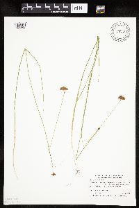 Rhynchospora alba (L.) Vahl 519345[1021600]Myhre, K. 72701997-08-25 United States, Minnesota, Kanabec, Kanabec Co.; Thumb Lk/Fourteen Lk. Located 20 miles northeast of the town of Mora; north shore of the lake; T 42N R 22W Kanabec Co.; Thumb Lk/Fourteen Lk. Located 20 miles northeast of the town of Mora; north shore of the lake; T 42N R 22W NW1/4 of NW1/4 of sec 14. 042N 22W 14, 46.121977 -93.085737 |
MIN:Plants | 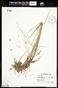 Rhynchospora alba (L.) Vahl 520212[1021579]Smith, Welby 194581991-07-15 United States, Minnesota, Aitkin, Savanna Portage State Park. Aitkin Co.; Savanna Portage State Park, along path around the N side of Loon Lake; T50N R23W SE1/4 SE1/4 of Sec 12 Aitkin Co.; Savanna Portage State Park, along path around the N side of Loon Lake; T50N R23W SE1/4 of SE1/4 of Sec 12. 050N 23W 12, 46.8280563 -93.191391 |
MIN:Plants | 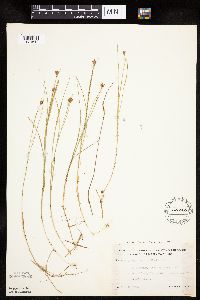 Rhynchospora alba (L.) Vahl 525868[1021612]Lakela, Olga 188301955-07-14 United States, Minnesota, Saint Louis, S of Island Lake; Cloquet River flowage area, Hwy. 4.;;N;;, 47.01631 -92.18559 |
MIN:Plants | 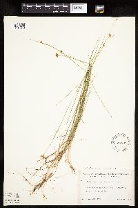 Rhynchospora alba (L.) Vahl 526839[1021613]Lakela, Olga 182641954-08-20 United States, Minnesota, Saint Louis, Finberg Lake, Hwy. 73 N of Floodwood Lake.;;054N;21W;, 47.201888 -93.006033 |
MIN:Plants |  Rhynchospora alba (L.) Vahl 603180[1021619]Thieret, J. 275811967-07-10 United States, Minnesota, Clearwater, Miss Gibson's Bog, S side of hwy, ca. 6 mi. W of Zerkel along the road to Mahnomen.;;N;;, 47.31072 -95.509785 |
MIN:Plants |  Rhynchospora alba (L.) Vahl 669745[1021617]Wheeler, Gerald s.n.1975-07-07 United States, Minnesota, Saint Louis, 3 mi. SE of the jct. of the main road to the Dunka Mine (Erie Mining Co.) and the Reserve Mining Co. railroad tracks; ne 3 mi. SE of the jct. of the main road to the Dunka Mine (Erie Mining Co.) and the Reserve Mining Co. railroad tracks; near Babbitt.. N , 47.65706 -91.81832 |
MIN:Plants |  Rhynchospora alba (L.) Vahl 681749[1021591]Wheeler, Gerald 11991977-07-08 United States, Minnesota, Beltrami, Ca. 13 mi. N of Waskish on Hwy. 72.;Red Lake Peatland Scientific Natural Area;156N;31W;1, 48.359967 -94.564698 |
MIN:Plants |  Rhynchospora alba (L.) Vahl 681760[1021622]Wheeler, Gerald 11901977-07-08 United States, Minnesota, Lake of the Woods, Ca. 15 mi. N of Waskish on hwy. 72. 1/8 mi. W of the road.;;157N;31W;36, 48.374576 -94.570252 |
MIN:Plants | 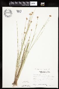 Rhynchospora alba (L.) Vahl 687520[1021589]Wheeler, Gerald; Glaser, Paul 19621977-07-09 United States, Minnesota, Itasca, Ca. 11 mi. N-NE of Grand Rapids.;;057N;25W;22, 47.406623 -93.504033 |
Google Map
Google Maps is a web mapping service provided by Google that features a map that users can pan (by dragging the mouse) and zoom (by using the mouse wheel). Collection points are displayed as colored markers that when clicked on, displays the full information for that collection. When multiple species are queried (separated by semi-colons), different colored markers denote each individual species.