University of Minnesota
http://www.umn.edu/
612-625-5000
http://www.umn.edu/
612-625-5000
Minnesota Biodiversity Atlas
Bell Museum
Dataset: MIN-Plants
Taxa: Rhamnaceae
Search Criteria: excluding cultivated/captive occurrences
Bell Museum plants | |
 MIN:Plants | 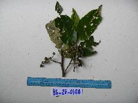 951555[1297687]Weiblen, G.D. YS2G01682010-12-04 Papua New Guinea, Morobe, Yawan Village, -6.1631 146.840217, 1752m |
MIN:Plants | 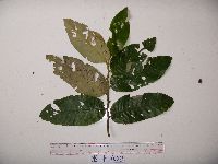 951516[1299315]Weiblen, G.D. YS1F01232010-07-12 Papua New Guinea, Morobe, Yawan Village, -6.16255 146.839933, 1721m |
MIN:Plants | 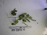 951538[1297704]Weiblen, G.D. YS2J00562012-11-14 Papua New Guinea, Morobe, Yawan Village, -6.164683 146.841717, 1855m |
MIN:Plants | 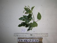 951543[1297699]Weiblen, G.D. YS1K32382012-06-11 Papua New Guinea, Morobe, Yawan Village, -6.163883 146.838333, 1723m |
MIN:Plants | 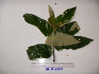 951553[1297689]Weiblen, G.D. YS3F03492010-08-14 Papua New Guinea, Morobe, Yawan Village, -6.16255 146.839933, 1721m |
MIN:Plants | 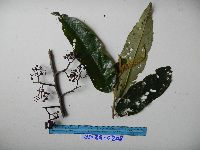 951559[1297683]Weiblen, G.D. YS2G02082010-12-06 Papua New Guinea, Morobe, Yawan Village, -6.1631 146.840217, 1752m |
MIN:Plants | 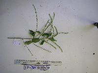 951565[1297678]Weiblen, G.D. YS3H00892012-09-19 Papua New Guinea, Morobe, Yawan Village, -6.1641 146.843567, 1851m |
MIN:Plants | 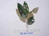 951647[1299240]Weiblen, G.D. YS3G02672011-01-21 Papua New Guinea, Morobe, Yawan Village, -6.1631 146.840217, 1752m |
MIN:Plants |  961380[1334831] United States, California |
MIN:Plants |  961375[1334836] United States, California |
MIN:Plants |  577866[1369620]Troupin, G 117001959-09-06 Rwanda, Region du Mutara, 1400 - 1450m |
MIN:Plants | 939763[]P 682011-07-07 Costa Rica, Guanacaste, Liberia, , 10.84 -85.61, 320m |
MIN:Plants |  Ceanothus diversifolius Kellogg 238073[1057100]Congdon, J. s.n.1894-05-12 United States, California, Mariposa, Footman Mt.;Yosemite National Park;;;, 37.54549 -119.82489 |
MIN:Plants | 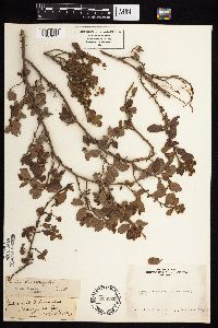 Ceanothus diversifolius Kellogg 238220[1057099]Congdon, J. s.n.1883-06-03 United States, California, Mariposa, Yosemite and Wawona, Mariposa County;Yosemite National Park;;;, 37.55 -119.9 |
MIN:Plants | 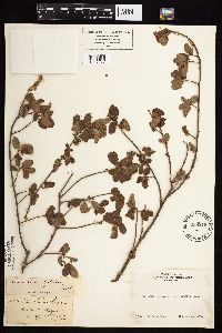 Ceanothus diversifolius Kellogg 238219[1057097]Congdon, J. s.n.1902-05-19 United States, California, Mariposa, Mt. Buckingham, Mariposa County;Yosemite Nationaltional Park;;;, 37.5233 -119.8588 |
MIN:Plants | 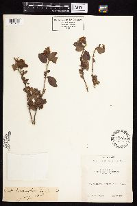 Ceanothus diversifolius Kellogg 238098[1057098]Congdon, J. s.n.1885-05-00 United States, California, Mariposa, Mt. Buckingham, Mariposa County;Yosemite Nationaltional Park;;;, 37.5233 -119.8588 |
MIN:Plants |  Ceanothus diversifolius Kellogg 238144[1057101]Congdon, J. s.n.1886-06-00 United States, California, Mariposa, Footman Mt.;Yosemite National Park;;;, 37.54549 -119.82489 |
MIN:Plants | 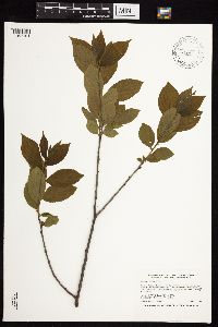 Rhamnus alnifolia L'H̩ritier 438994[1057191]Smith, Welby 261461996-06-11 United States, Minnesota, Saint Louis, St. Louis County ... Superior National Forest ... Little Indian Sioux River ... T65N R15W NW1/4 of NW1/4 of Sec 1;Superior National Forest;065N;15W;01, 48.1486111 -92.2013889 |
MIN:Plants |  Rhamnus alnifolia L'H̩ritier 429019[1057213]Smith, Welby 290942000-09-08 United States, Minnesota, Cook, Superior National Forest. Cook County ... USFS campground at Temperance River; about 6 miles north of Tofte on Co Hwy 2 ... T 60N R 4W SE1/4 of NW1/4 of Sec 33. 060N 04W 33, 47.64 -90.8469444 |
MIN:Plants |  Rhamnus alnifolia L'H̩ritier 482443[1057266]Gerdes, Lynden; et al. 26231998-06-07 United States, Minnesota, Cook, Superior National Forest. T65N R04W S26NWSE. Cook County; Superior National Forest. Cross River riparian zone, east side of river and north of the Gunflint Trail (Cty. 12).. 065N 04W 26, 48.0845 -90.80375 |
MIN:Plants |  Rhamnus alnifolia L'H̩ritier 905851[1057298]Smith, Welby 132631987-06-29 United States, Minnesota, Washington, Washington County...Corries Swamp...about 8 miles west of Marine on St. Croix...NW1/4 SE1/4 section 26, T32N R21W;;032N;21W;26, 45.2161111 -92.9244444 |
MIN:Plants |  Rhamnus alnifolia L'H̩ritier 429049[1057321]Smith, Welby 262541996-07-23 United States, Minnesota, Saint Louis, Cloquet Valley State Forest. St. Louis County ... On the east side of Indian Lake, about one mile north of Rollins ... T 55N R 12W SE1/4 of SW1/4 of Sec 3. 055N 12W 3, 47.2738876 -91.8483353 |
MIN:Plants |  Rhamnus alnifolia L'H̩ritier 472852[1057320]Lee, Michael MDL18471997-07-21 United States, Minnesota, Meeker, Meeker Co.; Straddling the Meeker / Stearns County line two miles south-southeast of Kimball; on north side of Lake Betsy; T121N R29W NE1/4 of NE1/4 of NE1/4 Sec. 23, SE1/4 of SE1/4 of SE1/4 Sec. 14 [Stearns Co.]. 121N 29W 23, 45.27574 -94.2917 |
MIN:Plants |  Rhamnus alnifolia L'H̩ritier 519143[1057194]Lee, Michael; et al. MDL36202004-06-15 United States, Minnesota, Becker, Sucker Creek County Park. Becker County...Sucker Creek Park on the southeast side of Big Detroit Lake, three miles southeast of the city of Detroit Lakes...along Sucker Creek...T138N R41W NW1/4 of NE1/4 sec. 13. 138N 41W 13, 46.76739 -95.80608 |
MIN:Plants |  Rhamnus alnifolia L'H̩ritier 909862[1057264]Smith, Welby 245041994-06-29 United States, Minnesota, Polk, about 3 miles southeast of Mentor...NW1/4 of SE1/4 of Section;Rydell National Wildlife Refuge;148N;43W;02, 47.6625 -96.0977778 |
MIN:Plants |  Rhamnus alnifolia L'H̩ritier 461879[1057214]Smith, Welby 157651989-07-17 United States, Minnesota, Benton, Sartell Wildlife Management Area. Benton County ... Sartell State Wildlife Management Agea [sic],about 3 miles north-northeast of Rice ... NW1/4 NW1/4 section 15, T 38N R 31W. 038N 31W 15, 45.793335 -94.194725 |
MIN:Plants |  Rhamnus alnifolia L'H̩ritier 152172[1057218]Rosendahl, C. 24641910-05-30 United States, Minnesota, Hennepin, Ft. Snelling Reservation [old regional park spanning junction of Minnesota & Mississippi rivers], Deephaven Swamp;;028N;23W;, 44.90516 -93.16646 |
MIN:Plants |  Rhamnus alnifolia L'H̩ritier 152173[1057223]Sheldon, Edmund S19281891-05-00 United States, Minnesota, Hennepin, Lake Calhoun;;N;;, 44.94222 -93.31194 |
MIN:Plants |  Rhamnus alnifolia L'H̩ritier 152175[1057265]Sheldon, Edmund S29951892-07-00 United States, Minnesota, Mille Lacs, Milaca;;037N;27W;, 45.69205 -93.69879 |
MIN:Plants |  Rhamnus alnifolia L'H̩ritier 152176[1127428]Sandberg, John s.n.1890-06-00 United States, Minnesota, Hennepin, [no further data];;N;;, 44.97441 -93.233002 |
MIN:Plants |  Rhamnus alnifolia L'H̩ritier 152177[1057286]Burglehaus, F. s.n.1892-06-00 United States, Minnesota, Hennepin, near Minneapolis;;N;;, 44.98 -93.26361 |
MIN:Plants |  Rhamnus alnifolia L'H̩ritier 152178[1057199]Arthur, J.; et al. B4591886-07-28 United States, Minnesota, Saint Louis, Mud Lake [other collections indicated this was near Lake Vermilion];;062N;14W;03, 47.88109 -92.10443 |
MIN:Plants |  Rhamnus alnifolia L'H̩ritier 152179[1057303]Bergman, H. 30191914-08-11 United States, Minnesota, Hubbard, Benedict, Quadrat 14;;143N;32W;35, 47.15729 -94.6957 |
MIN:Plants |  Rhamnus alnifolia L'H̩ritier 152180[1057261]Bergman, H. 31331914-08-28 United States, Minnesota, Hubbard, Benedict, Quadrat 23;;143N;32W;35, 47.19379 -94.72753 |
MIN:Plants |  Rhamnus alnifolia L'H̩ritier 152181[1057291]Manning, Sara s.n.1886-06-23 United States, Minnesota, Wabasha, near Lake City;;;;, 44.44944 -92.26667 |
MIN:Plants |  Rhamnus alnifolia L'H̩ritier 152182[1057296]Butters, F.; et al. R27661914-06-12 United States, Minnesota, Morrison, W of Randall;;130N;31W;00, 46.09111 -94.50333 |
MIN:Plants |  Rhamnus alnifolia L'H̩ritier 152183[1057179]Butters, F.; et al. R27661914-06-12 United States, Minnesota, Morrison, N of Randall;;130N;30W;06, 46.10016 -94.50478 |
MIN:Plants |  Rhamnus alnifolia L'H̩ritier 152184[1057217]Sheldon, Edmund 16031891-05-00 United States, Minnesota, Hennepin, Lake Calhoun;;N;;, 44.94222 -93.31194 |
MIN:Plants |  Rhamnus alnifolia L'H̩ritier 152185[1057224]Sheldon, Edmund s.n.1891-05-00 United States, Minnesota, Hennepin, Lake Calhoun;;N;;, 44.94222 -93.31194 |
MIN:Plants |  Rhamnus alnifolia L'H̩ritier 152186[1057207]Rosendahl, C. 36931918-08-17 United States, Minnesota, Hubbard, near LaSalle Springs, Itasca Park;Itasca State Park;143N;35W;, 47.1957867 -95.1077892 |
MIN:Plants |  Rhamnus alnifolia L'H̩ritier 152187[1057292]Kassube, J. s.n.1878-05-00 United States, Minnesota, Hennepin, Minneapolis;;N;;, 44.98 -93.26361 |
MIN:Plants |  Rhamnus alnifolia L'H̩ritier 152188[1057245]Sheldon, Edmund S32391892-07-00 United States, Minnesota, Mille Lacs, Milaca;;036N;26W;, 45.60278 -93.57385 |
MIN:Plants |  Rhamnus alnifolia L'H̩ritier 228192[1057284]Butters, F.; et al. 45591924-07-03 United States, Minnesota, Cook, near Pigeon River, N shore Lake Superior. Cook Co.;Grand Portage Indian Reservation / North Shore;;;, 47.99917 -89.56944 |
MIN:Plants |  Rhamnus alnifolia L'H̩ritier 265643[1057187]Stevenson, J. 251912-06-19 United States, Minnesota, Beltrami, Bemidji;;;;, 47.47361 -94.88 |
MIN:Plants |  Rhamnus alnifolia L'H̩ritier 276204[1057247]Grant, Martin 27651929-07-13 United States, Minnesota, Clearwater, Itasca Park, Lake Alice Road, SE-SW-1, T143, R36;Itasca State Park;143N;36W;1, 47.23229 -95.18024 |
MIN:Plants |  Rhamnus alnifolia L'H̩ritier 276898[1057294]Huff, N. 271914-07-02 United States, Minnesota, Lake, North Kawishiwi Riv.;Boundary Waters Canoe Area Wilderness / Superior National Forest;N;;, 47.905455 -91.717359 |
MIN:Plants |  Rhamnus alnifolia L'H̩ritier 277254[1057185]Rosendahl, C. 56841928-07-13 United States, Minnesota, Clearwater, Floating Bog Bay;Itasca State Park;143N;36W;, 47.19557 -95.23322 |
MIN:Plants |  Rhamnus alnifolia L'H̩ritier 345883[1057180]Lakela, Olga 2022a1937-06-29 United States, Minnesota, Saint Louis, about 13 mi N of Duluth, on Vermilion Trail;;N;;, 46.97153 -92.10639 |
MIN:Plants |  Rhamnus alnifolia L'H̩ritier 348402[1057293]Buell, Murray; Buell, Helen 7011933-08-03 United States, Minnesota, Anoka, Decodon Pond;Cedar Creek Natural History Area;034N;23W;27, 45.406779 -93.1937266 |
MIN:Plants |  Rhamnus alnifolia L'H̩ritier 349078[1057189]Swanson, Gustav s.n.1934-06-20 United States, Minnesota, Anoka, Linwood Lake;;033N;22W;00, 45.3514 -93.108354 |
MIN:Plants |  Rhamnus alnifolia L'H̩ritier 356905[1057274]Anonymous 1301912-07-18 United States, Minnesota, Saint Louis, Meadowlands;;N;;, 47.07194 -92.73222 |
MIN:Plants |  Rhamnus alnifolia L'H̩ritier 362451[1057250]Lakela, Olga 36331940-07-04 United States, Minnesota, Cook, Windigo Point, Sea Gull Lake;Boundary Waters Canoe Area Wilderness / Superior National Forest;065N;05W;, 48.149256 -90.887916 |
MIN:Plants |  Rhamnus alnifolia L'H̩ritier 363100[1057269]Bergman, H. 29051913-08-01 United States, Minnesota, Itasca, Deer River;;N;;, 47.33306 -93.7925 |
MIN:Plants |  Rhamnus alnifolia L'H̩ritier 368792[1057252]Lakela, Olga 43251941-05-30 United States, Minnesota, Saint Louis, S of Central Lakes, Hwy 53;;055N;17W;, 47.24135 -92.49312 |
MIN:Plants | 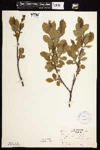 Rhamnus alnifolia L'H̩ritier 370125[1057283]Moore, John; et al. 141311941-05-25 United States, Minnesota, Carlton, W edge of Carlton. Carlton Co.;;;;, 46.66389 -92.42472 |
MIN:Plants | 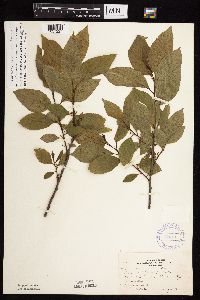 Rhamnus alnifolia L'H̩ritier 370143[1057227]Moore, John; et al. 141141941-05-24 United States, Minnesota, Pine, Rock Creek Twp, N1/4 of section.;Chengwatana State Forest;038N;20W;28, 45.75175 -92.84712 |
MIN:Plants | 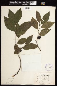 Rhamnus alnifolia L'H̩ritier 371285[1057270]Moore, John; et al. 149931941-08-07 United States, Minnesota, Kanabec, 4 1/2 mi W of Warman. Kanabec Co.;;040N;24W;, 45.94292 -93.32785 |
MIN:Plants | 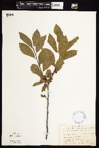 Rhamnus alnifolia L'H̩ritier 385825[1057244]Lakela, Olga 55841944-07-02 United States, Minnesota, Saint Louis, Near Sturgeon Lake, 25 mi N of Hibbing;George Washington State Forest;N;;, 47.77667 -92.86861 |
MIN:Plants |  Rhamnus alnifolia L'H̩ritier 393314[1057242]Lakela, Olga 69051947-07-05 United States, Minnesota, Saint Louis, Terrace of Whiteface River, 1 mi W of Cotton;;;;, 47.16944 -92.4974 |
MIN:Plants |  Rhamnus alnifolia L'H̩ritier 400572[1057184]Butters, F.; Abbe, E.; Burns, G. 6521940-06-30 United States, Minnesota, Cook, on island on W side of South Fowl Lake;Boundary Waters Canoe Area Wilderness / Superior National Forest;064N;03E;, 48.01879 -90.05553 |
MIN:Plants |  Rhamnus alnifolia L'H̩ritier 405311[1057228]Lakela, Olga 80611941-05-21 United States, Minnesota, Saint Louis, Prairie Lake, SW;;050N;20W;, 46.80928 -92.87068 |
MIN:Plants |  Rhamnus alnifolia L'H̩ritier 405447[1057277]Moyle, J.; et al. 37001941-06-29 United States, Minnesota, Fillmore, Fillmore Co, near Wykoff;Dorer Memorial Hardwood State Forest;103N;12W;, 43.71741 -92.26928 |
MIN:Plants |  Rhamnus alnifolia L'H̩ritier 412656[1057295]Moore, John; Moore, Marjorie 110971939-07-24 United States, Minnesota, Lake of the Woods, Angle Inlet;Northwest Angle;168N;34W;, 49.346587 -95.047469 |
MIN:Plants |  Rhamnus alnifolia L'H̩ritier 420735[1057190]Lakela, Olga 108041950-07-24 United States, Minnesota, Saint Louis, Pequaywan Lake Road, south of Rollins, east area of county.;Cloquet Valley State Forest;055N;12W;00, 47.24183 -91.8559 |
MIN:Plants |  Rhamnus alnifolia L'H̩ritier 420893[1057182]Lakela, Olga 106591950-07-06 United States, Minnesota, Saint Louis, Hwy 51, Prairie Lake, SW area of county.;;050N;20W;, 46.80928 -92.87068 |
MIN:Plants |  Rhamnus alnifolia L'H̩ritier 427871[1057233]Jones, George Neville 184491946-07-25 United States, Minnesota, Saint Louis, Armstrong Lake, near Ely, St. Louis County;;062N;14W;14, 47.8521 -92.08324 |
MIN:Plants |  Rhamnus alnifolia L'H̩ritier 430024[1057315]Myhre, K. 22581992-06-17 United States, Minnesota, Cass, Cass Co.; Located 1 mile southwest of Shingobee Bay in Leech Lake; T 141N R 31W SW1/4 of NW1/4 of Sec 15;Chippewa National Forest;141N;31W;15, 47.03193 -94.58725 |
MIN:Plants |  Rhamnus alnifolia L'H̩ritier 440414[1057203]Boe, J. 930604041993-06-04 United States, Minnesota, Cass, Cass Co. Mad Dog Lake Bog; T142N R28W SW1/4 of SE1/4 of Sec 22;Chippewa National Forest / Leech Lake Indian Reservation;142N;28W;22, 47.10445 -94.21412 |
MIN:Plants |  Rhamnus alnifolia L'H̩ritier 441691[1057287]Lee, Michael; et al. MDL7961994-08-11 United States, Minnesota, Fillmore, Fillmore Co.; Along South Branch Root River 2 miles northeast of Cherry Grove; T 102N R 12W NE1/4 of NW1/4 of Sec 27;Dorer Memorial Hardwood State Forest;102N;12W;27, 43.60904 -92.25877 |
MIN:Plants |  Rhamnus alnifolia L'H̩ritier 442326[1057177]Lakela, Olga 127481951-06-27 United States, Minnesota, Saint Louis, Crane Lake terrace near Vermilion River gorge;Superior National Forest;N;;, 48.26667 -92.48833 |
MIN:Plants |  Rhamnus alnifolia L'H̩ritier 443640[1057316]Zager, S. 950608-11995-06-08 United States, Minnesota, Fillmore, Fillmore Co.; on Kedron Springs Creek one mile west of Washington, MN; T104N R13W SE1/4, SE1/4, NE1/4, 35;;104N;13W;35, 43.76828 -92.35883 |
MIN:Plants |  Rhamnus alnifolia L'H̩ritier 444133[1057195]Zager, S.; et al. 950701-41995-07-01 United States, Minnesota, Fillmore, Fillmore Co.; narrow ridge of ancient meander of the Upper Iowa River; T101N R11W SW1/4, SW1/4, SE1/4, 36;;101N;11W;36, 43.50791 -92.09953 |
MIN:Plants |  Rhamnus alnifolia L'H̩ritier 445017[1057238]Moore, John; Huff, N. 194991947-06-11 United States, Minnesota, Itasca, 12 1/2 mi S of Grand rapids;;;;, 47.05796 -93.5376 |
MIN:Plants |  Rhamnus alnifolia L'H̩ritier 445226[1057215]Moore, John; et al. 172511945-06-18 United States, Minnesota, Marshall, Marshall County...2 1/2 mi N of Middle River;;;;, 48.46312 -96.16389 |
MIN:Plants |  Rhamnus alnifolia L'H̩ritier 446393[1057229]Moore, John; Huff, N. 193891947-05-26 United States, Minnesota, Washington, [no further data];William O'Brien State Park;032N;19W;, 45.2517111 -92.7650957 |
MIN:Plants |  Rhamnus alnifolia L'H̩ritier 456264[1057253]Myhre, K. 48931994-06-06 United States, Minnesota, Itasca, Itasca Co.; Located 0.7 mile southeast of Minisogama Lake; T 147N R 29W NE1/4 of SW1/4 of sec 35;Chippewa National Forest / Leech Lake Indian Reservation;147N;29W;35, 47.50784 -94.31794 |
MIN:Plants |  Rhamnus alnifolia L'H̩ritier 457070[1057275]Smith, Welby 131291987-06-24 United States, Minnesota, Pine, Pine Co.; St. Croix State Park; about 70 ft above floodplain of the St. Croix River. NE1/4 SW1/4 sec.31, T 41N R 17W;Saint Croix State Park;041N;17W;31, 45.99063 -92.54166 |
MIN:Plants |  Rhamnus alnifolia L'H̩ritier 481183[1057216]Lakela, Olga 159641953-06-07 United States, Minnesota, Saint Louis, near Treasure Island Resort, Lake Vermilion;;N;;, 47.91056 -92.58944 |
MIN:Plants |  Rhamnus alnifolia L'H̩ritier 481228[1057186]Lakela, Olga 161671953-07-06 United States, Minnesota, Saint Louis, Prairie Lake area;;050N;21W;28, 46.78852 -93.00919 |
MIN:Plants |  Rhamnus alnifolia L'H̩ritier 488633[1057285]Moore, John 199731949-05-23 United States, Minnesota, Fillmore, 1 1/2 mi NW of Wykoff;Dorer Memorial Hardwood State Forest;103N;12W;, 43.71741 -92.26928 |
MIN:Plants |  Rhamnus alnifolia L'H̩ritier 497532[1057226]Moore, John 201991949-06-21 United States, Minnesota, Lake of the Woods, 2 mi SW of Wheeler's Point;;162N;32W;, 48.8443448 -94.7628735 |
MIN:Plants |  Rhamnus alnifolia L'H̩ritier 504981[1057311]Smith, Welby 187161991-06-07 United States, Minnesota, Todd, Todd Co.; about 3.5 mi SW of Motley; T133N R32W NW1/4 of NE1/4 of Sec 27;;133N;32W;27, 46.3088875 -94.7011108 |
MIN:Plants |  Rhamnus alnifolia L'H̩ritier 507429[1057183]Moore, John; et al. 210121951-06-08 United States, Minnesota, Itasca, Coon Lake;Scenic State Park;;;, 47.74694 -93.41444 |
MIN:Plants |  Rhamnus alnifolia L'H̩ritier 508546[1057211]Lee, Michael MDL11271995-08-24 United States, Minnesota, Winona, Winona Co.; along Rush Creek 4 mi SSE of Lewiston; T105N R9W NWSENW 1;Dorer Memorial Hardwood State Forest;105N;09W;1, 43.92622 -91.84919 |
MIN:Plants |  Rhamnus alnifolia L'H̩ritier 508619[1057301]Lee, Michael; et al. MDL8921995-05-17 United States, Minnesota, Fillmore, Forestville State Park. Fillmore Co. Forestville State Park; N-facing slope in tributary ravine of Canfield Creek 1 1/2 mi S of the Forestville Fillmore Co. Forestville State Park; N-facing slope in tributary ravine of Canfield Creek 1 1/2 mi S of the Forestville townsite; T102N R12W SWSWNE 25. 102N 12W 25, 43.60901 -92.21913 |
MIN:Plants |  Rhamnus alnifolia L'H̩ritier 508622[1057235]Lee, Michael; et al. MDL8971995-05-17 United States, Minnesota, Fillmore, Forestville State Park. Fillmore Co. Forestville State Park. 1 3/4 mi NNW of Greenleafton; around bend 1/4 mi upstream from 'Big Spring'; also a Fillmore Co. Forestville State Park. 1 3/4 mi NNW of Greenleafton; around bend 1/4 mi upstream from 'Big Spring'; also above 'Big Spring'; T102N R12W NESWSW 25. 102N 12W 25, 43.60901 -92.21913 |
MIN:Plants |  Rhamnus alnifolia L'H̩ritier 519330[1057236]Scott, P. 8321995-08-10 United States, Minnesota, Cook, Cook Co. by small side stream to N. Brule River at the Gunflint Trail T64NR1E sec.32;Superior National Forest;064N;01E;32, 47.98314 -90.35033 |
MIN:Plants |  Rhamnus alnifolia L'H̩ritier 525628[1057181]Lakela, Olga 189231955-07-21 United States, Minnesota, Saint Louis, Vermilion River gorge 3 mi from Gold Mine Camp;Superior National Forest;;;, 48.27583 -92.50639 |
MIN:Plants |  Rhamnus alnifolia L'H̩ritier 525981[1057230]Lakela, Olga 185751955-05-14 United States, Minnesota, Saint Louis, St. Louis County...Sand Creek, at the bridge, Highway No. 5, Toivola;;;;, 47.16194 -92.78056 |
MIN:Plants |  Rhamnus alnifolia L'H̩ritier 527376[1057178]Lakela, Olga 174471954-06-15 United States, Minnesota, Saint Louis, Ollila's Farm, Pelican Lake, Orr;;N;;, 48.05361 -92.83083 |
MIN:Plants |  Rhamnus alnifolia L'H̩ritier 529129[1057243]Lakela, Olga 196351956-05-30 United States, Minnesota, Saint Louis, West Swan River N of Toivola, Hwy No. 5;;N;;, 47.251047 -92.818249 |
MIN:Plants |  Rhamnus alnifolia L'H̩ritier 532566[1057255]Lakela, Olga 196731956-06-09 United States, Minnesota, Saint Louis, Paleface River, N of Cotton, Hwy 53;;N;;, 47.17806 -92.49722 |
MIN:Plants |  Rhamnus alnifolia L'H̩ritier 533137[1057232]Lakela, Olga 197681956-06-12 United States, Minnesota, Saint Louis, n. of Sturgeon Lake, Highway #5, Morcom T.;Sturgeon River State Forest;060N;21W;00, 47.67592 -92.9968 |
MIN:Plants |  Rhamnus alnifolia L'H̩ritier 536145[1057271]Anderson, W. s.n.1947-08-02 United States, Minnesota, Clearwater, Schoolcraft Island, Lake Itasca, Itasca State Park;Itasca State Park;143N;36W;, 47.19557 -95.23322 |
MIN:Plants |  Rhamnus alnifolia L'H̩ritier 536262[1127424]Aiton, G. s.n.1890-07-00 United States, Minnesota, Hennepin, [no further data];;;;, 45 -93.47 |
MIN:Plants |  Rhamnus alnifolia L'H̩ritier 542418[1057206]Moore, John 215501952-05-20 United States, Minnesota, Koochiching, Koochiching Co.; 7 mi north east of Big Falls;Koochiching State Forest;067N;26W;, 48.28767 -93.67981 |
MIN:Plants |  Rhamnus alnifolia L'H̩ritier 558356[1057282]Moore, John 238381958-06-11 United States, Minnesota, Kittson, 1 mi SW of Lake Bronson;;N;;, 48.72533 -96.67802 |
MIN:Plants |  Rhamnus alnifolia L'H̩ritier 574423[1057239]Moore, John 245231959-05-28 United States, Minnesota, Kittson, 5 mi NW of Lake Bronson;;N;;, 48.77142 -96.69312 |
MIN:Plants |  Rhamnus alnifolia L'H̩ritier 575044[1057225]Wertman, Freida 911960-07-10 United States, Minnesota, Anoka, Cedar Creek Natural History Area; Cedar Lake Bog, S27W, Athens Twp, Coordinates, Map Area Surveyed 1960, 879-2205.8;Cedar Creek National History Area;034N;23W;27, 45.40678 -93.19373 |
MIN:Plants |  Rhamnus alnifolia L'H̩ritier 582117[1057222]McAndrews, John s.n.1963-05-23 United States, Minnesota, Norman, T144N, R43W, S14, NE1/4;;144N;43W;14, 47.28931 -96.09889 |
Google Map
Google Maps is a web mapping service provided by Google that features a map that users can pan (by dragging the mouse) and zoom (by using the mouse wheel). Collection points are displayed as colored markers that when clicked on, displays the full information for that collection. When multiple species are queried (separated by semi-colons), different colored markers denote each individual species.