University of Minnesota
http://www.umn.edu/
612-625-5000
http://www.umn.edu/
612-625-5000
Minnesota Biodiversity Atlas
Bell Museum
Dataset: MIN-Plants
Taxa: Amaranthaceae
Search Criteria: excluding cultivated/captive occurrences
Bell Museum plants | |
 MIN:Plants |  393917[1036963]Nielsen, E. 17131932-09-12 United States, Minnesota, Cook, Second cliff on S side of Clearwater Lake; T65N R1E;Boundary Waters Canoe Area Wilderness / Superior National Forest;065N;01E;, 48.081055 -90.315189 |
MIN:Plants |  405969[1036904]Rosendahl, C. s.n.1948-09-00 United States, Minnesota, Ramsey, St. Anthony Park [neighborhood near U of M], St. Paul;;029N;23W;, 44.992077 -93.166387 |
MIN:Plants |  407196[1036940]Lakela, Olga 93821949-08-14 United States, Minnesota, Saint Louis, Fredenberg Lake;;N;;, 46.987037 -92.191099 |
MIN:Plants |  407382[1036944]Lakela, Olga 97481949-09-12 United States, Minnesota, Saint Louis, S of Ely;;N;;, 47.903237 -91.867087 |
MIN:Plants |  409156[1036925]Moore, John; et al. 113791939-08-02 United States, Minnesota, Roseau, 1.3 mi N of Longworth. Roseau Co.;;;;, 48.993543 -95.365029, 327m |
MIN:Plants |  412687[1036939]Moore, John; et al. 116481939-08-12 United States, Minnesota, Koochiching, Koochiching County...vicinity of the Island View Hotel, T71, R22W, S25...along the S shore of Rainy Lake;Voyageurs National Park;071N;22W;25, 48.609275 -93.099933 |
MIN:Plants |  413628[1036888]Moore, John; et al. 109791939-07-19 United States, Minnesota, Lake of the Woods, Mouth of Pine Creek. Lake of the Woods Co.;Northwest Angle;168N;34W;, 49.344621 -95.028893 |
MIN:Plants |  418863[1036831]Ahlgren, Clifford 5351949-08-09 United States, Minnesota, Lake, Quetico-Superior Wilderness Research Center...Lake Co. Sec. 9 T64N R10W;Boundary Waters Canoe Area Wilderness / Superior National Forest;064N;10W;09, 48.031651 -91.618862 |
MIN:Plants |  419361[1036990]Lakela, Olga 112761950-08-12 United States, Minnesota, Saint Louis, Pequaywan Lake bank, E St. Louis Co.;Cloquet Valley State Forest;N;;, 47.154469 -91.910925 |
MIN:Plants |  420928[1036986]Lakela, Olga 118101950-08-26 United States, Minnesota, Saint Louis, Trail on Lac La Croix, 8 mi W of Curtain Falls;Boundary Waters Canoe Area Wilderness / Superior National Forest;N;;, 48.236433 -92.080077 |
MIN:Plants |  421218[1036983]Lakela, Olga 114181950-08-16 United States, Minnesota, Saint Louis, Resort grounds at Caribou Lake, 14 mi NW of Duluth;;N;;, 46.89813 -92.30987 |
MIN:Plants |  425981[1036876]Moyle, J. s.n.1951-08-15 United States, Minnesota, Roseau, Roseau Bog;;N;;, 48.846093 -95.762766 |
MIN:Plants |  427421[1036847]Darveaux, B. s.n.1991-07-23 United States, Minnesota, Scott, Shakopee, Scott Co. Minnesota Valley Wildlife Refuge. Rt. 101 N.;Minnesota Valley National Wildlife Refuge;115N;23W;1, 44.797739 -93.53047 |
MIN:Plants |  430379[1037014]Scott, P. 10161997-08-13 United States, Minnesota, Cook, Cook Co. Ledges of WSW facing cliff by Moss Lake T65N R1W sec.33 NWNWSW.;Boundary Waters Canoe Area Wilderness / Superior National Forest;065N;01W;33, 48.069998 -90.459508 |
MIN:Plants |  430720[1036899]Smith, Welby 208931992-07-15 United States, Minnesota, Marshall, Old Mill State Park. Marshall County ... In Old Mill State Park, about 11 miles east of Argyle ... T 156N R 46W NW1/4 of SE1/4 of Sec 4. 156N 46W 4, 48.3602791 -96.5702744 |
MIN:Plants |  440843[1036820]Peterson, Jon 1531995-08-05 United States, Minnesota, Scott, Scott. Co. T115N R22W S36 SW of SW. Approx. 0.1 mi N-NE of intersection of State Hwy.13 and Co. Road 44 on N side of hig Scott. Co. T115N R22W S36 SW of SW. Approx. 0.1 mi N-NE of intersection of State Hwy.13 and Co. Road 44 on N side of highway.. 115N 22W 36, 44.724586 -93.409031 |
MIN:Plants |  441842[1036866]Husveth, J. 95-33441995-09-05 United States, Minnesota, Goodhue, Goodhue Co. T113N R16W NE1/4 of the SW1/4 of S25; Cannon River.;Dorer Memorial Hardwood State Forest;113N;16W;25, 44.564811 -92.682382 |
MIN:Plants |  441870[1036965]Nation, R. 94-1671994-06-21 United States, Minnesota, Mower, Lake Louise State Park. Mower Co.; Tract #22B. T101N R14W N1/2 NE1/4 of Sec. 21;Lake Louise State Park;101N;14W;21, 43.536578 -92.519043 |
MIN:Plants |  444021[1036900]Sather, Nancy s.n.1995-08-30 United States, Minnesota, Mahnomen, Mahnomen Co.; southwest of Snider Lake; T143 R40 SESE of Sec 23;White Earth Indian Reservation / White Earth State Forest;143N;40W;23, 47.18676 -95.710493 |
MIN:Plants |  444317[1037009]Gerdes, Lynden; et al. 31801998-08-15 United States, Minnesota, Cook, Boundary Waters Canoe Area Wilderness / Superior National Forest. T65N R01E S21. Cook Co.; Superior National Forest, BWCAW. Watap Lake Cliff. East of large chute-slope feature dividing t T65N R01E S21. Cook Co.; Superior National Forest, BWCAW. Watap Lake Cliff. East of large chute-slope feature dividing the more vertical cliff face.. 065N 01E 21, 48.096662 -90.331204 |
MIN:Plants |  446665[1036941]Moore, John; Huff, N. 178011945-07-23 United States, Minnesota, Morrison, below the dam at Little Falls;;N;;, 45.976354 -94.362502 |
MIN:Plants |  456725[1036844]Smith, Welby 181401990-08-29 United States, Minnesota, Steele, Steele County ... at the E end of Beaver Lake, about 2 mi W-NW of Ellendale ... T105N R21W, NW1/4 of NW1/4 of Sec 22;Beaver Lake County Park;105N;21W;22, 43.8911095 -93.3441696 |
MIN:Plants |  458677[1036828]Puchalski, L. 3261993-07-28 United States, Minnesota, Polk, Polk Co.; Polk WMA. App. 1/3 mi. west of entrance to WMA; T 149N R 41W NW1/4 of SW1/4 of Sec 29;Polk Wildlife Management Area;149N;41W;29, 47.695262 -95.934095 |
MIN:Plants |  460769[1036825]Cholewa, A. 25871999-09-02 United States, Minnesota, Ramsey, Ramsey Co. University of Minnesota St. Paul campus, east end of Facilities Management equipment parking lot on Field Roa Ramsey Co. University of Minnesota St. Paul campus, east end of Facilities Management equipment parking lot on Field Road. T29N R23W sec. 21.. 029N 23W 21, 44.984523 -93.177092 |
MIN:Plants | 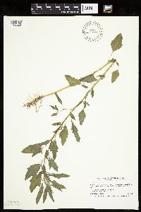 463781[1036949]Smith, Welby 206761992-07-07 United States, Minnesota, Winona, Winona County ... About 2.5 miles east-northeast of Lewiston ... bank of Garvin Brook ... T 106N R 8W, etc.;Dorer Memorial Hardwood State Forest;106N;08W;8, 43.9936104 -91.8125 |
MIN:Plants | 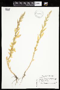 473784[1036823]Smith, Welby 207461992-07-13 United States, Minnesota, Wadena, Wadena County ... Between Trunk Highway 10 and the Burlington Northern railroad tracks, about 3 miles southeast of Wadena ... T 134N R 35W SE1/4 of SW1/4 of Sec 14. 134N 35W 14, 46.4158325 -95.0627747 |
MIN:Plants | 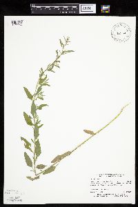 475890[1036868]Myhre, K. 28011992-07-23 United States, Minnesota, Cass, Cass Co.; located on the point in Wa Wa Lake; T 141N R 29W SW1/4 of NW1/4 of sec 15;Chippewa National Forest / Leech Lake Indian Reservation;141N;29W;15, 47.030673 -94.338834 |
MIN:Plants | 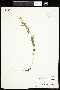 478769[1036818]Myhre, K. 33491992-09-22 United States, Minnesota, Cass, Cass Co.; Located on the north shore of Portage Lake; T 145N R 29W SW1/4 of NW1/4 of sec 25;Chippewa National Forest / Leech Lake Indian Reservation;145N;29W;25, 47.346705 -94.299678 |
MIN:Plants |  501590[1036957]Stevens, O. s.n.1954-09-14 United States, Minnesota, Pipestone, Pipestone Nat. Monument;Pipestone National Monument;106N;46W;, 43.979723 -96.367859 |
MIN:Plants |  514327[1037008]Smith, Welby 155221989-06-30 United States, Minnesota, Chisago, Chisago County ... Interstate State Park, about one mile south of Taylors Falls ... SW1/4 NW1/4 section 36 etc.;Interstate State Park;034N;19W;36, 45.3952789 -92.6688919 |
MIN:Plants |  514382[1036822]Cholewa, A. 25081997-07-31 United States, Minnesota, Anoka, Anoka Co. Ham Lake County Park [now a city park] (in the town of Ham Lake); between ball fields and picnic shelter. T32N R23W sec.21. 032N 23W 21, 45.247884 -93.214062 |
MIN:Plants |  514414[1036845]Smith, Welby 189701991-06-25 United States, Minnesota, Todd, Todd County ... Grey Eagle State Wildlife Management Area, about 3 mi W of Grey Eagle ... T127N R33W, etc.;Grey Eagle Wildlife Management Area;127N;33W;10, 45.8191681 -94.815834 |
MIN:Plants |  514837[1036821]Smith, Welby 191111991-07-08 United States, Minnesota, Koochiching, Koochiching County ... about 6 mi S of Birchdale ... T159N R27W NE1/4 of SE1/4 of sec 34;;159N;27W;34, 48.5475006 -94.082222 |
MIN:Plants |  515021[1036894]Monson, Paul 60881984-08-03 United States, Minnesota, Cook, Grand Portage National Monument; Cook Co.; R-6E, T-63N, S-4, Trail intersect with U.S. Hwy 61;Grand Portage National Monument / North Shore;063N;06E;4, 47.969474 -89.684841 |
MIN:Plants |  515568[1036843]Smith, Welby 180281990-08-22 United States, Minnesota, Steele, Aurora Wildlife Management Area. Steele County ... Aurora State Wildlife Management Area, on the west side of TH 218, about 9 miles southeast of Owatonna ... T 106N R 19W NE1/4 of NW1/4 of Sec 28. 106N 19W 28, 43.9627762 -93.1175003 |
MIN:Plants |  518669[1036842]Darveaux, B. s.n.1991-07-30 United States, Minnesota, Steele, Owatonna, Steele Co. Rt 14 heading east off Hwy 35, near 176 mile marker on left side of road;;107N;20W;, 44.066112 -93.226071 |
MIN:Plants | 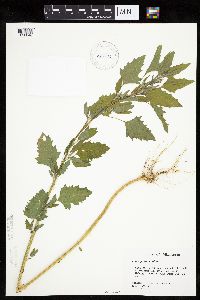 518732[1036848]Darveaux, B. s.n.1991-06-24 United States, Minnesota, Washington, Forest Lake, Anoka Co. [Washington Co.] Left side of exit ramp 129 off of highway 35.;;032N;21W;7, 45.275653 -93.009258 |
MIN:Plants | 519326[]Mell; et al. s.n.1903-08-15 United States, Minnesota, Hubbard, Park Rapids;;;;, 46.922181 -95.058632 |
MIN:Plants | 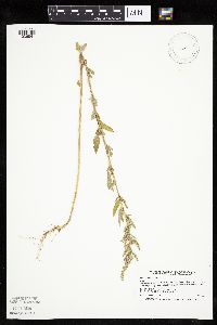 520011[1036841]Smith, Welby 177711990-08-07 United States, Minnesota, Red Lake, Marcoux Wildlife Management Area. Red Lake County ... in Marcoux State Wildlife Management Area, about 5 mi W-SW of Terrebonne ... T 150N R 44W SE1/4 of NE1/4 of Sec 24. 150N 44W 24, 47.793335 -96.2258301 |
MIN:Plants | 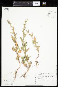 520284[1037012]Smith, Welby 210021992-07-16 United States, Minnesota, Pennington, Pennington County...on the W side of Co. Road 73, about 4.5 mi NW of the center of Thief River Falls...abandoned gravel pit...T154N R44W NE1/4 of NE1/4 of Sec 13. 154N 44W 13, 48.1638889 -96.2405556 |
MIN:Plants | 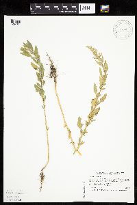 520294[1036824]Smith, Welby 210651992-07-20 United States, Minnesota, Redwood, Cedar Rock Wildlife Management Area. Redwood County ... in Cedar Rock State Wildlife Management Area, about 4 mi N-NW of Redwood Falls ... T 113N R 36W NW1/4 of NW1/4 of Sec 11. 113N 36W 11, 44.6122208 -95.1563873 |
MIN:Plants | 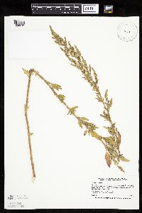 520372[1036846]Smith, Welby 183131990-09-05 United States, Minnesota, Faribault, Osmundson Prairie Scientific Natural Area. Fairbault [sic] County ... Osmundson Prairie State Scientific and Natural Area, about 3 mi SE of Kiester ... T 101N R24W SE1/4 of NE1/4 of Sec 36. 101N 24W 36, 43.5111122 -93.6511078 |
MIN:Plants | 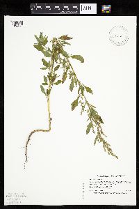 520412[1036827]Smith, Welby 181941990-08-29 United States, Minnesota, Dodge, Pheasants Forever Wildlife Management Area. Dodge County ... 'Pheasants Forever' State Wildlife Management Area, about 2.5 mi W-SW of Mantorville ... T 107N R17W SW1/4 of SE1/4 of Sec 24. 107N 17W 24, 44.0530548 -92.9300003 |
MIN:Plants | 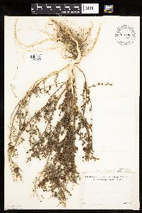 525700[1036973]Lakela, Olga 195721955-09-25 United States, Minnesota, Saint Louis, Minnesota Point, bayside.;Minnesota Point;049N;13W;18, 46.74205 -92.06285 |
MIN:Plants | 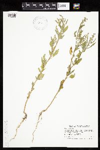 526513[1036849]Smith, Welby 192751991-07-09 United States, Minnesota, Koochiching, Pine Island State Forest. Koochiching County...about 5 miles SW of Big Falls. Along Hickes Ridge Road, about 0.5 mile N of US Highway 71. Abandoned gravel pit...T154N R25W NE1/4 of SW1/4 of Sec 30. 154N 25W 30, 48.1272222 -93.8975 |
MIN:Plants |  526598[1036874]Merrell, Ted s.n.1947-09-28 United States, Minnesota, Rice, Northfield;;N;;, 44.458298 -93.161604 |
MIN:Plants |  533156[1036998]Lakela, Olga 204041956-07-10 United States, Minnesota, Saint Louis, At Island Lake Resort, hwy no. 73, S of Hibbing;;N;;, 47.22677 -93.02845 |
MIN:Plants |  541387[1036980]Scharf, J. 281956-09-05 United States, Minnesota, Murray, Lange Marsh. State-owned marsh. 9 mi. N and 4 mi. W of Lake Wilson.;;N;;, 44.126958 -96.033508 |
MIN:Plants |  552115[1036928]Stevens, O. 20001958-08-21 United States, Minnesota, Clay, Moorhead.;;139N;48W;, 46.845648 -96.728846 |
MIN:Plants |  552140[1037001]Stevens, O. 19961958-08-21 United States, Minnesota, Clay, Moorhead;;N;;, 46.845648 -96.728846 |
MIN:Plants |  558138[1036955]Stevens, O. 21711949-09-27 United States, Minnesota, Clay, Moorhead;;139N;48W;, 46.845648 -96.728846 |
MIN:Plants |  558597[1036943]Moore, John; Hsi, Yu-tseng [Eugene] 234531957-08-09 United States, Minnesota, Waseca, E shore of Lake Elysian;;N;;, 44.171695 -93.69741 |
MIN:Plants |  565151[1036871]Cotter Tucker, Shirley 41821957-08-06 United States, Minnesota, Polk, Along Great Northern rr, E of Northwest School of Agriculture, Crookston;;N;;, 47.796437 -96.621603 |
MIN:Plants |  565214[1036880]Cotter Tucker, Shirley 38301954-09-18 United States, Minnesota, Polk, 2 mi N of Crookston;;N;;, 47.803087 -96.608121 |
MIN:Plants | 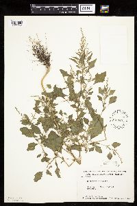 566345[1036932]Moore, John; Bernardini, J. 243081958-09-19 United States, Minnesota, Blue Earth, Mankato;;N;;, 44.163578 -93.9994 |
MIN:Plants | 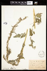 568432[1036898]Oestlund, O. s.n.1886-07-00 United States, Minnesota, Hennepin, Minneapolis;;N;;, 44.979965 -93.263836 |
MIN:Plants | 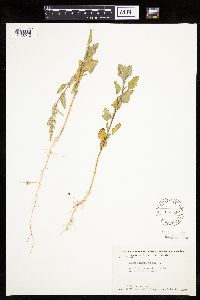 568546[1036942]Moore, John; Archer, A.; Bray, J. 251411960-07-14 United States, Minnesota, Anoka, W of Fish Lake;Cedar Creek National History Area;034N;23W;26, 45.406901 -93.173147 |
MIN:Plants | 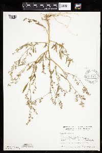 574909[1036961]Wertman, Freida 2401960-08-16 United States, Minnesota, Anoka, Cedar Creek National History Area. Cedar Creek Natural History Area, co. rd 26, W side, coordinated map area surveyed 1960 870.4-2214.6; Bethel Twp. Sec. 2 Cedar Creek Natural History Area, co. rd 26, W side, coordinated map area surveyed 1960 870.4-2214.6; Bethel Twp. Sec. 24 SE1/4. 034N 23W 24, 45.421204 -93.152695 |
MIN:Plants | 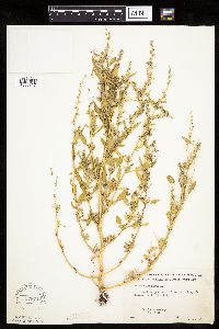 578719[1036857]Ownbey, Gerald 32591962-07-23 United States, Minnesota, Mahnomen, Mahnomen co. Sullivan Lake just E of Waubun. Along old roadway, E side of Lake.;White Earth Indian Reservation;143N;41W;, 47.194255 -95.869088 |
MIN:Plants | 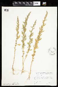 578852[1036987]Ownbey, Gerald 33211962-08-16 United States, Minnesota, Clearwater, Itasca State Park, Douglas Lodge, S end of E arm, Lake Itasca, near pier below lodge; T143N R36W NE1/4 Sec. 24;Itasca State Park;143N;36W;24, 47.188748 -95.180071 |
MIN:Plants | 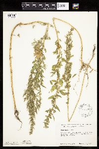 590424[1036962]Ownbey, Gerald 37981965-08-14 United States, Minnesota, Polk, Malmberg Prairie, 2 mi W, 2.5 mi N of Eldred; T149N R48W W1/2 NW1/4 Sec. 16;Malmberg Prairie Scientific Natural Area;149N;48W;16, 47.72417 -96.813965 |
MIN:Plants | 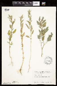 592441[1036989]Westkaemper, Remberta s.n.1964-07-00 United States, Minnesota, Stearns, Stearns Co. St. Joseph, St. Benedict's farm;;124n;29W;, 45.543642 -94.322053 |
MIN:Plants |  595342[1036988]Cahoon, E. 801956-07-08 United States, Minnesota, Brown, At Ochs's Clay pit ca. 1 mi SW of Springfield;;N;;, 44.228606 -94.990117 |
MIN:Plants |  616613[1036984]Moore, John; et al. 2801969-07-12 United States, Minnesota, Crow Wing, Crow Wing Natural History Area. Crow Wing County...Farmstead, N half of SE 1/4 Sec. 18 Garrison Twp.;Crow Wing Natural Area;044N;28W;18, 46.294011 -93.926533 |
MIN:Plants |  670723[1036979]Heitlinger, M. 4511971-10-10 United States, Minnesota, McLeod, Schaefer Prairie, The Nature Conservancy. Schaefer Prairie: SE1/4 of Sec. 34, T115N, R29W. On the S side of a pocket of trees at the N end of a large marshy are Schaefer Prairie: SE1/4 of Sec. 34, T115N, R29W. On the S side of a pocket of trees at the N end of a large marshy area in NE and E central prairie.. 115N 29W 34, 44.72505 -94.30491 |
MIN:Plants |  681410[1036981]Swanson, Steven 22521975-09-09 United States, Minnesota, Houston, Mississippi River (Navigation Pool #8). Houston Co, Site 28. To the W of the r.r. levee.;Upper Mississippi National Wildlife Refuge;N;;, 43.76961 -91.27716 |
MIN:Plants |  685132[1036906]Stassen, Carol 1961977-07-11 United States, Minnesota, Lyon, Camden State Park, near park entrance road; T110N R42W Sec. 5;Camden State Park;110N;42W;5, 44.363181 -95.927443 |
MIN:Plants |  687224[1036975]Wheeler, Gerald; Glaser, Paul 16521977-06-20 United States, Minnesota, Itasca, Site 37. SE1/4 SE1/4 Sec. 20, T55N, R26W; ca. 5.5 mi. W of Grand Rapids.;;055N;26W;20, 47.232566 -93.670603 |
MIN:Plants |  687551[1036974]Wheeler, Gerald; Glaser, Paul 19931977-07-09 United States, Minnesota, Itasca, Site 102. SE1/4 NW1/4 Sec. 26, T57N, R26W; ca. 10.5 mi. NNW of Grand Rapids. Adjacent to Hwy. 233.;;057N;26W;26, 47.393186 -93.610212 |
MIN:Plants |  689729[1036946]Leonard, R. s.n.1950-09-08 United States, Minnesota, Hennepin, Univ. of Minn. Campus;;N;;, 44.97441 -93.233002 |
MIN:Plants |  689980[1036879]Ownbey, Gerald 58021977-08-11 United States, Minnesota, Mahnomen, White Earth Indian Reservation. Mahnomen Co. S side of Minn. rte 200, 10 mi E of its jnc with U.S. rte 59 at Mahnomen; T144N R40W Sec. 4 NE1/4 NW1/4, sh Mahnomen Co. S side of Minn. rte 200, 10 mi E of its jnc with U.S. rte 59 at Mahnomen; T144N R40W Sec. 4 NE1/4 NW1/4, short distance away from the exposed mud flats of a dried up lake. 144N 40W 4, 47.316812 -95.752842 |
MIN:Plants |  695806[1036945]Clemants, Steven 9261977-09-17 United States, Minnesota, Crow Wing, Crosslake, W shore, along roadside. T137N, R27W, NW1/4 S30;;137N;27W;30, 46.653138 -94.145909 |
MIN:Plants | 697551[]Wheeler, Gerald; Glaser, Paul 19931977-07-09 United States, Minnesota, Itasca, Site 102. ca. 10.5 mi. NNW of Grand Rapids. Adjacent to Hwy. 233. SE1/4 NW1/4 Sec.;;057N;26W;26, 47.393186 -93.610212 |
MIN:Plants |  699012[1036863]Sather, Nancy; et al. 5271977-08-26 United States, Minnesota, Lake, Lake Co. N end of White Iron Lake, where it joins Farm Lake. NE1/4 Sec. 35, T63N, R11W.;Superior National Forest;063N;11W;35, 47.898377 -91.695458 |
MIN:Plants |  701427[1036859]Dorio, J. 6081977-07-21 United States, Minnesota, Morrison, Co.: Morrison ... Sandhill Crane Meadow, 4.5 mi. W of Buckman on Hwy. 34. T39N, R31W, Sec. 3 & 4.;Crane Meadows National Wildlife Refuge;039N;31W;, 45.86753 -94.198919 |
MIN:Plants |  709974[1037003]Wheeler, Gerald 50041979-10-06 United States, Minnesota, Le Sueur, Ca. 1 mi SW of Kasota, overlooking the Minnesota River, High Lime Prairie; T109N R26W Sec. 6;East Minnesota River Wildlife Management Area;109N;26W;6, 44.274575 -93.998474 |
MIN:Plants |  712063[1036884]Smith, Welby 10841979-07-15 United States, Minnesota, Wright, Wright Co.; ditch between Soo Line tracks and st. hwy 55, 1.8 mi NW of its jnc with st. hwy 25 in Buffalo; T120N R26W SE Wright Co.; ditch between Soo Line tracks and st. hwy 55, 1.8 mi NW of its jnc with st. hwy 25 in Buffalo; T120N R26W SE1/4 SW1/4 Sec. 13. 120N 26W 13, 45.201291 -93.899596 |
MIN:Plants |  712099[1036886]Smith, Welby 18411979-08-25 United States, Minnesota, Wright, Wright Co.; 0.2 mi NE of co. hwy 75, 4 mi SE of its jnc with st. hwy 24 in Clearwater, between Fish Creek and Burlington Wright Co.; 0.2 mi NE of co. hwy 75, 4 mi SE of its jnc with st. hwy 24 in Clearwater, between Fish Creek and Burlington Northern tracks; T122N R26W NE1/4 SW1/4 Sec. 7. 122N 26W 7, 45.390467 -94.00344 |
MIN:Plants |  715133[1036853]Severson, M. 116A1979-08-13 United States, Minnesota, Polk, 4.5 mi. S of Fischer. W1/2 of NW1/4 of section;Malmberg Prairie Scientific Natural Area;149N;48W;16, 47.72417 -96.813965 |
MIN:Plants |  717084[1036855]Heitlinger, M. 8011975-07-23 United States, Minnesota, Anoka, Helen Allison Savanna Scientific Natural Area. Anoka Co. Allison Savanna. N1/2 NE1/4 of Sec. 2, T33N, R23W. In the NE corner of the old field that lies on the W side Anoka Co. Allison Savanna. N1/2 NE1/4 of Sec. 2, T33N, R23W. In the NE corner of the old field that lies on the W side of the tract.. 033N 23W 2, 45.377702 -93.173879 |
MIN:Plants |  717173[1036854]Heitlinger, M. 8731975-08-14 United States, Minnesota, McLeod, Schaefer Prairie: SE1/4 Sec. 34, T115N, R29W. On the E side of the tract.;Schaefer Prairie, The Nature Conservancy;115N;34W;34, 44.72505 -94.30491 |
MIN:Plants |  717559[1036908]Mathisen, Ron 1351979-08-05 United States, Minnesota, Hubbard, Spearhead Lake Reserve;Spearhead Lake Preserve (Audubon);145N;34W;, 47.368099 -94.990966 |
MIN:Plants |  726350[1036887]Smith, Welby 27041980-07-06 United States, Minnesota, Wright, Wright Co.; on the E side of co. hwy 25, about 1 1/4 mi S of its jnc with st. hwy 12 in Montrose, parking lot; T118N R26 Wright Co.; on the E side of co. hwy 25, about 1 1/4 mi S of its jnc with st. hwy 12 in Montrose, parking lot; T118N R26W SW1/4 Sec. 12. 118N 26W 12, 45.043113 -93.900404 |
MIN:Plants |  730537[1036909]Cross-Cella, J. 3501980-08-12 United States, Minnesota, Wilkin, Western Prairie North, 8 mi N of Rothsay; NW1/4 NE1/4 Sec. 17 T136N R45W;Western Prairie North, The Nature Conservancy;136N;45W;17, 46.594689 -96.376132 |
MIN:Plants |  735517[1036916]Benson, Douglas 2831981-07-20 United States, Minnesota, Wilkin, Town Hall Prairie, near SE corner; T134N R45W NE1/4 SW1/4 Sec. 15;Town Hall Prairie, The Nature Conservancy;134N;45W;15, 46.420332 -96.333183 |
MIN:Plants |  735573[1036910]Benson, Douglas 1841981-07-09 United States, Minnesota, Wilkin, Foxhome Prairie; T133N R45W SW corner NE1/4 SW1/4 NE1/4 Sec. 24;Foxhome Prairie, The Nature Conservancy;133N;45W;24, 46.318653 -96.290714 |
MIN:Plants |  735669[1036914]Benson, Douglas 2561981-07-15 United States, Minnesota, Wilkin, Anna Gronseth Prairie; top of hill; T134N R45W central SE1/4 NW1/4 SE1/4 Sec. 8;Anna Gronseth Prairie, The Nature Conservancy;134N;45W;8, 46.434833 -96.375181 |
MIN:Plants |  738097[1036872]Lounsbury, S. 191977-09-08 United States, Minnesota, Saint Louis, St. Louis Co.; Norton Park, rr bank, St. Louis R. Estuary, Waterfront Trail area, Duluth; R15W T49N Sec. 23;;049N;15W;23, 46.713678 -92.206598 |
MIN:Plants |  739551[1036933]Converse, C. 16691982-07-20 United States, Minnesota, Otter Tail, Otter Tail Preserve: T131N, R44W, NE1/4 NE1/4 S17;Ottertail Prairie Scientific Natural Area;131N;44W;17, 46.159244 -96.235363 |
MIN:Plants |  739661[1036934]Converse, C. 17431982-07-21 United States, Minnesota, Douglas, Staffanson Prairie: T127N, R40W NW1/4 NE1/4 and NE1/4 NW1/4 S18;Staffanson Prairie, The Nature Conservancy;127N;40W;18, 45.810665 -95.748005 |
MIN:Plants |  739781[1036913]Converse, C. 18691982-07-28 United States, Minnesota, Pope, Moe Woods; T123N R36W SW1/4 SW1/4 Sec. 34;Moe Woods, The Nature Conservancy;123N;36W;34, 45.592295 -95.191298 |
MIN:Plants |  739845[1036931]Converse, C. 13671982-06-29 United States, Minnesota, Pope, Ordway Prairie: T123N, R36W, SE1/4 NE1/4 S30;Ordway Prairie, The Nature Conservancy;123N;36W;30, 45.434262 -95.245018 |
MIN:Plants |  741505[1036915]Converse, C. 10871982-06-10 United States, Minnesota, Chippewa, Chippewa and Swift Cos. Chippewa Prairie; T119N R43W SW1/4 SW1/4 Sec. 12;Chippewa Prairie, The Nature Conservancy;119N;43W;12, 45.130213 -95.990566 |
MIN:Plants |  745281[1036856]Smith, Welby 55741981-08-26 United States, Minnesota, Mower, Wild Indigo Scientific Natural Area. Wild Indigo Scientific and Natural Area. Ca. 2 mi. ESE of the jct. of Hwy. 56 and Hwy. 2 in Brownsdale. SE1/4 SE1/4 Se Wild Indigo Scientific and Natural Area. Ca. 2 mi. ESE of the jct. of Hwy. 56 and Hwy. 2 in Brownsdale. SE1/4 SE1/4 Sec. 11, T103N, R17W.. 103N 17W 11, 43.739545 -92.839221 |
MIN:Plants |  745323[1036858]Smith, Welby 48631981-07-18 United States, Minnesota, Wright, Wright Co.; on the NE side of Cokato, between Hwy. 12 and the Burlington Northern R.R. tracks. NE1/4 NE1/4 Sec. 34, T11 Wright Co.; on the NE side of Cokato, between Hwy. 12 and the Burlington Northern R.R. tracks. NE1/4 NE1/4 Sec. 34, T119N, R28W.. 119N 28W 34, 45.072594 -94.185089 |
MIN:Plants |  747000[1036912]Galatowitsch, S. 6131982-08-17 United States, Minnesota, Rice, Rice Co. Trout Lily Preserve: T110N R20W;Cannon River Trout Lily Scientific Natural Area;110N;20W;, 44.326892 -93.221943 |
MIN:Plants |  747401[1036911]Galatowitsch, S. 7941982-09-10 United States, Minnesota, Goodhue, Grace Nature Preserve; T109N R18W NW1/4 SW1/4 and SW1/4 SW1/4 Sec. 8;Grace Nature Preserve, The Nature Conservancy;109N;18W;8, 44.262012 -93.010544 |
MIN:Plants |  753672[1036954]Duxbury, Alexis 23981983-09-05 United States, Minnesota, Nobles, Compass Prairie: part of SE1/4 SW1/4 S3, T101N, R41W;Compass Prairie Scientific Natural Area;101N;41W;3, 43.580108 -95.743853 |
MIN:Plants |  753757[1036926]Duxbury, Alexis 16711983-07-19 United States, Minnesota, Jackson, Blue Gentian Prairie: part of SW1/4 SE1/4 S13, T103N, R36W;Blue Gentian Prairie;103N;36W;13, 43.724929 -95.105077 |
MIN:Plants |  764464[1036875]Foote, Lewis s.n.1893-08-00 United States, Minnesota, Nobles, Worthington;;N;;, 43.619964 -95.596398 |
Google Map
Google Maps is a web mapping service provided by Google that features a map that users can pan (by dragging the mouse) and zoom (by using the mouse wheel). Collection points are displayed as colored markers that when clicked on, displays the full information for that collection. When multiple species are queried (separated by semi-colons), different colored markers denote each individual species.