University of Minnesota
http://www.umn.edu/
612-625-5000
http://www.umn.edu/
612-625-5000
Minnesota Biodiversity Atlas
Bell Museum
Dataset: MIN-Plants
Taxa: Amaranthaceae
Search Criteria: excluding cultivated/captive occurrences
Bell Museum plants | |
 MIN:Plants | 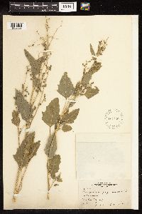 104730[1192095]Bergman, H. F. 1114 United States, North Dakota, Barnes |
MIN:Plants |  943923[1282915]Nee, M. 615042014-08-27 United States, Wisconsin, Grant, Fennimore, eastern outskirts, north of Hwy. Q. T6N;R2W;center of sect.20. Near top of Military Ridge, 42.9825 -90.634167, 337m |
MIN:Plants |  948989[1282914]Dale, Brandon 342014-09-30 United States, Rhode Island, Providence, Swan Point Cemetery, 0.25 miles southeast of Lippet Park. Edge of parking area adjacent to trail along Seekonk River, 41.851528 -71.379 |
MIN:Plants |  953325[1292711]Kaliher, Earl L. s.n.1927-00-00 United States, Minnesota, Todd |
MIN:Plants | 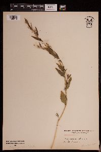 953326[1292710]Kramer, Leona s.n.1927-00-00 United States, Minnesota, Mower |
MIN:Plants | 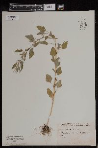 953717[1294566]Friesner, Ray C. 10112 United States, Indiana, Cass |
MIN:Plants | 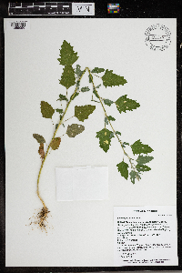 966257[1359096]T. J. S. Whitfeld 27282020-08-13 United States, Minnesota, Washington, Lost Valley Prairie Scientific and Natural Area, 2 miles east north east of intersection of State Highway 95 and 110th Street, at dead-end of Nyberg Avenue South., 44.808484 -92.823327, 299m |
MIN:Plants | 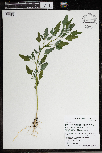 966371[1359210]Timothy J. S. Whitfeld 28402021-07-08 United States, Minnesota, Washington, Lost Valley Prairie Scientific and Natural Area, 2 miles east north east of intersection of State Highway 95 and 110th., 44.7987 -92.82641, 284m |
MIN:Plants |  966486[1359278] 1944-07-28 United States, District of Columbia, Capuchin Monestery |
MIN:Plants | 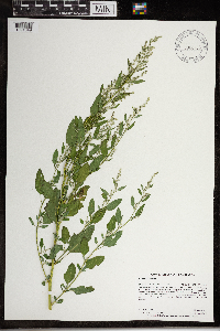 968436[1391049;1391050]Dahlberg, Nathan B. NBD2502020-08-12 United States, Minnesota, Pope, Glacial Lakes State Park. 118 meters east of 295th ave. 10.5 miles southwest of Glenwood., 45.53 -95.53 |
MIN:Plants | 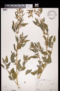 972440[1395989]Janssens, J. 75/2021975-07-22 Belgium, Sint-Job-in-'t-Goor |
MIN:Plants | 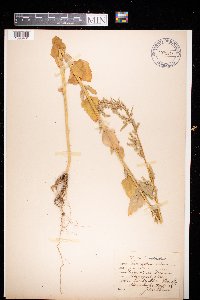 972848[1398401]Julius Persson s.n.1930-07-31 Sweden, Jonkoping, Skeppshult |
MIN:Plants | 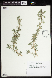 Amaranthus blitoides S. Watson 509593[1343698]Wheeler, Gerald 204411999-08-21 United States, Minnesota, Carver, Ca. 2.5 mi. N of Waconia; N shore of Lake Waconia. S1/2 NE1/4 NW1/4 of section;;116N;25W;01, 44.883671 -93.777773 |
MIN:Plants | 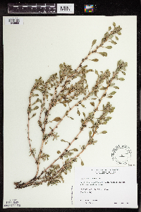 Amaranthus blitoides S. Watson 479027[1343699]Wheeler, Gerald 174841997-08-31 United States, Minnesota, Renville, W side of Bird Island, N side of Rte. 212. N1/2 NW1/4 of section;;115N;34W;14, 44.767523 -94.905151 |
MIN:Plants | Amaranthus blitoides S. Watson 493481[]Went, F. s.n.1939-11-05 United States, California, Yolo, Davis |
MIN:Plants | Amaranthus blitoides S. Watson 911782[]Smith, Welby 252701994-08-25 United States, Minnesota, Jackson, About 8 miles north-northwest of Jackson. NW1/4 of NE1/4 of section;Kilen Woods State Park;103N;35W;17, 43.7255556 -95.0583333 |
MIN:Plants | Amaranthus blitoides S. Watson 246098[]Mearns, E. 29231902-08-07 United States, Wyoming, Park, Yellowstone National Park ... Gardiner River;Yellowstone National Park |
MIN:Plants | Amaranthus blitoides S. Watson 264154[]Holzinger, John s.n.1900-07-00 United States, Minnesota, Winona, [no further data];;;;, 43.963131 -91.691238 |
MIN:Plants | Amaranthus blitoides S. Watson 277721[]Roberts, Thomas s.n.1878-09-13 United States, Minnesota, Hennepin, Minneapolis;;029N;24W;25, 44.969959 -93.237021 |
MIN:Plants | Amaranthus blitoides S. Watson 592200[]Westkaemper, Remberta s.n.1964-06-00 United States, Minnesota, Stearns, St. Joseph, St. Benedict College campus;;124N;29W;10, 45.566172 -94.311699 |
MIN:Plants | Amaranthus blitoides S. Watson 105454[]Rosendahl, C. s.n.1925-08-11 United States, Minnesota, Pipestone, Pipestone;;106N;46W;, 43.979723 -96.367859 |
MIN:Plants | Amaranthus blitoides S. Watson 105455[]Sheldon, Edmund S.38661892-08-00 United States, Minnesota, Otter Tail, Dalton;;;;, 46.173849 -95.915609 |
MIN:Plants | Amaranthus blitoides S. Watson 105456[]Ballard, C. 25431900-08-00 United States, Minnesota, Otter Tail, Fergus Falls;;;;, 46.238762 -96.080589 |
MIN:Plants | Amaranthus blitoides S. Watson 105457[]Taylor, B. T8771891-07-00 United States, Minnesota, Pope, Glenwood;;125N;37W;07, 45.650249 -95.376388 |
MIN:Plants | Amaranthus blitoides S. Watson 105458[]Sheldon, Edmund S15411891-08-00 United States, Minnesota, Lincoln, Lake Benton;;109N;45W;00, 44.24108 -96.26172 |
MIN:Plants | Amaranthus blitoides S. Watson 105459[]Sheldon, Edmund S.34911892-08-00 United States, Minnesota, Douglas, Lake Christina;;;;, 46.090549 -95.736412 |
MIN:Plants | Amaranthus blitoides S. Watson 105460[]Holzinger, John s.n.1886-07-00 United States, Minnesota, Winona, [no further data];;;;, 43.963131 -91.691238 |
MIN:Plants | Amaranthus blitoides S. Watson 105461[]Sandberg, John s.n.1889-08-00 United States, Minnesota, Hennepin, [no further data];;;;, 45 -93.47 |
MIN:Plants | Amaranthus blitoides S. Watson 105462[]Ballard, C. 26581900-08-00 United States, Minnesota, Kittson, St. Vincent;;163N;51W;, 48.945898 -97.210703 |
MIN:Plants | Amaranthus blitoides S. Watson 105463[]Moyer, Lycurgus 14011892-08-21 United States, Minnesota, Chippewa, Montevideo;;117N;40W;, 44.934626 -95.675774 |
MIN:Plants | Amaranthus blitoides S. Watson 105464[]Moyer, Lycurgus 14011892-08-00 United States, Minnesota, Chippewa, Montevideo;;117N;40W;, 44.934626 -95.675774 |
MIN:Plants | Amaranthus blitoides S. Watson 105465[]Aiton, G. s.n.1889-08-00 United States, Minnesota, Hennepin, [no further data];;;;, 45 -93.47 |
MIN:Plants | Amaranthus blitoides S. Watson 336342[]Lakela, Olga 17131936-08-16 United States, Minnesota, Saint Louis, Oatka Beach Addition at 42nd. St, Duluth.;Minnesota Point;049N;13W;18, 46.74205 -92.06285 |
MIN:Plants | Amaranthus blitoides S. Watson 337766[]Buell, Murray; Kukachka, B. 16841937-08-26 United States, Minnesota, Clearwater, New parking place near Elk enclosure.;Itasca State Park;143N;36W;, 47.19557 -95.233216 |
MIN:Plants | Amaranthus blitoides S. Watson 352744[]Seim, A. 101937-06-26 United States, Minnesota, Hennepin, East River Road, S of Pioneer Hall, Minneapolis.;;029N;24W;25, 44.969959 -93.237021 |
MIN:Plants |  Amaranthus blitoides S. Watson 366972[]Moore, John; Moore, Marjorie 102231938-07-03 United States, Minnesota, Dakota, Near the W end of the toll bridge, Inver Grove. ;;027N;22W;, 44.818658 -93.044965 |
MIN:Plants | Amaranthus blitoides S. Watson 412319[]Moore, John; Moore, Marjorie 114861939-08-07 United States, Minnesota, Kittson, At Noyes;;164N;51W;25, 48.995724 -97.205109 |
MIN:Plants | Amaranthus blitoides S. Watson 446667[]Moore, John; Huff, N. 177991945-07-23 United States, Minnesota, Morrison, Below the dam at Little Falls.;;;;, 45.976354 -94.362502 |
MIN:Plants | Amaranthus blitoides S. Watson 524670[]Benner, F.; Benner, J. s.n.1928-08-03 United States, Minnesota, Hennepin, Minneapolis;;029N;24W;25, 44.969959 -93.237021 |
MIN:Plants | Amaranthus blitoides S. Watson 536248[]Aiton, G. s.n.1890-08-00 United States, Minnesota, Hennepin, [no further data];;;;, 45 -93.47412 |
MIN:Plants | Amaranthus blitoides S. Watson 550033[]Moore, John 219391954-07-22 United States, Minnesota, Wilkin, Otter Tail River at Breckenridge.;;132N;47W;, 46.240081 -96.553133 |
MIN:Plants | Amaranthus blitoides S. Watson 572648[]Moore, John; Baker, Gary 254581961-06-21 United States, Minnesota, Houston, At Caledonia.;;102N;06W;, 43.630671 -91.551294 |
MIN:Plants | Amaranthus blitoides S. Watson 584541[]Ownbey, Gerald 36051963-07-30 United States, Minnesota, Becker, Along Highway 113, ca. 3.0 miles west of its junction with U.S. 71, opposite the entracne to De Soto Lake.;;142N;36W;11, 47.130783 -95.201396 |
MIN:Plants | Amaranthus blitoides S. Watson 585326[]Ownbey, Gerald 36051963-07-30 United States, Minnesota, Becker, Along Highway 13, ca. 3.0 mi. W of its junction. with U.S. 71, opposite the entrance to De Soto Lake.;<No data>;142N;36W;11, 47.130783 -95.201396 |
MIN:Plants | Amaranthus blitoides S. Watson 595350[]Cahoon, E. 831956-07-08 United States, Minnesota, Brown, At Och's Clay Pit, about a mile W of Springfield.;;109N;35W;, 44.238678 -95.047715 |
MIN:Plants | Amaranthus blitoides S. Watson 602237[]Westkaemper, Remberta s.n.1963-08-00 United States, Minnesota, Stearns, SBC [St. Benedict College] Campus, St. Joseph.;;124N;29W;10, 45.566172 -94.311699 |
MIN:Plants | 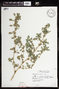 Amaranthus blitoides S. Watson 813056[1343692]Wheeler, Gerald 115341988-07-27 United States, Minnesota, Lac Qui Parle, Ca. 10.5 mi. E of Bellingham; waterfowl area N of Rte. 207. SW1/4 of section;Hastad Wildlife Management Area;119N;43W;05, 45.145667 -96.073076 |
MIN:Plants | Amaranthus blitoides S. Watson 813057[]Wheeler, Gerald 111731988-07-18 United States, Minnesota, Big Stone, Graceville (SW side); about 0.5 mi. W of Rte. 75, East Toqua Lake. Along the SW shore. NW1/4 of section;;124N;46W;16, 45.550417 -96.442385 |
MIN:Plants | Amaranthus blitoides S. Watson 814655[]Wheeler, Gerald 119631988-08-21 United States, Minnesota, Norman, Ca. 1 mi. W of Halstad; S of Rte. 200. Near roadside park. W1/2 NE1/4 of section;;;;, 47.347671 -96.840153 |
MIN:Plants | 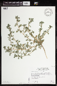 Amaranthus blitoides S. Watson 815962[1343696]Wheeler, Gerald 109081988-06-26 United States, Minnesota, Traverse, Ca. 5.5 mi. SW of Wheaton; wayside park N of Rte. 27. W1/2 NE1/4 of section;;127N;47W;32, 45.767018 -96.604078 |
MIN:Plants | Amaranthus blitoides S. Watson 815966[]Wheeler, Gerald 108401988-06-24 United States, Minnesota, Wilkin, Ca. 5.5 NW of Rothsay. N1/2 NE1/4 of secton;Rothsay Wildlife Management Area;135N;45W;05, 46.536709 -96.375575 |
MIN:Plants | Amaranthus blitoides S. Watson 432670[]Shackleford, Ian 5272001-07-11 United States, Minnesota, Beltrami, Behind Jerry's Produce (502 Paul Bunyan Dr NW, Bemidji);;146N;33W;, 47.453829 -94.863614 |
MIN:Plants | 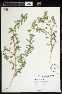 Amaranthus blitoides S. Watson 477245[1343693]Wheeler, Gerald 201731999-08-01 United States, Minnesota, Sibley, W side of Winthrop. NW1/4 of section;;112N;29W;01, 44.536177 -94.260407 |
MIN:Plants | 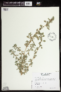 Amaranthus blitoides S. Watson 511099[1343694]Wheeler, Gerald 175021997-08-31 United States, Minnesota, Renville, Ca. 3 mi. W of Bird Island, N side of Rte. 212. N1/2 N1/2 of section;;115N;34W;16, 44.767288 -94.94582 |
MIN:Plants | 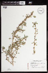 Amaranthus blitoides S. Watson 913933[1343697]Smith, Welby 255041994-09-13 United States, Minnesota, Murray, About 3 miles northwest of Currie. Lake Shetek. SW1/4 of SE1/4 of section;Lake Shetek State Park;107N;40W;31, 44.1111111 -95.7011111 |
MIN:Plants | Amaranthus blitoides S. Watson 911946[]Smith, Welby 218401992-09-03 United States, Minnesota, Watonwan, At the public access on the north side of Fedji Lake, about 2 miles northeast of Madelia. SW1/4 of SW1/4 of section;;107N;30W;12, 44.0816667 -94.3880556 |
MIN:Plants | 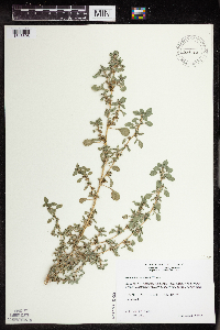 Amaranthus blitoides S. Watson 479082[1343695]Wheeler, Gerald 171721997-08-12 United States, Minnesota, Swift, Ca.10 mi. N of Appleton, NE margin of Rev Marsh. N1/2 NE1/4 NE1/4 of section;;122N;43W;28, 45.348313 -96.066754 |
MIN:Plants |  Zuckia brandegeei (A. Gray) S.L. Welsh & Stutz 595588[1037730]Welsh, Stanley; et al. 35571964-08-15 United States, Utah, Wayne, Wayne Co....Fruita, Capitol Reef National Monument;Capitol Reef National Park |
MIN:Plants | Amaranthus tuberculatus (Moquin-Tandon) J.D. Sauer 581913[]Peterson, Alvin 3521957-09-25 United States, Wisconsin, La Crosse, Lake Onalaska, Town Onalaska;Upper Mississippi National Wildlife Refuge |
MIN:Plants |  Amaranthus tuberculatus (Moquin-Tandon) J.D. Sauer 510766[1343731]Wheeler, Gerald 179361997-09-24 United States, Minnesota, Chippewa, Chippewa County ... Ca. 3 mi. SE of Granite Falls, SW of Pete's Pt. Rd. SE ... SW1/4 SW1/4 NE1/4 Sec. 13 T115N R39W;;115N;39W;13, 44.764995 -95.497564 |
MIN:Plants | Amaranthus tuberculatus (Moquin-Tandon) J.D. Sauer 477002[]Wheeler, Gerald 174621997-08-30 United States, Minnesota, Nicollet, Nicollet County ... Ca. 2.5 mi. NW of Courtland on Rte. 14; Red Rock area ... bordering the Minnesota River ... E1/2 SE1/4 SW1/4 Sec. 34 T110N R30W (Courtland 34). 110N 30W 34, 44.286852 -94.423968 |
MIN:Plants | Amaranthus tuberculatus (Moquin-Tandon) J.D. Sauer 589979[]Wheeler, Gerald 201801999-08-01 United States, Minnesota, Sibley, Sibley County ... W side of Winthrop ... RR tracks ... NW1/4 Sec. 1 T112N R29W (Alfsborg 1) [should be R30W];;112N;30W;1, 44.536081 -94.381769 |
MIN:Plants | Amaranthus tuberculatus (Moquin-Tandon) J.D. Sauer 911756[]Cholewa, A. 27032009-09-01 United States, Minnesota, Scott, Minnesota Valley National Wildlife Refuge. Scott County, Minnesota Valley Wildlife Refuge, Minnesota River at highway 9, Thompson Ferry public boat ramp. T114N R23W Sec 7. 114N 23W 7, 44.694137 -93.630874 |
MIN:Plants |  Amaranthus tuberculatus (Moquin-Tandon) J.D. Sauer 499057[1343734]Budelsky, R. RAB10251998-07-29 United States, Minnesota, Steele, Steele Co, T105N R20W S14;;105N;20W;14, 43.899068 -93.195935 |
MIN:Plants | Amaranthus tuberculatus (Moquin-Tandon) J.D. Sauer 699703[]Ziegler, S.; et al. 30281975-10-01 United States, Wisconsin, La Crosse, Vernon Co.; Island 21; Mississippi Rivermile #695; T15N R7W Sec 17...island E side of main channel;Upper Mississippi National Wildlife Refuge;015N;07W;17, 193m |
MIN:Plants | Amaranthus tuberculatus (Moquin-Tandon) J.D. Sauer 920331[]Smith, Welby 239041993-09-09 United States, Minnesota, Meeker, Meeker County ... About one mile east-southeast of Cedar Mills ... T117 R31W SE1/4 of SE1/4 of Sec 13;;117N;31W;13, 44.9394444 -94.5036111 |
MIN:Plants | Amaranthus tuberculatus (Moquin-Tandon) J.D. Sauer 699693[]Ziegler, S.; et al. 30051975-09-28 United States, Wisconsin, La Crosse, LaCrosse Co.; Island 18; Mississippi Rivermile #693.3; T15N R7W Sec 29...Island on E side of main channel;Upper Mississippi National Wildlife Refuge;015N;07W;29, 193m |
MIN:Plants | Amaranthus tuberculatus (Moquin-Tandon) J.D. Sauer 699702[]Ziegler, S.; et al. 21311975-07-30 United States, Wisconsin, La Crosse, LaCrosse Co.; Island 15; Mississippi Rivermile #691.6; T15N R7W Sec 31...E side of main channel;Upper Mississippi National Wildlife Refuge;015N;07W;31, 193m |
MIN:Plants |  Amaranthus tuberculatus (Moquin-Tandon) J.D. Sauer 478139[1343729]Wheeler, Gerald 203251999-08-17 United States, Minnesota, Carver, Carver County ... Ca. 1.3 mi. SSW of Watertown; where Rte. 25 crosses the South Fork Crow River ... S1/2 SW1/4 NE1/4 Sec. 17 T117n R25W (Watertown 17). 117N 25W 17, 44.941724 -93.858886 |
MIN:Plants | Amaranthus tuberculatus (Moquin-Tandon) J.D. Sauer 540963[]Umbach, L. 51341909-10-09 United States, Indiana, Porter, Northern Porter County...Dune Park on Lake Michigan (7 mi. E. of Gary, Ind, SE of Chicago).;Indiana Dunes National Lakeshore;;;, 41.663093 -87.032128 |
MIN:Plants | Amaranthus tuberculatus (Moquin-Tandon) J.D. Sauer 511127[]Wheeler, Gerald 177691997-09-06 United States, Minnesota, Brown, Brown County ... Ca. 15 mi. NW of Sleepy Eye, Morgan Sportsman Club Recreation Area; along Minnesota River ... N1/2 NW1/4 NW1/4 Sec. 19 T112N R33W (Eden 19). 112N 33W 19, 44.48977 -94.857039 |
MIN:Plants | 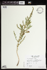 Amaranthus tuberculatus (Moquin-Tandon) J.D. Sauer 511327[1343730]Wheeler, Gerald 178131997-09-18 United States, Minnesota, Renville, Renville County ... Ca. 6 mi. SE of Franklin on rte. 5, S of road; County Park No. 4 ... SW1/4 SE1/4 Sec. 34 T112N R33W;Renville County Park #4;112N;33W;34, 44.459877 -94.799908 |
MIN:Plants | Amaranthus tuberculatus (Moquin-Tandon) J.D. Sauer 699692[]Ziegler, S.; et al. 16541975-07-08 United States, Wisconsin, Vernon, Vernon Co.; Island 3; Mississippi Rivermile #685.1; T14N R7W Sec 32...Small island W side of main channel;Upper Mississippi National Wildlife Refuge;014N;07W;32, 193m |
MIN:Plants | 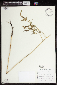 Amaranthus tuberculatus (Moquin-Tandon) J.D. Sauer 463923[1343722]Lehtinen, R. 95-20541995-09-08 United States, Minnesota, Lyon, Lyon Co, T113N R40W SE1/4 of the NE1/4 of S22;;113N;40W;22, 44.579613 -95.654909 |
MIN:Plants | Amaranthus tuberculatus (Moquin-Tandon) J.D. Sauer 706838[]Peterson, Jon 101979-10-06 United States, Minnesota, Houston, Houston County ... T 103 N, R 5 W, NW 1/4 NE 1/4 Sect. 2. About 3 miles west of Hokah, on U.S. 16;Dorer Memorial Hardwood State Forest;103N;05W;02, 43.75334 -91.402598 |
MIN:Plants | Amaranthus tuberculatus (Moquin-Tandon) J.D. Sauer 383499[]Moore, John; et al. 161601943-10-03 United States, Minnesota, Winona, Winona County...Near Hwy. 61, 1 mi. N of Minnesota City.;;;;, 44.108336 -91.749596 |
MIN:Plants | Amaranthus tuberculatus (Moquin-Tandon) J.D. Sauer 441181[]Schik, K. 95-1551995-08-29 United States, Minnesota, Yellow Medicine, Upper Sioux Agency State Park. Yellow Medicine Co. T115N R38W SE1/4 of the NW1/4 of S28...at Upper Sioux Agency State Park. Wetland is 100 m from the Minnesota River. 115N 38W 28, 44.735558 -95.43358 |
MIN:Plants | 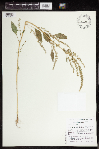 Amaranthus tuberculatus (Moquin-Tandon) J.D. Sauer 467238[1343732]Husveth, J. 95-17171995-09-04 United States, Minnesota, Goodhue, Goodhue Co. T113N R15W SE1/4 of the NE1/4 of S19; along Cannon River, recently cleared for highway construction.;Dorer Memorial Hardwood State Forest;113N;15W;19, 44.579109 -92.662048 |
MIN:Plants | 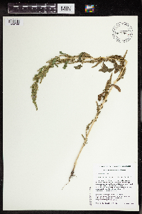 Amaranthus tuberculatus (Moquin-Tandon) J.D. Sauer 467394[1343733]Schik, K. 96-1701996-09-09 United States, Minnesota, Brown, Brown Co. T110N R31W SE1/4 of the NW1/4 of S3; Floodplain forest of the Minnesota River;;110N;31W;3, 44.360707 -94.543113 |
MIN:Plants | Amaranthus tuberculatus (Moquin-Tandon) J.D. Sauer 475948[]Smith, Welby 210591992-07-20 United States, Minnesota, Redwood, Cedar Rock Wildlife Management Area. Redwood County ... In Cedar Rock State Wildlife Management Area, about 4 miles north-northwest of Redwood Falls ... T 113N R 36W NW1/4 of NW1/4 of Sec 11. 113N 36W 11, 44.6122208 -95.1563873 |
MIN:Plants | Amaranthus tuberculatus (Moquin-Tandon) J.D. Sauer 484596[]Wheeler, Gerald 178751997-09-20 United States, Minnesota, Chippewa, Chippewa County...Ca. 4 mi. W of Milan...along NE shore of Lac Qui Parle Lake...W1/2 SE1/4 Sec. 13 T119N R43W;Lac Qui Parle Wildlife Management Area;119N;43W;13, 45.110235 -95.996766 |
MIN:Plants | Amaranthus tuberculatus (Moquin-Tandon) J.D. Sauer 488526[]Moore, John; Huff, N. 198061947-09-18 United States, Minnesota, Cottonwood, Along the shore of Talcott Lake.;;N;;, 43.878056 -95.452778 |
MIN:Plants | Amaranthus tuberculatus (Moquin-Tandon) J.D. Sauer 507378[]Moore, John 209251950-09-27 United States, Minnesota, Pipestone, Pipestone Co.; Along the Rock River, 1 mi. south of Edgerton.;;105N;44W;, 43.892202 -96.124459 |
MIN:Plants | Amaranthus tuberculatus (Moquin-Tandon) J.D. Sauer 507386[]Moore, John 209591950-09-29 United States, Minnesota, Watonwan, St. James Lake at St. James.;;106N;32W;, 43.978724 -94.679221 |
MIN:Plants |  Amaranthus tuberculatus (Moquin-Tandon) J.D. Sauer 507414[]Moore, John 209091950-09-27 United States, Minnesota, Rock, Along Beaver Creek at Manley.;;N;;, 43.592731 -96.429419 |
MIN:Plants |  Amaranthus tuberculatus (Moquin-Tandon) J.D. Sauer 519590[1343724]Smith, Welby 210591992-07-20 United States, Minnesota, Redwood, Cedar Rock Wildlife Management Area. Redwood County ... in Cedar Rock State Wildlife Management Area, about 4 mi north-northwest of Redwood Falls ... T113 R36W NW1/4 of NW1/4 of SEc 11. 113N 36W 11, 44.6122208 -95.1563873 |
MIN:Plants | Amaranthus tuberculatus (Moquin-Tandon) J.D. Sauer 550213[]Moore, John; et al. 222801954-09-22 United States, Minnesota, Lincoln, Lincoln County...On an island at the NE end of Lake Benton.;;110N;45W;25, 44.306759 -96.210724 |
MIN:Plants | Amaranthus tuberculatus (Moquin-Tandon) J.D. Sauer 568905[]Moore, John 253051960-09-28 United States, Minnesota, Blue Earth, 1 mi. E of Goodthunder.;;N;;, 44.004722 -94.065833 |
MIN:Plants | Amaranthus tuberculatus (Moquin-Tandon) J.D. Sauer 572494[]Moore, John; et al. 257691961-08-17 United States, Minnesota, Martin, Martin County...Trimont Prairie. SE1/4 Sec. 9, T103N, R32W.;;103N;32W;09, 43.739872 -94.684695 |
MIN:Plants | Amaranthus tuberculatus (Moquin-Tandon) J.D. Sauer 573927[]Stevens, O. 25241961-08-23 United States, Minnesota, Clay, Moorhead.;;139N;48W;, 46.845648 -96.728846 |
MIN:Plants | Amaranthus tuberculatus (Moquin-Tandon) J.D. Sauer 573942[]Stevens, O. 25231961-08-23 United States, Minnesota, Clay, Moorhead.;;139N;48W;, 46.845648 -96.728846 |
MIN:Plants | Amaranthus tuberculatus (Moquin-Tandon) J.D. Sauer 585624[]Moore, John 262391962-10-19 United States, Minnesota, Blue Earth, 1 mi. N of Mankato.;;N;;, 44.178061 -93.9994 |
MIN:Plants | Amaranthus tuberculatus (Moquin-Tandon) J.D. Sauer 585922[]Stevens, O. 26831963-09-05 United States, Minnesota, Clay, Buffalo River State Park.;Buffalo River State Park;139N;46W;10, 46.869327 -96.473428 |
MIN:Plants | Amaranthus tuberculatus (Moquin-Tandon) J.D. Sauer 585946[]Stevens, O. 26831963-09-05 United States, Minnesota, Clay, Buffalo River State Park.;Buffalo River State Park;139N;46W;10, 46.869327 -96.473428 |
MIN:Plants | Amaranthus tuberculatus (Moquin-Tandon) J.D. Sauer 602225[]Westkaemper, Remberta s.n.1966-07-00 United States, Minnesota, Stearns, Stearns Co. Lake Koronis, Paynesville.;;122N;32W;, 45.369206 -94.701702 |
MIN:Plants | Amaranthus tuberculatus (Moquin-Tandon) J.D. Sauer 657126[]Scanlan, M. 2501973-09-12 United States, Minnesota, Big Stone, BI-282 (Sec. 31, T122N, R45W). Just N of Long Tom Lake Proper.;;122N;45W;31, 45.333651 -96.356446 |
MIN:Plants | Amaranthus tuberculatus (Moquin-Tandon) J.D. Sauer 670739[]Heitlinger, M. 6141972-07-18 United States, Minnesota, McLeod, Schaefer Prairie: SE1/4 of Sec. 34, T115N, R29W. (TNC). Along drainage ditch leading into Buffalo Creek.;Schaefer Prairie, The Nature Conservancy;115N;29W;34, 44.72505 -94.30491 |
MIN:Plants | Amaranthus tuberculatus (Moquin-Tandon) J.D. Sauer 695791[]Clemants, Steven 9161977-09-17 United States, Minnesota, Crow Wing, Crosslake, W shore. T137N, R27W, NW1/4 Sec. 30.;;137N;27W;30, 46.653138 -94.145909 |
MIN:Plants | Amaranthus tuberculatus (Moquin-Tandon) J.D. Sauer 708344[]Ownbey, Gerald 6495-11979-09-16 United States, Minnesota, Freeborn, Albert Lea.;;N;;, 43.648013 -93.368266 |
MIN:Plants | Amaranthus tuberculatus (Moquin-Tandon) J.D. Sauer 708348[]Ownbey, Gerald 6495-61979-09-16 United States, Minnesota, Freeborn, Albert Lea.;;N;;, 43.648013 -93.368266 |
Google Map
Google Maps is a web mapping service provided by Google that features a map that users can pan (by dragging the mouse) and zoom (by using the mouse wheel). Collection points are displayed as colored markers that when clicked on, displays the full information for that collection. When multiple species are queried (separated by semi-colons), different colored markers denote each individual species.