University of Minnesota
http://www.umn.edu/
612-625-5000
http://www.umn.edu/
612-625-5000
Minnesota Biodiversity Atlas
Bell Museum
Dataset: MIN-Plants
Taxa: Astragalus
Search Criteria: excluding cultivated/captive occurrences
Bell Museum plants | |
 MIN:Plants | 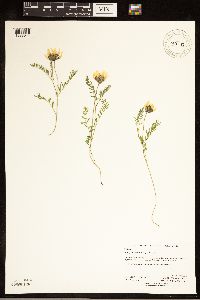 Astragalus agrestis Douglas ex G. Don 397747[1283044]Anderson, Derek S. 24152013-06-20 United States, Minnesota, Mahnomen, Wambach Wildlife Management Area, approximately 6.5 kilometers southeast of Bejou, T145N R41W SE 1/4 of SE 1/4 Sec. 06, 47.399569 -95.912665 |
MIN:Plants | 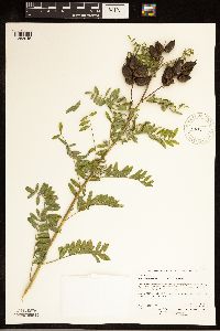 Astragalus neglectus (Torrey & A. Gray) E. Sheldon 409514[1283045]Anderson, Derek S. 23512014-08-28 United States, Minnesota, Mahnomen, Loncrace Wildlife Management Area, approximately 3km east of Bejou on County Road 1, then north on County Road 134 about 100 meters, T146N R42W SE 1/4 of SE 1/4 Sec. 24, 47.442627 -95.934618 |
MIN:Plants | 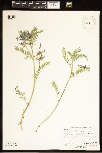 39131[1283049]Anderson, Derek S. 22702014-06-12 United States, Minnesota, Clay, Hatchet Lake Wildlife Protection Area, approximately 11km west of Hitterdal. 11km west of MN Highway 32 on County Road 26. T140N R45W NE 1/4 Sec. 06, 46.973054 -96.408732 |
MIN:Plants | 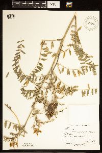 850696[1283050]Anderson, Derek S. 13422009-08-13 United States, Minnesota, Steele, Located 1.5km north of Medford on County Road 45. In the right-of-way. T108N R20W SE 1/4 of SE 1/4 Sec. 05, 44.185989 -93.248835 |
MIN:Plants | 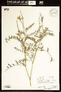 345874[1283051]Anderson, Derek S. 14382010-08-18 United States, Minnesota, Waseca, Located 5km east of Janesville on US Highway 14. In the right-of-way/, 44.110581 -93.64467 |
MIN:Plants | 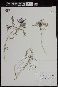 Astragalus agrestis Douglas ex G. Don 952903[1294939]Anderson, Derek S. 24512015-05-27 United States, Minnesota, Swift, 45.4 -95.7 |
MIN:Plants | 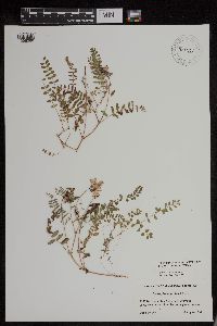 956212[1296066]Lawrence, D. B. s.n.1952-08-18 United States, Alaska, Glacier Bay National Monument. Camp Muir. [Glacier Bay National Park], 58.797428 -136.838127 |
MIN:Plants | 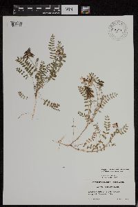 956211[1296065]Lawrence, D. B. s.n.1952-08-18 United States, Alaska, Glacier Bay National Monument. Camp Muir. [Glacier Bay National Park], 58.797428 -136.838127 |
MIN:Plants | 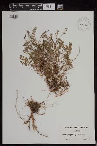 956202[1296046]Lawrence, D. B. s.n.1949-08-15 United States, Alaska, Glacier Bay National Monument. Station 49-3. [Glacier Bay National Park], 58.797428 -136.838127 |
MIN:Plants | 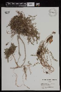 956292[1296006]Schoenike, R. 55-1171955-08-16 United States, Alaska, Glacier Bay National Monument. Cooper Station 26 [Glacier Bay National Park], 58.797428 -136.838127, 15m |
MIN:Plants |  955024[1295662]Kramer, Leona s.n.1927-00-00 United States, Minnesota, Mower, [no further data], 43.67147 -92.752514 |
MIN:Plants |  955025[1295661]Kaliher, Earl L. s.n.1927-00-00 United States, Minnesota, Todd, [no further data], 46.070624 -94.897599 |
MIN:Plants | 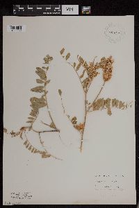 955026[1295660]Marsh, Lucian 851935-00-00 United States, Minnesota, Cass, [no further data], 46.887089 -94.095581 |
MIN:Plants | 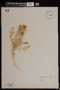 955080[1295859]Lampen, D. United States, Yellowstone National Park, 44.426573 -110.467041 |
MIN:Plants | 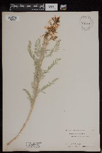 Astragalus drummondii Douglas ex Hook. 955078[1295860]Stork, H.E. United States, Yellowstone National Park, 44.426573 -110.467041 |
MIN:Plants | 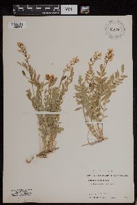 Astragalus miser var. hylophilus (Rydb.) Barneby 955079[1295861]Stork, H.E. 81 United States, Yellowstone National Park, 44.426573 -110.467041 |
MIN:Plants | 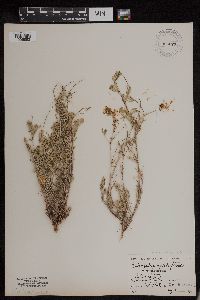 Astragalus vexilliflexus Sheldon 955077[1295862]Stork, H.E. 3252 United States, Montana, Yellowstone National Park |
MIN:Plants |  955116[1295848]anonymous 159 United States, Colorado, Montezuma |
MIN:Plants |  Astragalus speirocarpus A. Gray 955113[1296476]Eyerdam, Walter J. s.n.1938-05-22 United States, Washington, Yakima |
MIN:Plants |  Astragalus scopulorum Porter 955114[1296477]Anonymous 551944-06-27 United States, Colorado, [Mesa Verde National Park] |
MIN:Plants |  Astragalus racemosus Pursh 955115[1296478]Jenkins, F. E. s.n.1895-00-00 United States, Texas, El Paso, [No further data] |
MIN:Plants | 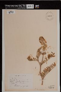 955120[1296479]Jenkins, F. E. s.n.1894-07-20 United States, Illinois, Montgomery |
MIN:Plants | 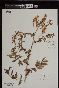 955119[1296480]Rogge, Janet 201954-07-05 United States, South Dakota, Minnehaha |
MIN:Plants | 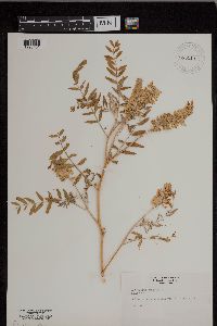 955118[1296481]Rogge, Janet 201954-07-18 United States, South Dakota, Minnehaha |
MIN:Plants | 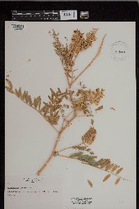 955117[1296482]Rogge, Janet 201954-07-18 United States, South Dakota, Minnehaha |
MIN:Plants |  955122[1296483]Rogge, Janet 201954-08-03 United States, South Dakota, Minnehaha |
MIN:Plants |  955121[1296484]Rogge, Janet 201954-07-05 United States, South Dakota, Minnehaha |
MIN:Plants |  Astragalus asper Jacq/ 955123[1296485]Khek s.n.1902-08-06 Austria |
MIN:Plants |  955124[1296486]Fernstrom, Margaret Dixon 61241900-06-12 Switzerland, [No further data] |
MIN:Plants | 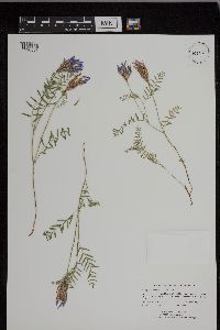 Astragalus agrestis Douglas ex G. Don 939319[1296557]Ruby, Janeen R. 1023 United States, Minnesota, Chippewa |
MIN:Plants | 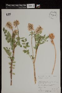 713328[1299107]Neese, Elizabeth 5066 United States, Utah, Garfield |
MIN:Plants | 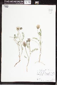 Astragalus agrestis Douglas ex G. Don 960961[1334044]Anderson, Derek S. 25432016-05-18 United States, Minnesota, Stevens, Verlyn Marth Memorial Prairie SNA, About 4 km northeast of Donnelly. Just east of the intersection of County Road 9 and County Road 76., 45.75 -96 |
MIN:Plants | 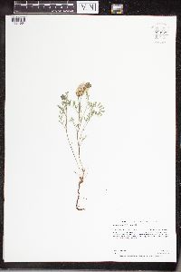 Astragalus agrestis Douglas ex G. Don 960971[1334054]Anderson, Derek S. 25402016-05-18 United States, Minnesota, Swift, Hamann WPA, About 18.5 km west-northwest of Benson. About 6 km east of U.S. Hwy 59 on 40th St. NW., 45.35 -95.83 |
MIN:Plants | 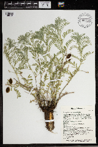 Astragalus crassicarpus Nuttall 966286[1359125]T. J. S. Whitfeld 25132020-06-03 United States, Minnesota, Washington, Lost Valley Prairie Scientific and Natural Area, 2 miles east north east of intersection of State Highway 95 and 110th Street, at dead-end of Nyberg Avenue South., 44.798227 -92.825035, 279m |
MIN:Plants | 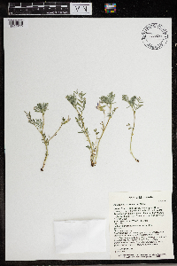 Astragalus crassicarpus Nuttall 966098[1356859]T. J. S. Whitfeld 25302020-06-03 United States, Minnesota, Washington, Lost Valley Prairie Scientific and Natural Area, 2 miles east north east of intersection of State Highway 95 and 110th Street, at dead-end of Nyberg Avenue South., 44.798286 -92.826338, 279m |
MIN:Plants | 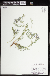 Astragalus crassicarpus Nuttall 963831[1352730]Welby R Smith 354352016-05-04 United States, Minnesota, Rice, Rice County Wilderness Park. On the east side of the Cannon River, about 11 km (6.8 miles) northeast of the approximate center of Faribault. NE of NE of section, 44.3824667 -93.2019667 |
MIN:Plants | 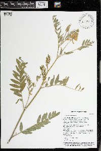 976543[1402133]Timothy J. S. Whitfeld 28982021-07-15 United States, Minnesota, St. Louis, Voyageurs National Park, 0.4 miles east of O’Leary Lake, 1/10th mile south of Hammer Bay, 48.415609 -92.520687, 352m |
MIN:Plants | 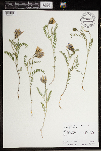 Astragalus agrestis Douglas ex G. Don 966766[1359551]Anderson, Derek S. 26932017-06-02 United States, Minnesota, Polk, Malmberg Prairie SNA. About 9 km south of Fisher, about 3.2 km south of the intersection of County Road 9 and County Road 56., 47.73 -96.82 |
MIN:Plants | 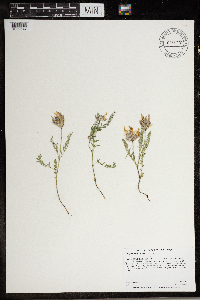 Astragalus agrestis Douglas ex G. Don 966770[1359547]Anderson, Derek S. 26972017-06-02 United States, Minnesota, Polk, Thorson Prairie WMA. About 7.5 km southeast of Harold. About 2.5-3 km east of State Highway 102 on County Road 247., 47.67 -96.41 |
MIN:Plants | 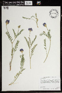 966852[1359465]Anderson, Derek S. 28702019-06-24 United States, Minnesota, Clay, Blanket Flower Prairie SNA. About 6 km south-southeast of Rollag. 600m southeast of the intersection of 280th St. S and 135th Ave. S., 46.69 -96.21 |
MIN:Plants | 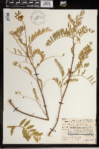 967631[1368217]Drew, L.A. s.n.1969-07-23 United States, Minnesota, Clay, 3.5 miles E Glyndon; T139N R46W sec. 16 SE NE 1/4, 46.853322 -96.487211 |
MIN:Plants | 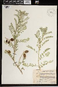 Astragalus crassicarpus Nuttall 967630[1368218]Drew, L.A. s.n.1969-07-02 United States, Minnesota, Mahnomen, 8 miles E Mahnomen; T144N R40W sec. 5 NW NW 1/4, 47.322621 -95.781917 |
MIN:Plants |  Astragalus drummondii Douglas ex Hook. 0967933[1368508]Nalani McCutcheon s.n.1987-00-00 United States, Wyoming, Gallatin Ranch |
MIN:Plants | 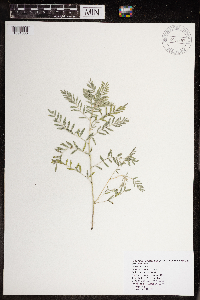 Astragalus flexuosus (Hooker) Douglas ex G. Don 968497[1391080]Johnson, Rhett A. 180042018-06-07 United States, Minnesota, Big stone, T 121N R45W sec. 6 SE 1/4 SE 1/4, 45.314167 -96.346111 |
MIN:Plants |  134187[1369319]Samaritani s.n.1897-03-00 Egypt, Prope Alexandrian Aegypti |
MIN:Plants | 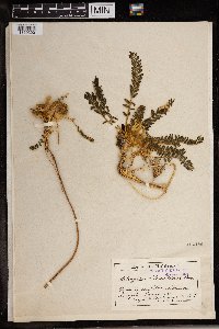 134186[1369320]J.B. Samaritani s.n.1857-01-00 Egypt, in ardis ver Alexandriam |
MIN:Plants | 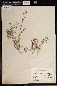 Astragalus annularis Forssk. 134268[1369321]J.D. Samaritani s.n.1857-02-00 Egypt |
MIN:Plants | 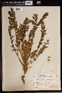 134442[1369322]A. Warion s.n.1896-04-10 Algeria |
MIN:Plants | 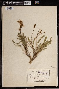 134583[1369323]E.G. Paris s.n.1867-03-14 Algeria |
MIN:Plants |  134881[1369324]J. B. Samaritani s.n.1896-03-00 Egypt, near Alexandria |
MIN:Plants |  134923[1369325]Heldreich s.n.1883-04-28 Algeria, Ozau |
MIN:Plants |  135095[1369326]O. Clari s.n.1888-04-19 Algeria, Sidi Bou Lefa |
MIN:Plants |  135171[1369327]J.D. Samaritani s.n.1856-04-00 Egypt, near Alexandria |
MIN:Plants |  135428[1369328]Debeaux s.n.1882-05-00 Algeria |
MIN:Plants |  135582[1369329]J. Samaritani s.n.1857-03-00 Egypt, prope Alexandrinm |
MIN:Plants |  135751[1369330]J.B. Samaritani s.n.1858-03-00 Egypt, Prope Alexandriam |
MIN:Plants |  973701[1397256]Bezanson, Char A. 1881991-07-17 United States, Minnesota, Rice, Railroad right-of-way on the southwestern edge of Faribault., 44.276586 -93.295821 |
MIN:Plants | []Timothy J. S. Whitfeld 37152023-07-07 United States, Minnesota, Marshall, Huntley Management Area, 0.5 miles northwest of right angle turn of 130th Avenue NE, 48.45447 -96.19626, 354m |
MIN:Plants | Astragalus caryocarpus Ker Gawl. []J. C. B. Waddington 601966-05-21 United States, Minnesota, Scott, 4.5 mi SW of Shakopee. T115N, R23W, Sect. 21, 44.754648 -93.59211 |
MIN:Plants | Astragalus crassicarpus Nuttall []Kerstin Griffin 521964-05-29 United States, Minnesota, Scott, 4 miles southwest Shakopee along Highway 169. Old pasture. Found in patches on slope, 44.757043 -93.584623 |
MIN:Plants | Astragalus caryocarpus Ker Gawl. []J. C. B. Waddington 601966-05-21 United States, Minnesota, Scott, 4.5 mi SW of SHakopee. T115N R23W Sect.21, 44.754648 -93.59211 |
MIN:Plants | 135426[]Aven Nelson 10881911-07-15 United States, Idaho, Elmore, King Hill |
MIN:Plants | 135302[]Thomas Howell 1885-05-14 United States, Oregon, Wheeler |
MIN:Plants | Astragalus marcidus Greene ex Rydb. []S. M. Tracy 3191902-04-28 United States, Texas, Davis Mountains |
MIN:Plants | 135261[]Ernest P. Walker 1791912-06-24 United States, Colorado, Montrose |
MIN:Plants | Astragalus owyheensis A.Nelson & J.F.Macbr. 135504[]Aven Nelson 18871912-07-02 United States, Idaho, Owyhee, Hot Hole, East Fork Bruneau |
MIN:Plants | Astragalus hosackiae Greene 135010[]Henry H. Rusby 1883-08-00 United States, Arizona, Coconino |
MIN:Plants | 491957[]C. L. Porter 53131950-06-03 United States, Utah, Uintah, On the Wasatch formation 5 miles south of Vernal, 1585m |
MIN:Plants | 134906[]E. L. Greene 1881-04-28 United States, Arizona, Gila Canon |
MIN:Plants | 134108[]A. W. E. Ehner 37591902-05-00 United States, California, Santa Barbara, Gaviota |
MIN:Plants | Astragalus earlei Greene ex Rydb. 134784[]S. M. Tracy 2261902-04-25 United States, Texas, Limpia Canon |
MIN:Plants | 134694[]S. M. Tracy 3291902-04-28 United States, Texas, Davis Mountains |
MIN:Plants | 266928[]Marcus E. Jones A. M. 1897-05-27 Unites States, Nevada, Hawthorne, Big Indian Canon, 1524m |
MIN:Plants | 134401[]J. Francis Macbride 2571910-06-13 United States, Idaho, Ada |
MIN:Plants | 134400[]J. Francis Macbride 1121910-05-26 United States, Idaho, Canyon |
MIN:Plants | Astragalus blakei Eggl. 254877[]W. W. E. 19491896-05-31 United States, Vermont, Willoughby Mt, Mt. Mansfield |
MIN:Plants | Astragalus blakei Eggl. 430894[]W. W. E. 1896-05-31 United States, Vermont, Rutland |
MIN:Plants | Astragalus blakei Eggl. 430895[]W. W. Eggleston 1896-05-31 United States, Vermont, Willoughby Mt. |
MIN:Plants | 134303[]A. A. Heller 32591896-06-19 United States, Idaho, Nez Perces, Lake Waha, 610 - 1067m |
MIN:Plants | 224387[]Alida P. Lansing 1891-00-00 United States, Colorado, Pueblo |
MIN:Plants | 134246[]Wm. C. Cusick 25831901-06-18 United States, Oregon, Desert of Alvord Valley |
MIN:Plants | 134140[]J. Francis Macbride 2601910-06-18 United States, Idaho, Ada |
Google Map
Google Maps is a web mapping service provided by Google that features a map that users can pan (by dragging the mouse) and zoom (by using the mouse wheel). Collection points are displayed as colored markers that when clicked on, displays the full information for that collection. When multiple species are queried (separated by semi-colons), different colored markers denote each individual species.