University of Minnesota
http://www.umn.edu/
612-625-5000
http://www.umn.edu/
612-625-5000
Minnesota Biodiversity Atlas
Bell Museum
Dataset: MIN-Plants
Taxa: Astragalus
Search Criteria: excluding cultivated/captive occurrences
Bell Museum plants | |
 MIN:Plants |  Astragalus neglectus (Torrey & A. Gray) E. Sheldon 444515[1075507]Sather, Nancy 94751994-08-25 United States, Minnesota, Mahnomen, White Earth Indian Reservation. Mahnomen County...White Earth Reservation...at interface of roadside ditch and MCT prairie. North side of road; T 144N R 40W NW1/4 of NW1/4 of Sec 5. 144N 40W 5, 47.3213882 -95.7836075 |
MIN:Plants |  Astragalus neglectus (Torrey & A. Gray) E. Sheldon 444523[1075505]Sather, Nancy 94891994-08-31 United States, Minnesota, Mahnomen, White Earth Indian Reservation. Mahnomen County...White Earth Reservation; at base of power pole in right of way on south side of county 107, just west of Sandhill River crossing. East of crest of hill...T 146N R 42W NE1/4 of NE1/4 of sec 5. 146N 42W 5, 47.4991684 -96.0222244 |
MIN:Plants |  Astragalus neglectus (Torrey & A. Gray) E. Sheldon 444524[1075496]Sather, Nancy 94461994-08-18 United States, Minnesota, Mahnomen, White Earth Indian Reservation. Mahnomen County...White Earth Reservation...North of public access road back from lake, not immediately adjacent to lake...T 144N R 40W SW1/4 of NW1/4 of Sec 7. 144N 40W 7, 47.3038902 -95.8005524 |
MIN:Plants |  Astragalus neglectus (Torrey & A. Gray) E. Sheldon 444553[1075497]Sather, Nancy 94901994-08-31 United States, Minnesota, Mahnomen, White Earth Indian Reservation. Mahnomen County...In right of way along both sides of road along Polk-Mahnomen Co line just east of rail crossing, west of Hwy 59...T 146N R 42W NW1/4 of NE1/4 of sec 3. 146N 42W 3, 47.4988899 -95.9813919 |
MIN:Plants | 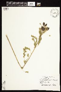 Astragalus neglectus (Torrey & A. Gray) E. Sheldon 444580[1075501]Sather, Nancy 94801994-08-29 United States, Minnesota, Mahnomen, Mahnomen County...Circle Lake WPA, White Earth Reservation...T 145N R 40W SW1/4 of NW1/4 of Sec 19;Circle Lake Wildlife Management Area / White Earth Indian Reservation;145N;40W;19, 47.3633347 -95.8013916 |
MIN:Plants | 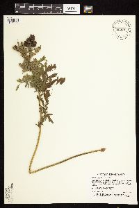 Astragalus neglectus (Torrey & A. Gray) E. Sheldon 444581[1075504]Sather, Nancy 94521994-08-23 United States, Minnesota, Polk, Polk County...right of way of north-south gravel road, between field and road...0.4 mile south of intersection... T147N R42W SE1/4 of NE1/4 of sec 4. 147N 42W 4, 47.5813904 -96.0027771 |
MIN:Plants | 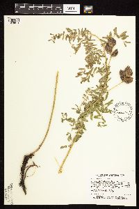 Astragalus neglectus (Torrey & A. Gray) E. Sheldon 444582[1075514]Sather, Nancy 94421994-08-10 United States, Minnesota, Mahnomen, Mahnomen County...Bejou WMA White Earth Reservation...at east end of WMA...T 146N R 42W SW1/4 of NW1/4 of Sec 28;Bejou Wildlife Management Area / White Earth Indian Reservation;146N;42W;28, 47.434029 -96.008286 |
MIN:Plants | 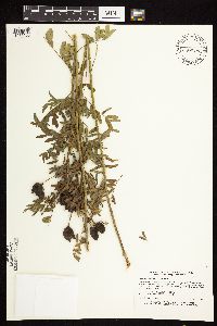 Astragalus neglectus (Torrey & A. Gray) E. Sheldon 444585[1075500]Sather, Nancy 94811994-08-30 United States, Minnesota, Polk, Polk County...county road 207 on east side of road about 100 meters south of large power pole... T 148N R 41W SW1/4 of NW1/4 of Sec 6. 148N 41W 6, 47.6658325 -95.9400024 |
MIN:Plants | 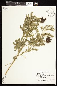 Astragalus neglectus (Torrey & A. Gray) E. Sheldon 444586[1075434]Sather, Nancy 94871994-08-31 United States, Minnesota, Polk, Polk County...Winger WPA...on north end of WPA...T 147N R 42W NE1/4 of NE1/4 of Sec 1;Winger Wildlife Area;147N;42W;01, 47.585556 -95.9419479 |
MIN:Plants | 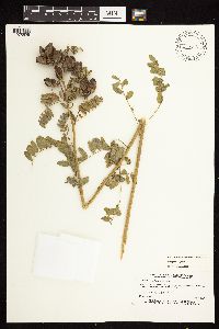 Astragalus neglectus (Torrey & A. Gray) E. Sheldon 445593[1075525]Sather, Nancy 218531995-07-01 United States, Minnesota, Mahnomen, Mahnomen Co.; Santee Prairie SNA; in extreme southeast corner of tract; T 145N R 41W SE1/4 of NE1/4 of Sec 7;Santee Prairie Scientific Natural Area / White Earth Indian Reservation;145N;41W;7, 47.3906158 -95.9224072 |
MIN:Plants | 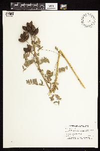 Astragalus neglectus (Torrey & A. Gray) E. Sheldon 445594[1075524]Sather, Nancy 218651995-08-16 United States, Minnesota, Mahnomen, White Earth Indian Reservation. Mahnomen County; North of Wild Rice river on east side of co. 3, right in the middle of the town of Beaulieu; T 145N R 4 Mahnomen County; North of Wild Rice river on east side of co. 3, right in the middle of the town of Beaulieu; T 145N R 40W SW1/4 of SW1/4 of Sec 30. 145N 40W 30, 47.3461592 -95.7948892 |
MIN:Plants | 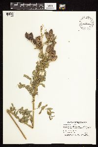 Astragalus neglectus (Torrey & A. Gray) E. Sheldon 445595[1075521]Sather-Knutsen, P. 950011995-08-19 United States, Minnesota, Mahnomen, White Earth Indian Reservation. Mahnomen Co.; One tenth mile west of Mahnomen county 3 on north side of Heier Township road; T 146N R 40W SE1/4 of SE1/4 Mahnomen Co.; One tenth mile west of Mahnomen county 3 on north side of Heier Township road; T 146N R 40W SE1/4 of SE1/4 of Sec 9. 146N 40W 9, 47.4768212 -95.7528373 |
MIN:Plants | 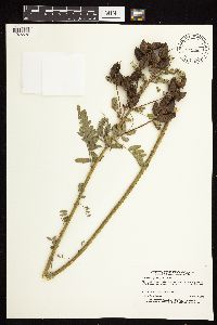 Astragalus neglectus (Torrey & A. Gray) E. Sheldon 445596[1075532]Sather-Knutsen, P. 950031995-08-19 United States, Minnesota, Polk, Polk Co.; Along south edge of Jenkins WOA, on slopes of right of way and into WPA; T 147N R 40W SE1/4 of SW1/4 of Sec 24;Jenkins Wildlife Management Area;147N;40W;24, 47.5355732 -95.6930951 |
MIN:Plants | 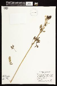 Astragalus neglectus (Torrey & A. Gray) E. Sheldon 457298[1075449]Sather, Nancy 94501994-08-23 United States, Minnesota, Polk, Polk County...on north side of county road 39 & 2...T 147N R 42W 10NE1/4 of Sec 15;;147N;42W;15, 47.5574989 -95.9866638 |
MIN:Plants | 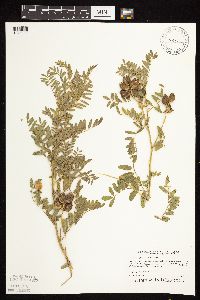 Astragalus neglectus (Torrey & A. Gray) E. Sheldon 458564[1075511]Puchalski, L. 3961993-08-12 United States, Minnesota, Mahnomen, Chief Lake Wildlife Management Area / White Earth Indian Reservation. Mahnomen Co.; Chief Lake WPA. On shore of unnamed lake on northern section of WPA; T 145N R 41W SW1/4 of NW1/4 of sec 14 Mahnomen Co.; Chief Lake WPA. On shore of unnamed lake on northern section of WPA; T 145N R 41W SW1/4 of NW1/4 of sec 14 [should this be sec.13?]. 145N 41W 14, 47.3753604 -95.8370347 |
MIN:Plants | 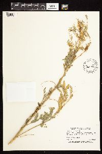 Astragalus neglectus (Torrey & A. Gray) E. Sheldon 460192[1075528]Sather, Nancy 218451995-08-12 United States, Minnesota, Mahnomen, White Earth Indian Reservation. Mahnomen Co.; On west side of Co. 113, just south of T junction where county road 12 meets 113; T 143N R 41W NE1/4 of Se Mahnomen Co.; On west side of Co. 113, just south of T junction where county road 12 meets 113; T 143N R 41W NE1/4 of Sec 12. 143N 41W 12, 47.215386 -95.8157621 |
MIN:Plants | 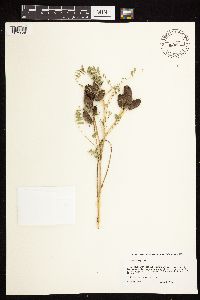 Astragalus neglectus (Torrey & A. Gray) E. Sheldon 460195[1075526]Tangemoen, P. s.n.1996-08-00 United States, Minnesota, Clearwater, White Earth Indian Reservation. Clearwater Co.; east side of snowmobile trail, 30 yards east of its crossing of solid bottom creek. This si about 200 ya Clearwater Co.; east side of snowmobile trail, 30 yards east of its crossing of solid bottom creek. This si about 200 yards north of state Highway 113. T143N R38W SWSWSW Sec 32. 143N 38W 32, 47.158731 -95.5191757 |
MIN:Plants | 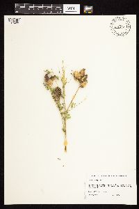 Astragalus neglectus (Torrey & A. Gray) E. Sheldon 460196[1075483]Tangemoen, P. s.n.1996-08-00 United States, Minnesota, Clearwater, Clearwater Co.; public access on east shore of Long Lost Lake; [and] north of launch area. In Long Lost Lake WMA.;Long Lost Lake Wildlife Management Area / White Earth Indian Reservation;143N;37W;18, 47.2019617 -95.413924 |
MIN:Plants | 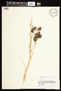 Astragalus neglectus (Torrey & A. Gray) E. Sheldon 460200[1075486]Frach, B. s.n.1996-08-19 United States, Minnesota, Beltrami, Beltrami Co.; Government lot 1 betwaeen Buzzle Creek and NW shore of Big Buzzle Lake. Reported by owner as being in Sect Beltrami Co.; Government lot 1 betwaeen Buzzle Creek and NW shore of Big Buzzle Lake. Reported by owner as being in Section 21, but county assessor's office say lot 1 owned by this source is in Section 20. T148N R35W NESE Sec 20. 148N 35W 20, 47.6226162 -95.1529685 |
MIN:Plants | 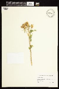 Astragalus neglectus (Torrey & A. Gray) E. Sheldon 460201[1075529]Jirik, D. s.n.1996-08-15 United States, Minnesota, Mahnomen, Mahnomen County...at southeast end of Paul Jr. WPA near west side of County Road 113. T143N R41W NE Sec 12;Paul Jr Wildlife Management Area / White Earth Indian Reservation;143N;41W;12, 47.215386 -95.8157621 |
MIN:Plants |  Astragalus neglectus (Torrey & A. Gray) E. Sheldon 460202[1075476]Espeseth, A.; Espeseth, J. s.n.1996-09-09 United States, Minnesota, Polk, Polk Co.; on the northwest side of the village of Winger. T147N R42W SWNE Sec 22;;147N;42W;22, 47.5353623 -95.9927278 |
MIN:Plants |  Astragalus neglectus (Torrey & A. Gray) E. Sheldon 460327[1075482]Sather, Nancy 94651994-07-25 United States, Minnesota, Mahnomen, White Earth Indian Reservation. Mahnomen County...White Earth Reservation along Twin Lake Creek, both north & south of county road 14. Under power line north of road...T 145 R 40W NE1/4 of Sec 12. 145N 40W 12, 47.396389 -95.6800003 |
MIN:Plants |  Astragalus neglectus (Torrey & A. Gray) E. Sheldon 463683[1075536]Sather, Nancy 94881994-08-31 United States, Minnesota, Polk, Polk County...In right of way along both sides of road along Polk-Mahnomen County line. Just east of rail crossing, west of Hwy 59...T 147N R 42W SE1/4 of Sec 34. 147N 42W 34, 47.5002785 -95.9813919 |
MIN:Plants |  Astragalus neglectus (Torrey & A. Gray) E. Sheldon 476438[1075487]Sather, Nancy s.n.1995-08-30 United States, Minnesota, Mahnomen, Mahnomen Co.; just northeast of St. Joseph's Church and road; T144 R40NENW of Sec. 7;White Earth Indian Reservation;144N;40W;7, 47.3023322 -95.7948863 |
MIN:Plants |  Astragalus neglectus (Torrey & A. Gray) E. Sheldon 514677[1075498]Dana, R. 930021993-07-15 United States, Minnesota, Marshall, Marshall County...along U.S. Hwy 59 0.75 mi SE of jct with Co. Rd. 28 in Newfolden...growing on hwy ... berm, E side of hwy...T 156N R 44W NW1/4 of SW1/4 of Sec 9. 156N 44W 9, 48.3466682 -96.319725 |
MIN:Plants |  Astragalus neglectus (Torrey & A. Gray) E. Sheldon 515243[1075433]Sather, Nancy 94681994-08-25 United States, Minnesota, Mahnomen, Mahnomen County...White Earth Reservation...T 145N R 40W NW1/4 of SW1/4 of sec 23;White Earth Indian Reservation;145N;40W;23, 47.3577766 -95.7191696 |
MIN:Plants |  Astragalus neglectus (Torrey & A. Gray) E. Sheldon 515246[1075436]Sather, Nancy 94491994-08-22 United States, Minnesota, Mahnomen, White Earth Indian Reservation. Mahnomen County...White Earth Reservation...on west side of road 100 in ditch near crest of the hill... T 143N R 41W NE1/4 of SE1/4 of Sec 27. 143N 41W 27, 47.1716652 -95.8477783 |
MIN:Plants |  Astragalus neglectus (Torrey & A. Gray) E. Sheldon 518584[1075444]Sather, Nancy 94831994-08-30 United States, Minnesota, Polk, Polk County...on E side of road at crest of hill, S of junction with westbound road that travels through center of section 18...T147N R39W NW1/4 of SW1/4 of Sec 17. 147N 39W 17, 47.5486107 -95.6611099 |
MIN:Plants | 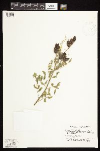 Astragalus neglectus (Torrey & A. Gray) E. Sheldon 518585[1075443]Sather, Nancy 94721994-08-25 United States, Minnesota, Mahnomen, Mahnomen County...White Earth Reservation... 0.2 miles S of intersection...T145N R40W NW1/4 of NW1/4 of sec.21;White Earth Indian Reservation;145N;40W;21, 47.3655548 -95.7627792 |
MIN:Plants | 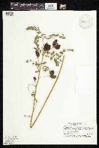 Astragalus neglectus (Torrey & A. Gray) E. Sheldon 518625[1075446]Sather, Nancy 94711994-08-25 United States, Minnesota, Mahnomen, White Earth Indian Reservation. Mahnomen County...White Earth Reservation; in right of way at NE corner of section, right of way is only about 1 meter wide...T145N R40W NE1/4 of NE1/4 of Sec 20. 145N 40W 20, 47.3672218 -95.7633362 |
MIN:Plants | 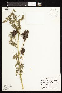 Astragalus neglectus (Torrey & A. Gray) E. Sheldon 518626[1075447]Sather, Nancy 94761994-08-25 United States, Minnesota, Mahnomen, White Earth Indian Reservation. Mahnomen County...White Earth Reservation...W of Simonson Lake and E of road; [also] in right of way on E side of road. as far as the driveway entrance to the house in sec.21...T 146N R 40W SE1/4 of NE1/4 of Sec 21. 146N 40W 21, 47.4536095 -95.7419434 |
MIN:Plants | 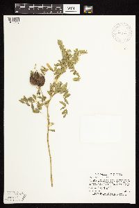 Astragalus neglectus (Torrey & A. Gray) E. Sheldon 518627[1075448]Sather, Nancy 94771944-08-25 United States, Minnesota, Mahnomen, Mahnomen County...White Earth Reservation...on E side of road...T146N R40W 22 SE1/4 of Sec 21;White Earth Indian Reservation;146N;40W;21, 47.4438896 -95.7425003 |
MIN:Plants |  Astragalus neglectus (Torrey & A. Gray) E. Sheldon 518643[1075445]Sather, Nancy 94691994-08-25 United States, Minnesota, Mahnomen, White Earth Indian Reservation. Mahnomen County...White Earth Reservation; on S side of road; between road and Twin Lake; also on S side of road E of creek. About 100 meters W of N-bound curve...T 145N R 40W NW1/4 of NE1/4 of Sec 34. 145N 40W 34, 47.3380547 -95.7286148 |
MIN:Plants |  Astragalus neglectus (Torrey & A. Gray) E. Sheldon 518805[1075537]Sather, Nancy 94511994-08-23 United States, Minnesota, Polk, Polk County...in right of way on north side of county road 39, 0.4 mile west of intersection with north-south road. Just east of field access turnout...T 147N R 42W SE1/4 of SW1/4 of Sec 10. 147N 42W 10, 47.5569458 -95.9955521 |
MIN:Plants |  Astragalus neglectus (Torrey & A. Gray) E. Sheldon 518896[1075435]Sather, Nancy 94411994-08-04 United States, Minnesota, Mahnomen, Dittmer Wildlife Management Area / White Earth Indian Reservation. Mahnomen County...Dittmer WMA White Earth Reservation...at N end of WMA near road and extending into right of way. Along ditch eastward...T145N R42W NW1/4 of NE1/4 of Sec 6. 145N 42W 6, 47.4119453 -96.0505524 |
MIN:Plants |  Astragalus neglectus (Torrey & A. Gray) E. Sheldon 518898[1075452]Sather, Nancy 94791994-08-25 United States, Minnesota, Mahnomen, Mahnomen County...White Earth Reservation; on east side of county 3...T 146N R 40W NW1/4 of NW1/4 of Sec 10;White Earth Indian Reservation;146N;40W;10, 47.4816666 -95.7419434 |
MIN:Plants |  Astragalus neglectus (Torrey & A. Gray) E. Sheldon 518899[1075442]Sather, Nancy 94531994-08-23 United States, Minnesota, Polk, Polk County...west of Bradley Lake between county road 34 & lake. In area where road comes closest to the lake... T 148N R 42W SW1/4 of NW1/4 of Sec 28. 148N 42W 28, 47.6105537 -96.0138855 |
MIN:Plants |  Astragalus neglectus (Torrey & A. Gray) E. Sheldon 518900[1075451]Sather, Nancy 94781994-08-25 United States, Minnesota, Mahnomen, White Earth Indian Reservation. Mahnomen County...White Earth Reservation; between recently burned oak/sumac knoll and road. West side of of road. About .4 mile south of intersection with eastbound road...T 146N R 40W SE1/4 of NE1/4 of Sec 28. 146N 40W 28, 47.435276 -95.7422256 |
MIN:Plants |  Astragalus neglectus (Torrey & A. Gray) E. Sheldon 518901[1075450]Sather, Nancy 94451994-08-13 United States, Minnesota, Mahnomen, Bejou Wildlife Management Area / White Earth Indian Reservation. Mahnomen County...Bejou WMA White Earth Reservation; along south side of county road 1, east of trail into west side of Bejou WMA...T 146N R 42W NE!/4 of NW1/4 of Sec 29. 146N 42W 29, 47.4416656 -96.0358353 |
MIN:Plants |  Astragalus neglectus (Torrey & A. Gray) E. Sheldon 519120[1075508]Puchalski, L. 4291993-08-24 United States, Minnesota, Mahnomen, Mahnomen Co.; on the E side of Edwin Lake WPA; W side of the county road; T145N R40W NE1/4 of SW1/4 of Sec 29;Edwin Lake Wildlife Management Area / White Earth Indian Reservation;145N;40W;29, 47.3461657 -95.774277 |
MIN:Plants |  Astragalus neglectus (Torrey & A. Gray) E. Sheldon 536172[1075472]Anderson, W. s.n.1947-08-04 United States, Minnesota, Becker, De Soto Lake, Itasca State Park;Itasca State Park;142N;36W;, 47.145723 -95.222736 |
MIN:Plants | 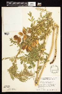 Astragalus neglectus (Torrey & A. Gray) E. Sheldon 561079[1075469]Ownbey, Gerald; Anderson, Henry 28511959-07-18 United States, Minnesota, Clearwater, N end of Morrison Lake; SE1/4 Sec. 33 T143N R36W;Itasca State Park;143N;36W;33, 47.1594552 -95.2441013 |
MIN:Plants | 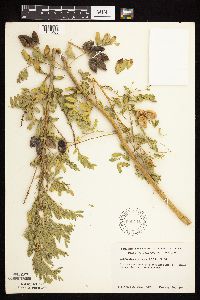 Astragalus neglectus (Torrey & A. Gray) E. Sheldon 590441[1075463]Ownbey, Gerald 38291965-08-18 United States, Minnesota, Polk, Polk County...3 mi NW of Lengby near rte 2, near roadway;;147N;40W;, 47.54911 -95.687051 |
MIN:Plants | 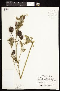 Astragalus neglectus (Torrey & A. Gray) E. Sheldon 744032[1075441]Sather, Nancy 94851994-08-30 United States, Minnesota, Polk, Polk County...Sollie Enterprises WPA...T 147N R 40W SW1/4 of NW1/4 of Sec 12;Sollie Wildlife Management Area;147N;40W;12, 47.5675011 -95.7019424 |
MIN:Plants | 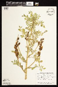 Astragalus neglectus (Torrey & A. Gray) E. Sheldon 758460[1075468]Smith, Welby 68021982-07-19 United States, Minnesota, Marshall, Ca. 2 mi SSW of Holt; NW1/4 SW1/4 Sec. 8 T155N R43W;;155N;43W;8, 48.2615553 -96.2061538 |
MIN:Plants |  Astragalus neglectus (Torrey & A. Gray) E. Sheldon 765012[1122618]Lugger, O. 71041900-08-00 United States, Minnesota, Otter Tail, Ottertail Co.;;;;, 46.408474 -95.719312 |
MIN:Plants |  Astragalus neglectus (Torrey & A. Gray) E. Sheldon 780459[1075478]Ownbey, Gerald 69381984-07-07 United States, Minnesota, Mahnomen, White Earth Indian Reservation. Mahnomen Co. N side of Minn. rt. 200, 7.9 mi W of its jnc with Clearwater Co. rt. 7 in Roy Lake; T145N R40W Sec. 35 SW1/ Mahnomen Co. N side of Minn. rt. 200, 7.9 mi W of its jnc with Clearwater Co. rt. 7 in Roy Lake; T145N R40W Sec. 35 SW1/4. 145N 40W 35, 47.3314314 -95.7104867 |
MIN:Plants |  Astragalus neglectus (Torrey & A. Gray) E. Sheldon 829993[1075480]Townsend, D. 91-1371991-07-10 United States, Minnesota, Marshall, Marshall Co. 3 mi S of Newfolden on E side of St. Hwy.59 in right of way; NE1/4 NW1/4 Sec 27 T156N R44W;;156N;44W;27, 48.3066889 -96.2922989 |
MIN:Plants |  Astragalus neglectus (Torrey & A. Gray) E. Sheldon 831741[1075512]Harris, Fred 920851992-07-27 United States, Minnesota, Pennington, Pennington Co.; NW1/4 NW1/4 Sec 9 T152N R44W;;152N;44W;9, 47.9992069 -96.2992633 |
MIN:Plants | 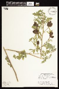 Astragalus neglectus (Torrey & A. Gray) E. Sheldon 840313[1075488]Dahle, R.; et al. 950171995-08-22 United States, Minnesota, Mahnomen, Mahnomen Co. Along co rd 13 about 2.2 mi N of 113; on the W side of the road; T143N R41W NE1/4 of SW1/4 of Sec 12.;White Earth Indian Reservation;143N;41W;12, 47.215386 -95.8157621 |
MIN:Plants | 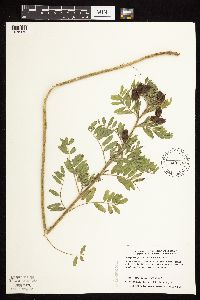 Astragalus neglectus (Torrey & A. Gray) E. Sheldon 840336[1075479]Dahle, R.; et al. 950161995-08-22 United States, Minnesota, Becker, White Earth Indian Reservation. Becker Co. 1 mi S of the county line and about 1.2 mi E of co road 111; on the N side of the road; T142N R41W SW1/4 of SW1/4 of Sec 2.. 142N 41W 2, 47.1288842 -95.8580465 |
MIN:Plants | 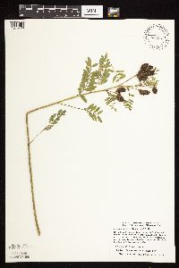 Astragalus neglectus (Torrey & A. Gray) E. Sheldon 840337[1075489]Dahle, R.; et al. 950151995-08-22 United States, Minnesota, Becker, White Earth Indian Reservation. Becker Co. 1 mi S of the county line and about 0.8 mi E of co road 111; S and N sides of the road. The plants on the N side wre in SESE of sec.3; T142N R41W NE1/4 of NE1/4 of Sec 10.. 142N 41W 10, 47.1288842 -95.8580465 |
MIN:Plants | 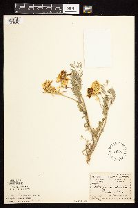 135661[1075540]Menzel, Max 17611895-05-00 United States, Minnesota, Pipestone, Pipestone [assuming the quarry area; town generally noted as Pipestone City by collector];Pipestone National Monument;106N;46W;01, 44.01585 -96.31767 |
MIN:Plants | 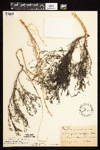 Astragalus tenellus Pursh 138065[1075541]Sheldon, Edmund S34291892-08-00 United States, Minnesota, Otter Tail, Eagle Lake, O.T. Co.;;131N;40W;10, 46.1728347 -95.6976807 |
MIN:Plants | 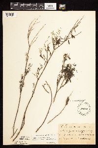 Astragalus tenellus Pursh 138066[1075543]Sheldon, Edmund S35351892-08-00 United States, Minnesota, Otter Tail, Lake Belmont;;;;, 46.198513 -95.641335 |
MIN:Plants | 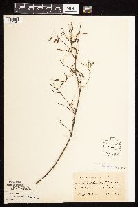 Astragalus tenellus Pursh 138067[1075542]Sheldon, Edmund s.n.1892-08-00 United States, Minnesota, Otter Tail, Lake Belmont;;N;;, 46.198513 -95.641335 |
MIN:Plants | 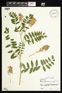 907801[1074852]Gerdes, Lynden 52022006-07-12 United States, Minnesota, Itasca, Chippewa National Forest. T58N R26W S11SENESE. Itasca County, MN. Chippewa National Forest. Bowstring State Forest. Approximately 6.58 miles SE of Marcell, MN and 0.58 mile NW of Fly Lake. Along NE side of FR 2373.. 058N 26W 11, 47.5230557 -93.6084496 |
MIN:Plants | 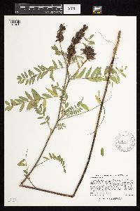 905744[1074941]Lee, Michael MDL41152005-08-25 United States, Minnesota, Becker, White Earth Indian Reservation / White Earth State Forest. Becker County...along State Hwy 113, ten miles northwest of Two Inlets...northern end of Bad Medicine Lake (Lake of the Valley)...slope below the edge of the Wayside Rest parking lot...T142N R37W SE1/4 of NW1/4 Sec. 4. 142N 37W 4, 47.1443308 -95.3715221 |
MIN:Plants | 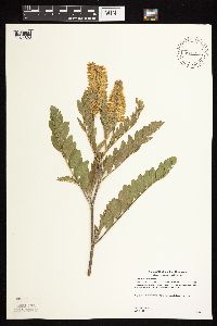 489198[1074893]Gerdes, Lynden 47812003-07-18 United States, Minnesota, Lake, Superior National Forest. T58N R09W S15SESE Lake County ... Superior National Forest. Approximately 8.99 miles SSW of Isabella, MN and 0.68 mile SE of Spruce Lake; south side of RR tracks.. 058N 09W 15, 47.5091309 -91.4584799 |
MIN:Plants | 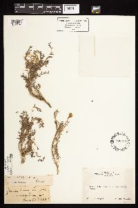 Astragalus bolanderi A. Gray 236033[1074849]Congdon, J. s.n.1885-06-30 United States, California, Mariposa, Glacier Pint Turnpike, Mariposa County;Yosemite National Park;;;, 37.82714 -119.53674 |
MIN:Plants | 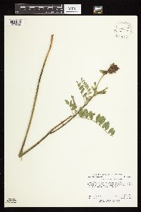 910152[1074992]Anderson, Derek 10252008-08-27 United States, Minnesota, Dodge, Dodge County...T106N, R16W, NWSW35...about 6 km northeast of Oslo;;106N;16W;35, 43.9408333 -92.7127778 |
MIN:Plants |  Astragalus adsurgens var. robustior von Pallas 478239[1074684]Lee, Michael MDL22211998-07-02 United States, Minnesota, Stearns, Stearns County ... On west side of County Road 10 one mile north of Roscoe ... T123N R32W S1/2 of NE1/4 of SE1/4 Sec. 24;;123N;32W;24, 45.4482855 -94.650389 |
MIN:Plants |  Astragalus lotiflorus Hooker 454287[1075293]Biederman, L. 1011999-05-12 United States, Minnesota, Big Stone, Big Stone County ... Big Stone Wildlife Refuge.;Big Stone National Wildlife Refuge;;;, 45.260976 -96.342597 |
MIN:Plants |  905588[1074894]Gerdes, Lynden 43022000-09-18 United States, Minnesota, Lake, Lake Superior overlook approx. .75 mile ESE of Nipisiquit Lake. SWNE of section;North Shore / Tettegouche State Park;056N;07W;09, 47.3506024 -91.229562 |
MIN:Plants |  914663[1075103]Smith, Welby 226321993-07-01 United States, Minnesota, Otter Tail, Inspiration Peak Scenic Wayside Park. Otter Tail County ... Inspiration Peak State Wayside Park, about 12 miles west of Parkers Prairie ... T131N R39W SE1/4 of SW1/4 of Sec 22. 131N 39W 22, 46.1383333 -95.5736111 |
MIN:Plants | 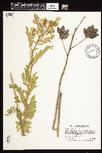 Astragalus neglectus (Torrey & A. Gray) E. Sheldon 914868[1075539]Smith, Welby 226921993-07-01 United States, Minnesota, Otter Tail, Maplewood State Park. Otter Tail County ... Maplewood State Park, about 5 miles east-southeast of Pelican Rapids ... West side of a gravel road just across from Andrews lake ... T135N R42W SE1/4 of NE1/4 of Sec 9. 135N 42W 9, 46.5225 -95.9727778 |
MIN:Plants | 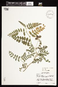 904323[1075050]Gerdes, Lynden 53022006-08-15 United States, Minnesota, Saint Louis, Superior National Forest. T60N R12W S11NESWSW St. Louis County ... Superior National Forest. Approximately 4.55 miles ESE of Babbitt ... and 0.04 miles N of FR # 424 (New Tomahawk Rd.). 060N 12W 11, 47.6948078 -91.829078 |
MIN:Plants | 478943[1075375]Wheeler, Gerald United States, Minnesota, Chippewa, Detailed locality information protected. This is typically done to protect rare or threatened species localities. |
MIN:Plants | 656988[1074845]Noble, Mark; et al. United States, Alaska, Detailed locality information protected. This is typically done to protect rare or threatened species localities. |
MIN:Plants | 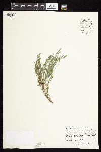 Astragalus lotiflorus Hooker 482626[1075363]Lee, Michael MDL21911998-06-27 United States, Minnesota, Pope, Ordway Prairie, The Nature Conservancy. Pope Co.: Catherine Ordway Nature Conservancy Preserve along State Hwy 104; southwest of Lake Johanna; T123N R36W SE1/4 of SW1/4 of NE1/4 Sec. 30. 123N 36W 30, 45.4342616 -95.2450181 |
MIN:Plants | 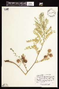 435075[1075060]Lee, Michael MDL21781998-06-25 United States, Minnesota, Stearns, Stearns County ... southwest of Big Lake 2-1/2 miles southeast of Roscoe ... T123N R31W SW1/4 of NE1/4 of SW1/4 Sec. 33;;123N;31W;33, 45.4196165 -94.5777644 |
MIN:Plants |  Astragalus utahensis Torrey & A. Gray 680264[1075544]Bright, R. 74-1591974-09-11 United States, Idaho, Franklin, Franklin Co, Mouth of Cub River, Gravel Pit north of road, 6 mi SE Preston., 1463m |
MIN:Plants | Astragalus NULL 475445[]Breckenridge, Walter 62-2051962-08-21 Canada, Northwest Territories, District of Mackenzie ... 5 miles south of the arctic coast; Tree River 60 miles E. of Coppermine;;;;, 67.75 -112.5 |
MIN:Plants |  Astragalus congdonii S. Watson 236197[1075056]Congdon, J. s.n.1883-03-00 United States, California, Mariposa, Hite's Cove, Mariposa County...Type locality;Yosemite National Park |
MIN:Plants |  489467[1075181]Bosch, T. 182001-05-25 United States, Minnesota, Big Stone, Approx. 0.5 mile east of Hwy. 75 and 2 miles south of Hwy. 7.;;120N;45W;01, 45.2324999 -96.2365357 |
MIN:Plants |  Astragalus lotiflorus Hooker 454286[1075296]Biederman, L. 0731999-05-04 United States, Minnesota, Yellow Medicine, Yellow Medicine County ... Antelope Hills South ... T116N R45 NW27 [prob means T115 otherwise in next county];;115N;45W;27, 44.7400273 -96.266909 |
MIN:Plants |  913138[1074993]Scott, P. 26462006-08-20 United States, Minnesota, Saint Louis, St. Louis Co. ...SNF. T65N R15W sec. 6 SENWNW.;Superior National Forest;065N;15W;06, 48.1423153 -92.3104845 |
MIN:Plants |  Astragalus agrestis Douglas ex G. Don 552976[1074754]Tester, John s.n.1958-05-31 United States, Minnesota, Mahnomen, 3-4 miles w. and 1 mile s. of Waubun. ;Waubun Prairie Wildlife Management Area / White Earth Indian Reservation;143N;42W;33, 47.1589041 -96.0074302 |
MIN:Plants |  492637[1074947]Bosch, T. 472001-07-01 United States, Minnesota, Big Stone, Approx. 0.5 mile east of Hwy.75 and 2 miles south of Hwy.7. Sec.1-2;;120N;45W;, 45.2324999 -96.2365357 |
MIN:Plants |  Astragalus lotiflorus Hooker 491247[1075288]Whitfeld, T.J.S. 4152003-06-11 United States, Minnesota, Douglas, Seven Sisters Prairie, The Nature Conservancy. Douglas County ...Seven Sisters Prairie; 3 miles north of Melby, north shore of Lake Christina; on the Douglas/Otter Tail County line ... T130N R40W NENW 5. 130N 40W 5, 46.1063881 -95.7422256 |
MIN:Plants |  Astragalus adsurgens var. robustior von Pallas 429008[1074691]Wheeler, Gerald 171471997-08-11 United States, Minnesota, Renville, Renville County ... Ca. 6 mi. SW of Sacred Heart ... SE1/4 SW1/4 NE1/4 Sec. 19 T115N R38W;;115N;38W;19, 44.7496446 -95.4748403 |
MIN:Plants |  Astragalus chandonnettii Lunell 254878[1000338]Chandonnet, Z. s.n.1911-06-16 United States, Minnesota, Becker, McHugh near Detroit [Lakes] in a railroad yard;;138N;40W;18, 46.7672463 -95.7849978 |
MIN:Plants |  499759[1074877]Wheeler, Gerald 164241997-06-30 United States, Minnesota, Chippewa, Chippewa County ... Ca. 3 mi. SE of Montevideo ... E1/2 NW1/4 Sec. 27 T117N R40W;;117N;40W;27, 44.9130395 -95.6656252 |
MIN:Plants |  917185[1074942]Gerdes, Lynden; et al. 53502006-09-13 United States, Minnesota, Itasca, T58N R25W S19NWSW. Itasca County, MN. Chippewa National Forest. Spider Lake, Approximately 8.96 miles SE of Marcell;Chippewa National Forest;058N;25W;19, 47.4939398 -93.56642 |
MIN:Plants | 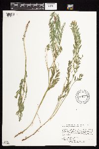 Astragalus adsurgens var. robustior von Pallas 898627[1074689]Lee, Michael; et al. MDL40792005-08-12 United States, Minnesota, Becker, Becker County...2.5 miles northeast of Ogema...T142N R41W E1/2 of SE1/4 of SE1/4 Sec. 5;White Earth Indian Reservation;142N;41W;05, 47.1437289 -95.9002214 |
MIN:Plants | 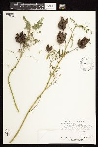 Astragalus neglectus (Torrey & A. Gray) E. Sheldon 913158[1075495]Rowe, Erika ERR20060830022006-08-30 United States, Minnesota, Becker, White Earth Indian Reservation. Becker County...Island/peninsula in the middle of the southern half of Big Sugar Bush Lake and adjacent to the WMA of the same name. 1.5 miles west of Hwy 34...slope on Big Sugar Bush Lake...SWSE S08 T141N R40W. 141N 40W 8, 47.0366667 -95.2719444 |
MIN:Plants | 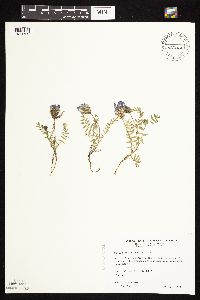 Astragalus agrestis Douglas ex G. Don 485062[1074752]Wheeler, Gerald 196991999-05-17 United States, Minnesota, Traverse, Traverse County ... Ca. 3 mi. SW of jct. of Tre(s). 27 and 117, SE of Tre. 27. On NW-facing bluff ... E1/2 NE1/4 etc.;;126N;48W;13, 45.7235437 -96.6461699 |
MIN:Plants | 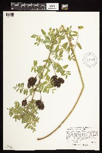 Astragalus neglectus (Torrey & A. Gray) E. Sheldon 904521[1075493]Lee, Michael MDL41142005-08-25 United States, Minnesota, Becker, White Earth Indian Reservation / White Earth State Forest. Becker County...along State Hwy 113, ten miles northwest of Two Inlets...northern end of Bad Medicine Lake (Lake of the Valley)...below the edge of the Wayside Rest parking lot...T142N R37W SE1/4 of NW1/4 Sec. 4. 142N 37W 4, 47.1443308 -95.3715221 |
MIN:Plants |  Astragalus elatiocarpus Sheldon 134788[1000344]Sheldon, Edmund S.38091892-08-00 United States, Minnesota, Otter Tail, Silver Lake;;137N;39W;07, 46.6940683 -95.6580664 |
MIN:Plants |  Astragalus lotiflorus Hooker 476113[1075365]Wheeler, Gerald 202801999-08-04 United States, Minnesota, Renville, Renville Co.; Ca. 1.4 mi. SE of Morton on Rte. 51, NNE of road; S1/2 NE1/4 NW1/4 Sec. 4 T112n R34W;;112N;34W;4, 44.5354016 -94.9368815 |
MIN:Plants |  480693[1075008]Juhnke, C. 3392001-07-31 United States, Minnesota, Goodhue, Goodhue County ... Frontenac State Park ... just south of road to the park shop ... T 112N R 13W SW NE NW 11;Frontenac State Park;112N;13W;11, 44.5199905 -92.3392244 |
MIN:Plants | 455752[1075373]Wheeler, Gerald United States, Minnesota, Traverse, Detailed locality information protected. This is typically done to protect rare or threatened species localities. |
MIN:Plants |  511355[1122631]Davis, Owen MN76-31976-00-00 United States, Minnesota, Pope, Pope Co.;;;;, 45.586015 -95.444479 |
MIN:Plants | 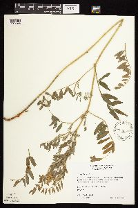 459967[1074988]Wheeler, Gerald 169871997-08-07 United States, Minnesota, Swift, Swift County ... Ca. 8 mi. N of Kerkhoven, at jct. of Rte. 35 and rte. 18 ... N1/2 NW1/3 Sec. 10 T121N R37W (Hayes 10);;121N;37W;10, 45.3037058 -95.3063695 |
MIN:Plants | 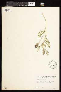 Astragalus agrestis Douglas ex G. Don 539886[1074753]Tester, John s.n.1957-06-22 United States, Minnesota, Mahnomen, 3-4 miles w. and 1 mile s. of Waubun. ;Waubun Prairie Wildlife Management Area / White Earth Indian Reservation;143N;42W;33, 47.1589041 -96.0074302 |
MIN:Plants | 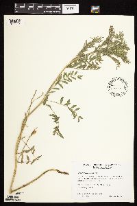 509249[1075225]Wheeler, Gerald 198871999-06-05 United States, Minnesota, McLeod, McLeod County ... Ca. 3 mi. S of Hutchinson on Rte. 15; 0.5 mi. E of road ... S1/2 Sec.19 & N1/2 Sec. 30 T116N R29W;;116N;29W;30, 44.8414087 -94.3662461 |
MIN:Plants | 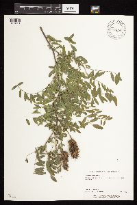 904584[1074991]Perry, Ethan 20060452006-09-13 United States, Minnesota, Itasca, Itasca County...8.9 miles SE of Marcell...tip of peninsula in Spider Lake. T58N R25W NWSW19;Chippewa National Forest;058N;25W;19, 47.4939398 -93.56642 |
MIN:Plants | 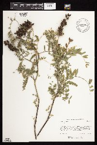 915746[1074943]Rowe, Erika ERR1322005-09-01 United States, Minnesota, Becker, Becker County...1.87 miles NE of Snellman; 4 miles SW of Ponsford...Linbom Lake...1/4NE 1/4NE S30 T140N R37W;Smokey Hills State Forest;140N;37W;30, 46.9116624 -95.4041628 |
MIN:Plants | 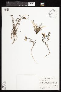 459581[1074844]Gould, William s.n.1995-06-00 Canada, Nunavut, Hood River...along the Hood River valley.;;;;, 66.7833328 -111, 400m |
MIN:Plants | Astragalus NULL 464370[]Lawrence, Donald 55-51955-07-30 United States, Alaska, Coast Mountains, flats in front of Mendenhall Glacier on east side of Lake Mendenhall.;Glacier Bay National Park;;;, 58.4833 -134.5167 |
Google Map
Google Maps is a web mapping service provided by Google that features a map that users can pan (by dragging the mouse) and zoom (by using the mouse wheel). Collection points are displayed as colored markers that when clicked on, displays the full information for that collection. When multiple species are queried (separated by semi-colons), different colored markers denote each individual species.