University of Minnesota
http://www.umn.edu/
612-625-5000
http://www.umn.edu/
612-625-5000
Minnesota Biodiversity Atlas
Bell Museum
Dataset: MIN-Plants
Taxa: Fabaceae
Search Criteria: excluding cultivated/captive occurrences
Bell Museum plants | |
 MIN:Plants |  140418[1078130]Sandberg, John s.n.1884-07-00 United States, Minnesota, Goodhue, Red Wing;;N;;, 44.592792 -92.586673 |
MIN:Plants |  140419[1078088]Ballard, C. B8731891-08-00 United States, Minnesota, Carver, Waconia;;116N;25W;, 44.844832 -93.796865 |
MIN:Plants |  140420[1078089]Kassube, J. s.n.1878-00-00 United States, Minnesota, Hennepin, Minneapolis;;N;;, 44.970736 -93.268643 |
MIN:Plants |  140421[1078085]Ballard, C. B1181891-06-00 United States, Minnesota, Carver, Chaska;;N;;, 44.8405547 -93.5309844 |
MIN:Plants |  140422[1078093]Campbell, Jennie s.n.1897-06-00 United States, Minnesota, Stearns, St. Cloud;;N;;, 45.5582 -94.181183 |
MIN:Plants |  140423[1078099]Sandberg, John s.n.1885-07-00 United States, Minnesota, Goodhue, Red Wing;;113N;14W;, 44.592792 -92.586673 |
MIN:Plants |  226236[1078120]Stork, H. 11151926-07-00 United States, Minnesota, Itasca, Bowstring;Chippewa National Forest;;;, 47.54306 -93.79639 |
MIN:Plants |  265470[1078095]Goldsmith, G. G761912-00-00 United States, Minnesota, Rice, Northfield;;N;;, 44.4496671 -93.1708471 |
MIN:Plants |  265847[1078104]Flygare, L. s.n.1923-07-01 United States, Minnesota, Sherburne, Sherburne Co.;;;;, 45.443953 -93.815794 |
MIN:Plants |  349645[1078134]Monserud, W. 41938-07-04 United States, Minnesota, Ramsey, Shadow Falls Park, St. Paul;Shadow Falls Park;028N;23W;, 44.942188 -93.197167 |
MIN:Plants |  350701[1078117]Hedman, H. 451938-07-00 United States, Minnesota, Hennepin, N shore of Brown's Bay, L. Minnetonka.;;N;;, 44.959273 -93.54689 |
MIN:Plants |  354018[1078139]Lakela, Olga 25751938-07-15 United States, Minnesota, Saint Louis, Minnesota Point, recreation grounds, S13;Minnesota Point;049N;13W;13, 46.728273 -92.047968 |
MIN:Plants |  357243[1078086]Stevenson, J. 591912-06-22 United States, Minnesota, Beltrami, Bemidji;;N;;, 47.479828 -94.863111 |
MIN:Plants |  407282[1078116]Lakela, Olga 97271949-09-02 United States, Minnesota, Saint Louis, Terrace of Ash River, the end of the road.;;N;;, 48.39867 -92.810673 |
MIN:Plants |  413083[1078142]Moore, John; Moore, Marjorie 110761939-07-24 United States, Minnesota, Lake of the Woods, mouth of Pine Creek, Angle Inlet, W of the creek;Northwest Angle;168N;34W;, 49.339876 -95.067038 |
MIN:Plants |  429469[1078049]Smith, Welby 208221992-07-14 United States, Minnesota, Roseau, Roseau Co.; T 159N R 39W NW1/4 of NE1/4 of sec 1;;159N;39W;1, 48.6236115 -95.6111145 |
MIN:Plants |  436392[1078080]Smith, Welby 209051992-07-15 United States, Minnesota, Marshall, Marshall Co.; In Old Mill State Park, about 11 miles east of argyle; T 156N R 46W NW1/4 of SE1/4 of Sec 4;Old Mill State Park;156N;46W;4, 48.3602791 -96.5702744 |
MIN:Plants |  437034[1078083]Moore, John; Hall, Robert 163241944-06-09 United States, Minnesota, Rock, Luverne;;N;;, 43.654136 -96.212807 |
MIN:Plants |  437777[1078067]Swanson, Gary 931999-07-15 United States, Minnesota, Morrison, Crane Meadows National Wildlife Refuge; SWSE 30-40-31;Crane Meadows National Wildlife Refuge;040N;31W;30, 45.9338958 -94.2515644 |
MIN:Plants |  449291[1078126]Moore, John; et al. 174391945-06-28 United States, Minnesota, Kanabec, Kanabec Co. 1 1/2 mi E of Mora;;039N;23W;, 45.876899 -93.262639 |
MIN:Plants |  457977[1122766]Sandberg, John s.n.1890-06-00 United States, Minnesota, Chisago, [no further data];;;;, 45.528143 -92.913635 |
MIN:Plants |  458045[1122765]Sandberg, John s.n.1881-06-00 United States, Minnesota, Goodhue, [no further data];;;;, 44.404993 -92.677429 |
MIN:Plants |  499893[1078138]Ball, E. 231946-07-22 United States, Minnesota, Marshall, Mud Lake Nat'l Wildlife Refuge, R41W, T156N, S15;Agassiz National Wildlife Refuge;156N;41W;15, 48.3311995 -95.9063517 |
MIN:Plants |  505268[1078081]Smith, Welby 208021992-07-13 United States, Minnesota, Wadena, Dry Sand Lake Wildlife Management Area. Wadena County...In Dry Sand Lake State Wildlife Management Area, on the west side of CSAH 30, about 2.5 miles south of Oylen...T 135N R 33W NW1/4 of SW1/4 of Sec 1. 135N 33W 1, 46.5338889 -94.7980556 |
MIN:Plants |  508292[1078047]Smith, Welby 168631990-06-18 United States, Minnesota, Waseca, Waseca Co.; Senn-Rich State Wildlife Management Area, about 5 mi S of Waseca; T106N R22W SE1/4 of NW1/4 of Sec 8;Senn-Rich Wildlife Management Area;106N;22W;8, 44.002224 -93.4977798 |
MIN:Plants |  520676[1078112]Smith, Welby 155531989-07-04 United States, Minnesota, Freeborn, Carex Wildlife Management Area. Freeborn Co.; 'Carex' State Wildlife Management Area, about 7 miles east-southeast of Hollandale; Freeborn Co.; 'Carex' State Wildlife Management Area, about 7 miles east-southeast of Hollandale; T 107N R 17W SW1/4 of SE1/4 of Sec 24. 103N 19W 23, 43.7155571 -93.0866699 |
MIN:Plants |  526558[1078122]Merrell, Ted s.n.1947-09-28 United States, Minnesota, Rice, Northfield;;N;;, 44.4496671 -93.1708471 |
MIN:Plants |  532954[1078137]Lakela, Olga 202161956-07-01 United States, Minnesota, Saint Louis, Willow Valley W of Gheen, Hwy 74;;063N;20W;00, 47.960386 -92.836036 |
MIN:Plants |  541435[1078092]Scharf, J. s.n.1956-07-20 United States, Minnesota, Murray, Chandler Marsh. State owned wetland 1 mi. NE of Chandler.;Chandler Marsh Wildlife Management Area;106N;42W;, 43.938755 -95.93714 |
MIN:Plants |  542766[1078125]Moore, John 218441954-07-20 United States, Minnesota, Wilkin, Along the banks of the Bois de Sioux River, 7 mi. S of Breckenridge.;;N;;, 46.161106 -96.573461 |
MIN:Plants |  552226[1078084]Lakela, Olga 226701958-09-19 United States, Minnesota, Saint Louis, UMD [Univ. of Minn.] Campus, Allen Ave, Duluth.;;050N;14W;14, 46.825338 -92.083576 |
MIN:Plants |  552227[1078098]Lakela, Olga 22670a1958-09-19 United States, Minnesota, Saint Louis, UMD [Univ. of Minn.] Campus, Allen Ave, Duluth.;;050N;14W;14, 46.825338 -92.083576 |
MIN:Plants |  553720[1078061]Moore, John 227051955-07-28 United States, Minnesota, Clay, 4 1/2 mi. E of Hawley;;N;;, 46.879111 -96.234127 |
MIN:Plants |  553753[1078115]Moore, John 227061955-07-28 United States, Minnesota, Clay, 4 1/2 mi E of Hawley;;N;;, 46.879111 -96.234127 |
MIN:Plants |  554042[1078060]Moore, John 225821955-07-16 United States, Minnesota, Pipestone, Along roadside at Pipestone National Monument;Pipestone National Monument;106N;46W;, 44.013519 -96.324755 |
MIN:Plants |  554066[1078129]Moore, John 224911955-06-01 United States, Minnesota, Renville, SW of Morton, Renville Co.;;113N;35W;, 44.547553 -94.993976 |
MIN:Plants |  554127[1078118]Moore, John 226401955-07-26 United States, Minnesota, Norman, 1/2 mi. S of Syre;;N;;, 47.173002 -96.258671 |
MIN:Plants |  554482[1078133]Moore, John 232251957-06-17 United States, Minnesota, Martin, along river at Granada;;N;;, 43.691663 -94.347231 |
MIN:Plants |  554650[1078064]Moore, John 231551957-06-12 United States, Minnesota, Pipestone, Pipestone Co.; 5 miles southwest of Pipestone;;106N;46W;, 43.944352 -96.394215 |
MIN:Plants |  558457[1078135]Moore, John; Moore, Marjorie 235381957-09-19 United States, Minnesota, Isanti, NW1/4 S16, Athens Twp, Cedar Creek Forest;Cedar Creek National History Area;034N;23W;16, 45.4357238 -93.2148194 |
MIN:Plants |  566541[1078131]Moore, John; Heig, V. 239951958-09-08 United States, Minnesota, Kittson, vacant lot at Hallock;;N;;, 48.766054 -96.9437 |
MIN:Plants |  566579[1078132]Moore, John 238681958-06-12 United States, Minnesota, Kittson, banks of river at Hallock;;N;;, 48.774671 -97.144066 |
MIN:Plants |  567693[1078119]Rasmussen, R. s.n.1961-06-16 United States, Minnesota, Clearwater, Forestry Station grounds, Itasca SP;Itasca State Park;143N;36W;, 47.225863 -95.195012 |
MIN:Plants |  572641[1078082]Moore, John 253901961-06-06 United States, Minnesota, Houston, La Crescent;;104N;04W;, 43.831985 -91.30334 |
MIN:Plants |  572856[1078114]Moore, John 255981961-07-14 United States, Minnesota, Anoka, Laboratory grounds Cedar Creek Natural Area.;Cedar Creek National History Area;034N;23W;, 45.410662 -93.198959 |
MIN:Plants |  574402[1078097]Moore, John 245611959-06-03 United States, Minnesota, Blue Earth, 5 mi. SE of Mankato;;N;;, 44.112349 -93.928017 |
MIN:Plants |  574696[1078102]Moore, John 246401959-06-17 United States, Minnesota, Pipestone, Pipestone Co.; 4 mi. north of Edgerton;;105N;44W;, 43.930405 -96.128637 |
MIN:Plants |  584732[1078039]Morean, Edith s.n.1961-06-18 United States, Minnesota, Pine, Pine Co. S of Hinckley. Near intersection of Hwy. 23 and 61.;;041N;21W;, 45.976838 -92.950219 |
MIN:Plants |  585645[1078103]Moore, John 262071962-10-03 United States, Minnesota, Houston, 3 mi. SE of Caledonia;Dorer Memorial Hardwood State Forest;N;;, 43.603957 -91.454353 |
MIN:Plants |  592279[1078065]Westkaemper, Remberta s.n.1965-07-00 United States, Minnesota, Stearns, Stearns Co. St. Joseph. St. Benedict College Campus.;;124n;29W;, 45.580034 -94.393284 |
MIN:Plants |  607264[1078105]Grafstrom, M. 1391968-08-07 United States, Minnesota, Hubbard, 1/4 mi. E of Hwy. 71 on N boundary road.;;N;;, 46.973367 -95.080688 |
MIN:Plants |  60984[1078066]Cottrell, R. s.n.1935-08-12 United States, Minnesota, Anoka, Fridley Sand Hills;;030N;24W;, 45.147678 -93.293924 |
MIN:Plants |  616635[1078106]Moore, John; Moore, Marjorie 2811969-07-12 United States, Minnesota, Crow Wing, Farmstead. N1/2 of the SE1/4 Sec. 18, Garrison Twp.;Crow Wing Natural Area;044N;28W;18, 46.2940114 -93.9265334 |
MIN:Plants |  628175[1078068]Ownbey, Gerald 45321972-07-08 United States, Minnesota, Washington, Afton Hills, 0.5 mi. S of Afton village.;;028N;20W;, 44.82006 -92.800703 |
MIN:Plants |  635057[1078141]Lindayen, T. 1461972-08-08 United States, Minnesota, Washington, T32N, R20W, SW1/4 S18, ca 6 mi W of Hwy 97 from jnc of Hwy 95 & 97;;032N;20W;18, 45.2605352 -92.8858404 |
MIN:Plants |  670619[1078063]Heitlinger, M. 4191971-10-05 United States, Minnesota, McLeod, Schaefer Prairie: S of native prairie. SE1/4 Sec. 34, T115N, R29W.;Schaefer Prairie, The Nature Conservancy;115N;29W;34, 44.7250496 -94.3049103 |
MIN:Plants |  685075[1078096]Stassen, Carol 1371977-06-22 United States, Minnesota, Lyon, Camden State Park; T110N, R42W, Sec. 5 SE1/4.;Camden State Park;110N;42W;5, 44.3631806 -95.9274434 |
MIN:Plants |  687120[1078087]Wheeler, Gerald; Glaser, Paul 15471977-06-04 United States, Minnesota, Itasca, SE1/4 SE1/4 Sec. 20, T55N, R26W; ca. 5 mi. W of Grand Rapids.;;055N;26W;20, 47.2325665 -93.6706029 |
MIN:Plants |  704637[1078062]Smith, Welby 16901979-08-16 United States, Minnesota, Wabasha, T109N, R09W, NE1/4 SW1/4 Sec. 7. On the E side of Co. Rd. 84.;;109N;09W;7, 44.2581065 -91.9389097 |
MIN:Plants |  715526[1078124]Ottoson, S. 751979-07-18 United States, Minnesota, Clay, Blazing Star Prairie: (TNC) 4 mi. SE of Felton, NE1/4 Sec. 5, T141N, R45W.;Felton Prairie-Blazing Star Prairie Scientific Natural Area;141N;45W;5, 47.0567136 -96.4173556 |
MIN:Plants |  720178[1078121]Ottoson, S. 1091979-07-16 United States, Minnesota, 2 miles southwest of Fertile.;Agassiz Dunes Scientific Natural Area;;;, 47.51564 -96.31032 |
MIN:Plants |  722462[1078123]Lustig, K. 5861979-06-29 United States, Minnesota, Anoka, Anoka County...Boot Lake SNA: 18 mi. SE of Cambridge, Sec. 17, 18, 19, 20, T33N, R22W.;Boot Lake Scientific Natural Area;033N;22W;00, 45.34066 -93.08146 |
MIN:Plants |  727176[1078058]Herman, J. 921979-07-17 United States, Minnesota, Norman, Twin Valley Prairie: (TNC) 5 mi. W of Syre, NW1/4 and E1/2 of SW1/4 of Sec. 23, T143N, R45W;Twin Valley Prairie Scientific Natural Area;143N;45W;23, 47.2744614 -96.3536656 |
MIN:Plants |  727445[1078057]Herman, J. 1421979-08-02 United States, Minnesota, Norman, Twin Valley Prairie: (TNC) 5 mi. W of Syre, NW1/4 E1/2 SW1/4 Sec. 23, T143N, R45W.;Twin Valley Prairie Scientific Natural Area;143N;45W;23, 47.2744614 -96.3536656 |
MIN:Plants |  727518[1078059]Farrell, P. 881979-07-10 United States, Minnesota, Polk, Pembina Trail Preserve Scientific Natural Area. Pembina Trail Preserve: (TNC) 6 1/2 mi. E of Harold. all sec. 36, frac. sec. 25, 30, 31, T149N, R45W, frac. sec. 1, 2, Pembina Trail Preserve: (TNC) 6 1/2 mi. E of Harold. all sec. 36, frac. sec. 25, 30, 31, T149N, R45W, frac. sec. 1, 2, T148N, R45W.. N , 47.6660064 -96.3343338 |
MIN:Plants | 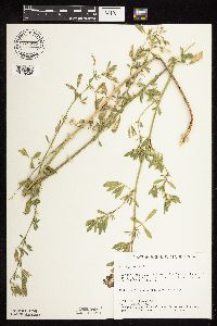 728977[1078036]Berlin, N. 821979-06-22 United States, Minnesota, Goodhue, Wacouta Pond Natural Area, The Nature Conservancy. Wacouta Pond Natural Area: 5 mi. SE of Red Wing. Hwy. 61 roadside. Portions of: Sec. 6, T112N, R13W and Sec. 31, 32, Wacouta Pond Natural Area: 5 mi. SE of Red Wing. Hwy. 61 roadside. Portions of: Sec. 6, T112N, R13W and Sec. 31, 32, T113N, R13W.. N , 44.5351457 -92.4198697 |
MIN:Plants | 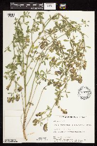 730521[1078048]Cross-Cella, J. 1841980-07-01 United States, Minnesota, Wilkin, Western Prairie North: 8 mi. N of Rothsay. SE1/4 SE1/4 Sec. 17, T136N, R45W.;Western Prairie North, The Nature Conservancy;136N;45W;17, 46.5946889 -96.3761319 |
MIN:Plants | 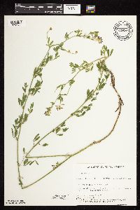 730529[1078035]Cross-Cella, J. 2391980-07-14 United States, Minnesota, Wilkin, Western Prairie North: 8 mi. N of Rothsay. SE1/4 SW1/4 Sec. 17, T136N, R45W.;Western Prairie North, The Nature Conservancy;136N;45W;17, 46.5946889 -96.3761319 |
MIN:Plants | 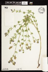 732685[1078056]Severson, M. 3401980-06-16 United States, Minnesota, Becker, Zimmerman Prairie: 10 mi. W of Ogema. SE1/4 SW1/4 Sec. 15, T142N, R43W.;Zimmerman Prairie [TNC];142N;43W;16, 47.1150258 -96.1414196 |
MIN:Plants |  738502[1078037]Galatowitsch, S. 3751982-07-01 United States, Minnesota, Wabasha, Wabasha County...Weaver Dunes: T109N, R09W, SE1/4 and E1/2 of Sec. 7; NW1/4 and W1/2 NE1/4 of Sec. 8.;Kellogg-Weaver Dunes Scientific Natural Area / Kellogg-Weaver Dunes, The Nature Conservancy;109N;09W;00, 44.2581065 -91.9389097 |
MIN:Plants |  739328[1078045]Stackler, S. 15511976-06-17 United States, Minnesota, Carlton, Soo Line SW Duesler Crossing, ca. 7 1/2 mi. E of Barnum (T45N, R17W, Sec. 5.);;045N;17W;5, 46.4105264 -92.5192101 |
MIN:Plants |  739333[1078042]Sohmer, S. s.n.1968-06-16 United States, Minnesota, Houston, Ca. 3 mi. S of Brownsville on Hwy. 26.;Dorer Memorial Hardwood State Forest;102N;04W;, 43.650682 -91.279857 |
MIN:Plants |  739696[1078041]Converse, C. 16321982-07-14 United States, Minnesota, Pope, Moe Woods: T123N, R36W, SE1/4 SW1/4 Sec. 34.;Moe Woods, The Nature Conservancy;123N;36W;34, 45.4198101 -95.1833376 |
MIN:Plants |  739698[1078044]Converse, C. 12311982-06-21 United States, Minnesota, Chippewa, Chippewa / Swift Co. Chippewa Prairie: T119N, R43W, SE1/4 SW1/4 Sec. 1.;Chippewa Prairie, The Nature Conservancy;119N;43W;1, 45.1447136 -95.990404 |
MIN:Plants |  739714[1078043]Converse, C. 14931982-07-07 United States, Minnesota, Pope, Ordway Prairie: T123N, R36W, NW1/4 SW1/4 Sec. 19.;Ordway Prairie, The Nature Conservancy;123N;36W;19, 45.4486737 -95.2450193 |
MIN:Plants |  739938[1078046]Converse, C. 12631982-06-22 United States, Minnesota, Douglas, Staffanson Prairie: T127N, R40W, NW1/4 NE1/4 and NE1/4 NW1/4 of Sec. 18.;Staffanson Prairie, The Nature Conservancy;127N;40W;18, 45.810665 -95.7480052 |
MIN:Plants |  747261[1078038]Galatowitsch, S. 4411982-07-14 United States, Minnesota, Houston, Caledonia Oaks: T102N, R5W, E1/2 SW1/4 Sec. 24.;Caledonia Oaks, The Nature Conservancy;102N;05W;24, 43.6231026 -91.3824233 |
MIN:Plants |  753551[1078052]Duxbury, Alexis 25251983-09-10 United States, Minnesota, Lyon, Glynn Prairie: S1/2 NE1/4 Sec. 7; T109N, R40W.;Glynn Prairie Scientific Natural Area;109N;40W;7, 44.2610945 -95.7045759 |
MIN:Plants |  758364[1078055]Smith, Welby 72811982-08-15 United States, Minnesota, Wright, Wright Co.; about 2 1/2 mi. WNW of Maple Lake. Adjacent to Hwy. 55. SW1/4 SW1/4 Sec. 35, T121N, R27W.;;121N;27W;35, 45.2460532 -94.0453538 |
MIN:Plants |  773377[1078053]Boe, J. 10511979-07-24 United States, Minnesota, Lake of the Woods, Near Graceton; roadside ditch near the jct. of Hwy. 11 and Hwy. 4.;;161N;32W;30, 48.7359452 -94.8160782 |
MIN:Plants |  774018[1078054]Boe, J. 7831979-07-15 United States, Minnesota, Lake of the Woods, Angle Inlet. T168N, R34W, N1/2 Sec. 30.;Northwest Angle;168N;34W;30, 49.3452026 -95.0815893 |
MIN:Plants |  778119[1078101]Duxbury, Alexis 14461983-07-02 United States, Minnesota, Lincoln, Hole-in-the Mountain: Portions of S1/2 Sec. 19, and SW1/4 Sec. 20; T109N, R45W.;Hole-in-the-Mountain Prairie, The Nature Conservancy;109N;45W;, 44.2337348 -96.291139 |
MIN:Plants |  778305[1078107]Duxbury, Alexis 15841983-07-13 United States, Minnesota, Lincoln, Hole-in-the-Mountain Prairie: Portions of S1/2 Sec. 19, and SW1/4 Sec. 20; T109N, R45W.;Hole-in-the-Mountain Prairie, The Nature Conservancy;109N;45W;, 44.2337348 -96.291139 |
MIN:Plants |  778312[1078108]Duxbury, Alexis 12771983-06-19 United States, Minnesota, Nobles, Compass Prairie: part of SE1/4 SW1/4 Sec. 3; T101N, R41W.;Compass Prairie Scientific Natural Area;101N;41W;3, 43.5801077 -95.7438528 |
MIN:Plants |  778313[1078051]Duxbury, Alexis 15261983-07-10 United States, Minnesota, Redwood, Redwood Co. Wahpeton Prairie: S/12 NW1/4 Sec. 29; T110N, R38W.;Wahpeton Prairie, The Nature Conservancy;110N;38W;29, 44.3047823 -95.4408133 |
MIN:Plants |  795714[1078140]Sanford, J. s.n.1947-08-02 United States, Minnesota, Clearwater, Itasca State Park, E side of N arm of Itasca Lake;Itasca State Park;143N;36W;, 47.229174 -95.194411 |
MIN:Plants |  804770[1078040]Ordway, E. s.n.1978-06-27 United States, Minnesota, Pope, Strandness Prairie. 4 mi. NE of Starbuck.;Strandness Prairie, The Nature Conservancy;N;;, 45.655345 -95.472601 |
MIN:Plants |  814173[1078094]Wheeler, Gerald 109161988-06-26 United States, Minnesota, Traverse, Ca. 5.5 mi. SW of Wheaton; wayside park N of Rte. 27. In meadow N of parking lot. W1/2 NE1/4 Sec. 32, T127N, R47W (La Ca. 5.5 mi. SW of Wheaton; wayside park N of Rte. 27. In meadow N of parking lot. W1/2 NE1/4 Sec. 32, T127N, R47W (Lake Twp.). 127N 47W 32, 45.7670176 -96.6040782 |
MIN:Plants |  814183[1078113]Wheeler, Gerald 112971988-07-23 United States, Minnesota, Lac Qui Parle, Ca. 5.5 mi. WSW of Madison; wildlife area E of Rte. 13. NW1/4 Sec. 33, T118N, R45W (Arena Twp.);;118N;45W;33, 44.9869505 -96.2990169 |
MIN:Plants |  833416[1078050]Juhnke, C. 1391991-06-19 United States, Minnesota, Fillmore, Forestville State Park. Fillmore Co. T102N R12W Sec.24 NW NE SW; along Root River;Forestville State Park;102W;12W;24, 43.6234111 -92.2191515 |
MIN:Plants |  836322[1078128]Smith, Welby 188401991-06-14 United States, Minnesota, Morrison, Camp Ripley Military Reservation. Camp Ripley Military Reservation Morrison Co. Along East Boundary Road, about 2.5 km N of the airfield. UTM: 394700E 510 Camp Ripley Military Reservation Morrison Co. Along East Boundary Road, about 2.5 km N of the airfield. UTM: 394700E 5107700N T131N R30W SE1/4 of NW1/4 of Sec 32. 131N 30W 32, 46.1145839 -94.4846274 |
MIN:Plants |  511231[1078072]Wheeler, Gerald 205091999-09-11 United States, Minnesota, Sibley, Ca. 2.2 mi. E of Winthrop; where Rte. 4 crosses RR tracks ... NW1/4 NW1/4 of Sec.;;112N;29W;03, 44.5361827 -94.3012466 |
MIN:Plants |  899958[1078071]Scott, P. 18712004-08-27 United States, Minnesota, Cook, COOK CO. ... Gunflint Tr. approx. 0.4 miles E of W end of CR92. T65N R2W sec.31 NE;Superior National Forest;065N;02W;31, 48.0704131 -90.2423549 |
MIN:Plants | 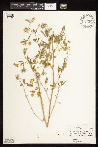 453751[1078110]Moore, John 3241971-07-08 United States, Minnesota, Sherburne, SE1/4 S-11 - Blue Hill Tshp. [Sherburne National Wildlife Refug];Sherburne National Wildlife Refuge;035N;27W;11, 45.5376106 -93.6652596 |
MIN:Plants | 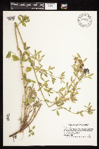 914660[1078127]Smith, Welby 226291993-07-01 United States, Minnesota, Otter Tail, Inspiration Peak Scenic Wayside Park. Otter Tail County ... Inspiration Peak State Wayside Park, about 12 miles west of Parkers Prairie ... T131N R39W SE1/4 of SW1/4 of Sec 22. 131N 39W 22, 46.1383333 -95.5736111 |
MIN:Plants | 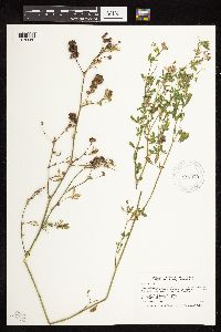 923873[1078069]Smith, Welby 216851992-08-26 United States, Minnesota, Nicollet, At the public access on the Minnesota River; about 7 miles north of Mankato. SE1/4 of NW1/4 of section;Seven Mile Creek County Park;109N;27W;12, 44.2611111 -94.0219444 |
MIN:Plants | 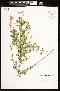 920477[1122768]Smith, Welby 239031993-09-09 United States, Minnesota, Meeker, About one mile east-southeast of Cedar Mills...along the C & NW Railroad right-of-way (now abandoned)...T 117N R 31W SE1/4 of SE1/4 of Sec 13. 117N 31W 13, 44.9394444 -94.5036111 |
MIN:Plants |  931030[1122762]Smith, Welby R. 158451989-07-20 United States, Minnesota, Mille Lacs, Public access on SW end of Shokopee Lake; about 4 miles NW of Onamia. Sandy Lake. NW1/4 of SE1/4 of section;Mille Lacs Kathio State Park;042N;27W;22, 46.105 -93.7311111 |
MIN:Plants |  934427[1122764]Smith, Welby R. 217311992-08-27 United States, Minnesota, Brown, About 7 miles south-southwest of New Ulm NW of SW of section;Tauer Prairie Scientific Natural Area;109N;31W;35, 44.2013889 -94.5302778 |
MIN:Plants |  447904[1122763]Ruby, Janeen 252012-06-27 United States, Minnesota, Jackson, ~10 mi S of Lakefield on State Hwy 86. State prop at corner of Cty Hwy 4 and Hwy 86. Along access road from parking lot at north end of property. NW SE of sec.;Sangl Wildlife Management Area;101N;36W;21, 43.536614 -95.164336 |
Google Map
Google Maps is a web mapping service provided by Google that features a map that users can pan (by dragging the mouse) and zoom (by using the mouse wheel). Collection points are displayed as colored markers that when clicked on, displays the full information for that collection. When multiple species are queried (separated by semi-colons), different colored markers denote each individual species.