University of Minnesota
http://www.umn.edu/
612-625-5000
http://www.umn.edu/
612-625-5000
Minnesota Biodiversity Atlas
Bell Museum
Dataset: MIN-Plants
Taxa: Fabaceae
Search Criteria: excluding cultivated/captive occurrences
Bell Museum plants | |
 MIN:Plants |  Dalea purpurea var. purpurea Ventenat 710015[1075969]Wheeler, Gerald 50451979-10-06 United States, Minnesota, Le Sueur, Le Sueur Co. Approx. 1 mi SW of Kasota, bluff overlooking the Minnesota River, High Lime Prairie; T109N R26W Sec. 6;East Minnesota River Wildlife Management Area;109N;26W;6, 44.3626183 -93.939379 |
MIN:Plants |  Dalea purpurea var. purpurea Ventenat 715236[1075968]Severson, M.; et al. 691979-07-23 United States, Minnesota, Polk, 4.5 mi S of Fischer; W1/2 NW1/4 of sec.;Malmberg Prairie Scientific Natural Area;149N;48W;16, 47.7241699 -96.8139653 |
MIN:Plants |  Dalea purpurea var. purpurea Ventenat 715416[1075966]Ottoson, S. 871979-07-25 United States, Minnesota, Clay, Blazing Star Prairie, 4 mi SE of Felton; NE1/4 Sec. 5 T141N R45W;Felton Prairie-Blazing Star Prairie Scientific Natural Area;141N;45W;5, 47.0567136 -96.4173556 |
MIN:Plants |  Dalea purpurea var. purpurea Ventenat 717049[1075967]Heitlinger, M. 8311975-07-29 United States, Minnesota, Anoka, Anoka Co. Allison Savanna, in N central portion of the savanna area of the tract; N1/2 NE1/4 Sec. 2 T33N R23W;Helen Allison Savanna Scientific Natural Area;033N;23W;2, 45.3777015 -93.1738785 |
MIN:Plants |  Dalea purpurea var. purpurea Ventenat 717616[1076143]Farrell, P. 1041979-07-23 United States, Minnesota, Norman, Frenchman's Bluff, 2.5 mi N of Flom; frac. of Sec. 18 T143N R43W;Frenchmans Bluff Scientific Natural Area;143N;43W;18, 47.2019677 -96.1838932 |
MIN:Plants |  Dalea purpurea var. purpurea Ventenat 720300[1076120]Ottoson, S. 1221979-07-23 United States, Minnesota, 2 miles southwest of Fertile.;Agassiz Dunes Scientific Natural Area;;;, 47.51564 -96.31032 |
MIN:Plants |  Dalea purpurea var. purpurea Ventenat 721219[1076122]Lustig, K. 8511979-08-08 United States, Minnesota, Sherburne, Clear Lake-Mississippi Scenic and Recreational River, SNA: 12 mi. SE of St. Cloud, Sec. 14, 22, 23, T34N, R30W.;Clear Lake Scientific Natural Area;034N;30W;, 45.4362154 -94.0372393 |
MIN:Plants |  Dalea purpurea var. purpurea Ventenat 721502[1076121]Farrell, P. 1991979-08-15 United States, Minnesota, Polk, 7 mi. SE of Crookston. S1/2 of section;Pankratz Memorial Prairie, The Nature Conservancy;149N;45W;08, 47.73852 -96.44879 |
MIN:Plants | 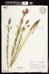 Dalea purpurea var. purpurea Ventenat 723685[1076019]Smith, Welby 28731980-07-17 United States, Minnesota, Mower, T101N, R15W, NE1/4 NW1/4 S24, between the Chicago, Milwaukee & Pacific RR tracks and hwy 56; 1.8 mi SE of its jnc with H T101N, R15W, NE1/4 NW1/4 S24, between the Chicago, Milwaukee & Pacific RR tracks and hwy 56; 1.8 mi SE of its jnc with Hwy 11. 101N 15W 24, 43.5365013 -92.5787398 |
MIN:Plants | 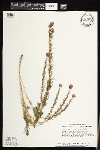 Dalea purpurea var. purpurea Ventenat 723959[1076095]Smith, Welby 28161980-07-16 United States, Minnesota, Winona, Winona Co. Ca. 1/4 mi E of the Whitewater River; T108N R10W NW1/4 SE1/4 NW1/4 Sec. 14;Whitewater Wildlife Management Area;108N;10W;14, 44.15652 -91.9902857 |
MIN:Plants | 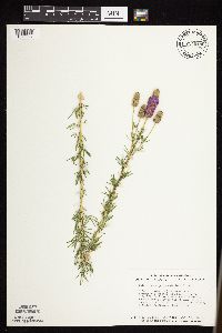 Dalea purpurea var. purpurea Ventenat 724019[1076007]Smith, Welby 28871980-07-18 United States, Minnesota, Freeborn, Between the Chicago, Milwaukee, St. Paul and Pacific rr tracks and hwy 46, ca. 9 mi E of Albert Lea; T102N R20W NE1/4 SE Between the Chicago, Milwaukee, St. Paul and Pacific rr tracks and hwy 46, ca. 9 mi E of Albert Lea; T102N R20W NE1/4 SE1/4 Sec. 2. 102N 20W 2, 43.6662314 -93.1992364 |
MIN:Plants | 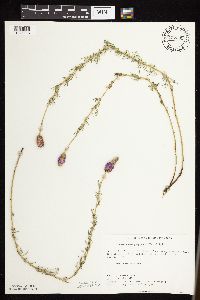 Dalea purpurea var. purpurea Ventenat 727205[1076116]Herman, J. 1171979-07-28 United States, Minnesota, Norman, Norman Co.; Twin Valley Prairie; 5 mi. W of Syre, NW1/4 E1/2 SW1/4 Sec. 23, T143N, R45W.;Twin Valley Prairie Scientific Natural Area;143N;45W;23, 47.1875161 -96.3538078 |
MIN:Plants |  Dalea purpurea var. purpurea Ventenat 727265[1076115]Smith, Welby 35301980-08-24 United States, Minnesota, Wright, Wright Co.; T123N, R27W, SW1/4 NW1/4 Sec. 35. Rest area on W side of Co. Rd. 75 in Clearwater.;;123N;27W;35, 45.4168985 -94.0485599 |
MIN:Plants |  Dalea purpurea var. purpurea Ventenat 727416[1076182]Ottoson, S. 891979-07-25 United States, Minnesota, Clay, Clay County Bicentennial Prairie: County owned, 4 mi. SE of Felton, SW1/4 Sec. 5, T141N, R45W.;Felton Prairie-Bicentennial Prairie Scientific Natural Area;141N;45W;5, 47.0567136 -96.4173556 |
MIN:Plants |  Dalea purpurea var. purpurea Ventenat 727508[1076117]Farrell, P.; et al. 1321979-07-17 United States, Minnesota, Polk, Pembina Trail Preserve Scientific Natural Area. Polk Co. Pembina Trail Preserve: 6 1/2 mi E of Harold, all sec. 36, frac. sec. 25, 30, 31, T149N, R45W, frac. sec. 1, 2, T148N, R45W. , 47.6660064 -96.3343338 |
MIN:Plants |  Dalea purpurea var. purpurea Ventenat 727919[1075972]Severson, M. 951979-07-18 United States, Minnesota, Polk, Pankratz Prairie South, 7 mi SE of Crookston; SE1/4 Sec. 17 NE1/4 Sec. 20 T149N R45W;Pankratz Memorial Prairie, The Nature Conservancy;149N;45W;, 47.7094164 -96.4489856 |
MIN:Plants | 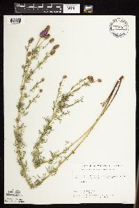 Dalea purpurea var. purpurea Ventenat 728890[1076031]Ottoson, S. 1371979-07-24 United States, Minnesota, Mahnomen, Mahnomen County ... Santee Prairie, ... 3 miles Southeast of Bejou. Sec. 6, 7, T 145N, R 41W;Santee Prairie Scientific Natural Area / White Earth Indian Reservation;145N;41W;, 47.4051432 -95.9225134 |
MIN:Plants | 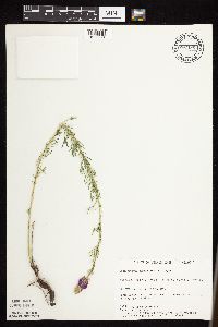 Dalea purpurea var. purpurea Ventenat 730486[1075974]Cross-Cella, J. 2111980-07-07 United States, Minnesota, Wilkin, Western Prairie North, 8 mi N of Rothsay; SW1/4 SW1/4 Sec. 17 T136N R45W;Western Prairie North, The Nature Conservancy;136N;45W;17, 46.5946889 -96.3761319 |
MIN:Plants | 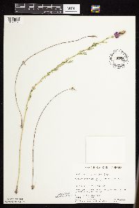 Dalea purpurea var. purpurea Ventenat 730926[1076181]Cross-Cella, J. 2461980-07-15 United States, Minnesota, Clay, Audubon Prairie: 16.5 mi. ESE of Moorhead. NW1/4 NE1/4 Sec. 31, T139N, R45W.;Audubon Prairie, The Nature Conservancy;139N;45W;31, 46.811065 -96.4146955 |
MIN:Plants | 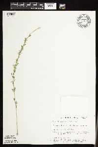 Dalea purpurea var. purpurea Ventenat 732677[1075973]Severson, M. 4251980-07-01 United States, Minnesota, Becker, Zimmerman Prairie, 10 mi W of Ogema; SE1/4 SW1/4 Sec. 16 T142N R43W;Zimmerman Prairie [TNC];142N;43W;16, 47.1150258 -96.1414196 |
MIN:Plants |  Dalea purpurea var. purpurea Ventenat 734598[1076179]Petron, T. 2061980-07-02 United States, Minnesota, Clay, Bluestem Prairie: 13 mi. E of Moorhead. SE1/4 NE1/4 Sec. 15, T139N, R46W.;Bluestem Prairie Scientific Natural Area;139N;46W;15, 46.8549481 -96.4734033 |
MIN:Plants |  Dalea purpurea var. purpurea Ventenat 735695[1076178]Benson, Douglas 2991981-07-20 United States, Minnesota, Wilkin, Town Hall Prairie: T134N, R45W, NW1/2 SE1/4 NW1/4 Sec. 15.;Town Hall Prairie, The Nature Conservancy;134N;45W;15, 46.4203322 -96.3331826 |
MIN:Plants |  Dalea purpurea var. purpurea Ventenat 735697[1076176]Benson, Douglas 3111981-07-23 United States, Minnesota, Wilkin, Kettledrummer: T133N, R45W, S-central SE1/4 NW1/4 Sec. 12.;Kettledrummer Prairie, The Nature Conservancy;133N;45W;12, 46.3479066 -96.2909818 |
MIN:Plants |  Dalea purpurea var. purpurea Ventenat 735852[1076177]Benson, Douglas 2311981-07-15 United States, Minnesota, Wilkin, Anna Gronseth Prairie: T134N, R45W SE1/4 Sec. 8;Anna Gronseth Prairie, The Nature Conservancy;134N;45W;8, 46.4348332 -96.375181 |
MIN:Plants |  Dalea purpurea var. purpurea Ventenat 735908[1076180]Benson, Douglas 4801981-09-11 United States, Minnesota, Wilkin, Foxhome Prairie: Near NE1/4 of NE1/4 SE1/4 Sec. 24; T133N, R45W.;Foxhome Prairie, The Nature Conservancy;133N;45W;24, 46.3186527 -96.2907137 |
MIN:Plants |  Dalea purpurea var. purpurea Ventenat 739678[1076026]Converse, C. 17931982-07-25 United States, Minnesota, Chippewa, Chippewa and Swift Cos. Chippewa Prairie: T119N, R43W, SW1/4 NW1/4 Sec. 1;Chippewa Prairie, The Nature Conservancy;119N;43W;1, 45.1447136 -95.990404 |
MIN:Plants |  Dalea purpurea var. purpurea Ventenat 741343[1075975]Converse, C. 16001982-07-12 United States, Minnesota, Pope, Ordway Prairie; T123N R36W SW1/4 NE1/4 Sec. 30;Ordway Prairie, The Nature Conservancy;123N;36W;30, 45.4342616 -95.2450181 |
MIN:Plants |  Dalea purpurea var. purpurea Ventenat 741352[1075976]Converse, C. 16941982-07-20 United States, Minnesota, Otter Tail, Otter Tail Preserve; SW1/4 NE1/4 Sec. 17 T131N R44W;Ottertail Prairie Scientific Natural Area;131N;44W;17, 46.1592444 -96.2353633 |
MIN:Plants | 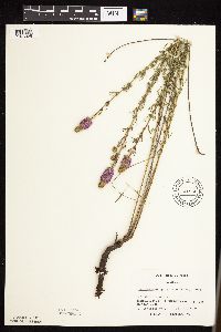 Dalea purpurea var. purpurea Ventenat 741556[1076025]Converse, C. 17241982-07-21 United States, Minnesota, Douglas, Staffanson Prairie: T127N, R40W, NW1/4 NE1/4 and NE1/4 NW1/4 of Sec. 18.;Staffanson Prairie, The Nature Conservancy;127N;40W;18, 45.810665 -95.7480052 |
MIN:Plants | 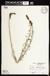 Dalea purpurea var. purpurea Ventenat 743760[1076041]Ownbey, Gerald 66481980-09-20 United States, Minnesota, Houston, Dorer Memorial Hardwood State Forest. Houston Co. Twin Bluffs, 1.8 mi N of Iowa line at New Albin, at top of slopes on W side of rte 26; T101N R4W Sec. 26 NW1 Houston Co. Twin Bluffs, 1.8 mi N of Iowa line at New Albin, at top of slopes on W side of rte 26; T101N R4W Sec. 26 NW1/4. 101N 04W 26, 43.522538 -91.2828408 |
MIN:Plants | 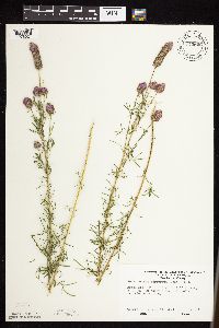 Dalea purpurea var. purpurea Ventenat 743806[1076024]Ownbey, Gerald 66931981-07-26 United States, Minnesota, Washington, Afton State Park. T27N, R20W, Sec. 2, NW1/4.;Afton State Park;027N;20W;2, 44.8547629 -92.7750459 |
MIN:Plants | 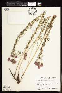 Dalea purpurea var. purpurea Ventenat 743879[1076042]Ownbey, Gerald 68441982-07-31 United States, Minnesota, Dakota, Dakota Co. Coulee, E side of Minn. rte 316, 1.9 mi SE of its jnc with U.S. rte 61 at Hastings; T114N R17W Sec. 11 NE1/4 ;;114N;17W;11, 44.6949898 -92.8228357 |
MIN:Plants | 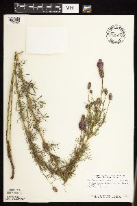 Dalea purpurea var. purpurea Ventenat 746503[1075987]Smith, Welby 49781981-07-21 United States, Minnesota, Mower, Wild Indigo Scientific and Natural Area, ca. 2.5 mi W of Dexter; SW1/4 NE1/4 Sec. 16 T103N R16W;Wild Indigo Scientific Natural Area;103N;16W;16, 43.7248832 -92.759467 |
MIN:Plants | 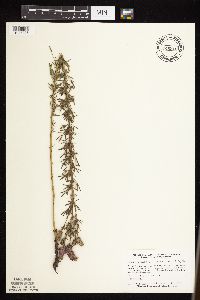 Dalea purpurea var. purpurea Ventenat 746516[1075986]Smith, Welby 52621981-08-05 United States, Minnesota, Steele, Ca. 3 mi NW of Bixby and 200 meters NW of the Turtle Creek crossing, between U.S. hwy 218 and the Chicago, Milwaukee, St Ca. 3 mi NW of Bixby and 200 meters NW of the Turtle Creek crossing, between U.S. hwy 218 and the Chicago, Milwaukee, St. Paul and Pacific rr tracks; SE1/4 SE1/4 Sec. 17 T106N R19W. 106N 19W 17, 43.9864174 -93.1360604 |
MIN:Plants | 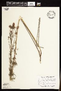 Dalea purpurea var. purpurea Ventenat 746534[1075985]Smith, Welby 53361981-08-06 United States, Minnesota, Faribault, Ca. 3.5 mi W of Delavan, on the right-of-way of the Chicago, Milwaukee, St. Paul and Pacific rr; NE1/4 SE1/4 Sec. 32 T10 Ca. 3.5 mi W of Delavan, on the right-of-way of the Chicago, Milwaukee, St. Paul and Pacific rr; NE1/4 SE1/4 Sec. 32 T104N R27W. 104N 27W 32, 43.7675571 -94.0973864 |
MIN:Plants |  Dalea purpurea var. purpurea Ventenat 746562[1075984]Smith, Welby 47631981-07-11 United States, Minnesota, Faribault, Ca. 3.5 mi SE of Kiester; NE1/4 NE1/4 Sec. 36 T101N R24W;;101N;24W;36, 43.7679802 -93.6582749 |
MIN:Plants | 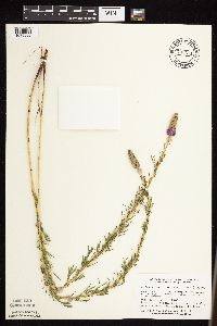 Dalea purpurea var. purpurea Ventenat 746571[1075983]Smith, Welby 48021981-07-11 United States, Minnesota, Martin, On the N side of co. hwy 50, ca. 2 1/4 mi W of its jnc with st. hwy 15 in Truman; SW1/4 SE1/4 Sec. 7 T104N R30W;;104N;30W;7, 43.8254659 -94.4801099 |
MIN:Plants |  Dalea purpurea var. purpurea Ventenat 746752[1076027]Lee, Craig 971982-08-05 United States, Minnesota, Kandiyohi, Regal Meadow: T122N, R33W S1/2 NE1/4 NE1/4 SE1/4 and part of NE1/4 NE1/4 of Sec. 16.;Regal Meadow, The Nature Conservancy;122N;33W;16, 45.3769223 -94.8351163 |
MIN:Plants |  Dalea purpurea var. purpurea Ventenat 747308[1076028]Galatowitsch, S. 5501982-07-27 United States, Minnesota, Wabasha, SE1/4 and E1/2 NE1/4 of Sec. 7; NW1/4 and W1/2 NE1/4 of Sec. 8.;Kellogg-Weaver Dunes Scientific Natural Area / Kellogg-Weaver Dunes, The Nature Conservancy;109N;09W;, 44.2331079 -91.9172451 |
MIN:Plants |  Dalea purpurea var. purpurea Ventenat 750558[1076111]Peterson, Jon 2661982-07-19 United States, Minnesota, Houston, Houston Co. Gap Hill #1 goat prairie; ca. 4 mi. W of Hokah on N side of Hwy. 16. NW1/4 SW1/4 Sec. 34, T104N, R5W.;Dorer Memorial Hardwood State Forest;104N;05W;34, 43.7677422 -91.4228103 |
MIN:Plants |  Dalea purpurea var. purpurea Ventenat 753147[1076109]Boe, J. 20031983-08-03 United States, Minnesota, Kittson, Norway Dunes: SW1/4 SE1/4 Sec. 10; T160N, R46W.;Norway Dunes, The Nature Conservancy;160N;46W;10, 48.6957357 -96.5727704 |
MIN:Plants |  Dalea purpurea var. purpurea Ventenat 759074[1076113]Smith, Welby 75331982-08-24 United States, Minnesota, Cottonwood, Lake Augusta Wildlife Management Area. Lake Augusta National Waterfowl Production Area. On the E side of Lake Augusta, ca. 4 mi. SW of Jeffers. NE1/4 NE1/4 S Lake Augusta National Waterfowl Production Area. On the E side of Lake Augusta, ca. 4 mi. SW of Jeffers. NE1/4 NE1/4 Sec. 11, T106N, R37W.. 106N 37W 11, 44.0000369 -95.2506045 |
MIN:Plants |  Dalea purpurea var. purpurea Ventenat 759119[1076114]Smith, Welby 71751982-08-11 United States, Minnesota, McLeod, Ras-Lynn Wildlife Management Area. Ras-Lynn State Wildlife Management Area. On the W side of Eagle Lake, ca. 7 mi. SW of Hutchinson. NW1/4 SW1/4 Sec. 33, Ras-Lynn State Wildlife Management Area. On the W side of Eagle Lake, ca. 7 mi. SW of Hutchinson. NW1/4 SW1/4 Sec. 33, T116N, R30W.. 116N 30W 33, 44.8124739 -94.4471087 |
MIN:Plants |  Dalea purpurea var. purpurea Ventenat 759203[1076112]Smith, Welby 69211982-07-28 United States, Minnesota, Mower, Racine Prairie Scientific Natural Area. Racine Prairie State Scientific and Natural Area. Adjacent to the E side of Hwy. 63, ca. 2 mi. N of Racine. NE1/4 NE1/ Racine Prairie State Scientific and Natural Area. Adjacent to the E side of Hwy. 63, ca. 2 mi. N of Racine. NE1/4 NE1/4 Sec. 22, T104N, R14W.. 104N 14W 22, 43.7976425 -92.4992666 |
MIN:Plants |  Dalea purpurea var. purpurea Ventenat 764035[1076101]Foote, Lewis s.n.1893-00-00 United States, Minnesota, Nobles, Worthington;;102N;40W;, 43.630153 -95.594338 |
MIN:Plants |  Dalea purpurea var. purpurea Ventenat 764036[1076085]Foote, Lewis s.n.1886-07-15 United States, Minnesota, Nobles, Worthington;;N;;, 43.628414 -95.598458 |
MIN:Plants |  Dalea purpurea var. purpurea Ventenat 765002[1076083]Lugger, O. s.n.1900-07-00 United States, Minnesota, Nicollet, Nicollet;;109N;28W;03, 44.27587 -94.18034 |
MIN:Plants |  Dalea purpurea var. purpurea Ventenat 765004[1076082]Lugger, O. 1670 United States, Minnesota, Blue Earth, Mankato;;N;;, 44.17072 -93.992534 |
MIN:Plants |  Dalea purpurea var. purpurea Ventenat 766736[1076084]Kato, Y. s.n.1894-07-12 United States, Minnesota, Ramsey, St. Anthony Park [St. Paul neighborhood near U of M];;029N;23W;, 44.983574 -93.195102 |
MIN:Plants |  Dalea purpurea var. purpurea Ventenat 769908[1076100]Smith, Welby 88021983-09-07 United States, Minnesota, Jackson, Sioux Valley State Wildlife Management Area, ca. 1 mi. SSE of Sioux Valley. NE1/4 NE1/4 Sec. 29, T101N, R37W.;Sioux Valley Wildlife Management Area;101N;37W;29, 43.522292 -95.3046432 |
MIN:Plants |  Dalea purpurea var. purpurea Ventenat 770285[1076099]Smith, Welby 82751983-07-14 United States, Minnesota, Wabasha, Kellogg-Weaver Dunes Scientific Natural Area / Kellogg-Weaver Dunes, The Nature Conservancy. Kellogg-Weaver Dunes State Scientific and Natural Area. Ca. 4 mi. SE of Kellogg, on the E side of Co. Rd. 84. SE1/4 NE Kellogg-Weaver Dunes State Scientific and Natural Area. Ca. 4 mi. SE of Kellogg, on the E side of Co. Rd. 84. SE1/4 NE1/4 Sec. 6, T109N, R09W.. 109N 09W 6, 44.2726079 -91.9389825 |
MIN:Plants |  Dalea purpurea var. purpurea Ventenat 772479[1076110]Boe, J. 18571982-08-20 United States, Minnesota, Lake of the Woods, Edge of trail at old sawmill site between Faunce-Butterfield Rd. and Hogsback-O'Brien Forest Rd. SE1/4 Sec. 14, T159N, Edge of trail at old sawmill site between Faunce-Butterfield Rd. and Hogsback-O'Brien Forest Rd. SE1/4 Sec. 14, T159N, R36W.. 159N 36W 14, 48.5906367 -95.2445557 |
MIN:Plants |  Dalea purpurea var. purpurea Ventenat 776317[1076098]Morley, T. 16551985-07-28 United States, Minnesota, Scott, Scott Co. On sand dunes NNW of Jordan near the Minnesota River. T114N, R24W, SE1/4 Sec. 12. N of N loop of Sioux Vista Scott Co. On sand dunes NNW of Jordan near the Minnesota River. T114N, R24W, SE1/4 Sec. 12. N of N loop of Sioux Vista Drive.. 114N 24W 12, 44.6915235 -93.654586 |
MIN:Plants |  Dalea purpurea var. purpurea Ventenat 778347[1076105]Duxbury, Alexis 16811983-07-19 United States, Minnesota, Jackson, Blue Gentian Prairie: part of SW1/4 SE1/4 Sec. 13, T103N, R36W.;Blue Gentian Prairie;103N;36W;13, 43.7249294 -95.1050766 |
MIN:Plants |  Dalea purpurea var. purpurea Ventenat 778369[1076150]Duxbury, Alexis 16401983-07-19 United States, Minnesota, Nobles, Compass Prairie; part of SE1/4 SW1/4 Sec. 3 T101N R41W;Compass Prairie Scientific Natural Area;101N;41W;3, 43.5801077 -95.7438528 |
MIN:Plants |  Dalea purpurea var. purpurea Ventenat 778370[1076106]Duxbury, Alexis 17151983-07-22 United States, Minnesota, Murray, Lundblad Prairie: W1/2 NW1/4 Sec. 1; T105N, R41W.;Lundblad Prairie Scientific Natural Area;105N;41W;1, 43.9278165 -95.7133858 |
MIN:Plants |  Dalea purpurea var. purpurea Ventenat 778371[1076149]Duxbury, Alexis 20301983-08-06 United States, Minnesota, Lyon, Glynn Prairie; S1/2 NE1/4 Sec. 7 T109N R40W;Glynn Prairie Scientific Natural Area;109N;40W;7, 44.2610945 -95.7045759 |
MIN:Plants |  Dalea purpurea var. purpurea Ventenat 781131[1076108]Smith, Welby 99201984-09-06 United States, Minnesota, Jackson, Ca. 1 mi. SE of Petersburg. N-facing hillside in the Des Moines River Valley. NW1/4 SE1/4 Sec. 27, T101N, R34W.;;101N;34W;27, 43.5228821 -94.9043901 |
MIN:Plants |  Dalea purpurea var. purpurea Ventenat 782300[1076107]Tenney, M. 4801982-07-27 United States, Minnesota, Winona, Whitewater State Park. Winona Co. T107N, R10W, Sec. 20, NW1/4 SE1/4 SW1/4.;Whitewater State Park;107N;10W;20, 44.0565006 -92.0495184 |
MIN:Plants |  Dalea purpurea var. purpurea Ventenat 787491[1076096]Smith, Welby 111071985-08-14 United States, Minnesota, Yellow Medicine, Sioux Nation State Wildlife Management Area, ca. 8 mi. WSW of Canby. NW1/4 SW1/4 Sec. 17, T114N, R46W.;Sioux Nationalion Wildlife Management Area;114N;46W;17, 44.681835 -96.4295916 |
MIN:Plants |  Dalea purpurea var. purpurea Ventenat 788863[1076093]Smith, Welby 113131985-09-08 United States, Minnesota, Ramsey, Maplewood Nature Center. Ramsey County...In the city of Maplewood, about 1/2 mi. S of Larpenteur Ave. and 1/2 mi. E of McKnight Road. SE1/4 NW1/4 Sec. 24, T29N, R22W. 029N 22W 24, 44.9855556 -92.995 |
MIN:Plants |  Dalea purpurea var. purpurea Ventenat 789572[1076151]Smith, Welby 109051985-07-24 United States, Minnesota, Cottonwood, Expandere State Wildlife Management Area, ca. 13 mi WNW of Windom; SE1/4 SW1/4 Sec. 1 T105N R38W;Expandere Wildlife Management Area;105N;38W;1, 43.9225006 -95.351944 |
MIN:Plants |  Dalea purpurea var. purpurea Ventenat 789608[1076097]Smith, Welby 112391985-08-29 United States, Minnesota, Murray, On a N-facing bluff overlooking Chanarambie Creek, ca. 1 mi. WSW of Chandler. SW1/4 SE1/4 Sec. 2, T105N, R43W;;105N;43W;2, 43.9241676 -95.9688873 |
MIN:Plants |  Dalea purpurea var. purpurea Ventenat 792263[1076094]Smith, Welby 107921985-07-19 United States, Minnesota, Marshall, Ca. 1/8 mi. N of the Marshall-Pennington Co. line, and 3 mi. SSE of Viking. SW1/4 NE1/4 Sec. 12, T154N, R45W;;154N;45W;12, 48.1755562 -96.3777771 |
MIN:Plants |  Dalea purpurea var. purpurea Ventenat 793941[1076125]Clark, A. 191986-06-30 United States, Minnesota, Wilkin, Tansberg Twp, R.R. right-of-way NW of Rothsay. T135N, R45W, Sec. 10.;;135N;45W;10, 46.5223799 -96.3334256 |
MIN:Plants |  Dalea purpurea var. purpurea Ventenat 795546[1076126]Cholewa, A. 14351987-07-22 United States, Minnesota, Clay, Buffalo River State Park. Clay County...Buffalo River State Park; old gravel pit in SW corner of the park adjacent to Bluestem SNA; T139N R46W, SW1/4 NE1/4 Sec. 15.. 139N 46W 15, 46.8549481 -96.4734033 |
MIN:Plants |  Dalea purpurea var. purpurea Ventenat 795768[1076175]Sanford, J. s.n.1947-08-15 United States, Minnesota, Clearwater, Itasca State Park, De Soto Lake road.;Itasca State Park;143N;36W;, 47.145378 -95.22016 |
MIN:Plants |  Dalea purpurea var. purpurea Ventenat 800313[1075998]Cholewa, A.; et al. 17531989-07-14 United States, Minnesota, Washington, Carpenter Nature Center. Carpenter Nature Center. Washington Co, T26N R20W S4...north ravine, reestablished old field along N trail, ca. 100 feet E of ravine crossing, at S end field. 026N 20W 4, 44.7688067 -92.8136158 |
MIN:Plants |  Dalea purpurea var. purpurea Ventenat 800920[1076091]Smith, Welby 124251986-08-11 United States, Minnesota, Goodhue, Goodhue County...Hay Creek Recreation Area, about 2 mi. S of Red Wing. SW1/4 NW1/4 Sec. 7, T112N, R14W;Dorer Memorial Hardwood State Forest;112N;14W;7, 44.523613 -92.5458298 |
MIN:Plants |  Dalea purpurea var. purpurea Ventenat 801040[1075992]Smith, Welby 123861986-08-10 United States, Minnesota, Wabasha, Snake Creek Recreation Area, ca. 3 mi S of Kellogg; SE1/4 NE1/4 Sec. 10 T109N R10W;Dorer Memorial Hardwood State Forest;109N;10W;10, 44.2602768 -91.9916687 |
MIN:Plants |  Dalea purpurea var. purpurea Ventenat 801179[1075993]Smith, Welby 121571986-07-20 United States, Minnesota, Sherburne, Sherburne National Wildlife Refuge, ca. 2.5 mi SE of Santiago; NE1/4 SW1/4 Sec. 23 T35N R28W;Sherburne National Wildlife Refuge;035N;28W;23, 45.5074997 -93.7938919 |
MIN:Plants |  Dalea purpurea var. purpurea Ventenat 802976[1076004]Smith, Welby 121101986-07-10 United States, Minnesota, Pipestone, Prairie Coteau Scientific Natural Area. Pipestone County...Prairie Coteau State Scientific and Natural Area (Aetna Prairie), on the northwest side of state highway 23, about 2.5 miles northeast of Holland; NW1/4 SE1/4 Sec. 32 T108N R44W. 108N 44W 32, 44.1152778 -96.1522222 |
MIN:Plants |  Dalea purpurea var. purpurea Ventenat 804591[1076190]Smith, Welby 122711986-07-24 United States, Minnesota, Polk, Belgium State Wildlife Management Area, ca. 4 mi. ENE of Euclid. NW1/4 NE1/4 Sec. 16, T152N, R46W.;Belgium Wildlife Management Area;152N;46W;16, 47.9851447 -96.5582728 |
MIN:Plants |  Dalea purpurea var. purpurea Ventenat 804780[1076092]Goecke, B. s.n.1976-07-13 United States, Minnesota, Pope, Strandness Prairie: 4 mi. N of Starbuck;Strandness Prairie, The Nature Conservancy;125N;38W;6, 45.6651515 -95.5001117 |
MIN:Plants | 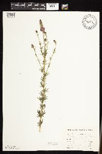 Dalea purpurea var. purpurea Ventenat 807626[1076046]Dorio, J. 3361977-06-23 United States, Minnesota, Benton, Benton Co. Englund Ecotone.;Englund Ecotone, The Nature Conservancy;037N;31W;, 45.694969 -94.149213 |
MIN:Plants | 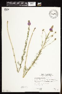 Dalea purpurea var. purpurea Ventenat 812672[1076044]Wheeler, Gerald 108041988-06-21 United States, Minnesota, Clay, Ca. 6 mi. WSW of Ulen; waterfowl area E off Rte. 27.;Flickertail Prairie Wildlife Management Area;141N;45W;3, 47.0568479 -96.374927 |
MIN:Plants | 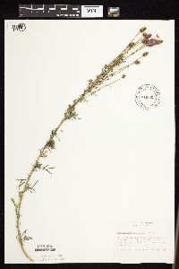 Dalea purpurea var. purpurea Ventenat 816395[1075991]Bender, J. s.n.1986-07-15 United States, Minnesota, Washington, Belwin Outdoor Education Laboratory, along roadside to the Druid Circle; T28N R20W Sec. 10;Belwin Outdoor Education Laboratory;028N;20W;10, 44.9271878 -92.7918522 |
MIN:Plants | 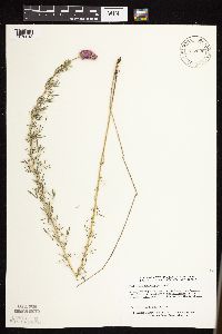 Dalea purpurea var. purpurea Ventenat 817696[1076043]Delaney, B. 891561989-08-09 United States, Minnesota, Isanti, 2.5 mi W of Cambridge, 0.5 mi S; NW1/4 SE1/4 Sec. 36 T36N R24W;;036N;24W;36, 45.5656077 -93.2758201 |
MIN:Plants |  Dalea purpurea var. purpurea Ventenat 830003[1076102]Townsend, D.; Cuthrell, Dave 91-2191991-07-14 United States, Minnesota, Marshall, Marshall Co.; SW1/4 SE1/4 SE1/4 Sec 3 T158N R46W;;158N;46W;3, 48.5364183 -96.573219 |
MIN:Plants |  Dalea purpurea var. purpurea Ventenat 834440[1076015]Myhre, K. 28381992-06-27 United States, Minnesota, Cass, Cass Co. Located 1 mi W of the Gull River; between the railroad tracks and hwy.210; T133N R29W NE1/4 of NW1/4 of sec.18;;133N;29W;18, 46.3332173 -94.3800167 |
MIN:Plants |  Dalea purpurea var. purpurea Ventenat 838311[1076016]Smith, Welby 177901990-08-07 United States, Minnesota, Red Lake, Marcoux Wildlife Management Area. Red Lake Co. In Marcoux State Wildlife Management Area, about 5 mi W-SW of Terrebonne; T150N R44W SE1/4 of NE1/4 of Sec Red Lake Co. In Marcoux State Wildlife Management Area, about 5 mi W-SW of Terrebonne; T150N R44W SE1/4 of NE1/4 of Sec.24. 150N 44W 24, 47.793335 -96.2258301 |
MIN:Plants |  Dalea purpurea var. purpurea Ventenat 92410[1076017]Butts, A. 341996-08-07 United States, Minnesota, Lyon, Camden State Park; Lyon Co. - Lyons Township. NW 1/4 of SE1/4, sect. 7, T110N R42W;Camden State Park;110N;42W;7, 44.3487268 -95.9476934 |
MIN:Plants |  Dalea purpurea Ventenat 294793[1075964]Benner, F.; Benner, J. 1261928-08-03 United States, Wisconsin, Polk, 7 mi N. St. Croix Falls, Wis. on River Road, E of road up ravine;Saint Croix National Riverway;;;, 45.481172 -92.687024 |
MIN:Plants |  Dalea purpurea Ventenat 331907[1122660]Hayward, Herman 5181926-08-18 United States, South Dakota, Fall River, Hot Springs - Edgemont Road |
MIN:Plants |  Dalea purpurea var. purpurea Ventenat 212360[1283022]Thayer, John 2014-09-02 United States, Minnesota, Itasca, UTM: E465023, N5277866.;Chippewa National Forest;47;39;11.7, 47.65325 -93.4657778 |
MIN:Plants |  Dalea purpurea Ventenat 954193[1295836]Stork, H.E. United States, Iowa, Johnson |
MIN:Plants |  Dalea purpurea Ventenat 954192[1295837]Harrington, Harold 81 United States, Iowa, Johnson |
MIN:Plants |  Dalea purpurea Ventenat 954191[1295838]Lampen, D. United States, Montana, Cascade |
MIN:Plants |  Dalea purpurea Ventenat 954190[1295839]Rogge, Janet 70 United States, South Dakota, Lincoln |
MIN:Plants |  Dalea purpurea Ventenat 954189[1295840]Rogge, Janet 70 United States, South Dakota, Lincoln |
MIN:Plants |  Dalea purpurea Ventenat 960983[1334063]Boyd, Crystal CLB2016242016-08-22 United States, Minnesota, Mahnomen, Santee Prairie SNA. 7 miles NE of Mahnomen. 3 miles east on St. Hwy 200. 4 miles north on 170th St. T145N R41W Sec. 7, 47.39377 -95.912 |
MIN:Plants |  Dalea purpurea Ventenat 965876[1356633] 1944-08-21 United States, South Dakota, Codington, Alkaline lake |
MIN:Plants |  911575[1078070]Smith, Welby 215391992-09-14 United States, Minnesota, Red Lake, Huot Wildlife Management Area. Red Lake County...Hout [sic] State Wildlife Management Area, about 6 miles west of Red Lake Falls...T 151N R 45W NW1/4 of SW1/4 of Sec 27. 151N 45W 27, 47.8702778 -96.415 |
MIN:Plants |  426915[1078111]DeMink, L. 4022000-09-17 United States, Minnesota, Morrison, Crane Meadows National Wildlife Refuge; SENE 30-T40N-R31W;Crane Meadows National Wildlife Refuge;040N;31W;30, 45.9338958 -94.2515644 |
MIN:Plants |  539933[1078079]Tester, John s.n.1957-07-04 United States, Minnesota, Mahnomen, 3-4 miles W and 1 mile S of Waubun;Waubun Prairie Wildlife Management Area / White Earth Indian Reservation;143N;42W;33, 47.1589 -96.00743 |
MIN:Plants |  140413[1078090]Sandberg, John s.n.1885-07-00 United States, Minnesota, Goodhue, Red Wing;;113N;14W;, 44.592792 -92.586673 |
MIN:Plants |  140414[1078136]Skinner, S. 1251902-06-17 United States, Minnesota, Cottonwood, Windom;;N;;, 43.874266 -95.12861 |
MIN:Plants |  140415[1078100]Nelson, N.L.T. 20641893-08-20 United States, Minnesota, Goodhue, Court House Lawn, Red Wing.;;113N;14W;, 44.562468 -92.533801 |
MIN:Plants |  140416[1078091]Aiton, G. s.n.1889-08-00 United States, Minnesota, [no further data];;;;, 46 -94 |
MIN:Plants |  140417[1122767]Sandberg, John s.n.1890-06-00 United States, Minnesota, Chisago, [no further data];;;;, 45.528143 -92.913635 |
Google Map
Google Maps is a web mapping service provided by Google that features a map that users can pan (by dragging the mouse) and zoom (by using the mouse wheel). Collection points are displayed as colored markers that when clicked on, displays the full information for that collection. When multiple species are queried (separated by semi-colons), different colored markers denote each individual species.