University of Minnesota
http://www.umn.edu/
612-625-5000
http://www.umn.edu/
612-625-5000
Minnesota Biodiversity Atlas
Bell Museum
Dataset: MIN-Plants
Taxa: Fabaceae
Search Criteria: excluding cultivated/captive occurrences
Bell Museum plants | |
 MIN:Plants | 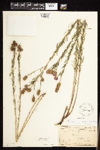 Dalea purpurea var. purpurea Ventenat 141810[1076076]Anderson, A. An7701893-08-00 United States, Minnesota, Goodhue, Featherstone;;N;;, 44.505469 -92.594345 |
MIN:Plants | 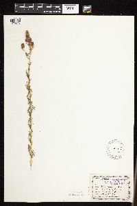 Dalea purpurea var. purpurea Ventenat 141812[1076049]Leonard, W. 311875-08-00 United States, Minnesota, Hennepin, City [Minneapolis];;N;;, 44.97025 -93.265896 |
MIN:Plants | 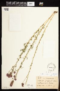 Dalea purpurea var. purpurea Ventenat 141814[1076183]Sheldon, Edmund S37161892-08-00 United States, Minnesota, Otter Tail, Fergus Falls;;N;;, 46.286099 -96.078588 |
MIN:Plants | 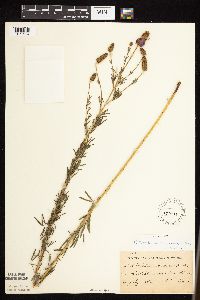 Dalea purpurea var. purpurea Ventenat 141815[1075994]Ballard, C. B10921892-07-00 United States, Minnesota, Nicollet, Nicollet;;109N;28W;, 44.2396867 -94.1904919 |
MIN:Plants | 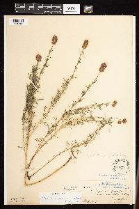 Dalea purpurea var. purpurea Ventenat 141817[1076066]Ballard, C. 31221907-08-13 United States, Minnesota, Clay, Muskoda [historic RR station near Hawley], Red River Valley;;139N;45W;17, 46.8545484 -96.3967683 |
MIN:Plants | 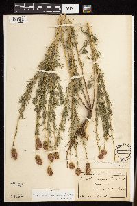 Dalea purpurea var. purpurea Ventenat 141818[1076080]Heller, A. s.n.1896-09-00 United States, Minnesota, Hennepin, Cedar Lake [other Heller colleciton indicated the one in Hennepin Co.];;029N;24W;00, 44.959994 -93.321462 |
MIN:Plants | 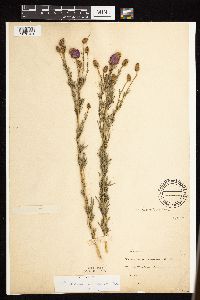 Dalea purpurea var. purpurea Ventenat 141819[1076124]Moyer, Lycurgus 21121885-07-17 United States, Minnesota, Winona, [no further data];;;;, 43.978945 -91.713211 |
MIN:Plants | 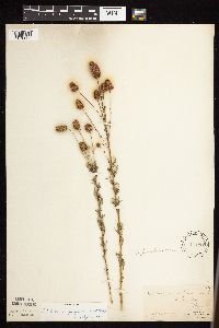 Dalea purpurea var. purpurea Ventenat 141820[1076036]Manning, Sara s.n.1883-07-28 United States, Minnesota, Wabasha, Lake City;;111N;12W;, 44.449412 -92.266844 |
MIN:Plants | 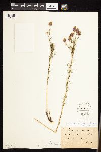 Dalea purpurea var. purpurea Ventenat 141821[1076087]Sheldon, Edmund S34031892-08-00 United States, Minnesota, Hubbard, Bottle Lake;;N;;, 47.035664 -94.938503 |
MIN:Plants | 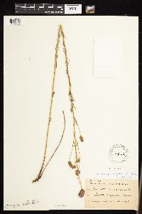 Dalea purpurea var. purpurea Ventenat 141822[1076089]Taylor, B. T15221892-08-00 United States, Minnesota, Chisago, North Branch;;N;;, 45.511352 -92.991204 |
MIN:Plants | 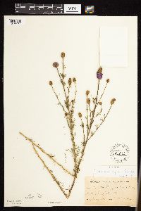 Dalea purpurea var. purpurea Ventenat 141823[1076079]Sheldon, Edmund S11271891-07-00 United States, Minnesota, Brown, Springfield;;N;;, 44.23688 -94.983033 |
MIN:Plants | 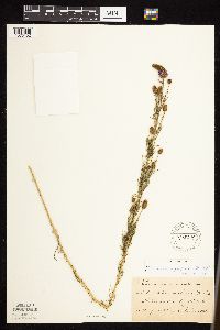 Dalea purpurea var. purpurea Ventenat 141824[1076152]Frost, W. F2951892-08-00 United States, Minnesota, Kandiyohi, Willmar;;N;;, 45.121908 -95.043342 |
MIN:Plants |  Dalea purpurea var. purpurea Ventenat 141825[1076088]Taylor, B. T8351891-07-00 United States, Minnesota, Pope, Glenwood;;N;;, 45.652639 -95.382892 |
MIN:Plants |  Dalea purpurea var. purpurea Ventenat 141826[1076086]Taylor, B. T1831891-06-00 United States, Minnesota, Waseca, Janesville;;N;;, 44.116078 -93.708004 |
MIN:Plants |  Dalea purpurea var. purpurea Ventenat 141827[1076184]Sheldon, Edmund S13721891-08-00 United States, Minnesota, Lincoln, Lake Benton;;109N;45W;, 44.24108 -96.26172 |
MIN:Plants |  Dalea purpurea var. purpurea Ventenat 141828[1076072]Sheldon, Edmund S9721891-07-00 United States, Minnesota, Brown, Sleepy Eye;;110N;32W;, 44.299394 -94.725867 |
MIN:Plants | 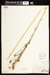 Dalea purpurea var. purpurea Ventenat 141829[1076071]Winchell, N. 42-61875-08-02 United States, Minnesota, Hennepin, Minneapolis;;N;;, 44.970736 -93.268643 |
MIN:Plants | 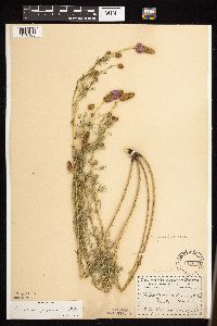 Dalea purpurea var. purpurea Ventenat 141830[1076185]Menzel, Max s.n1895-07-00 United States, Minnesota, Pipestone, Pipestone [assuming the quarry area; town generally noted as Pipestone City by collector];Pipestone National Monument;106N;46W;01, 44.01585 -96.31767 |
MIN:Plants | 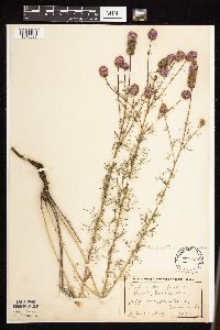 Dalea purpurea var. purpurea Ventenat 141831[1076035]Lyon, H. 2621899-07-20 United States, Minnesota, Houston, Jefferson;Dorer Memorial Hardwood State Forest;101N;04W;35, 43.50806 -91.28287 |
MIN:Plants | 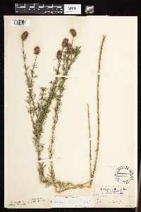 Dalea purpurea var. purpurea Ventenat 141833[1076053]Aiton, G. s.n.1892-09-00 United States, Minnesota, Hennepin, Minneapolis;;N;;, 44.970736 -93.268643 |
MIN:Plants | 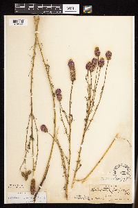 Dalea purpurea var. purpurea Ventenat 141834[1076055]Nelson, N.L.T. 67571899-08-00 United States, Minnesota, Goodhue, [no further data];;;;, 44.404993 -92.677429 |
MIN:Plants | 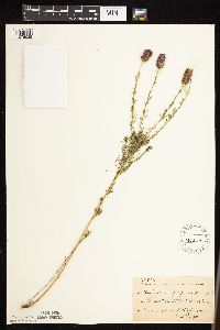 Dalea purpurea var. purpurea Ventenat 141837[1076029]Sheldon, Edmund; et al. S38061892-08-00 United States, Minnesota, Otter Tail, Pelican Lake, O.T. Co.;;;;, 46.699403 -96.02061 |
MIN:Plants | 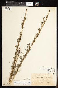 Dalea purpurea var. purpurea Ventenat 141838[1076054]Taylor, B. T6831891-07-00 United States, Minnesota, Faribault, Minnesota Lake;;N;;, 43.8406168 -93.7180717 |
MIN:Plants | 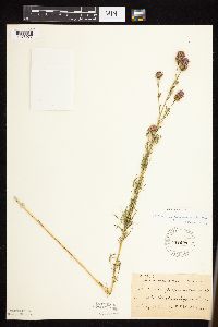 Dalea purpurea var. purpurea Ventenat 141839[1076077]Sheldon, Edmund S34531892-08-00 United States, Minnesota, Douglas, Lake Christina;;N;;, 46.090549 -95.736412 |
MIN:Plants | 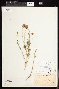 Dalea purpurea var. purpurea Ventenat 141840[1076167]Kassube, J. s.n.1878-08-00 United States, Minnesota, Hennepin, Minneapolis;;N;;, 44.970736 -93.268643 |
MIN:Plants |  Dalea purpurea var. purpurea Ventenat 141841[1076168]Moyer, Lycurgus s.n.1896-08-08 United States, Minnesota, Chippewa, Montevideo;;117N;40W;, 44.953148 -95.715397 |
MIN:Plants | 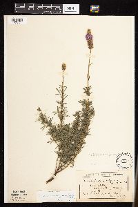 Dalea purpurea var. purpurea Ventenat 141842[1076171]Ballard, C. 26101900-08-00 United States, Minnesota, Kittson, Humboldt.;;163N;50W;, 48.921096 -97.093393 |
MIN:Plants |  Dalea purpurea var. purpurea Ventenat 141843[1076169]Ballard, C. 27651900-08-00 United States, Minnesota, Kittson, Hallock, Kittson Co.;;161N;49W;, 48.774426 -96.943357 |
MIN:Plants | 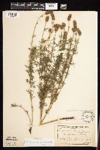 Dalea purpurea var. purpurea Ventenat 141844[1076037]MacMillan, C.; et al. 62Sk1900-08-00 United States, Minnesota, Polk, Crookston;;150N;46W;30, 47.782 -96.60007 |
MIN:Plants | 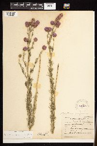 Dalea purpurea var. purpurea Ventenat 226220[1076189]Roberts, Thomas s.n.1904-08-15 United States, Minnesota, Wabasha, Wabasha Co.;;;;, 44.28333 -92.21667 |
MIN:Plants | 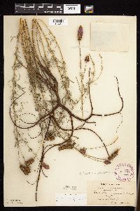 Dalea purpurea var. purpurea Ventenat 264567[1076051]White, Sidney s.n.1890-06-00 United States, Minnesota, Winona, Winona Co.;;N;;, 43.978945 -91.713211 |
MIN:Plants | 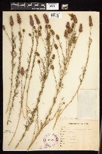 Dalea purpurea var. purpurea Ventenat 265476[1076129]Goldsmith, G. G1021912-00-00 United States, Minnesota, Rice, Northfield;;N;;, 44.4496671 -93.1708471 |
MIN:Plants | 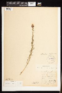 Dalea purpurea var. purpurea Ventenat 270052[1076130]Wheeler, William 691893-07-00 United States, Minnesota, Houston, Winnebago Valley;Dorer Memorial Hardwood State Forest;N;;, 43.539205 -91.384455 |
MIN:Plants | 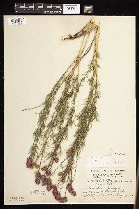 Dalea purpurea var. purpurea Ventenat 276064[1076075]Grant, Martin 30781929-08-13 United States, Minnesota, Becker, Itasca Park. Becker Co. De Soto Lake. NE1/4 NE1/4 Sec. 3, T142N, R36W.;Itasca State Park;142N;36W;3, 47.145259 -95.2227848 |
MIN:Plants | 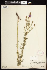 Dalea purpurea var. purpurea Ventenat 277671[1076068]Hotchkiss, N.; et al. 3181930-07-21 United States, Minnesota, Cottonwood, Near Delft. Cottonwood Co.;;;;, 43.986346 -95.08888 |
MIN:Plants | 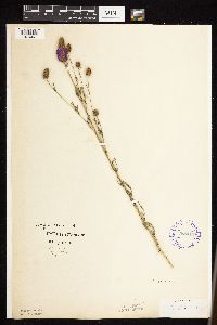 Dalea purpurea var. purpurea Ventenat 288413[1076067]Johnson, R. s.n.1914-07-03 United States, Minnesota, Ramsey, St. Paul;;;;, 44.957171 -93.092163 |
MIN:Plants | 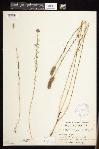 Dalea purpurea var. purpurea Ventenat 332531[1076074]Grant, Martin 67781935-09-06 United States, Minnesota, Clearwater, Itasca Park. Squaw Lake. SE1/4 SE1/4 Sec. 5, T143N, R36W.;Itasca State Park;143N;36W;5, 47.2314256 -95.2657843 |
MIN:Plants | 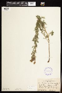 Dalea purpurea var. purpurea Ventenat 352719[1076186]Jukkola, E. 751937-07-23 United States, Minnesota, Hennepin, East River Road, S of Botany Building, Minneapolis.;;N;;, 44.98395 -93.25285 |
MIN:Plants |  Dalea purpurea var. purpurea Ventenat 353980[1076188]Lakela, Olga 26661938-08-04 United States, Minnesota, Saint Louis, Chester Park Hill near the jct. of Skyline Parkway and Kenwood, Duluth.;;050N;14W;, 46.805898 -92.1005 |
MIN:Plants |  Dalea purpurea var. purpurea Ventenat 354586[1076187]Moyle, J. 13161934-07-18 United States, Minnesota, Pennington, 9 mi. S of Thief River Falls;;N;;, 47.989428 -96.180888 |
MIN:Plants |  Dalea purpurea var. purpurea Ventenat 370993[1076023]Moore, John; Moore, Marjorie 135591940-09-12 United States, Minnesota, Washington, Washington Co.; 4.5 mi south of Afton;;027N;20W;, 44.837578 -92.783537 |
MIN:Plants |  Dalea purpurea var. purpurea Ventenat 371336[1076081]Moore, John; et al. 146441941-07-06 United States, Minnesota, Pope, 1 mi. E of Glenwood. Pope Co.;;;;, 45.646721 -95.345661 |
MIN:Plants | 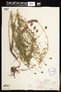 Dalea purpurea var. purpurea Ventenat 371515[1075996]Moore, John; et al. 149371941-08-06 United States, Minnesota, Isanti, Along Rum River, 1/2 mi N of West Point. Isanti Co.;;;;, 45.564436 -93.387672 |
MIN:Plants | 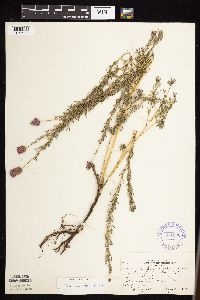 Dalea purpurea var. purpurea Ventenat 371530[1075977]Moore, John; et al. 149301941-08-06 United States, Minnesota, Sherburne, N shore of Lake Fremont, 1.5 mi N fo Zimmerman. Sherburne Co.;;;;, 45.465199 -93.574113 |
MIN:Plants | 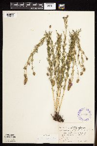 Dalea purpurea var. purpurea Ventenat 372516[1075995]Moore, John; et al. 147441941-07-06 United States, Minnesota, Otter Tail, Slope of Inspiration Peak. Otter Tail Co.;Inspiration Peak Scenic Wayside Park;131N;39W;22, 46.1442542 -95.5735436 |
MIN:Plants | 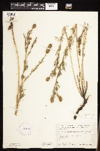 Dalea purpurea var. purpurea Ventenat 412003[1076139]Moore, John; Moore, Marjorie 115551939-08-08 United States, Minnesota, Kittson, 1 mi. N of Northcote;;N;;, 48.859733 -97.001169 |
MIN:Plants | 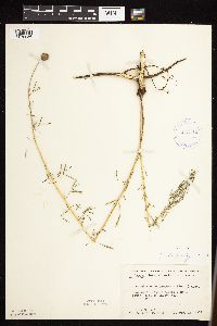 Dalea purpurea var. purpurea Ventenat 413142[1076056]Moore, John; Moore, Marjorie 118061939-08-16 United States, Minnesota, Koochiching, Koochiching Co.; 1 mi. SE of Tilson Bay, Rainy Lake. 1 mi. SE of Tilson Bay, Rainy Lake.. 071N 22W , 48.596916 -93.206081 |
MIN:Plants | 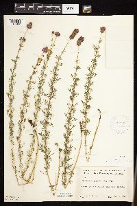 Dalea purpurea var. purpurea Ventenat 421362[1076052]Jacobs, D. 5341948-08-11 United States, Minnesota, Blue Earth, Sibley Park, Mankato;;N;;, 44.1608 -94.032178 |
MIN:Plants | 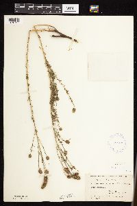 Dalea purpurea var. purpurea Ventenat 424193[1076137]Fassett, N.; et al. 44391927-08-26 United States, Minnesota, Wabasha, Kellogg;;;;, 44.30827 -91.997179 |
MIN:Plants | 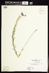 Dalea purpurea var. purpurea Ventenat 427384[1076103]Woodward, D. 111995-07-06 United States, Minnesota, Mahnomen, Waubon [sic] prairie. Approximately 3 miles west of town of Waubon [sic];Waubun Prairie Wildlife Management Area / White Earth Indian Reservation;143N;42W;, 47.315221 -96.032708 |
MIN:Plants |  Dalea purpurea var. purpurea Ventenat 427807[1076164]Jones, George Neville 186351946-08-05 United States, Minnesota, Saint Louis, Ely;;N;;, 47.905769 -91.849921 |
MIN:Plants |  Dalea purpurea var. purpurea Ventenat 429533[1076014]Smith, Welby 208661992-07-15 United States, Minnesota, Marshall, Marshall Co.; About 9 miles south-southwest of Strandquist; T 156N R 46W SW1/4 of SE1/4 of Sec 1;;156N;46W;1, 48.3572235 -96.5080566 |
MIN:Plants |  Dalea purpurea var. purpurea Ventenat 441997[1076165]Moore, John; et al. 182321945-09-05 United States, Minnesota, Kittson, 1 mi NW of Halma;;;;, 48.671321 -96.615813 |
MIN:Plants |  Dalea purpurea var. purpurea Ventenat 442140[1076161]Moore, John; Huff, N. 190481946-08-16 United States, Minnesota, Stevens, Pomme De Terre State Recreational Reserve;;;;, 45.581153 -95.881489 |
MIN:Plants | 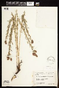 Dalea purpurea var. purpurea Ventenat 444753[1075989]Moore, John; Huff, N. 197281947-08-08 United States, Minnesota, Morrison, Prairie at Little Falls;;N;;, 45.960127 -94.393058 |
MIN:Plants | 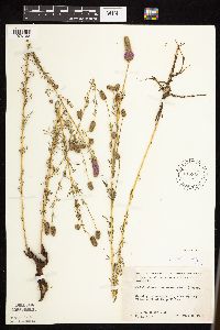 Dalea purpurea var. purpurea Ventenat 445859[1076163]Moore, John; Huff, N. 180401945-07-26 United States, Minnesota, Morrison, E of the river E of Camp Ripley;;N;;, 46.210507 -94.383351 |
MIN:Plants | 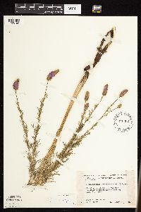 Dalea purpurea var. purpurea Ventenat 446302[1076162]Moore, John; Huff, N. 187911946-07-31 United States, Minnesota, Benton, Along the roadside 5 mi NE of East St. Cloud;;N;;, 45.630769 -94.093666 |
MIN:Plants | 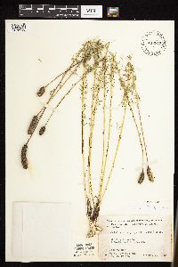 Dalea purpurea var. purpurea Ventenat 448342[1075990]Moore, John; et al. 193111946-09-20 United States, Minnesota, McLeod, 2 mi E of Stewart. McLeod Co.;;;;, 44.724677 -94.445053 |
MIN:Plants | 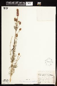 Dalea purpurea var. purpurea Ventenat 458063[1076170]Garrison, O. 1151879-07-23 United States, Minnesota, Stearns, Near St. Cloud;;N;;, 45.5582 -94.181183 |
MIN:Plants | 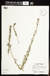 Dalea purpurea var. purpurea Ventenat 460119[1076030]Myhre, K. 23631992-06-22 United States, Minnesota, Cass, Cass County...located 1 mile west of the Gull River in a narrow, flat strip between the railroad tracks and highway 210...T 133N R 29W NE1/4 of NW1/4 of Sec 18. 133N 29W 18, 46.3332173 -94.3800167 |
MIN:Plants | 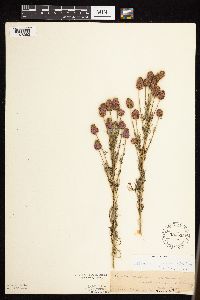 Dalea purpurea var. purpurea Ventenat 524565[1076063]Twing, H. s.n.1891-07-29 United States, Minnesota, Hennepin, Near Ft. Snelling, Minneapolis.;Fort Snelling Military Reservation;N;;, 44.891721 -93.181782 |
MIN:Plants | 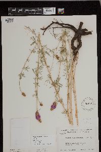 Dalea purpurea var. purpurea Ventenat 526333[1075978]Moore, John 211841951-08-07 United States, Minnesota, Wilkin, 9 mi. NE of Manston;;N;;, 46.505625 -96.43956 |
MIN:Plants | 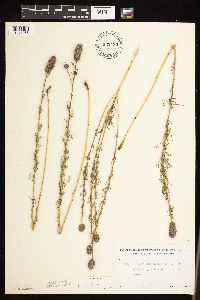 Dalea purpurea var. purpurea Ventenat 532430[1076065]Lakela, Olga 209311956-08-22 United States, Minnesota, Saint Louis, Railway grade at Payne, Hwy. 7;;N;;, 47.09675 -92.602791 |
MIN:Plants | 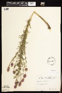 Dalea purpurea var. purpurea Ventenat 541397[1076166]Scharf, J. s.n.1956-08-09 United States, Minnesota, Pipestone, Pipestone Co.; Holland Marsh, 1 mile east of Holland [Holland WMA?];Holland Wildlife Management Area;107N;44W;00, 44.097318 -96.162324 |
MIN:Plants | 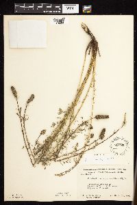 Dalea purpurea var. purpurea Ventenat 549782[1076064]Moore, John; et al. 223431954-09-23 United States, Minnesota, Pipestone, Pipestone County...Pipestone National Monument, Pipestone;Pipestone National Monument;106N;46W;01, 44.0158476 -96.3176691 |
MIN:Plants | 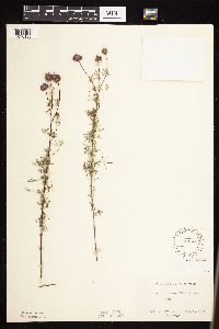 Dalea purpurea var. purpurea Ventenat 551165[1076133]Cotter, Shirley 6621948-08-21 United States, Minnesota, Becker, De Soto Lake, Itasca Park;Itasca State Park;142N;36W;, 47.145723 -95.222736 |
MIN:Plants | 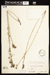 Dalea purpurea var. purpurea Ventenat 552312[1076142]Cooper, William s.n.1929-09-13 United States, Minnesota, Crow Wing, Brainerd;;N;;, 46.356837 -94.195679 |
MIN:Plants | 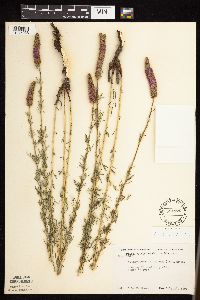 Dalea purpurea var. purpurea Ventenat 554176[1075988]Moore, John 226191955-07-26 United States, Minnesota, Norman, 1/2 mi S of Syre;;N;;, 47.173002 -96.258671 |
MIN:Plants | 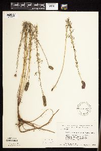 Dalea purpurea var. purpurea Ventenat 558547[1075997]Moore, John; Moore, Marjorie 235891957-09-19 United States, Minnesota, Isanti, Edge of old field, N of the Cornea House.;Cedar Creek National History Area;034N;23W;, 45.429552 -93.184968 |
MIN:Plants | 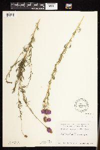 Dalea purpurea var. purpurea Ventenat 561408[1076140]Ovington, John s.n.1959-07-25 United States, Minnesota, Anoka, Cedar Creek Natural History Area.;Cedar Creek National History Area;034N;23W;, 45.409155 -93.198444 |
MIN:Plants | 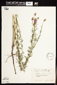 Dalea purpurea var. purpurea Ventenat 568783[1076034]Moore, John 252131960-08-12 United States, Minnesota, Anoka, S of farmsted S side of Fish Lake;Cedar Creek National History Area;034N;23W;, 45.392237 -93.168622 |
MIN:Plants | 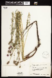 Dalea purpurea var. purpurea Ventenat 572658[1076141]Moore, John; et al. 257601961-08-17 United States, Minnesota, Martin, Martin County...Trimont Prairie; SE1/4 Sec. 9 T103N R32W;;103N;32W;09, 43.7398725 -94.6846948 |
MIN:Plants | 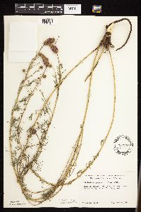 Dalea purpurea var. purpurea Ventenat 584729[1076131]Morean, Edith s.n.1961-06-18 United States, Minnesota, Pine, Pine Co. S of Hinckley. Disturbed area near the intersection of Hwy. 23 and 61.;;041N;21W;, 45.976838 -92.950219 |
MIN:Plants | 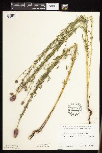 Dalea purpurea var. purpurea Ventenat 590157[1076062]Meierotto, R. s.n.1962-08-15 United States, Minnesota, Mahnomen, Mahnomen Co. Waubun Prairie: Sec. 33, T143N, R42W;Waubun Prairie Wildlife Management Area / White Earth Indian Reservation;143N;42W;33, 47.1589041 -96.0074302 |
MIN:Plants | 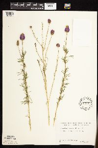 Dalea purpurea var. purpurea Ventenat 592205[1076146]Westkaemper, Remberta s.n.1962-07-00 United States, Minnesota, Stearns, Stearns Co. St. Joseph, along rr tracks;;124N;29W;, 45.543642 -94.322053 |
MIN:Plants | 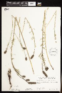 Dalea purpurea var. purpurea Ventenat 619843[1076018]Ownbey, Gerald 43501970-09-06 United States, Minnesota, Washington, 2.5 mi. N of Afton, Rte. 95.;;028N;20W;, 44.938949 -92.783537 |
MIN:Plants | 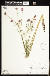 Dalea purpurea var. purpurea Ventenat 628109[1076145]Ownbey, Gerald 46811972-08-18 United States, Minnesota, Mahnomen, Mahnomen Co. Rt. 200, 9.0 mi E of its jnc with rt. 59, Mahnomen, S of hwy, near Perch Lake;White Earth Indian Reservation;144N;40W;, 47.32233 -95.775449 |
MIN:Plants | 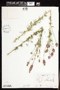 Dalea purpurea var. purpurea Ventenat 635058[1076022]Lindayen, T. 1271972-08-01 United States, Minnesota, Washington, T30N, R21W, SE1/4 of Sec. 14. 5.3 mi. due E of Hwy. 96 from Jct. of 96 and 244.;;030N;21W;14, 45.0867623 -92.8936205 |
MIN:Plants |  Dalea purpurea var. purpurea Ventenat 669706[1076006]Wheeler, Gerald s.n.1974-07-02 United States, Minnesota, Meeker, Sioux Lake, 8 mi SSE of Litchfield, 2 mi E of hwy 22, ca. 1/8 mi W of the lake;;N;;, 45.019257 -94.467114 |
MIN:Plants |  Dalea purpurea var. purpurea Ventenat 670652[1075979]Heitlinger, M. 3061971-07-19 United States, Minnesota, McLeod, Schaefer Prairie, ca. midway along prominent ridge; SE1/4 Sec. 34 T115N R29W;Schaefer Prairie, The Nature Conservancy;115N;29W;34, 44.7250496 -94.3049103 |
MIN:Plants |  Dalea purpurea var. purpurea Ventenat 673586[1076147]Borchard, Alma s.n.1937-07-31 United States, Minnesota, Hennepin, Fort Snelling;Fort Snelling Military Reservation;N;;, 44.8881 -93.19029 |
MIN:Plants |  Dalea purpurea var. purpurea Ventenat 685106[1076005]Stassen, Carol 1531977-06-27 United States, Minnesota, Lyon, Camden State Park; T110N R42W Sec. 5 SE1/4;Camden State Park;110N;42W;5, 44.3631806 -95.9274434 |
MIN:Plants | 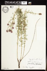 Dalea purpurea var. purpurea Ventenat 689969[1076047]Ownbey, Gerald 56571977-07-19 United States, Minnesota, Hubbard, E side of Rte. 71, 2.5 mi. S of it's jct. with Rte. 34 in Park Rapids. Adjacent to the hwy.;;N;;, 46.885521 -95.060692 |
MIN:Plants | 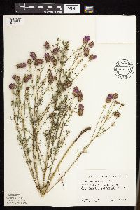 Dalea purpurea var. purpurea Ventenat 689977[1076039]Ownbey, Gerald 57541977-08-05 United States, Minnesota, Polk, Minn. rte 92, 0.6 mi NW of its jnc with co. rte 2 at Gully; T150N R39W Sec. 34 NW1/4;;T150N R39W S34, 47.768499 -95.633532 |
MIN:Plants | 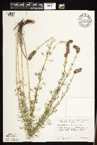 Dalea purpurea var. purpurea Ventenat 690003[1076040]Ownbey, Gerald 57291977-07-27 United States, Minnesota, Norman, Near Minn. rte 113, 3.5 mi E, 0.3 mi N of Syre, NE of a lake;;143N;43W;19, 47.1875042 -96.1839929 |
MIN:Plants | 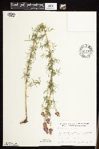 Dalea purpurea var. purpurea Ventenat 690509[1076045]Siemers, Ross 491977-06-28 United States, Minnesota, Stearns, Stearns Co. Great Blue Heron Rookery Area. Observation Hill. T123N, R30W, Sec. 13.;Cold Spring Heron Colony Scientific Natural Area;123N;30W;13, 45.463971 -94.3943224 |
MIN:Plants | 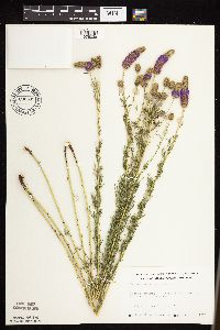 Dalea purpurea var. purpurea Ventenat 690599[1076038]Siemers, Ross 701977-07-13 United States, Minnesota, Stearns, Stearns Co. Roscoe Prairie, 2 mi SW of Roscoe on hwy 16; T123N R32W Sec. 35;Roscoe Prairie Scientific Natural Area;123N;32W;35, 45.4195202 -94.6709243 |
MIN:Plants | 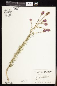 Dalea purpurea var. purpurea Ventenat 696584[1076048]Smith, Welby 6481978-07-28 United States, Minnesota, Wright, Wright Co.; T122N, R25W, N1/2 Sec. 32. Between Co. Rd. 75, and Burlington tracks. Ca. 3 mi. from Monticello.;;122N;25W;32, 45.3319075 -93.8600014 |
MIN:Plants | 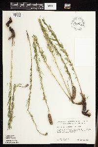 Dalea purpurea var. purpurea Ventenat 697825[1076144]Ownbey, Gerald 52861976-08-12 United States, Minnesota, Polk, 2.4 mi SE of Fosston, U.S. rte no. 2, located between E and W bound lanes of the hwy;;N;;, 47.555717 -95.710539 |
MIN:Plants | 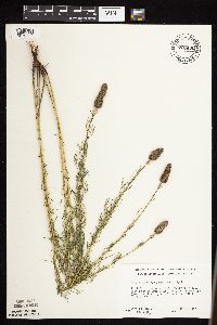 Dalea purpurea var. purpurea Ventenat 700430[1076000]Ownbey, Gerald 61601978-08-15 United States, Minnesota, Houston, Houston Co. Near crest of precipitous slope at jnc of St. rte 249 and co. rte 32; T102N R5W NW1/4 Sec. 22 Mayville Twp.;Dorer Memorial Hardwood State Forest;102N;05W;22, 43.6232853 -91.4223316 |
MIN:Plants | 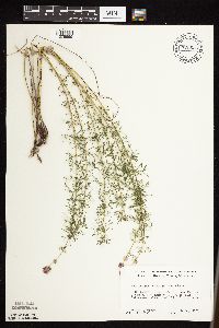 Dalea purpurea var. purpurea Ventenat 700526[1075999]Ownbey, Gerald 61301978-08-14 United States, Minnesota, Houston, Houston Co. U.S. rte 16, 3.7 mi W of cemetery, W side Hokah, along W end of bluff; T104N R5W W1/2 Sec. 34;;104N;05W;34, 43.7677422 -91.4228103 |
MIN:Plants | 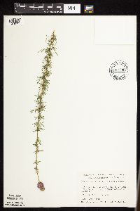 Dalea purpurea var. purpurea Ventenat 701068[1076001]Dorio, J. 4391977-07-06 United States, Minnesota, Morrison, Ripley Esker, ca. 3 mi NE of Camp Ripley Junction; T42N R31W Sec. 19;Ripley Esker Scientific Natural Area;042N;31W;19, 46.1062834 -94.30299 |
MIN:Plants | 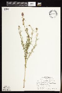 Dalea purpurea var. purpurea Ventenat 701375[1076002]Dorio, J. 3851977-06-28 United States, Minnesota, Morrison, Co.: Morrison ... Sandhill Crane Meadow, 4.5 mi W of Buckman on hwy 34 ... T39N R31W Sec. 3 and 4;Crane Meadows National Wildlife Refuge;039N;31W;, 45.904403 -94.1885788 |
MIN:Plants | 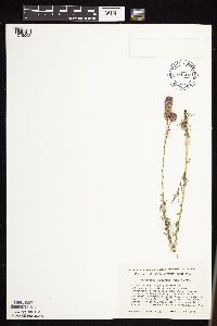 Dalea purpurea var. purpurea Ventenat 704668[1076003]Smith, Welby 17201979-08-16 United States, Minnesota, Wabasha, 400 meters due E of co. rd 84; T109N R9W SW1/4 NE1/4 Sec. 18;;109N;09W;18, 44.243599 -91.9391115 |
MIN:Plants | 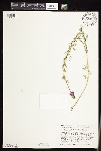 Dalea purpurea var. purpurea Ventenat 707966[1076118]Smith, Welby 12851979-08-03 United States, Minnesota, Douglas, T127N, R40W, NW1/4 NE1/4 Sec. 18. 3 mi. NW of Kensington.;;127N;40W;18, 45.816134 -95.746813 |
MIN:Plants | 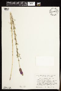 Dalea purpurea var. purpurea Ventenat 707971[1076119]Smith, Welby 12901979-08-03 United States, Minnesota, Pope, T125N R38W, NW1/4 NW1/4 Sec. 6. "Strandness Prairie". 6 mi. W and 1 mi. N of jct. of Hwy. 29 and 104 in Glenwood.;Strandness Prairie, The Nature Conservancy;125N;38W;6, 45.6651515 -95.5001117 |
MIN:Plants | 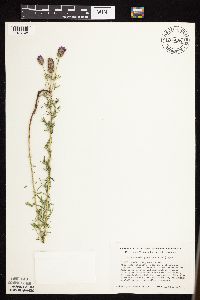 Dalea purpurea var. purpurea Ventenat 708085[1076148]Smith, Welby 14281979-08-21 United States, Minnesota, Wilkin, Foxhome Prairie, 9 mi S of Rothsay; T133N R45W NE1/4 Sec. 24;Foxhome Prairie, The Nature Conservancy;133N;45W;24, 46.3186527 -96.2907137 |
MIN:Plants | 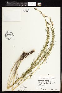 Dalea purpurea var. purpurea Ventenat 709185[1076050]Wheeler, Gerald 41751979-07-05 United States, Minnesota, Houston, Houston Co. Ca. 5.5 mi SSW of Reno, adjacent to Rt.5; T101N R4W Sec. 28;Dorer Memorial Hardwood State Forest;101N;04W;28, 43.5224424 -91.3224989 |
MIN:Plants | 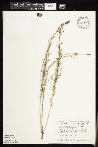 Dalea purpurea var. purpurea Ventenat 709336[1075971]Wheeler, Gerald 43281979-07-10 United States, Minnesota, Lac Qui Parle, Ca. 1 mi E of Nassau on rte 24, near the jnc of rte 7 and 24; T119N R46W Sec. 33;;119N;46W;33, 45.0734795 -96.4248474 |
MIN:Plants | 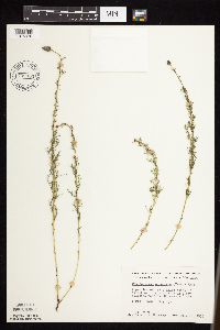 Dalea purpurea var. purpurea Ventenat 709354[1075970]Wheeler, Gerald 43461979-07-10 United States, Minnesota, Lac Qui Parle, Ca. 17.5 mi N of Marietta, near the Minnesota River; T121N R46W Sec. 27;;121N;46W;27, 45.2608089 -96.4232441 |
Google Map
Google Maps is a web mapping service provided by Google that features a map that users can pan (by dragging the mouse) and zoom (by using the mouse wheel). Collection points are displayed as colored markers that when clicked on, displays the full information for that collection. When multiple species are queried (separated by semi-colons), different colored markers denote each individual species.