University of Minnesota
http://www.umn.edu/
612-625-5000
http://www.umn.edu/
612-625-5000
Minnesota Biodiversity Atlas
Bell Museum
Dataset: MIN-Plants
Taxa: Quercus
Search Criteria: excluding cultivated/captive occurrences
Bell Museum plants | |
 MIN:Plants | 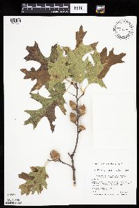 Quercus ellipsoidalis E.J. Hill 462287[1004804]Smith, Welby 255511994-09-15 United States, Minnesota, Winona, Whitewater Wildlife Management Area. Winona County ... Whitewater State Wildlife Management Area, about 5 miles southwest of Weaver ... T108N R10W NE1/4 SW1/4 of Sec 14. 108N 10W 14, 44.1555556 -91.9952778 |
MIN:Plants | 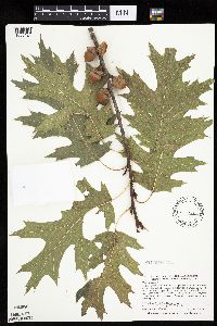 477158[1005424]Smith, Welby 290642000-08-31 United States, Minnesota, Anoka, Carlos Avery Wildlife Management Area. Anoka County ... Carlos Avery State Wildlife Management area. On the west side of Linwood lake, about 4.5 miles west of Wyoming (town) ... T 33N R 22W SE1/4 of NW1/4 of Sec 16. 033N 22W 16, 45.3491667 -93.0969444 |
MIN:Plants | 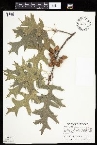 Quercus ellipsoidalis E.J. Hill 456137[1004877]Smith, Welby 290222000-08-22 United States, Minnesota, Pine, Pine County ... St. Croix State Park; where Sand Creek joins the St. Croix River ... T40N R18W SE1/4 of SW1/4 of Sec 19;Saint Croix State Park;040N;18W;19, 45.9322205 -92.6399994 |
MIN:Plants | 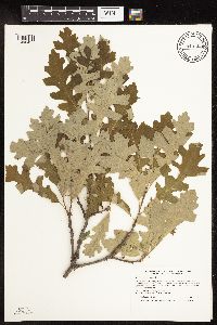 Quercus macrocarpa Michaux 913508[1096457]Smith, Welby 242671994-07-02 United States, Minnesota, Polk, On Nancy Sather's farm, about 1.25 miles west of Polk-Clearwater County line. NE1/4 of SE1/4 of Sec;;147N;39W;11, 47.5633333 -95.5802778 |
MIN:Plants | 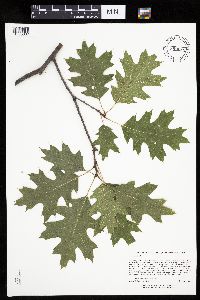 899086[1005387]Lee, Michael MDL41382005-08-31 United States, Minnesota, Otter Tail, Sonnenberg Wildlife Management Area. OTTER TAIL COUNTY...Sonnenberg State Wildlife Management Area...1.5 miles north-northeast of Vergas ...T137N R40W NW1/4 of SW1/4 Sec.18. 137N 40W 18, 46.67988 -95.78411 |
MIN:Plants | 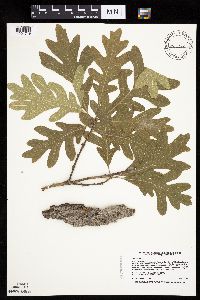 506914[1004719]Smith, Welby 222981993-06-03 United States, Minnesota, Sibley, Vale Wildlife Management Area. Sibley County ... Vale State Wildlife Management Area; in the valley of High Island Creek, about 2.5 miles southwest of its confluence with the Minnesota River ... T 113N R 26W NE1/4 of SW1/4 of sec 27. 113N 26W 27, 44.5625 -93.9427795 |
MIN:Plants | 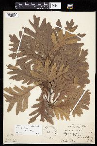 Quercus alba L. 226008[1004652]Rydberg, P.; Rosendahl, C. s.n.1926-09-15 United States, Minnesota, Washington, Pine Tree Lake, near Mahtomedi. ;;030N;21W;, 45.10111 -92.95278 |
MIN:Plants | 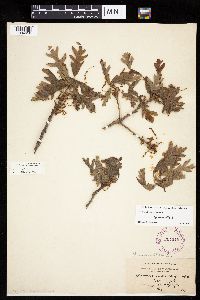 Quercus alba L. 264245[1004658]Holzinger, John s.n.1897-05-00 United States, Minnesota, Winona, Bear Creek. Winona Co.;;;;, 44.07528 -91.84667 |
MIN:Plants |  Quercus alba L. 264249[1004667]Holzinger, John s.n.1901-08-00 United States, Minnesota, Winona, Laird's Spring. Winona Co.;;;;, 43.96667 -91.76667 |
MIN:Plants |  Quercus alba L. 288142[1096386]Meck, Carlton s.n.1914-05-15 United States, Minnesota, Ramsey, St. Anthony Park [St. Paul neighborhood near U of M];;029N;23W;, 44.99208 -93.16639 |
MIN:Plants |  Quercus alba L. 293442[1004703]Nielsen, E. 29421934-09-30 United States, Minnesota, Anoka, Near Decodon Bog.;Cedar Creek National History Area;034N;23W;, 45.405014 -93.206388 |
MIN:Plants |  Quercus alba L. 349297[1004700]Dyal, S.; et al. 28411934-08-26 United States, Minnesota, Hennepin, 1 mi. S of the Minnesota River Valley. On Cedar Ave, Minneapolis.;;;;, 44.96552 -93.26361 |
MIN:Plants | 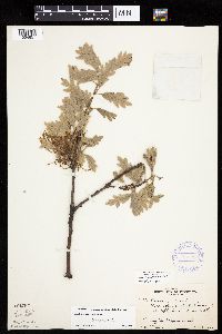 Quercus alba L. 352216[1004657]Nielsen, E. 18731933-05-20 United States, Minnesota, Ramsey, Battle Creek Parks, Ramsey Co.;Battle Creek County Park;028N;22W;00, 44.92667 -93.02889 |
MIN:Plants | 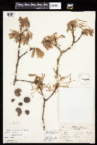 Quercus alba L. 370248[1004659]Moore, John 138321941-05-10 United States, Minnesota, Olmsted, E side of the road, 2 1/4 mi. S of Marion. Pleasant Grove Twp.;Dorer Memorial Hardwood State Forest;105N;13W;, 43.88567 -92.34806 |
MIN:Plants | 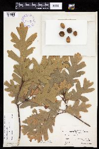 Quercus alba L. 375536[1004707]Butters, F.; Moore, John 152111941-10-06 United States, Minnesota, Chisago, Taylors Falls;;034N;19W;, 45.40194 -92.65222 |
MIN:Plants | 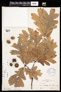 Quercus alba L. 375540[1004671]Moore, John 152151941-10-10 United States, Minnesota, Dakota, Kaposia Park, South St. Paul.;;028N;22W;, 44.90639 -93.06194 |
MIN:Plants |  Quercus alba L. 381088[1004708]Moore, John 15681942-09-10 United States, Minnesota, Washington, Washington Co.; North bank of Long Lake, Mahtomedi.;;030N;21W;, 45.0775 -92.94778 |
MIN:Plants |  Quercus alba L. 383680[1004662]Moore, John 160031943-08-24 United States, Minnesota, Fillmore, 2 mi. up the Root River from Peterson.;;;;, 43.78639 -91.83472 |
MIN:Plants |  Quercus alba L. 373986[1004704]Linnaean Club, U of M, 881939-05-21 United States, Minnesota, Rice, [no further data];Nerstrand Woods State Park;110N;19W;, 44.342646 -93.10644 |
MIN:Plants |  Quercus alba L. 448527[1004655]Moore, John; Huff, N. 181041945-08-03 United States, Minnesota, Pine, Near the fire tower, 7 mi. W of the headwuarters, St. Croix St. Park.;Saint Croix State Park;;;, 45.939717 -92.721467 |
MIN:Plants |  Quercus alba L. 475844[1004672]Smith, Welby 152181989-05-31 United States, Minnesota, Freeborn, Carex Wildlife Management Area. Freeborn County...'Carex' State Wildlife Management Area, about 7 miles east-southeast of Hollandale; NW1/4 NW1/4 section 23, T 103N R 19W. 103N 19W 23, 43.7155556 -93.0866667 |
MIN:Plants |  Quercus alba L. 494329[1004706]Huff, N. s.n.1941-10-04 United States, Minnesota, Morrison, Twin Lakes, Sec. 16, Pike Creek Twp. 5 mi. W of Little Falls.;;129N;30W;, 45.97634 -94.46639 |
MIN:Plants |  Quercus alba L. 494330[1004647]Huff, N. s.n.1941-05-09 United States, Minnesota, Morrison, Twin Lakes. Sec. 16. Pike Creek [Twp.]. 5 mi. W of Little Falls.;;129N;30W;16, 45.97634 -94.46639 |
MIN:Plants |  Quercus alba L. 494331[1004653]Huff, N. s.n.1941-10-04 United States, Minnesota, Morrison, Near Highway, 6 to 7 mi. drive N from Randall. Clough Twp.;;131N;30W;, 46.18649 -94.50851 |
MIN:Plants |  Quercus alba L. 542393[1004663]Moore, John 213871951-10-09 United States, Minnesota, Steele, Along the N shore of Rice Lake, Havana Twp.;Rice Lake State Park;107N;19W;, 44.08783 -93.05901 |
MIN:Plants |  Quercus x bebbiana C.K. Schneider 547869[1004728]Huff, N. s.n.1941-08-24 United States, Minnesota, Sherburne, Zimmerman;;;;, 45.4439 -93.5908 |
MIN:Plants |  Quercus alba L. 568394[1096385]Archer, A. s.n.1960-08-19 United States, Minnesota, Anoka, Stand 4-60;Cedar Creek National History Area;034N;23W;, 45.4280632 -93.2039968 |
MIN:Plants |  Quercus alba L. 568395[1096383]Archer, A. s.n.1960-09-01 United States, Minnesota, Anoka, Stand 4-60;Cedar Creek National History Area;034N;23W;, 45.4280632 -93.2039968 |
MIN:Plants |  Quercus alba L. 568398[1096384]Archer, A. s.n.1960-09-01 United States, Minnesota, Anoka, Stand 4-60;Cedar Creek National History Area;034N;23W;, 45.4280632 -93.2039968 |
MIN:Plants |  Quercus alba L. 572584[1004699]Moore, John 257451961-08-09 United States, Minnesota, Isanti, SE of Cornea cabin.;Cedar Creek Ecosystem Preserve;034N;23W;, 45.442037 -93.191349 |
MIN:Plants |  Quercus alba L. 572685[1004650]Moore, John; Baker, Gary 254771961-06-21 United States, Minnesota, Houston, 1 mi. W of Reno.;Dorer Memorial Hardwood State Forest;;;, 43.60111 -91.295 |
MIN:Plants |  Quercus alba L. 585237[1004702]Moore, John 258751961-10-17 United States, Minnesota, Isanti, W of the Lungren Farm buildings.;;N;;, 45.422826 -93.201365 |
MIN:Plants |  Quercus alba L. 591964[1004688]Moore, John 265771964-05-20 United States, Minnesota, Houston, Houston County ... 3 miles North West of Caledonia.;Dorer Memorial Hardwood State Forest;102N;06W;00, 43.67817 -91.49667 |
MIN:Plants |  Quercus alba L. 603906[1004648]Moore, John; Hsi, Yu-tseng [Eugene] 271451967-06-14 United States, Minnesota, Houston, 4 mi. down the Winnebago Valley.;Dorer Memorial Hardwood State Forest;;;, 43.544597 -91.429514 |
MIN:Plants |  Quercus alba L. 616720[1004651]Moore, John; Moore, Marjorie 2191969-07-01 United States, Minnesota, Crow Wing, Along the trail NE of Chandler Lake, SW1/4 Sec. 22, Garrison Twp.;;044N;28W;22, 46.28806 -93.88278 |
MIN:Plants |  Quercus alba L. 618970[1004705]Morley, T. 12561970-09-25 United States, Minnesota, Scott, Scott Co. T113N, R21W (New Market Twp.) S1/2 NE1/4 Sec. 5.;;113N;21W;5, 44.62355 -93.36891 |
MIN:Plants | 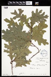 Quercus alba L. 619270[1004668]Westkaemper, Remberta s.n.1970-08-00 United States, Minnesota, Stearns, Stearns Co. Phillipi woods, Collegeville.;;125N;29W;, 45.59444 -94.36278 |
MIN:Plants | 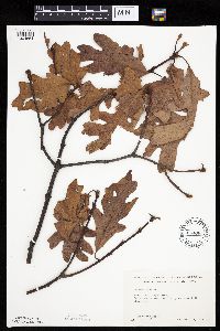 Quercus alba L. 644863[1004654]Neese, E. 10811973-12-19 United States, Minnesota, Ramsey, Ramsey Co.; between Lake Emily and Emmert St, Shoreview.;;030N;23W;, 45.041819 -93.130722 |
MIN:Plants | 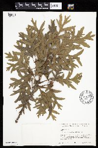 Quercus alba L. 669906[1004701]Grimm, Eric 961974-08-20 United States, Minnesota, Hennepin, Hennepin County...YMCA Camp Ihduhapi, Loretto...slope facing the NE side of Lake Independence.;;118N;24W;12, 45.04028 -93.64722 |
MIN:Plants | 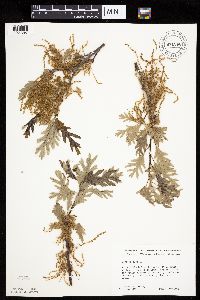 Quercus alba L. 671266[1004697]Ownbey, Gerald 51201976-05-16 United States, Minnesota, Washington, Washington Co.; Afton Hills Drive, 1.0 miles NW of Afton village.;;028N;20W;, 44.91302 -92.79779 |
MIN:Plants |  Quercus alba L. 679018[1004698]Ownbey, Gerald 49071975-04-12 United States, Minnesota, Washington, Afton Hills Drive .5 mi w of Afton village.;;028N;20W;, 44.90278 -92.79355 |
MIN:Plants |  Quercus alba L. 696698[1004665]Smith, Welby 7881978-08-05 United States, Minnesota, Wright, Wright Co.; 122N, R26W, SW1/4 Sec. 35, 1/4 mi. SE of North Lake.;;122N;26W;35, 45.33396 -93.929218 |
MIN:Plants |  Quercus alba L. 722589[1004722]Lustig, K. 10131979-08-23 United States, Minnesota, Anoka, Anoka County...Boot Lake SNA: 18 mi. SE of Cambridge, Sec. 17, 18, 19, 20, T33N, R22W.;Boot Lake Scientific Natural Area;033N;22W;00, 45.34797 -93.11302 |
MIN:Plants |  Quercus alba L. 730380[1004716]Phelps, V. 1361980-09-08 United States, Minnesota, Chisago, Wild River State Park. Goose Creek Natural Area: 5 mi. SE of Rush City. SW1/4 SE1/4. 036N 20W 7, 45.63434 -92.892 |
MIN:Plants |  Quercus alba L. 747157[1004669]Galatowitsch, S. 6101982-08-17 United States, Minnesota, Rice, Rice Co. Trout Lily Preserve: T110N, R20W, S1/2 NW1/4 SW1/4 of Sec. 20; part of NE1/4 SE1/4 Sec. 19.;Cannon River Trout Lily Scientific Natural Area;110N;20W;, 44.36306 -93.17125 |
MIN:Plants |  Quercus alba L. 747222[1004670]Galatowitsch, S. 7691982-09-10 United States, Minnesota, Rice, Rice Co. Trout Lily Preserve: T110N, R20W, S1/2 NW1/4 SW1/4 of Sec. 20; part of NE1/4 SE1/4 Sec. 19.;Cannon River Trout Lily Scientific Natural Area;110N;20W;, 44.36306 -93.17125 |
MIN:Plants |  Quercus alba L. 759426[1004649]Smith, Welby 64901982-06-25 United States, Minnesota, Wright, Hoglund Wildlife Management Area. Wright Co.; Hoglund State Wildlife Management Area, about 5 1/2 mi. SSE of Clearwater. SW1/4 SW1/4 Sec. 30, T122N, R26W Wright Co.; Hoglund State Wildlife Management Area, about 5 1/2 mi. SSE of Clearwater. SW1/4 SW1/4 Sec. 30, T122N, R26W.. 122N 26W 30, 45.3474 -94.00393 |
MIN:Plants |  Quercus alba L. 781911[1004696]Smith, Welby 93251984-06-23 United States, Minnesota, Mower, Lake Louise State Park. Mower Co.; Lake Louise State Park, about 1 mile north-northwest of LeRoy; on the banks of the Upper Iowa River; NW1/4 NE Mower Co.; Lake Louise State Park, about 1 mile north-northwest of LeRoy; on the banks of the Upper Iowa River; NW1/4 NE1/4 section 28, T 101N, R 14W.. 101N 14W 28, 43.68417 -92.97361 |
MIN:Plants |  Quercus alba L. 801195[1004725]Smith, Welby 119221986-06-28 United States, Minnesota, Anoka, Lamprey Pass Wildlife Management Area. Anoka County...Lamprey Pass State Wildlife Management Area, about 2 mi. SW of Forest Lake. NW1/4 SE1/4 Sec. 13, T32N, R22W. 032N 22W 13, 45.259567 -93.027476 |
MIN:Plants |  Quercus alba L. 829701[1004673]Nation, R. 11051993-06-25 United States, Minnesota, Winona, Whitewater Wildlife Management Area. Winona Co.; Whitewater Wildlife Management Area, 3-1/4 miles south and 1-3/4 miles west of Altura; T 107N R 10W SW1/4 of SW1/4 of Sec.36. 107N 10W 36, 44.09449 -92.0771 |
MIN:Plants |  Quercus alba L. 834864[1004724]Juhnke, C. 340CMJ1993-06-24 United States, Minnesota, Fillmore, Forestville State Park. Fillmore Co. T102N R12W Sec.19 SE SE SE. In yard NW of house at Mystery Cave 1 entrance;Forestville State Park;102N;12W;19, 43.62369 -92.31898 |
MIN:Plants |  Quercus alba L. 837459[1004718]Smith, Welby 176001990-08-01 United States, Minnesota, Morrison, Camp Ripley Military Reservation. Camp Ripley Military Reservation. Morrison Co. About 200 meters NE of the jct. of Normancy Road and Luzon Road; UTM: 384 Camp Ripley Military Reservation. Morrison Co. About 200 meters NE of the jct. of Normancy Road and Luzon Road; UTM: 384700E 5113500N T131N R30WSW1/4 of SW1/4 of Sec 8. 131N 30W 8, 46.15701 -94.42337 |
MIN:Plants | 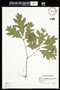 Quercus alba L. 839171[1004692]Smith, Welby 176761990-08-02 United States, Minnesota, Dodge, Dodge Co. About 1/2 mi E of Mantorville; T107N R16W NE1/4 of NE1/4 of Sec 21;Camp Ripley Military Reservation;107N;16W;21, 44.0630569 -92.7416687 |
MIN:Plants | 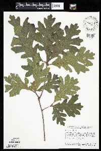 Quercus alba L. 841142[1004674]Smith, Welby 134751987-07-13 United States, Minnesota, Scott, Murphy-Hanrahan County Park Reserve. Scott County ... Murphy-Hanrahan Regional Park, on the south side of Hanrahan Lake, about 2 mi west of Burnsville ... SW1/4 NW1/4 sec.34, T115N R21W. 115N 21W 34, 44.7611122 -93.3363876 |
MIN:Plants | 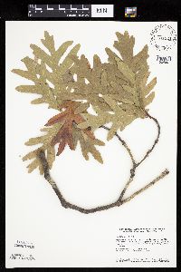 Quercus alba L. 841324[1004691]Smith, Welby 151001988-09-25 United States, Minnesota, Goodhue, Goodhue County...Hay Creek Recreation Area, about 2 mi S of Red Wing...NE1/4 NE1/4 sec.12, T112N R15W;Dorer Memorial Hardwood State Forest;112N;15W;12, 44.5247231 -92.5538864 |
MIN:Plants | 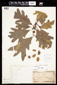 Quercus alba L. 98290[1004664]Anderson, A. An9431894-09-00 United States, Minnesota, Goodhue, Featherstone.;;;;, 44.475589 -92.63623 |
MIN:Plants |  Quercus alba L. 98291[1004715]Wheeler, William 6381899-08-26 United States, Minnesota, Houston, Jefferson;Dorer Memorial Hardwood State Forest;101N;04W;35, 43.50806 -91.28287 |
MIN:Plants |  Quercus x bebbiana C.K. Schneider 98293[1004712]Rosendahl, C.; Butters, F. 33991916-09-04 United States, Minnesota, Sherburne, 2 mi. S of Zimmerman.;;;;, 45.414338 -93.589962 |
MIN:Plants |  Quercus alba L. 98294[1004666]Ballard, C. B4851891-07-00 United States, Minnesota, Scott, Prior Lake.;;;;, 44.71333 -93.4225 |
MIN:Plants |  Quercus alba L. 98295[1004710]Butters, F. 39731920-07-20 United States, Minnesota, Wabasha, 2 mi. E of Lake City.;;;;, 44.44943 -92.2261 |
MIN:Plants |  Quercus alba L. 98296[1004660]Sheldon, Edmund s.n.1875-05-00 United States, Minnesota, Ramsey, Lake Vadnais. Ramsey Co.;;030N;22W;, 45.050494 -93.088138 |
MIN:Plants |  Quercus alba L. 98297[1004693]Butters, F.; et al. s.n.1916-09-00 United States, Minnesota, Hennepin, Eden Prairie Road.;;;;, 44.85472 -93.47056 |
MIN:Plants |  Quercus alba L. 98298[1004709]Rosendahl, C. s.n.1914-07-00 United States, Minnesota, Hennepin, Columbia Heights.;;;;, 45.04083 -93.26278 |
MIN:Plants |  Quercus alba L. 98299[1004661]Butters, F.; et al. s.n.1919-09-21 United States, Minnesota, Mille lacs, Ca. 3 mi. S of Wahkon.;;;;, 46.074855 -93.521073 |
MIN:Plants |  Quercus alba L. 98300[1004679]Butters, F.; et al. 33791916-08-18 United States, Minnesota, Isanti, Near north end of Long Lake, north of Cambridge. Isanti Conty;;036N;23W;13, 45.64028 -93.20528 |
MIN:Plants |  Quercus alba L. 98301[1004714]Butters, F.; et al. 34091916-09-00 United States, Minnesota, Hennepin, Eden Prairie Road.;;;;, 44.85472 -93.47056 |
MIN:Plants |  Quercus alba L. 98302[1004656]Butters, F. s.n.1924-07-24 United States, Minnesota, Stearns, Collegeville;;125N;29W;, 45.59444 -94.36278 |
MIN:Plants |  Quercus alba L. 98303[1004713]Butters, F.; et al. 33951916-09-05 United States, Minnesota, Kanabec, On E-W road, 10 mi. N of Mora. Kanabec Co.;;;;, 46.02173 -93.29361 |
MIN:Plants |  Quercus alba L. 98304[1004694]Butters, F.; et al. 33971916-09-05 United States, Minnesota, Kanabec, Along the road between Mora and Ogelvie. Kanabec County.;;039N;24W;00, 45.84267 -93.35495 |
MIN:Plants | 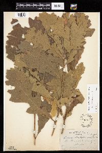 Quercus macrocarpa Michaux 98689[1005172]Butters, F.; Rosendahl, C. s.n.1919-09-20 United States, Minnesota, Aitkin, East of Mille Lacs;;;;, 46.310562 -93.475311 |
MIN:Plants | Quercus bicolor Willdenow 252018[1096388]Wheeler, William United States, Minnesota, Houston, Detailed locality information protected. This is typically done to protect rare or threatened species localities. |
MIN:Plants | Quercus bicolor Willdenow 334573[1004744]Anonymous United States, Minnesota, Ramsey, Detailed locality information protected. This is typically done to protect rare or threatened species localities. |
MIN:Plants | Quercus bicolor Willdenow 350032[1004745]Nielsen, E. United States, Minnesota, Goodhue, Detailed locality information protected. This is typically done to protect rare or threatened species localities. |
MIN:Plants | Quercus bicolor Willdenow 360146[1004756]Rosendahl, C.; Butters, F. United States, Minnesota, Houston, Detailed locality information protected. This is typically done to protect rare or threatened species localities. |
MIN:Plants | Quercus bicolor Willdenow 363225[1004747]Beach, W. United States, Minnesota, Ramsey, Detailed locality information protected. This is typically done to protect rare or threatened species localities. |
MIN:Plants | Quercus bicolor Willdenow 445553[1004734]Lee, Michael United States, Minnesota, Wabasha, Detailed locality information protected. This is typically done to protect rare or threatened species localities. |
MIN:Plants | Quercus bicolor Willdenow 476521[1004739]Lee, Michael; et al. United States, Minnesota, Wabasha, Detailed locality information protected. This is typically done to protect rare or threatened species localities. |
MIN:Plants | Quercus bicolor Willdenow 476523[1004732]Lee, Michael; et al. United States, Minnesota, Houston, Detailed locality information protected. This is typically done to protect rare or threatened species localities. |
MIN:Plants | Quercus bicolor Willdenow 482470[1004733]Lee, Michael; et al. United States, Minnesota, Houston, Detailed locality information protected. This is typically done to protect rare or threatened species localities. |
MIN:Plants | Quercus bicolor Willdenow 542571[1004753]Moore, John; et al. United States, Minnesota, Ramsey, Detailed locality information protected. This is typically done to protect rare or threatened species localities. |
MIN:Plants | Quercus bicolor Willdenow 603186[1004754]Dorn, Robert United States, Minnesota, Winona, Detailed locality information protected. This is typically done to protect rare or threatened species localities. |
MIN:Plants | 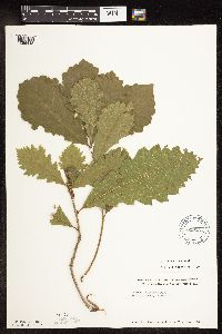 Quercus macrocarpa Michaux 619268[1096448]Westkaemper, Remberta s.n.1970-08-00 United States, Minnesota, Stearns, Stearns County...Phillipi Woods, Collegeville.;;125N;29W;00, 45.63025 -94.3255 |
MIN:Plants | 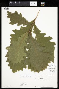 Quercus macrocarpa Michaux 622264[1005207]Westkaemper, Remberta s.n.1971-08-00 United States, Minnesota, Stearns, Stearns County...Philippi Woods, Lake Watab, Collegeville.;;125N;29W;00, 45.63025 -94.3255 |
MIN:Plants | Quercus bicolor Willdenow 484581[1004736]Lee, Michael United States, Minnesota, Wabasha, Detailed locality information protected. This is typically done to protect rare or threatened species localities. |
MIN:Plants | Quercus bicolor Willdenow 681417[1004751]Swanson, Steven United States, Minnesota, Houston, Detailed locality information protected. This is typically done to protect rare or threatened species localities. |
MIN:Plants | Quercus bicolor Willdenow 699480[1004752]Ziegler, S.; et al. United States, Minnesota, Houston, Detailed locality information protected. This is typically done to protect rare or threatened species localities. |
MIN:Plants | Quercus bicolor Willdenow 758683[1004738]Smith, Welby United States, Minnesota, Wabasha, Detailed locality information protected. This is typically done to protect rare or threatened species localities. |
MIN:Plants | Quercus bicolor Willdenow 98233[1004742]Rosendahl, C. United States, Minnesota, Hennepin, Detailed locality information protected. This is typically done to protect rare or threatened species localities. |
MIN:Plants | 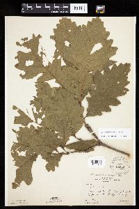 Quercus macrocarpa Michaux 98234[1005208]Butters, F.; et al. 29171915-06-20 United States, Minnesota, Dodge, N. fork of the Zumbro R. Dodge County;;;;, 44.03333 -92.86667 |
MIN:Plants | Quercus bicolor Willdenow 98339[1004759]Wheeler, William United States, Minnesota, Houston, Detailed locality information protected. This is typically done to protect rare or threatened species localities. |
MIN:Plants | Quercus bicolor Willdenow 98340[1096387]Wheeler, William United States, Minnesota, Houston, Detailed locality information protected. This is typically done to protect rare or threatened species localities. |
MIN:Plants | Quercus bicolor Willdenow 98341[1004757]Rosendahl, C. United States, Minnesota, Ramsey, Detailed locality information protected. This is typically done to protect rare or threatened species localities. |
MIN:Plants | Quercus bicolor Willdenow 98342[1004748]Rosendahl, C. United States, Minnesota, Hennepin, Detailed locality information protected. This is typically done to protect rare or threatened species localities. |
MIN:Plants | Quercus bicolor Willdenow 98343[1004743]Rosendahl, C. United States, Minnesota, Hennepin, Detailed locality information protected. This is typically done to protect rare or threatened species localities. |
MIN:Plants | Quercus bicolor Willdenow 98344[1004746]Rosendahl, C. United States, Minnesota, Ramsey, Detailed locality information protected. This is typically done to protect rare or threatened species localities. |
MIN:Plants | Quercus bicolor Willdenow 98345[1004758]Wheeler, William United States, Minnesota, Houston, Detailed locality information protected. This is typically done to protect rare or threatened species localities. |
MIN:Plants | Quercus bicolor Willdenow 98347[1004741]Rosendahl, C. United States, Minnesota, Hennepin, Detailed locality information protected. This is typically done to protect rare or threatened species localities. |
MIN:Plants |  Quercus macrocarpa Michaux 98348[1005209]Taylor, B. T4701891-06-00 United States, Minnesota, Waseca, Janesville;;108N;24W;33, 44.11643 -93.71771 |
MIN:Plants |  Quercus macrocarpa Michaux 98349[1005120]Butters, F.; Rosendahl, C. 40501921-06-18 United States, Minnesota, Chippewa, Bottomlands of the Minn. River, N.W. of Granite Falls.;;116N;39W;, 44.84743 -95.54384 |
MIN:Plants |  Quercus ellipsoidalis E.J. Hill 225979[1096404]Butters, F.; Rosendahl, C. 52221927-05-19 United States, Minnesota, Dakota, E of Lyndale Ave. Road, ca. 4 mi S of Minnesota River;;;;, 44.83901 -93.14889 |
Google Map
Google Maps is a web mapping service provided by Google that features a map that users can pan (by dragging the mouse) and zoom (by using the mouse wheel). Collection points are displayed as colored markers that when clicked on, displays the full information for that collection. When multiple species are queried (separated by semi-colons), different colored markers denote each individual species.