University of Minnesota
http://www.umn.edu/
612-625-5000
http://www.umn.edu/
612-625-5000
Minnesota Biodiversity Atlas
Bell Museum
Dataset: MIN-Plants
Taxa: Schoenoplectus
Search Criteria: excluding cultivated/captive occurrences
Bell Museum plants | |
 MIN:Plants |  Schoenoplectus acutus var. acutus (Muhlenberg ex Bigelow) ́. L̦ve & D. L̦ve 83726[1105296]Burglehaus, F. s.n.1891-07-00 United States, Minnesota, Hennepin, [no further data];;;;, 45 -93.47 |
MIN:Plants |  Schoenoplectus acutus var. acutus (Muhlenberg ex Bigelow) ́. L̦ve & D. L̦ve 83727[1105348]Menzel, Max s.n.1895-06-00 United States, Minnesota, Pipestone, Pipestone [assuming the quarry area; town generally noted as Pipestone City by collector];Pipestone National Monument;106N;46W;01, 44.01585 -96.31767 |
MIN:Plants |  Schoenoplectus acutus var. acutus (Muhlenberg ex Bigelow) ́. L̦ve & D. L̦ve 839315[1105281]Cholewa, A. 23781995-07-28 United States, Minnesota, Aitkin, Savanna Portage State Park. Aitkin Co. Savanna Portage State Park, about 17 mi NE of McGregor, NW end of Wolf Lake near boat access, T50N R22W S6 NE Aitkin Co. Savanna Portage State Park, about 17 mi NE of McGregor, NW end of Wolf Lake near boat access, T50N R22W S6 NE1/4 of NE1/4.. 050N 22W 6, 46.845996 -93.17745 |
MIN:Plants |  Schoenoplectus acutus var. acutus (Muhlenberg ex Bigelow) ́. L̦ve & D. L̦ve 83964[1105346]Ballard, C. B9481892-06-00 United States, Minnesota, Nicollet, Swan Lake, Nicollet Co.;;N;;, 44.30887 -94.262002 |
MIN:Plants |  Schoenoplectus acutus var. acutus (Muhlenberg ex Bigelow) ́. L̦ve & D. L̦ve 83966[1105308]Arthur, J.; et al. B2191886-07-23 United States, Minnesota, Saint Louis, Vermilion Lake;Superior National Forest;;;, 47.879148 -92.351718 |
MIN:Plants |  Schoenoplectus acutus var. acutus (Muhlenberg ex Bigelow) ́. L̦ve & D. L̦ve 83967[1105415]Sheldon, Edmund S8761891-07-00 United States, Minnesota, Brown, Sleepy Eye;;N;;, 44.325885 -94.684758 |
MIN:Plants |  Schoenoplectus acutus var. acutus (Muhlenberg ex Bigelow) ́. L̦ve & D. L̦ve 83974[1105350]Frost, W. F701892-06-00 United States, Minnesota, Meeker, Litchfield.;;N;;, 45.127185 -94.528047 |
MIN:Plants |  83722[1105435]Rosendahl, C.; et al. s.n.1917-09-28 United States, Minnesota, Anoka, Moore Lake;;030N;24W;, 45.07639 -93.2475 |
MIN:Plants |  83957[1105434]Rosendahl, C.; et al. s.n.1917-09-28 United States, Minnesota, Anoka, Moore Lake;;030N;24W;, 45.07639 -93.2475 |
MIN:Plants |  Schoenoplectus heterochaetus (Chase) Soj 263719[1105444]Nurnberger, P. P28511928-09-13 United States, Minnesota, Aitkin, Big Sandy Lake, Aitkin Co.;Savanna State Forest;N;;, 46.760517 -93.287213 |
MIN:Plants |  Schoenoplectus heterochaetus (Chase) Soj 291941[1105457]Hotchkiss, N.; et al. 41001930-09-03 United States, Minnesota, Aitkin, Backwater [Blackwater?] Lake, Aitkin Co.;;051N;27W;25, 46.877809 -93.709976 |
MIN:Plants |  Schoenoplectus heterochaetus (Chase) Soj 291944[1105456]Hotchkiss, N.; et al. 40911930-08-31 United States, Minnesota, Saint Louis, Big Rice Lake, St. Louis Co.;;060N;17W;, 47.673831 -92.497175 |
MIN:Plants |  Schoenoplectus heterochaetus (Chase) Soj 291980[1021731]Hotchkiss, N.; Jones, Percy 39491930-07-16 United States, Minnesota, Brown, Lake Hanska;;;;, 44.145015 -94.61931 |
MIN:Plants |  Schoenoplectus heterochaetus (Chase) Soj 291983[1105455]Hotchkiss, N.; et al. 39711930-07-21 United States, Minnesota, [no further data];;;;, 46 -94 |
MIN:Plants |  Schoenoplectus heterochaetus (Chase) Soj 292018[1105453]Hotchkiss, N.; et al. 40051930-00-00 United States, Minnesota, Pope, NE quarter of Sec.16, Langhei Twp, Pope Co.;;123N;39W;16, 45.462896 -95.572119 |
MIN:Plants |  346225[1105463]Moyle, J. B. 29021937-08-17 United States, Minnesota, Freeborn, northern part of county, 43.673844 -93.348816 |
MIN:Plants |  Schoenoplectus heterochaetus (Chase) Soj 347584[1105452]Moyle, J. 31871939-07-28 United States, Minnesota, Kandiyohi, Kandiyohi Co.; 2 mi W and 6 mi N of Willmar;;120N;35W;, 45.196193 -95.062789 |
MIN:Plants |  Schoenoplectus heterochaetus (Chase) Soj 385845[1105454]Moyle, J. 39951945-08-02 United States, Minnesota, Freeborn, Freeborn Co. S of Albert Lea;;N;;, 43.648013 -93.368266 |
MIN:Plants |  Schoenoplectus heterochaetus (Chase) Soj 385846[1105442]Moyle, J. 41221945-08-08 United States, Minnesota, Steele, Steele Co. Rice L.;Rice Lake State Park;107N;19W;, 44.066335 -93.10586 |
MIN:Plants |  Schoenoplectus heterochaetus (Chase) Soj 442945[1105450]Lakela, Olga 125921951-06-23 United States, Minnesota, Saint Louis, White Iron Lake, Burley's Resort, near Ely, St. Louis Co.;;N;;, 47.873003 -91.801937 |
MIN:Plants |  Schoenoplectus heterochaetus (Chase) Soj 443764[1105441]Smith, Welby 189841991-06-25 United States, Minnesota, Todd, Buckhorn Wildlife Management Area. Todd Co.; Buckhorn State Wildlife Management Area, about 2 miles east of Grey Eagle. Margin of Buckhorn Lake; Todd Co.; Buckhorn State Wildlife Management Area, about 2 miles east of Grey Eagle. Margin of Buckhorn Lake; T 127N R 32W NW1/4 of SW1/4 of Sec 10. 127N 32W 10, 45.8250008 -94.6986084 |
MIN:Plants |  Schoenoplectus heterochaetus (Chase) Soj 462737[1105443]Lakela, Olga 147111952-07-10 United States, Minnesota, Saint Louis, St. Louis Co.; Cranberry Bay off Rainy Lake;Voyageurs National Park;071N;21W;, 48.606257 -93.024038 |
MIN:Plants |  Schoenoplectus heterochaetus (Chase) Soj 463343[1105451]Lakela, Olga 151961952-07-16 United States, Minnesota, Saint Louis, St. Louis Co.; Daly Bay, S shore of Kabetogama Lake;Voyageurs National Park;N;;, 48.455602 -92.896321 |
MIN:Plants |  Schoenoplectus heterochaetus (Chase) Soj 463439[1105445]Lakela, Olga 136391952-08-23 United States, Minnesota, Saint Louis, St. Louis Co.; Crooked Lake; Curtain Falls;Boundary Waters Canoe Area Wilderness / Superior National Forest;066N;12W;, 48.186787 -91.869968 |
MIN:Plants |  Schoenoplectus heterochaetus (Chase) Soj 492967[1105446]Lakela, Olga 165631953-08-05 United States, Minnesota, Saint Louis, St. Louis Co.; Lac La Croix, at Skala's Resort;Boundary Waters Canoe Area Wilderness / Superior National Forest;N;;, 48.343611 -92.122778 |
MIN:Plants |  Schoenoplectus heterochaetus (Chase) Soj 525692[1105448]Lakela, Olga 193471955-08-17 United States, Minnesota, Saint Louis, St. Louis Co.; in Cranberry Bay of Rainy Lake;Voyageurs National Park;071N;21W;, 48.606257 -93.024038 |
MIN:Plants |  Schoenoplectus heterochaetus (Chase) Soj 744743[1105440]Converse, C. 14311982-07-04 United States, Minnesota, Douglas, Staffanson Prairie.;Staffanson Prairie, The Nature Conservancy;127N;40W;18, 45.810665 -95.748005 |
MIN:Plants |  Schoenoplectus heterochaetus (Chase) Soj 746168[1105447]Smith, Welby 45321981-06-25 United States, Minnesota, Wright, Wright County ... The southwest arm of Pelican Lake, about 5 mi north-east of Buffalo ... NW1/4 SE1/4 sec.12, T120N R25W;;120N;25W;12, 45.216197 -93.775961 |
MIN:Plants |  Schoenoplectus heterochaetus (Chase) Soj 83724[1021732]MacMillan, C.; Sheldon, Edmund 5961894-06-26 United States, Minnesota, Lake of the Woods, Garden Island, Lake of the Woods;Northwest Angle;166N;33W;, 49.193258 -94.893832 |
MIN:Plants |  291998[1105460]Hotchkiss, Neil 40861930-08-31 United States, Minnesota, Saint Louis, Big Rice Lake [Superior National Forest; T60N R17W], 47.673831 -92.497175 |
MIN:Plants |  346239[1105461]Moyle, J. B. 32121938-09-22 United States, Minnesota, Chippewa, In Drywood Lake (Griffins), 45.123685 -95.455936 |
MIN:Plants |  346740[1105464]Moyle, J. B. 31931938-06-28 United States, Minnesota, Kandiyohi, Near Willmar [T119N R35W], 45.110139 -95.062995 |
MIN:Plants |  347560[1021738]Moyle, J. B. 31931938-08-19 United States, Minnesota, Lac Qui Parle, near Lac qui Parle [T118N R42W], 45.02185 -95.919725 |
MIN:Plants |  413189[1021737]Moore, John W. 111401939-07-25 United States, Minnesota, Lake of the Woods, Growing along the bank of the Inlet, W side of Pine Creek, Angle Inlet [Northwest Angle; T168N R35W], 49.339876 -95.067038 |
MIN:Plants |  442501[1021736]Lakela, Olga 133241951-07-17 United States, Minnesota, Saint Louis, Ash River bend at the Frontier Lodge [Kabetogama State Forest; T68N R19W S4], 48.404426 -92.79166 |
MIN:Plants |  670561[1021735]Heitlinger, Mark E. 2741971-07-11 United States, Minnesota, McLeod, Schaefer Prairie. SE corner of tract. SE1/4 of sec 34, T115N R29W, 44.72505 -94.30491 |
MIN:Plants |  83958[1105462]MacMillan, C. 4871894-06-23 United States, Minnesota, Roseau, Warroad River, 48.930291 -95.287489 |
MIN:Plants |  Schoenoplectus pungens (Vahl) Palla 222020[1105551]Rosendahl, C.; Butters, F. 50881926-08-03 United States, Minnesota, Anoka, Moore Lake...Anoka County;;030N;24W;23, 45.071682 -93.257896 |
MIN:Plants |  Schoenoplectus pungens (Vahl) Palla 270414[1105502]McLaughlin, David 4111986-08-25 United States, Minnesota, Crow Wing, SE side of Pelican Lake, near lake shore drive.;;136N;28W;, 46.588001 -94.204156 |
MIN:Plants |  Schoenoplectus pungens (Vahl) Palla 277633[1105513]Hotchkiss, N.; et al. 3271930-07-23 United States, Minnesota, Lyon, Dennin's Slough, Rock Lake Twp, Secs. 3,4. Lyon Co.;;109N;42W;00, 44.239648 -95.896874 |
MIN:Plants | 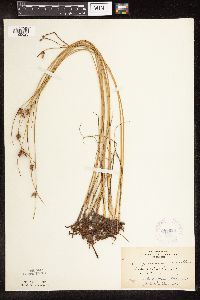 Schoenoplectus pungens (Vahl) Palla 281920[1105523]Fellows, Sara 551932-07-12 United States, Minnesota, Pipestone, Pipestone. At Ponset.;;106N;46W;, 43.979723 -96.367859 |
MIN:Plants | 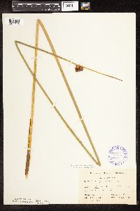 Schoenoplectus pungens (Vahl) Palla 336633[1105528]Smith, L.; Moyle, J. 4481936-08-31 United States, Minnesota, Winnibigoshish Lake;Chippewa National Forest / Leech Lake Indian Reservation;;;, 47.447209 -94.213181 |
MIN:Plants | 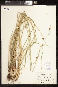 Schoenoplectus pungens (Vahl) Palla 338073[1105498]Moyle, J. 22941936-08-09 United States, Minnesota, Lac Qui Parle, Lac qui Parle;;N;;, 45.051472 -95.928802 |
MIN:Plants | 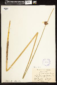 Schoenoplectus pungens (Vahl) Palla 338088[1105499]Smith, L.; Moyle, J. 4501936-08-31 United States, Minnesota, Winnibigoshish Lake;Chippewa National Forest / Leech Lake Indian Reservation;;;, 47.447209 -94.213181 |
MIN:Plants |  Schoenoplectus pungens (Vahl) Palla 338321[1105500]Moyle, J. 23711936-08-15 United States, Minnesota, Otter Tail, near Rush Lake;;N;;, 46.257964 -96.151559 |
MIN:Plants |  Schoenoplectus pungens (Vahl) Palla 347645[1105497]Moyle, J. 31781938-08-11 United States, Minnesota, Mille Lacs, Lake Mille Lacs, Isle;;N;;, 46.110955 -93.494831 |
MIN:Plants |  Schoenoplectus pungens (Vahl) Palla 353304[1105512]Moyle, J.; et al. 17101934-08-14 United States, Minnesota, Otter Tail, McDonald Lake. Otter Tail Co.;;;;, 46.569306 -95.758553 |
MIN:Plants |  Schoenoplectus pungens (Vahl) Palla 353396[1105492]Moyle, J.; et al. 1892A1934-08-20 United States, Minnesota, Saint Louis, Bass Lake, near Ely;Superior National Forest;063N;12W;, 47.933092 -91.861065 |
MIN:Plants |  Schoenoplectus pungens (Vahl) Palla 353731[1105501]Moyle, J.; et al. 19101934-08-20 United States, Minnesota, Saint Louis, N side of Bass Lake, Ely;Superior National Forest;063N;12W;, 47.933092 -91.861065 |
MIN:Plants |  Schoenoplectus pungens (Vahl) Palla 359747[1105515]Rosendahl, C.; et al. 69751938-09-05 United States, Minnesota, Beltrami, Red Lake, near the mouth of the Tamarack River.;Red Lake State Forest;154N;30W;, 48.149321 -94.488234 |
MIN:Plants |  Schoenoplectus pungens (Vahl) Palla 360425[1021743]Rosendahl, C.; Butters, F. 68561937-08-26 United States, Minnesota, Itasca, W of Scenic State Park;Scenic State Park;N;;, 47.715773 -93.56297 |
MIN:Plants |  Schoenoplectus pungens (Vahl) Palla 360566[1105505]Lakela, Olga 42431940-09-14 United States, Minnesota, Saint Louis, St. Louis River bottom lands at the Arrowhead Bridge, Duluth;;N;;, 46.719663 -92.147691 |
MIN:Plants |  Schoenoplectus pungens (Vahl) Palla 361449[1105524]Butters, F.; et al. 65521934-09-06 United States, Minnesota, Aitkin, Farm Island Lake.;;;;, 46.374307 -93.748617 |
MIN:Plants |  Schoenoplectus pungens (Vahl) Palla 369093[1105504]Lakela, Olga 46721941-08-06 United States, Minnesota, Saint Louis, Minnesota Point, Duluth;Minnesota Point;049N;13W;19, 46.75082 -92.072247 |
MIN:Plants |  Schoenoplectus pungens (Vahl) Palla 380216[1105503]Lakela, Olga 54911943-09-11 United States, Minnesota, Saint Louis, island in Superior Bay, Duluth;;N;;, 46.744397 -92.073854 |
MIN:Plants |  Schoenoplectus pungens (Vahl) Palla 385849[1105510]Moyle, J. 3963a1945-08-27 United States, Minnesota, Lyon, Lake Marshall;;N;;, 44.388338 -95.736642 |
MIN:Plants |  Schoenoplectus pungens (Vahl) Palla 404975[1105511]Benson, Robert 2151941-09-02 United States, Minnesota, Otter Tail, near Fergus Falls;;N;;, 46.283015 -96.077558 |
MIN:Plants |  Schoenoplectus pungens (Vahl) Palla 429509[1105487]Smith, Welby 153561989-06-11 United States, Minnesota, Le Sueur, Ottawa Bluffs, The Nature Conservancy. LeSueur County...In the Minnesota Valley, about 1.5 miles south of Ottawa; southwest-facing bluff; NW1/4 SE1/4 section 3, T 110N R 26W. 110N 26W 3, 44.3625 -93.9363889 |
MIN:Plants |  Schoenoplectus pungens (Vahl) Palla 433146[1105472]Myhre, K. 59681995-07-26 United States, Minnesota, Mahnomen, White Earth Indian Reservation. Mahnomen Co.; Located 2 miles northeast of the town of Waubun. Plants occur along the north shore of Waubun Lake; T 143N Mahnomen Co.; Located 2 miles northeast of the town of Waubun. Plants occur along the north shore of Waubun Lake; T 143N R 41W NW1/4 of NW1/4 of sec 16. 143N 41W 16, 47.20116 -95.879151 |
MIN:Plants |  Schoenoplectus pungens (Vahl) Palla 433424[1105475]Myhre, K. 56161995-06-19 United States, Minnesota, Crow Wing, Crow Wing Co.; Locted 4 miles southeast of the town of Brainerd. Plants occur along the south bays of Perch Lake; T 133N Crow Wing Co.; Locted 4 miles southeast of the town of Brainerd. Plants occur along the south bays of Perch Lake; T 133N R 29W SW1/4 of NE1/4 of Sec 13. 133N 29W 13, 46.332469 -94.275724 |
MIN:Plants | 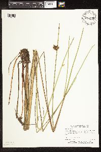 Schoenoplectus torreyi (Olney) Palla 433425[1105476]Myhre, Karen M. 60481995-08-09 United States, Minnesota, Aitkin, Aitkin Co.; Located 3 miles southeast of the town of Aitkin. Plants occur along the southeast bays of Nord Lake; T 46N R Aitkin Co.; Located 3 miles southeast of the town of Aitkin. Plants occur along the southeast bays of Nord Lake; T 46N R 26W NE1/4 of NE1/4 of Sec 8. 046N 26W 8, 46.482345 -93.653878 |
MIN:Plants | 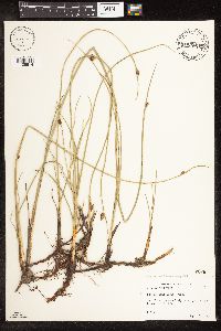 Schoenoplectus pungens (Vahl) Palla 433435[1105514]Abbott, Robinson s.n.1989-09-05 United States, Minnesota, Grant, Grant County...Big Lake, just E. of Herman on rt. 27.;;127N;43W;18, 45.810499 -96.120024 |
MIN:Plants | 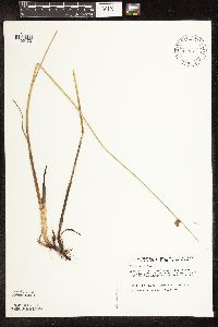 Schoenoplectus pungens (Vahl) Palla 439977[1105470]Harris, Fred 930141993-06-22 United States, Minnesota, Polk, Polk Co. Chicog WMA; NW1/4 NE1/4 sec 33 T148N R45W, CBS site 26;Chicog Wildlife Management Area;148N;45W;33, 47.593704 -96.397789 |
MIN:Plants | 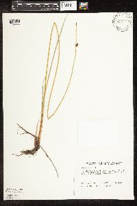 Schoenoplectus pungens (Vahl) Palla 441319[1105465]Harris, Fred 930721993-07-20 United States, Minnesota, Polk, Polk Co. Svedarsky's Fen; SW1/4 NE1/4 Sec 17 T149N R45W, CBS site 20;Pankratz Memorial Prairie, The Nature Conservancy;149N;45W;17, 47.723974 -96.448899 |
MIN:Plants |  Schoenoplectus pungens (Vahl) Palla 443171[1021745]Lakela, Olga 134881951-07-20 United States, Minnesota, Saint Louis, Big Sturgeon Lake N of Hibbing;;N;;, 47.68065 -93.04596 |
MIN:Plants |  Schoenoplectus pungens (Vahl) Palla 453620[1105480]Myhre, K. 51721994-07-06 United States, Minnesota, Itasca, Itasca Co.; located along the southwest shore of Ball Club Lake; T 144N R 26W NE1/4 of NW1/4 of sec 1;Chippewa National Forest / Leech Lake Indian Reservation;144N;26W;1, 47.31779 -93.911914 |
MIN:Plants |  Schoenoplectus pungens (Vahl) Palla 460559[1021746]Smith, Welby 132191987-06-27 United States, Minnesota, Pipestone, Altona Wildlife Management Area. Pipestone Co.; Altona State Wildlife Management Area, about 1.5 miles southeast of Verdi. NW1/4 NW1/4 section 1, T 108N Pipestone Co.; Altona State Wildlife Management Area, about 1.5 miles southeast of Verdi. NW1/4 NW1/4 section 1, T 108N R 46W. 108N 46W 1, 44.1966667 -96.3249969 |
MIN:Plants |  Schoenoplectus pungens (Vahl) Palla 475315[1105530]Smith, Welby 146001988-07-25 United States, Minnesota, Pine, Nemadji State Forest. Pine Co.; Along the west shore of Pickeral Lake, about 5 miles south-southwest of Holyoke; SE1/4 SW1/4 section 1, T 45N Pine Co.; Along the west shore of Pickeral Lake, about 5 miles south-southwest of Holyoke; SE1/4 SW1/4 section 1, T 45N R 17W. 045N 17W 1, 46.4047241 -92.4394455 |
MIN:Plants |  Schoenoplectus pungens (Vahl) Palla 497628[1105474]Harris, Fred 950621995-08-14 United States, Minnesota, Carver, Carver Co. ... Seminary Fen; in releve plot; at foot of N side of Minnesota river valley ... T116 R23 SE1/4 of of NW1/4 of Sec 35. 116N 23W 35, 44.811969 -93.55132 |
MIN:Plants |  Schoenoplectus pungens (Vahl) Palla 507185[1105509]Moore, John 207851950-09-12 United States, Minnesota, Stevens, Along the E shore of Page Lake, N of Hancock.;;124N;41W;, 45.542242 -95.809369 |
MIN:Plants |  Schoenoplectus pungens (Vahl) Palla 516098[1105467]Smith, Welby 186751991-06-05 United States, Minnesota, Redwood, Redwood Co.; in the Minnesota Valley, about 5.5 mi NW of Delhi; T114N R37W SW1/4 of SW1/4 of sec 22;;114N;37W;22, 44.6583328 -95.2975006 |
MIN:Plants |  Schoenoplectus pungens (Vahl) Palla 520005[1105468]Smith, Welby 164141989-09-06 United States, Minnesota, Benton, Benton County...on the E bank of the Mississippi River in Rice...NE1/4 NE1/4 sec.36, T38N R32W;;038N;32W;36, 45.7483333 -94.26 |
MIN:Plants |  Schoenoplectus pungens (Vahl) Palla 541393[1105506]Scharf, J. 191956-08-29 United States, Minnesota, Murray, Chandler Marsh, Moen Tract. 2 mi. N-NE of Chandler.;Chandler Marsh Wildlife Management Area;106N;42W;, 43.978855 -95.883595 |
MIN:Plants |  Schoenoplectus pungens (Vahl) Palla 541506[1105481]Scharf, J. s.n.1956-07-27 United States, Minnesota, Redwood, Redwood County ... state owned marsh;;;;, 44.399019 -95.232147 |
MIN:Plants |  Schoenoplectus pungens (Vahl) Palla 541389[1105507]Scharf, J. 151956-08-24 United States, Minnesota, Murray, Murray County ... Chandler Marsh. "Area to be flooded" transect. 1 mile n.e. of Chandler.;Chandler Marsh Wildlife Management Area;106N;42W;, 43.978855 -95.883595 |
MIN:Plants |  Schoenoplectus pungens (Vahl) Palla 549845[1105550]Moore, John; et al. 222651954-09-22 United States, Minnesota, Lincoln, Lincoln County...island at the NE end of Lake Benton;;110N;45W;25, 44.306759 -96.210724 |
MIN:Plants |  Schoenoplectus pungens (Vahl) Palla 568924[1105549]Moore, John; et al. 251681960-07-15 United States, Minnesota, Anoka, Anoka County...W shore of Fish Lake;Cedar Creek National History Area;034N;23W;, 45.428063 -93.203997 |
MIN:Plants |  Schoenoplectus pungens (Vahl) Palla 574729[1105554]Moore, John 245781959-06-04 United States, Minnesota, Blue Earth, N shore of Loon Lake;;N;;, 44.099011 -94.177453 |
MIN:Plants |  Schoenoplectus pungens (Vahl) Palla 576800[1105536]Isaak, Daniel s.n.1960-06-21 United States, Minnesota, Isanti, Horseshoe Lake.;;034N;22W;, 45.427323 -93.081077 |
MIN:Plants |  Schoenoplectus pungens (Vahl) Palla 695863[1105537]Clemants, Steven 9851977-10-09 United States, Minnesota, Crow Wing, Pelican Lake, Sunset Beach. 13 mi. N of Brainerd.;;136N;28W;, 46.588001 -94.204156 |
MIN:Plants |  Schoenoplectus pungens (Vahl) Palla 707936[1105485]Smith, Welby 12551979-08-03 United States, Minnesota, Lac Qui Parle, Along the S shore of "Salt Lake". 3.5 mi. S-SW of Marietta.;;117N;46W;5, 44.972372 -96.443681 |
MIN:Plants |  Schoenoplectus pungens (Vahl) Palla 709708[1105539]Wheeler, Gerald 47171979-08-03 United States, Minnesota, Lac Qui Parle, Salt Lake. Approximately 3.5 mi SW of Marietta.;;117N;46W;5, 44.972372 -96.443681 |
MIN:Plants |  Schoenoplectus pungens (Vahl) Palla 711470[1105508]Smith, Welby 11021979-07-06 United States, Minnesota, Anoka, Anoka Co. Within the municiple boundaries of Fridley. "West Moore Lake Dunes Natural History Area.";;030N;24W;, 45.080985 -93.255535 |
MIN:Plants |  Schoenoplectus pungens (Vahl) Palla 722300[1105486]Wheeler, Gerald 53491980-08-10 United States, Minnesota, Anoka, Anoka County...Ham Lake; Sec. 21 T32N R23W;;032N;23W;21, 45.247884 -93.214062 |
MIN:Plants |  Schoenoplectus pungens (Vahl) Palla 722563[1105484]Lustig, K. 6471979-07-05 United States, Minnesota, Anoka, Anoka County...Boot Lake SNA: 18 mi SE of Cambridge; Sec. 17, 18, 19, 20, T33N, R22W;Boot Lake Scientific Natural Area;033N;22W;00, 45.340658 -93.081463 |
MIN:Plants |  Schoenoplectus pungens (Vahl) Palla 744595[1105540]Converse, C. 20061982-08-09 United States, Minnesota, Pope, Ordway Prairie;Ordway Prairie, The Nature Conservancy;123N;36W;30, 45.434262 -95.245018 |
MIN:Plants |  Schoenoplectus pungens (Vahl) Palla 746050[1105543]Smith, Welby 48431981-07-14 United States, Minnesota, Yellow Medicine, Sioux Nation State Wildlife Managemnet Area. About 8 mi W-SW of Canby.;Sioux Nationalion Wildlife Management Area;114N;46W;17, 44.681835 -96.429592 |
MIN:Plants |  Schoenoplectus pungens (Vahl) Palla 746098[1105542]Smith, Welby 46431981-07-02 United States, Minnesota, Clay, About 3 mi E-SE of the jcn of State Hwy 9 and County Hwy 34 in Felton.;;142N;46W;36, 47.071261 -96.447104 |
MIN:Plants |  Schoenoplectus pungens (Vahl) Palla 746314[1105538]Smith, Welby 53111981-08-06 United States, Minnesota, Jackson, About 6? mi NE of Lakefield. NE facing bluff in the Des Moines River Valley.;;103N;35W;7, 43.739341 -95.084917 |
MIN:Plants |  Schoenoplectus pungens (Vahl) Palla 746111[1105490]Smith, Welby 42191981-06-11 United States, Minnesota, Polk, About 3 mi NE of Harold..;Pankratz Memorial Prairie, The Nature Conservancy;149N;45W;17, 47.723974 -96.448899 |
MIN:Plants |  Schoenoplectus pungens (Vahl) Palla 759029[1105541]Smith, Welby 75491982-09-01 United States, Minnesota, Mahnomen, Mahnomen Co. Waubun State Wildlife Management Area. About 1 mi S of Waubun (town). NW1/4 of SW1/4 of sec.25, T143N R42W;Waubun Prairie Wildlife Management Area / White Earth Indian Reservation;143N;42W;25, 47.173142 -95.943662 |
MIN:Plants |  Schoenoplectus pungens (Vahl) Palla 782208[1105482]Dana, R. 850231985-06-30 United States, Minnesota, Clay, Clay Co.; NE1/4 SEc.13, T141N R46W. B Bar B Ranch. Below a beach ridge of Glacial Lake Agassiz.;;141N;46W;13, 47.027886 -96.447094 |
MIN:Plants |  Schoenoplectus pungens (Vahl) Palla 782209[1105488]Dana, R. 850091985-06-28 United States, Minnesota, Clay, Former beach ridge of Glacial Lake Agassiz.. E part SE1/4 of section;<No data>;140N;46W;22, 46.927146 -96.473757 |
MIN:Plants |  Schoenoplectus pungens (Vahl) Palla 789602[1105483]Smith, Welby 112111985-08-15 United States, Minnesota, Cottonwood, Expandere State Wildlife Management Area, about 13 mi W-NW of Windom;Expandere Wildlife Management Area;105N;38W;1, 43.927573 -95.35047 |
MIN:Plants |  Schoenoplectus pungens (Vahl) Palla 814621[1105493]Wheeler, Gerald 113271988-07-24 United States, Minnesota, Big Stone, Ca. 6 mi. N-NE of Ortonville; N of Rte. 62. Along the margin of Thielke Lake.;;122N;46W;11, 45.391492 -96.400528 |
MIN:Plants |  Schoenoplectus pungens (Vahl) Palla 815703[1105478]Wheeler, Gerald 120681988-09-05 United States, Minnesota, Clay, Ca. 5.8 mi. E of Hawley; E of Rte. 118. Along Sand Lake (W shore). E1/2 SE1/4 Sec. 12 T139N R44W (Eglon Twp.).;;139N;44W;12, 46.87008 -96.185789 |
MIN:Plants |  Schoenoplectus pungens (Vahl) Palla 816044[1105471]Wheeler, Gerald 109931988-06-27 United States, Minnesota, Traverse, Ca. 8.5 mi. SW of Wheaton; E of Rte. 27. NW1/4 NE1/4 Sec. 13, T126N, R48W, Windsor Twp.;;126N;48W;13, 45.723544 -96.64617 |
MIN:Plants | 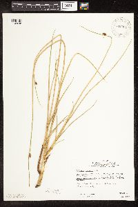 Schoenoplectus pungens (Vahl) Palla 816054[1105545]Wheeler, Gerald 118101988-08-17 United States, Minnesota, Norman, Ca. 6.4 mi. E-NE of Twin Valley; S of Wild Rice River. E1/2 NE1/4 NW1/4 Sec. 22, T144N, R43W, Fossum Twp.;;144N;43W;22, 47.274896 -96.12012 |
MIN:Plants | 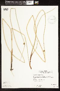 Schoenoplectus pungens (Vahl) Palla 816182[1105544]Wheeler, Gerald 120451988-09-03 United States, Minnesota, Wilkin, Ca. 8.5 mi SW of Campbell, N of rte 55, bordering Bois de Sioux River; S1/2 Sec. 29 T130N R47W (Campbell Township);;130N;47W;29, 46.0534 -96.56373 |
MIN:Plants | 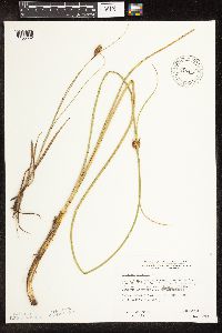 Schoenoplectus pungens (Vahl) Palla 816440[1105552]Wheeler, Gerald 122041988-09-11 United States, Minnesota, Big Stone, Tangen Wildlife Management Area. Big Stone Co.; Ca. 2.5 mi. E-NE of Ortonville; waterfowl area S of Rte. 64. NW1/4 SW1/4 NE1/4 Sec. 12, T121N, R46W, Ortonville Twp.. 121N 46W 12, 45.305068 -96.379422 |
Google Map
Google Maps is a web mapping service provided by Google that features a map that users can pan (by dragging the mouse) and zoom (by using the mouse wheel). Collection points are displayed as colored markers that when clicked on, displays the full information for that collection. When multiple species are queried (separated by semi-colons), different colored markers denote each individual species.